Sunday, February 23, 2020

Crazy Cold Front Starts Off A Stormy Day

Sunday mornings are supposed to be calm and sunny, right? Apparently not here...where a strong cold front with embedded thunderstorms jolted us all awake! Let’s take a look at what happened on this very not calm Sunday morning...

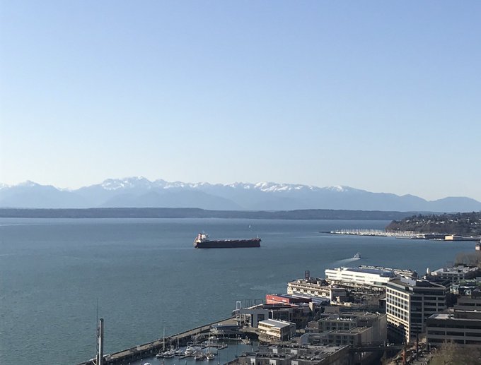
As we slept, a cold front gathered strength to the west, as rain and wind moved in off the coast. By the time this front reached the South & Central Sound, it had become quite a strong cold front. Take a look at the radar image below...I’m sure you can pick out the front.


That was at 7 AM on Sunday morning, around the time the front was moving through areas of Tacoma, Fife, Federal Way, and Kent. This is when heavy, wind-driven rain woke me up. As the front continued to move eastward, through Puyallup, Bonney Lake, and the surrounding areas, it slightly weakened, but it still brought heavy rain, strong winds, hail (some accumulating), and power outages. 

After the front moved through, lighter rain and some gusty winds followed. Let’s take a look at the effects of the front.

Temperature dropped 8-10 degrees between 7:00 AM and 7:30 AM
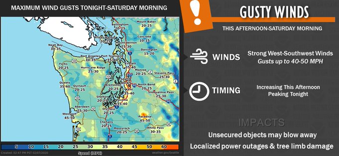
Winds gusted 30-50 mph
Around 0.2 inches of rain fell in less than 30 minutes
Accumulating hail was reported in many places
Multiple lightning strikes were recorded during the worst of the front
Over 20,000 people lost power in the Puget Sound Area

In this picture from Gunner H. in Bonney Lake, you can see the hail-filled runoff draining down the street. (Outlined in red)


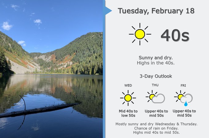
In wake of this front, it will be a cooler day, with highs only topping in the mid-40s. Rain will continue through the day, and there is a chance of thunderstorms from 10 am onward. Additionally, winds will move through the area today, especially around & after 4 pm. Gusts will be 40-50 mph in the South Sound.

If you are driving to the mountains today, be prepared for winter storm conditions, with 12-18 inches of snow likely on all the passes today.

Friday, February 21, 2020

Last Sunny Day Before Rain Returns

We have been blessed with a beautiful week of sunny weather!! Yesterday (20th), Puyallup recorded a high of 64 degrees!! That was the second straight day with a high above 60 degrees! It's possible one more time today...the final sunny day before some rain moves in this weekend. Let's take a look at what's in store!

Friday will be another beautiful, sunny day. Highs will be 55-60, with lows tonight only in the upper 30s-low 40s...much warmer than last night. 

Clouds begin to increase on Saturday, and a there is a chance of showers through the day. 

A bigger weather system comes in on Sunday, with heavier and more widespread rain, gusty winds, and heavy mountain snow. This graphic from NWS Seattle shows what to expect. 


With all the weather systems that we have had earlier this month, this will be just another ordinary storm. Expect more widespread rain, totaling around a half inch. Winds will gust 20-40 mph. There will also be snow in the mountains, so be safe if you are traveling across the mountains.

Wednesday, February 19, 2020

Temperature Increases 35 Degrees In 11 Hours

As of 3:20 pm on February 19th, the Puyallup has reached 61 degrees! Less than 12 hours ago...it was 26 degrees! That's a 35 degree increase in under 12 hours!!

So how could it go from a cold, frosty morning to a nearly spring-like day?

Since it was a cold and clear night, having no clouds in the sky allowed for all the day's remaining heat to radiate back to space. Because of this, the temperature dropped down to 26 degrees. Additionally, since we're located in the valley, the temperature was a couple degrees colder here, since heat rises. 

As it warmed today, there was again no clouds, so the temperature could warm as much as possible! That peak happened to be 61 degrees!! 

This picture was taken by Seattle Weather Blog on Twitter...with the caption, "Beat that, America!"

Image

Today was a beautiful, sunny day! Expect more of the same tomorrow, with lows tonight in the mid-upper 20s again. 

Monday, February 17, 2020

Sunny Days & Cold Nights This Week

Monday night will be cold, with lows 27-30. Icy roads are possible each morning this week, so drive prepared. Tuesday, Wednesday, and Thursday will be sunny, with highs 45-52, and lows 27-34! 

This graphic from NWS Seattle shows the expected weather for the week. 

Image

After Friday...rain will return, with a slight chance of rain/snow!! 
*SLIGHT* 😉

Saturday, February 15, 2020

Breezy Weather With Rain, Then Clearing & Colder

After nearly a month of very active weather, this has been a calm week. We will be impacted by a couple weak weather systems through this weekend, and then we will have colder weather and clearing under a high pressure ridge. Let's take a look at what to expect...

This UW WRF model shows light rain, totaling around 0.1-0.2 inches. This rain won't have any impact on rivers. 

Breezy conditions are likely through Sunday night, with winds 10-25 mph, and gusts 25-40 mph possible. 

After the rain and wind moves through, a high pressure ridge will build, and it will clear out. We most likely have sunny weather from midday Monday through late Wednesday. Highs will be 45-55, and lows will be 27-35. It will be cold and possibly icy in the mornings!

Monday, February 10, 2020

What Happened During Friday Night's Storm?

It is finally sunny!!! While there is a break in the active weather for a few days, we will examine what happened on Friday night...when heavy rain and strong winds moved through the area in just 20 minutes.

A strong, narrow cold front moved through the area on Friday night. This front had a fast-moving area of heavy rain, followed by strong winds. I heard reports of it feeling like a "hurricane" in the South Hill area, with sideways rain and strong wind gusts.

This storm was nothing short of strong. Many power outages were reported across the region. (PSE reported 27,000 customers out at the peak.) 

This picture of a transformer blowing was taken by @BonneyLakeWX in Bonney Lake. This transformer explosion caused a power outage that impacted 2,400 people in NE Lake Tapps.


Winds were the biggest headline with this fast-moving storm. Peak gusts were 35-55 mph around the area!

The area is still very saturated from the recent 2+ inches of rain. Expect partly sunny weather with a slight chance of showers on Tuesday and Wednesday, before rain returns late Wednesday. Stay tuned to the next blog!

Friday, February 7, 2020

Final Storm Before Dry & Cold Weather

One more storm! That's all that separates us from now and sunnier, cooler weather. Let's take a look at what's happening. 

A front will move through Western Washington this evening. Wind will be the biggest story with this storm. Here's what NWS Seattle forecasts for tonight-tomorrow's winds.

Image

Most of us can expect winds gusting 35-50 mph through tomorrow morning. There is a higher than normal risk of falling trees with this storm, due to the very highly saturated soil from all our recent rain.

Expect 0.25-0.5 inches of rain with this storm. Scattered showers are possible Saturday as well.

As this storm moves on through tonight, it will pull in much colder air. Highs through the next few days will reach the low-mid 40s, with lows 28-36! This cooling factor will allow rivers to fall along with snow levels, decreasing flooding. The Puyallup River will fall below flood stage tonight & tomorrow. It will still be feet higher than normal, but the worst is over. The same goes for all other rivers around the region...with two exceptions. The White River in Auburn, Pacific, and Sumner will stay high through next week, and so will the Green River in Auburn (falling on Sunday). 

Snow levels will become quite low next week, though at this time it looks like the air will be a bit too dry to support lowland snow. (Stay tuned!)

Here are two pictures of the Puyallup River's...at its highest level in 5 years. The top was taken by me at the Milwaukee Ave. Bridge and the bottom was taken by @BonneyLakeWX on the Alderton Bridge.


This final picture was taken by @BonneyLakeWX at the intersection of 96th St E and McCutcheon Rd E in Alderton. The water from the Puyallup River had flooded the road!


Thursday, February 6, 2020

Flood Warning Issued for Puyallup River, First Since 2015

A flood warning has been issued for the Puyallup River at Puyallup and Orting. Currently, the river is forecast to crest at 27 feet in Puyallup (1 ft above flood stage), and  10 feet in Orting  (1 ft above flood stage). 

Here is the flood graphics from the Northwest River Forecast Center for the Puyallup River at Puyallup and Orting.

Flood Stage: 26.2 ft
Forecast Crest: 27.3 ft

Flood Stage: 9.8 ft
Forecast Crest: Unknown due to higher than likely levels


The flood criteria from the NWS says that at 26.2 feet, the Puyallup River at Puyallup will, "flood low-lying and flood prone areas along the river from just downstream and west of the Meridian bridge in Puyallup...upstream to the east end of Sumner."


At 10 feet, the Puyallup River at Orting will, "flood low lying areas near Orting and along the upper reaches, including along Orville Road East south of Brooks Road, Neadham Road, and the vicinity of the County Subdivision/Tomolla Farm. High flows will also increase the threat of channel migration and bank erosion."
*There is a chance that the Puyallup River at Orting will crest at moderate flood stage, which is around 11 ft. If this happens...roads, residential areas, and pastures from Orting downstream through Sumner.*

Right now, this is only one of many rivers in our area to flood. The White, Carbon, Green, and Cedar are all flooding along with the Puyallup. The White and Carbon Rivers feed the Puyallup, only elevating the flood potential. The White River is flooding areas in Algona, Pacific, and Sumner. It is in moderate flood stage. Be careful around that area.


In a similar scenario in 2015, roads in Puyallup that were closed were 4th St and Levee Rd under the Meridian bridge. In Orting & Puyallup, expect low lying roads near the river to flood and possibly close.

If you have any questions or comments about this flood event, I encourage you to comment below. 

Monday, February 3, 2020

Small Chance of Snow Before Another Rain Event

Many locations around the South and Central Sound received some light snow this morning. This is still possible for the next two mornings. Any snow accumulations will be less than one inch and should not have impacts on the commute.

Lows these next couple mornings will be in the low-mid 30s. By Tuesday, temperatures begin to rise steadily. Tuesday afternoon/evening temperatures will stay in the 40s. With warmer temperatures, all precipitation will be rain.

One quick note...recent rain has continued to make soils saturated and it has kept the landslide threat high. With more rain this week, rivers will rise to near where they were this weekend (moderate flood stage). I visited Snoqualmie Falls on Saturday and captured this incredible picture of the falls in moderate flood stage. 


As we move in to this week, another rain event is likely. 1-3 inches of rain is likely through Friday. This will cause rivers to rise (again). Here's an outlook from NWS Seattle showing the expected weather through Saturday.


In our area of the lowlands, expect 1-2 inches of rain, per NWS Seattle. Here's another graphic showing expected rain.


One more note...snow levels will be lower with this storm, and 6-18 inches of snow are likely in the mountains, with snow levels rising by Wednesday (sparing Snoqualmie Pass). Be careful and check conditions if you are traveling on the passes.

Short Spring Heat Wave for the Pacific Northwest

  FastCast--Thursday, May 9 to Tuesday, May 14: A spring "heat wave" is ahead for the Northwest, with the warmest temperatures see...