Friday, April 29, 2022

Rain At Times This Weekend

FastCast—Saturday, Apr. 30 to Wednesday, May 4:

A rainy beginning to the weekend is expected for Western Washington. Rain is moving in as of Friday night, and will continue through midmorning Saturday. Expect totals of 0.4 to 0.8 inches south of Everett and 0.2 to 0.4 inches north of Everett. There is also a slight chance of thunderstorms Saturday afternoon. Thunderstorms are not likely, but take caution as always when a shower moves in! There will be a mostly dry & cloudy day on Sunday, before rain arrives very early Monday morning. Expect weekend highs in the upper 50s to low 60s (warmest on Sunday). Temperatures drop on Monday as another round of showers moves through. The showers will total 0.2 to 0.4 inches around the area. Highs will drop to the mid 50s on Monday. Conditions dry out on Tuesday, with dry conditions on Wednesday as well. Highs will be in the low 60s on Tuesday and the upper 60s to low 70s on Wednesday! Expect lows over this entire period to be in the mid to upper 40s, with some spots dropping to the low 40s at times.

————————————————————

Continue reading the full blog below!

After a couple mostly dry days, another round of rain is ahead for the entire region, with the most rain falling overnight Friday into Saturday, continuing through midmorning Saturday. Isolated showers will continue in some areas through Saturday evening. The high resolution HRRR forecast for rain through 6 PM Saturday is below.


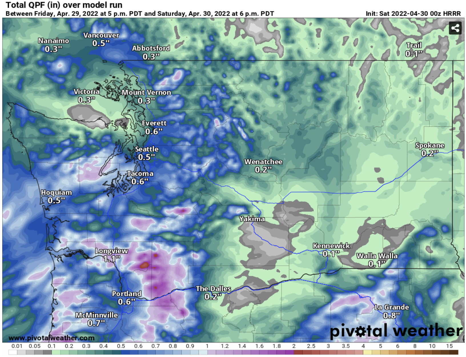
Expect 0.4 to 0.8 inches through Saturday for areas Everett southward, in the foothills, mountains, and on the coast. North of Everett, 0.2 to 0.4 inches are expected, with a rain shadow over the Sequim/Port Angeles areas. The most rain from this system will fall over the Southern WA Cascades and SW Washington, near Longview/Kelso. 0.8 to 2 inches of rain is expected in this area.

Another round of rain will move in very late Sunday night through Monday morning. This round will be lighter than the Friday/Saturday rain, likely totaling between 0.2 and 0.4 inches around the area. 

In another sign of spring, there is much less mountain snow falling. As seen in the HRRR forecast below for snow over the weekend, snow is now relegated to the higher elevations, generally 4,500-6,000 feet or higher. 


Temperatures are getting warmer, with more days as of late having highs in the upper 50s to low 60s. Case in point is the GEFS (ensemble version of the GFS model) forecast for next Wednesday, seen below. 


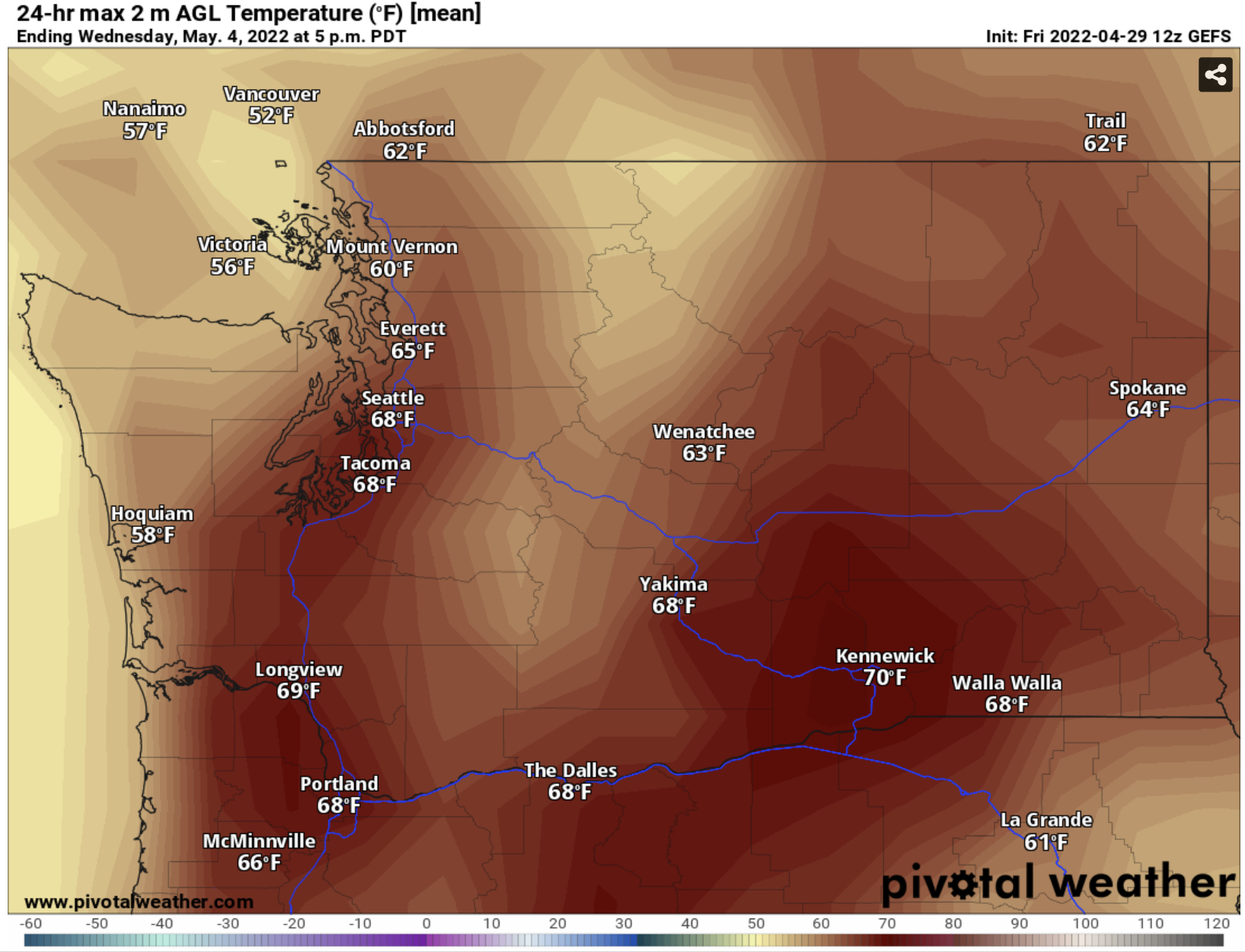
Most forecast models agree that Wednesday will be a nice and spring-like day, with highs in the upper 60s to low 70s! Eastern Washington, Southwest Washington, and the Willamette Valley will likely be in the low to mid 70s! 

Despite a cold start that even featured snow, conditions are warming up, and spring has definitely arrived here in the Pacific Northwest!

Wednesday, April 27, 2022

Next Round of Rain Ahead, Most From Seattle Southward

FastCast—Thursday, Apr. 28 to Monday, May 2:

The next round of rain is on the way for Western Washington. Before it arrives, expect mostly cloudy and dry weather on Thursday, through Friday evening. Rain arrives Friday evening, continuing at times through Saturday afternoon, then a break from late Saturday through Sunday afternoon. Rain will begin again late Sunday, continuing through midday Monday. Expect rain by Monday evening to total 0.5 to 1.4 inches south of Seattle and on the coast. Totals will range from 0.2 to 0.7 inches north of Seattle. Expect highs in the mid 50s to low 60s and lows in the mid to upper 40s.

———————————————————

Continue reading the full blog below!

The next round of rain will arrive Western Washington late Friday night, continuing a wetter than normal spring during this La Niña pattern. 

The European model forecast for rain through Monday evening (May 2nd, 5 PM) is below.


This will be a wet end to April/start to May. Expect the most rain to fall from late Friday to Saturday morning and again from Sunday evening to Monday morning. Totals will decrease the further north you go. South of Seattle and on the coast, expect 0.5-1.4 inches. North of Seattle, 0.2 to 0.7 inches will fall. From Chehalis southward, expect 1.5 to 2.5 inches, most in the North Oregon and South Washington Cascades. Eastern Washington will receive 0.15 to 0.4 inches, helping with some drought relief.

Temperatures continue to be near average, and warmer than earlier this month, with highs in the mid 50s to low 60s, and lows increasing to the mid to upper 40s.

————————————————————
International Weather Feature:

While the 2021 Pacific Northwest Heat Wave was very bad, be thankful that we are not experiencing the conditions in India right now. Take a look at the European model high temperatures for Asia (in Celsius).


The entire Indian subcontinent is being baked by high temperatures of up to 111 degrees, lasting for days on end. Lows only reach the mid 80s. Sometimes this heat is occurs in the United States, but it occurring in a developing country with horrible air quality is much worse. 

———————————————————
Southwest US Wildfires Information:

Sunday, April 24, 2022

Rain Returns After A Beautiful Weekend

 FastCast—Monday, Apr. 25 to Thursday, Apr. 28:

After a beautiful weekend, with highs in the low 60s on Saturday and the upper 60s to low 70s on Sunday, rain will return to the region to begin the work week. Showers are moving onshore Sunday evening, with showers at times through Wednesday. Expect these showers to total 0.2 to 0.5 inches in the lowlands (in a slight rain shadow) and 0.7 to 1.5 inches in the foothills, north of Everett, and on the coast. Temperatures will cool significantly from their Sunday highs. Expect highs in the low to mid 50s and lows in the upper 30s to low 40s from Monday to Thursday.

————————————————————

Continue reading the full blog below!

What a beautiful weekend! This weekend was a nice break between rainy/showery periods in Western Washington. Sunday’s highs around the interior lowlands are below.


Highs reached the upper 60s to low 70s, the warmest day since April 7th! 

Unfortunately, no days above the low 60s are expected for the next week. Rain showers return overnight Sunday, remaining through Wednesday. The European model forecast for rain through early Thursday is below.


Expect 0.2 to 0.5 inches of rain in the lowlands (which will be in a partial rain shadow) and 0.7 to 1.5 inches in the mountains, north of Everett, south of Olympia, and on the coast. 

So far, this spring has generally been below normal temperature-wise (with the exception of a few nice days), and that trend will continue to start May. Take a look at the NWS Climate Prediction Center temperature outlook for April 30 to May 4.

It is likely that below-average temperatures will continue to start May. However, the bright side is that while temperatures are below average, they are still increasing, and highs above 55° are much more likely in May than in April during these below average setups. The overall pattern above shows a classic La Niña setup, with below average temperatures over the entire Northern US, and much above average temperatures in the South and parts of the Southwest & Plains.

——————————————————
Find information about the upcoming Northwest Weather Workshop (May 7th, Zoom meeting) below:


This is a very informative & educational meeting of Pacific Northwest weather enthusiasts, and I highly recommend registering for the free meeting!

Thursday, April 21, 2022

Mostly Dry & Warmer Weekend Ahead

FastCast—Friday, Apr. 22 to Tuesday, Apr. 26:

After a few showery and cooler days, a couple nicer days are ahead for Western Washington! Expect partly sunny days on Friday and Saturday, with highs in the upper 50s to low 60s and lows in the upper 30s to low 40s. Sunday will begin partly sunny, with highs reaching the low 60s, before clouds increase in the afternoon. Showers return for Sunday evening to late Tuesday. Expect 0.3 to 0.8 inches of rain around the lowlands by Wednesday morning. Expect Monday’s highs in the upper 50s, with lows in the low 40s. Highs on Tuesday and Wednesday will be cooler, in the low to mid 50s, with lows in the upper 30s to low 40s.

—————————————————————

Continue reading the full blog below!

A couple nicer days are ahead for Western Washington, including a mostly dry weekend! Temperatures will climb to near average after a string of colder days. Saturday’s highs are below, from the European model.


Expect similar highs on Friday and Sunday as well. A nice few days, with highs in the upper 50s to low 60s for the lowlands, are ahead!

However, it will not be long before rain returns. Clouds increase Sunday afternoon, with showers arriving Sunday evening to Monday morning, likely lasting through Wednesday. Below are the expected rain totals through Wednesday evening from the GFS model.


Totals are expected to be highest on the coast and north of Everett (0.5 to 1.5 inches), and around 0.2 to 0.5 inches in the lowlands. This is a more typical spring pattern for the Pacific Northwest. However, highs will be a bit cooler to start next week, dipping to the low 50s on Tuesday.

Enjoy the nicer weather for Friday, Saturday, and most of Sunday!

Tuesday, April 19, 2022

Potential for Severe Thunderstorms in Western Oregon

 FastCast—Wednesday, Apr. 20 to Sunday, Apr. 24:

An interesting cold front will approach the Pacific Northwest on Wednesday. This front will bring rain, breezy conditions, and a chance of thunderstorms to the region. The biggest weather headline is a “marginal” risk of severe thunderstorms in Western Oregon and extreme SW Washington. This marginal risk area (designated by the NWS Storm Prediction Center) includes a threat of winds 60+ mph, brief severe hail, and a slight chance of a weak tornado. For the rest of the region, expect a chance of non-severe thunderstorms, especially on Wednesday afternoon and evening. More showers can be expected on Thursday, with 0.2-0.5” possible by Thursday evening in the lowlands. Expect highs in the low to mid 50s and lows in the upper 30s to low 40s through Thursday. Friday and Saturday bring a brief ridge and warmer weather, with highs in the upper 50s to low 60s and partly sunny conditions! Light showers return late on Sunday, but highs will still be in the upper 50s to low 60s, with partly sunny conditions.

———————————————————

Continue reading the full blog below!

An interesting weather day is ahead for the Pacific Northwest on Wednesday. Due to a cold front moving in with unstable air in place…there is a “marginal” chance of severe thunderstorms in Western Oregon. The NWS Storm Prediction Center (SPC) graphic below shows the risk area (dark green).


This risk area includes the entire Oregon Coast, Coast Range, and most of the Willamette Valley, including Salem, Eugene, and areas around Portland. Extreme SW Washington is also included in the risk area.

What does a “marginal” risk mean? Take a look at the SPC graphic below that explains severe thunderstorm risk categories.


Despite being the lowest category of severe thunderstorms, a marginal risk is still notable for the Pacific Northwest.

The HRRR forecast below for Wednesday afternoon shows CAPE (Convective Available Potential Energy), another way of saying the amount of instability in the atmosphere.


Notice the gray shading over parts of the Pacific Northwest. This indicates CAPE values of approximately 250-700, notable for our region (but laughable for other parts of the country). 

Note that there is a chance of thunderstorms for Western Washington as well, particularly in the afternoon as the front moves through. However, storms in Western Washington are not expected to reach severe status (except a slight chance in extreme SW Washington, including parts of Wahkiakum and Pacific Counties, and the southern half of the Long Beach Peninsula).

Back in Western Oregon, there is also a slight chance of weak tornadoes. The SPC indicates a 2% chance of a tornado for Western Oregon.


This is a slight chance, and any tornado or waterspout will be short-lived and on the weak side. There is also a slight chance (5%) of damaging thunderstorm winds (58+ mph gusts) and severe hail (1” or greater diameter) in the marginal risk area. However, these are will also be short-lived if they occur. 

The best chance for thunderstorms around the Pacific Northwest will be in the afternoon to evening on Wednesday. Stay tuned to our local meteorologists on Twitter, the SPC, and Michael Snyder’s Pacific Northwest Weather Watch YouTube channel for updates!

Sunday, April 17, 2022

Rainy Pattern Returns This Week

FastCast—Monday, Apr. 18 to Friday, Apr. 22:

After a beautiful Easter Sunday, with highs in the upper 50s to low 60s and mostly sunny skies, a rainy pattern is ahead for the next week. Expect a system to move in on Monday, bringing rain at times and a period of gusty winds (up to 30-35 mph) on Monday evening as a front moves through. Scattered showers (and possible thunderstorms) are possible on Tuesday and Wednesday. Rain through Wednesday will total 0.75 to 1.4 inches around the lowlands, with less in the traditional rain shadow and more on the coast. Additionally, expect 6-12 inches of snow in the passes through Wednesday (likely less at Snoqualmie Pass). Showers will continue on Thursday and Friday, totaling around another 0.2-0.3 inches for the lowlands and a couple more inches of snow in the mountains. The good news is that the trough has moved offshore…and this brings rain instead of much colder temperatures. Expect highs in the low to mid 50s (possibly into the upper 50s), and lows in the upper 30s to low 40s. Overall, a bit warmer than last week, with no highs below 50 degrees…but much rainier. Stay tuned!

————————————————————

Continue reading the full blog below!

After a beautiful and near-average temperature Easter Sunday, a week of rain is in the forecast. Below is the European model forecast for rain through Wednesday.


Expect 0.75 to 1.4 inches in the lowlands through Wednesday, with the most falling on Monday. The coast will receive 1.5 to 2.5 inches, and the traditional rain shadow will receive less than the surrounding areas. Eastern Washington will also receive 0.2 to 0.4 inches, and anything helps for drought relief!

Monday’s system will also bring a brief period of gusty winds in the afternoon and evening due to the cold front moving through. Expect winds to gust up to 30-35 mph, and up to 40 mph near the water and on the coast.

As temperatures are still below normal, snow levels will remain lower than average for April, allowing the snowpack to increase. The European model forecast below shows expected snowfall through Wednesday.


Expect 6-12 inches in the passes (less at Snoqualmie Pass) through Wednesday. Higher elevations will likely pick up 1-2 feet! This April snow is critical to keep Washington’s mountains at average snowpack entering the summer.

The best impact of the upcoming pattern will be the increased rain in Southern Oregon and Northern California. The US Drought Monitor map from April 14th (below) shows that these areas are still in extreme drought conditions. (Note that exceptional drought…dark red…still exists in Eastern Oregon).


These drought conditions in S. OR and NorCal haven’t been helped by the La Niña winter conditions, which favor Western Washington and NW Oregon with more precipitation, and bring much drier conditions to Southern Oregon and Northern California.

Now…for the upcoming precipitation (through Thursday), take a look at the European model below.


Southern Oregon and Northern California receive 1 to 4.5 inches of rain…very good for drought relief! The Northern Sierra Nevada will also pick up some snow!

Thursday, April 14, 2022

Cold Mornings Through Saturday, Rainy Pattern Next Week

 FastCast—Friday, Apr. 15 to Monday, Apr. 18:

After freezing temperatures, some lowland snow, and spotty showers on Thursday, a drier day is expected on Friday. Some scattered showers are possible, with rain/snow mix possible in the morning. More showers are possible on Saturday, again with rain/snow mix possible in the morning. Highs on Friday and Saturday will be in the upper 40s to low 50s, with lows in the low to mid 30s. Sunday (Easter) will be much warmer, with highs in the upper 50s, and lows in the low to mid 40s. Partly sunny conditions are expected on Easter, with increasing afternoon/evening clouds. On Monday, a much wetter pattern will begin. Expect 0.4 to 0.8 inches of rain on Monday, with cooler weather as well (highs in the upper 40s to low 50s). Expect this rainy pattern to continue through at least Wednesday of next week. Stay tuned!

—————————————————————

Continue reading the full blog below!

After a day that began with freezing temperatures and lowland snow, a drier day is ahead on Friday. Some showers follow on Saturday, but less total rain than this week. See the NAM forecast below through 5 AM Sunday.


0.1 to 0.2 inches can be expected area-wide, with much more (up to 1” total) possible in heavier showers. Mountain snow (3-8”) is possible at the passes over the weekend as well.

Expect a few more cold April mornings from Friday to Sunday, with lows in the low to mid 30s. Some frost is possible.

A much rainier pattern begins next week. Below is the European model forecast for rain through Thursday morning.


It looks like 1.5 to 2 inches of rain will fall in the lowlands next week. More is expected on the coast (2.5-5 inches). Significant rain will also fall in Eastern Washington (0.3 to 0.75”), making a small dent in drought conditions.

As this much colder than average pattern continues, substantial mountain snow will also continue. The European model forecast for snow through Thursday is below.


Expect significant mountain snow, with 12-18 inches at Snoqualmie Pass, and 18-30 inches at Stevens and White Passes. After the snowpack started dipping below normal in February and March, this April cold pattern is bringing the snowpack back toward normal levels.

Looking ahead, below normal temperatures are expected to continue for April 22 to 28. The NWS Climate Prediction Center graphic is below.


Much of the West will experience below average temperatures for the rest of April. This is a characteristic of the La Niña conditions that will continue this spring.

Tuesday, April 12, 2022

Crazy Spring Weather Around the Western US

FastCast—Wednesday, Apr. 13 to Sunday, Apr. 17:

Winter-like weather continues in Western Washington, with chilly temperatures expected, although showers will decrease. Expect light rain/mountain snow at times through Friday. Temperatures will be noticeably chilly for April. Expect highs in the low to mid 50s, and cold lows in the low to mid 30s. Lows will be near or below freezing on Wednesday and Thursday mornings. Conditions will be partly to mostly cloudy. A system will bring rain on Saturday, then temperatures warm to the upper 50s on Sunday. A wetter pattern looks to be in store for next week, with temperatures slightly below normal (better than this week’s substantially below normal temperatures)!

———————————————————

Continue reading the full blog below!

“Abnormal” is the correct word to describe the recent spring weather across most of the Western and Northern United States in recent days. 

Starting in the Pacific Northwest, SW Washington and NW Oregon were hit with a historic April snowstorm on Monday, leaving traffic chaos, roads closed, and even some downed trees and power outages. Snow totals varied substantially, with a peak of nearly 10-12 inches in the foothills of Oregon’s Coast Range (West Portland) and in Washington Southern Cascade foothills, including Washougal, seen in the WSDOT camera image below from 7:50 AM Monday.


Vancouver and Ridgefield, WA both received 4-7 inches, and the Portland metropolitan area received 1-3 inches, with even more in Portland’s higher hills.

(Note: A weak system may bring up to 1-3 inches of additional snow to the Portland/Vancouver and SW WA region in the early morning hours on Wednesday)

On Tuesday, residents of parts of the Puget Sound lowlands were surprised with rare April snow flurries, including in parts of the Seattle-Tacoma metro area, seen below in WSDOT’s 38th Street camera in Tacoma (at 2:55 PM).


This snow didn’t amount to much more than a brief accumulation on grassy surfaces.

What is the cause of the overall “winter-like” pattern?

Generally, it is a massive trough over the entire Western US, bringing much colder weather across a wide area. These patterns are also conducive to an open door for weather systems. The trough can be seen below (purple and blue) on the European model.


Because of this trough, weather systems approach the Pacific Northwest from a northwesterly direction, instead of from the S-SW as usual. A different approach direction for the weather systems brings colder air from Canada and Alaska, instead of warmer air from across the Pacific Ocean.

In addition to colder temperatures across the entire Western US (even below 60° in Phoenix on Tuesday morning), this pattern is producing an utterly insane spring blizzard in North Dakota.

The European model below shows snow totals through early Friday in North Dakota.


These are mind-boggling snow totals considering that it is April. The city of Minot will likely receive over 30 inches of snow!

In addition, it will be very windy, as seen in the European model below for winds overnight Wednesday into Thursday.


Winds will gust 45-55 mph in addition to 12-36 inches of snow. This is a full-on blizzard…in spring!

While North Dakota is the spring snow epicenter…take a look at the expanse of the northern tier of the United States that will receive snow in the next few days!


This is the definition of a cold troughing pattern…more like winter than spring!

Sunday, April 10, 2022

April Winter Storm Impacting the Pacific Northwest

 FastCast—Monday, Apr. 11 to Thursday, Apr. 14:

A rare April winter storm is impacting the Pacific Northwest. Sunday was a day of showers (some quite heavy, including snow and hail) in the lowlands and significant snow in the mountains. As of Sunday night, a storm system is moving into the Oregon Coast. This system is too far south to bring lowland snow to the Puget Sound area (slight chance of rain/snow mix). However, due to easterly and northeasterly winds being drawn out of the Cascades by this system, there is a chance of snow on the Northern Olympic Peninsula and in the Hood Canal area. From roughly Olympia southward, snow is expected on Monday morning, due to a band of snow to the north of the low center. Areas from Olympia to just south of Portland will likely receive 1-3 inches of snow. In the lowlands, expect a mostly cloudy day with breezy northerly winds at times. Expect showers at times from Monday to Thursday, with highs in the mid 40s to low 50s, and lows in the low to mid 30s. 

—————————————————————

Continue reading the full blog below!

A rare April winter storm is bringing a mix of impacts to the Pacific Northwest. Significant snow fell in the mountains today due to a small “meso-low” that moved through the Puget Sound area on Sunday. The photo below from Gunner Hicks shows snow in the Snoqualmie Pass area.


Significant impacts (including a Saturday closure) were observed at Snoqualmie Pass, with chains required for the majority of the morning on Sunday.

Looking ahead, the main weather maker for Monday will be a compact low center making landfall on the Oregon Coast overnight Sunday into Monday, seen below (red box) on the UW model.


This storm will bring snow to areas between Olympia and the Portland metro area. Below is the high-resolution HRRR model, showing snow through Monday evening (most will fall Monday morning).


The HRRR shows snow mainly staying south of Chehalis. Big amounts in Longview and Portland are likely overdone, and will most likely be around 1-3 inches, perhaps higher above 500 feet.

The NAM model has the same general forecast, seen below through Monday evening.


The NAM brings snow a bit further north, toward Tumwater. Both forecasts also bring some snow to parts of Eastern Washington, even low elevations in the Columbia Basin. Both models also likely overdo snow around Longview.

The HRRR and NAM agree that the Willapa Hills of Washington and Northern Coast Range of Oregon will receive a significant winter storm, with totals of 6-18 inches possible, especially above 2,000 feet. Be prepared for winter travel conditions in these areas, and on White Pass (US-12) in Washington, which will receive up to a foot of snow.

This storm is too far south for snow over the lowlands of Western Washington to get snow, but it will bring occasional breezy conditions as the storm draws winds out of the Cascades. 

Below is a map from NWS Seattle summing up the snow situation for Western Washington.


This pattern is quite a rare one for April…and some odd weather for spring is expected. Stay tuned!

Friday, April 8, 2022

Is Lowland Snow Possible This Weekend?

FastCast—Saturday, Apr. 9 to Tuesday, Apr. 12:

After a very warm day on Thursday (highs 67-78 degrees), we have plunged 20 to 30 degrees as a much colder pattern arrives across the Pacific Northwest. Friday was showery with scattered heavy showers and gusty winds at times (30-40 mph). More showers and isolated thunderstorms are possible on Saturday. Persistent Convergence Zone bands may bring rain to parts of the Central Sound, but their main impact will be heavy, localized snow at times in the Central Cascades. Expect this localized heavy snow (rates of 1-2” per hour) to last through Saturday evening. Accumulations of 6-14” are possible under these bands (Snoqualmie and Stevens are the passes that may be impacted). A weak system will move SE across the area on Sunday morning, and with temperatures in the low to mid 30s, brief lowland snow is possible. Rain/snow mix is the most likely probability, but snow showers are possible on Sunday morning, especially on higher hills. (Read below for more information). Additional systems are expected in the next few days, as the troughing pattern over the Pacific Northwest ushers in more systems. For the next few days, expect highs in the upper 40s to low 50s, and lows in the low to mid 30s.

————————————————————

Continue reading the full blog below!

Is lowland snow really possible this weekend? This blog will attempt to answer the question.

Generally, the odds are stacked against lowland snow. By this time of year, it is hard for temperatures west of the Cascades to drop below freezing, the sun is much too strong, and it is harder to get lowland snow-producing patterns in springtime. 

However…it’s not impossible. When the correct conditions line up, springtime lowland snow can happen.

Let’s take a look at the high-resolution HRRR forecast for snowfall through Sunday evening. 


It does show light lowland snowfall (not necessarily what will actually accumulate, should snow happen)

The high-resolution NAM model (below) is in agreement as well, though it shows a more localized snowfall scenario.


The NAM’s forecast predicts a localized snow band setting up between Seattle and Tacoma on Sunday morning, vs. the HRRR, which suggests a more widespread (but brief) band of snow on Sunday morning.

While these models show some snowfall, we know in Western Washington that we have to look deeper than just how much snow the model says will fall. 

Let’s take a look at temperatures on Sunday morning. The HRRR is below.


Temperatures over the lowlands are quite marginal, in the mid to upper 30s. The only way snow could fall in this situation would be if precipitation is heavy enough…because that will lower snow levels briefly, and also drop temperatures a few degrees.

The NAM also shows marginal temperatures, seen below.


There is a caveat with the NAM’s prediction. Notice that inside the red box I added to the forecast, the green is a shade darker. This represents colder temperatures (34-35 degrees). These colder temperatures line up with where the NAM predicted a snow band. 

Checking one more forecast…the UW model also shows lowland snowfall, but from approximately Seattle northward, as it takes Sunday’s system on a more northerly track than the HRRR or NAM models.


The UW forecast also shows that temperatures will be quite marginal (seen below).


Temperatures on Sunday morning are in the 34 to 38 degree range around the lowlands. 

Taking all this into consideration, brief snow accumulations are most likely for those on hills above 1,000 feet on Sunday morning. Areas 500-1,000 feet have a potential for spotty accumulations, but most likely rain/snow mix. Those below 500 feet will most likely see cold rain or brief rain/snow mix.

As we know in Western Washington, surprises can happen, and it only takes a couple degrees of cooling for snow to fall…so don’t rule out brief lowland snow on Sunday, but it looks to be quite a marginal setup.

Stay tuned to our local meteorologists on Twitter and Michael Snyder’s Pacific Northwest Weather Watch YouTube channel for more information!

Tuesday, April 5, 2022

Temperature Roller Coaster Ahead: Freezing to Near 70, Then Far Below Normal

 FastCast—Wednesday, Apr. 6 to Sunday, Apr. 10:

After a significant spring storm, an interesting period of weather is ahead. Expect a chilly morning on Wednesday, with lows in the low 30s and frost possible around the region. Expect partly cloudy conditions on Wednesday and Thursday, with Wednesday highs in the upper 50s to low 60s (lows in the upper 30s to low 40s). Thursday will be the warmest day of 2022 so far, with highs in the upper 60s to low 70s, and lows in the low to mid 40s. A significant pattern change begins on Friday. From Friday onwards, strong troughing will bring consistent showers and far below average temperatures. Expect highs in the upper 40s to low 50s, and lows in the mid 30s. These temperatures will be comparable to late February/early March, and will be around 5 degrees below average. Expect 0.1 to 0.3” of showers in the lowlands (likely rainshadowed) on Friday and Saturday, with 0.75 to 1.5 inches north of Everett, in the foothills, and on the coast. 

——————————————————

Continue reading the full blog below!

A roller coaster of temperatures is ahead for Western Washington! Let’s start with low temperatures on Wednesday morning, seen in the European model forecast below.


Expect lows near or just below freezing across the lowlands, even into the upper 20s in some outlying areas. Places near the water will only get to the mid 30s. Be prepared for frost…especially if you have outdoor plants.

Patchy fog is possible on Wednesday morning, before clearing to a partly sunny day, with highs in the upper 50s to low 60s. Then, the warmest day of the year so far is expected on Thursday…due to a strong high pressure ridge over the area. Below is the European model forecast for Thursday’s highs.


High temperatures will reach the upper 60s to low 70s in the lowlands! The Willamette Valley will even get to the mid 70s! 

We will have to enjoy this warmth while it lasts…as the ridge will be replaced by a very dominant troughing pattern that will bring much colder temperatures, with highs only reaching the upper 40s to low 50s, and lows consistently in the 30s. 

In the European model forecast below (for next Tuesday), the troughing is evident (pink, purple, and dark blue) over the Western US.


What will this bring? Significantly below average temperatures (more reminiscent of late February & early March) and an open door for weather systems.

The NWS Climate Prediction Center outlook below shows expected departure from average temperatures for April 11-15.


Western Washington has a 60-80% chance of below average temperatures, a probability usually seen in winter. Also, notice how the areas of below average temperatures and areas of troughing on the forecast model are nearly the same!

This kind of troughing pattern gives an open door for weather systems to enter Western Washington. It is likely that the overall pattern will be active, but the exact details are still uncertain. With colder temperatures expected, some forecasts have shown rain/snow mix or some snowflakes next week…take this with a grain of salt, as it is much too uncertain as of now.

Spring Windstorm Recap:

Forecasts were generally accurate for winds on Monday. Peak winds were 40-50 mph in the metro area, 50-70 mph in the North Sound and on the coast, 55-70 mph in Eastern Washington, and 75-125 mph in the mountains. Below are some zoomed in maps of peak wind gusts on Monday around the region.


Sunday, April 3, 2022

Sunday Night Storm Update

A strong spring storm is moving into the Pacific Northwest, bringing strong winds, heavy mountain snow, and heavy rain. 

Let’s take a look at the latest wind forecasts (as of 9 PM Sunday). The first burst of winds will accompany the frontal passage, between 12 and 3 AM Monday. The high resolution HRRR model forecast below shows predicted wind gusts at 3 AM Monday.


Winds gusting 40-50 mph in the lowlands and 45-60 mph on the coast and in the Northwest Interior will accompany the frontal passage. There will be a slight lull in the winds from early Monday morning through midday, before winds pick up again in the afternoon.

The European model forecast below shows peak gusts on Monday afternoon & evening.


Expect gusts of 40-50 mph in the lowlands and 50-60 mph on the coast and in the Northwest Interior. Eastern Washington will experience gusts of 50-65 mph. 

These winds, which will last for 12-24 hours in some locations, will likely bring tree damage and isolated power outages to Western Washington, and those same hazards plus blowing dust in Eastern Washington.

Due to these winds, a Wind Advisory has been issued for the lowlands from 12 AM to 8 PM Monday, and High Wind Warnings are in effect for the WA & OR coasts, the North Sound, and Eastern WA & OR. All these alerts (plus Winter Storm Warnings) create a colorful NWS Seattle map…viewed below. 


If you click here, you can view the information in each alert on the NWS Seattle website by clicking the alert’s name.

Another major impact of this storm will be significant mountain snow. Below is the NWS Seattle forecast for snow through Tuesday morning.


Expect lesser amounts of snow at Snoqualmie Pass, and significant amounts of 18-24 inches at Stevens and White Passes, and even more (30-48”) at higher elevations, such as Paradise and Hurricane Ridge. Snow levels will rapidly fall with the frontal passage early Monday morning, dropping to around 2,000 feet. Additionally, winds gusting 30-45 mph at times will bring areas of low visibility and blowing snow to the passes. 

This storm will also bring rain (heavy at times) to Western Washington. The high resolution NAM model forecast is below, showing rain expected with this storm.


Expect 0.4 to 1 inch of rain around the lowlands, with more (1.5-3”) on the coast and from Olympia southward (1-2”). 

There is also a chance of thunderstorms on Monday, due to an unstable atmosphere behind the cold front. The UW model below shows instability (CAPE index) on Monday afternoon.


CAPE instability values of 100-400 are expected for Western Washington, decent for April. Expect widespread showers on Monday, with the threats of heavy rain, hail, and thunder & lightning in any shower.

One final note…expect 16-25 foot swells on the Pacific Northwest Coast from midday Monday through Tuesday evening. These are large waves, especially for this time of year. Stay safe on the beaches!

Stay tuned to our local meteorologists on Twitter for updates, and stay safe!

Short Spring Heat Wave for the Pacific Northwest

  FastCast--Thursday, May 9 to Tuesday, May 14: A spring "heat wave" is ahead for the Northwest, with the warmest temperatures see...