Thursday, September 28, 2023

Calm Weekend & Start to October Ahead

FastCast--Friday, Sep. 29 to Tuesday, Oct. 3:

After most of Western Washington received triple September's average rainfall in under one week, conditions will calm down to end the month and begin October. On Friday, Saturday, and Sunday, expect partly cloudy to mostly sunny conditions (sunniest on the weekend), with lowland highs in the low to mid 60s and lows in the mid 40s, except in the low 40s in some outlying areas. Clouds and showers will return on Monday, with a chance of showers (likely 0.1-0.3") and highs dipping to the upper 50s, with lows in the upper 40s. Mostly cloudy conditions look to persist on Tuesday, with highs in the upper 50s to low 60s, and lows in the upper 40s to low 50s. Scroll to the bottom of the blog to see rain amounts for the past few days (spoiler: they're impressive!).

------------------------------------------------------------

Continue reading the full blog below!

After a very rainy and stormy stretch, much calmer weather is in store to end September and begin October. Let's take a look at the forecast!

We'll start below with the European model's forecast for highs on Friday.


On Friday, expect a cool day, with highs across the state in the upper 50s to low 60s, except along the Strait of Juan de Fuca, where highs will remain in the mid 50s. Mountain towns will remain in the low to mid 50s, and the Willamette Valley will reach the low to mid 60s.

Next, let's take a look at Saturday's highs, seen below, also from the European model.


On Saturday, temperatures will climb a bit, with lowland highs in the upper 50s to low 60s, Willamette Valley highs in the mid to upper 60s, and Eastern Washington reaching the upper 50s (near Spokane) to low 70s (in the Columbia Basin). The coast will remain in the upper 50s.

Next, the highs for Sunday, seen below from the European model.


We'll likely warm up more on Sunday. Lowland highs are expected to reach the low to mid 60s, with the Willamette Valley reaching the upper 60s to low 70s, Eastern Washington reaching the mid 60s to mid 70s, and the coast increasing a bit to the upper 50s to low 60s.

What about morning lows? Sunday will likely be the coolest morning of the next few. Below are Sunday morning's lows from the European model.


Expect a chilly morning on Sunday. The lowlands will likely dip to the low to mid 40s, with the Willamette Valley and Eastern Washington dipping to similar low temperatures. The coast and areas near the water will drop to the mid 40s to low 50s. In mountain towns and mountain valleys & foothills, temperatures will likely drop to the upper 30s to low 40s...a sure sign of fall!

Let's end by taking a look at how much rain the region received since Saturday, September 23rd!


A few things to notice here...the lowlands received 1.4-3.5 inches on average, with some areas getting even more. September's monthly average is 1.61" in Seattle, to put it in perspective. The Olympic Mountains were the regional winners, with some stations getting up to 9" of rain! Also, notice the very obvious rain shadow NE of the Olympics. While the southern slopes get 4-8", the northern Olympic Peninsula, San Juans, and Island County got a meager 0.05-0.75", showing the extraordinary rain differences over a small area!

Areas with active wildfires in the Olympics and Cascades received 2.5-6" of rain, effectively ending stopping wildfire season in its tracks!

Enjoy the calm & relatively seasonable weather ahead!

Tuesday, September 26, 2023

Rapidly-Developing Storm Bringing Strong Winds & More Rain to Western Washington

Update 8:50 AM Wednesday: This storm tracked further south than models showed at the original writing of this blog. Impacts for the metro area will be limited to heavy rain and a Convergence Zone north of Seattle Wednesday afternoon. Areas from Tacoma southward could see winds gusting up to 30-35 mph at times, but most wind impacts have been relegated to the coast.

-------------------------------------------------------------------

No FastCast tonight...continue reading the full blog below for an update on the incoming storm.

A fast-developing storm system is moving toward Western Washington, and it will bring strong winds and heavy rain on Wednesday.

Below is a satellite image of the storm at 9:45 PM Tuesday from the GOES-18 satellite (watch satellite loop here).


The storm center is offshore of the mouth of the Columbia River, and the storm is moving northeast. Landfall of the storm center will likely be on the North-Central Washington coast, between Ocean Shores and La Push.

Here is another view of the storm from the satellite viewer tool on weathernerds.org.


Notice all the recorded lightning strikes near the storm center, as it continues to intensify as it moves in. Over 100 strikes have been detected tonight.

This storm will likely bring a good punch of strong winds to the region on Wednesday. Let's take a look at some forecasts for wind gusts, starting with the European model, showing gusts at 11 AM Wednesday.


This model forecasts in knots, so gusts in miles per hour will be higher than what's shown. Generally, expect gusts from Seattle southward to reach 35-45 mph, strongest from Sea-Tac south to Chehalis. North of Seattle and on the Kitsap Peninsula, gusts will reach 25-35 mph, except 35-40 mph near the water, mainly along Admiralty Inlet. The coast will gust 40-50 mph, mainly from Moclips/Seabrook south toward Astoria. Isolated coastal areas could briefly gust up to 50-60 mph, especially on the northern Long Beach Peninsula.

Next, let's compare this to the NAM high-resolution model, showing gusts at 9 AM Wednesday.


The NAM shows gusts from Seattle south of 30-40 mph, except 40-45 mph from Federal Way south toward Grand Mound. The coast will gust 40-50 mph, but mainly in Pacific County in this forecast.

Before we take a look at some rain & low pressure graphics, we'll finish looking at wind forecasts with a slightly different graphic. This is the high-resolution HRRR forecast showing peak gusts for the entire event, not just a specific time.


The HRRR shows the entirety of the lowlands reaching 35-45 mph, with areas from Tacoma to Everett reaching 40-45 mph, along with areas near the water from Whidbey Island northward. This forecast shows the immediate coast gusting 40-50 mph, with gusts over 60 mph just offshore.

It is important to note that due to trees being fully loaded, recent heavy rainfall, and trees being weakened by persistent dry weather this summer, there is a higher potential for tree damage and power outages with this storm. In late fall and winter months, this would be a somewhat garden variety storm, but the first wind event of the season usually causes more impacts than others.

Now, let's take a look at rain forecasts through Wednesday night, starting with the European ensemble (EPS) forecast, seen below.


This does factor in Tuesday's rain, so expected new precipitation on Wednesday in this forecast is 0.5-1" in the lowlands and on the coast.

Next is the GFS rain forecast, also showing total rain through Wednesday night.


The GFS forecast shows 0.8-1" of new rain for the lowlands and parts of the coast, with less rainfall from Everett northward due to a broad rainshadow.

Finally, the NAM high-resolution rain forecast through Wednesday night, seen below.


This forecast shows rain being a lot more hit-or-miss, with a Convergence Zone from Shoreline to Seattle bringing 0.8-1.2", and the rest of the lowlands (except the NE Olympic rainshadow) get 0.3-0.5". The coast will pick up an additional 0.7-1.4" in this forecast.

Overall, a quick storm with potential for some impacts is ahead. Again, this storm's main impacts will be potential tree damage & power outages and another round of standing water & ponding on area roads. Standing water could be much more widespread with wind blowing leaves off trees and clogging up storm drains.

Stay safe, stay aware, and enjoy the beginning of our storm season!

Monday, September 25, 2023

More Storms Take Aim at Western Washington

FastCast--Tuesday, Sep. 26 to Thursday, Sep. 28:

After an atmospheric river brought 0.5-1.5" of rain to most of Western Washington from Sunday to Monday, another couple storms are ahead. The next system takes aim on Tuesday, bringing more heavy rain (0.25-0.5" for the lowlands) and winds gusting 25-35 mph at times. There is also a chance of isolated thunderstorms, so if you are under a heavy shower, be prepared for possible thunder & lightning. A more complicated system arrives early Wednesday morning. The system, a compact area of low pressure, will pack strong winds and heavy rain, but will be far more impactful on its south side. However, there is significant disagreement in the forecast models about where this storm will make landfall on the coast. Forecasts range from the Northern Olympic Peninsula to the Northern Oregon Coast, giving a huge range of potential impacts. Should this storm move closer to the lowlands, it will likely bring another 0.5-1.5" of rain and potentially stronger winds. Stay tuned to Tuesday night's blog for more details. Another system will likely move through on Thursday, bringing another round of rain. Through Thursday, expect highs in the upper 50s to low 60s, with lows in the mid 40s to low 50s. 

----------------------------------------------------------

Continue reading the full blog below!

As the atmospheric river and associated cold front & heavy showers move out of Western Washington, more storms are ready to take aim at our region. Let's take a look at the forecast!

We'll start with the European Ensemble forecast (EPS) showing total rain through Tuesday night.


Note...this forecast does include rain that fell on Monday. The estimated new rainfall on Tuesday in this forecast is 0.5-1", which is on the higher end of potential solutions. The coast will get a similar amount of new rainfall. However, Eastern Washington will likely pick up 0.1-0.5" of rain on Tuesday, their first widespread rain of the season. 

Let's compare this to the GFS forecast, also showing total rain through Tuesday night.


The GFS shows 0.5-0.8" of rain on Tuesday from Olympia to Everett, with other areas in the lowlands getting 0.1-0.4". The coast will pick up 0.4-0.6" in this forecast, with Eastern Washington (mainly the eastern third) getting 0.2-0.5". 

Yet another system (a much more complex storm with potential for impacts) will move onshore early Wednesday morning, bringing another round of rain and potentially wind. Below is the EPS forecast showing total rain through Wednesday night.


This shows the lowlands getting an additional 0.5-1.5" of rain on Wednesday, an additional 1-1.5" on the coast, and 0.2-0.3" for Eastern Washington. By Wednesday night, the Cascades will have a total of 0.5-2.5", and the Olympics will have 3-5". 

That is an ambitious forecast that is likely on the higher end, but let's compare it to the GFS forecast, also showing rain through Wednesday night.


The GFS shows much less rain in the lowlands, with only an additional 0.1-0.3" possible on Wednesday. The coast will get more (0.4-0.6") and Eastern Washington will get another 0.1-0.5", most from Walla Walla to Spokane. This is a much different forecast than the EPS showed, which underscores the uncertainty in Wednesday's forecast.

This rain will likely cause areas of ponding and standing water, with urban flooding possible due to leaves clogging storm drains. Be cautious when driving in these conditions!

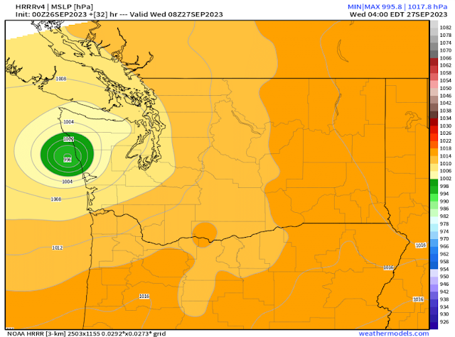
Now, let's take a look at the significant uncertainty regarding Wednesday's forecast. The uncertainty is based around the location of a compact area of low pressure making landfall on the coast. The most impactful rain and strong winds will be to the south of the low center. However, there is major disagreement on where the low center will make landfall, thus making a huge difference in where the biggest impacts are.

Let's start by looking at the European model's forecast, seen below.


The European model has the low center making landfall on the Northern Olympic Peninsula, which will bring impacts to most of Western Washington (since the low will move NE after landfall). 

Let's compare this to the HRRR high-resolution model, seen below.


The HRRR forecast is slightly different, showing the low making landfall near Moclips and Seabrook on the Central WA Coast. This would shift the impacts a bit further south, likely still including most of the metro area.

However, the discrepancy is clearly seen when we look at the NAM high-resolution forecast, seen below.


The NAM shows the low making landfall on the Long Beach Peninsula, sparing the metro area and most of Western Washington from the impacts, and putting SW Washington, the Portland area, and the Northern Oregon Coast in the crosshairs.

The UW WRF high-resolution forecast shows even more discrepancy from the others, seen below.


This forecast has the low making landfall near Tillamook, isolating the impacts to the Central Oregon Coast and the Willamette Valley from Salem southward.

There is nearly a 180 mile difference between the European and UW WRF forecasts, showing substantial uncertainty regarding what will happen on Wednesday. Stay tuned to Tuesday night's blog for a better picture of the forecast & impacts.

Sunday, September 24, 2023

First Storm of the Season: Bomb Cyclone Offshore Bringing Heavy Rain, Gusty Winds, and Large Waves

FastCast--Sunday, Sep. 24 to Tuesday, Sep. 26:

The first storm of the season is very close to impacting the Pacific Northwest. The main storm, a large and deep "bomb cyclone" (which means the storm's low pressure rapidly decreased 24 millibars in a 24 hour period) will remain offshore, but will push an atmospheric river into the Northwest, combined with gusty winds and large waves on the coast. For the lowlands, expect 1-2" of rain through Tuesday night, most falling from Sunday afternoon to midday Monday, followed by more rain from a secondary storm on Tuesday. Areas from Sequim northward to Bellingham will likely have less rain due to the Olympic rainshadow (0.25-0.75" possible). Some areas in the foothills may get up to 2.5". Winds will be gusty at times in the lowlands on Monday, mainly SE winds gusting 20-30 mph, except stronger (35-45 mph) for the Northwest Interior and San Juan Islands. More wind is possible on Tuesday, but details still remain uncertain. In the lowlands, expect our chilliest weather in months, with highs in the low to mid 60s and lows in the mid 40s to low 50s. Also, be prepared for a chance of isolated thunderstorms & heavy showers on Monday and Tuesday. Continue reading below for more storm information!

---------------------------------------------------------------

Continue reading the full blog below!

The first storm of the season is ahead for the Pacific Northwest, and it will be a multi-faceted system with a few different impacts. 

Let's start with the storm itself. The main storm will remain offshore, but will be a massive system. Below is the European model forecast for the storm.


This will be a very deep storm, deepening explosively (categorizing it as a "bomb cyclone") to 959 millibars, extremely low for September!

While the storm will remain offshore, its impacts will reach quite far. The most noticeable impact will be an atmospheric river aimed at the Pacific Northwest. Below is the UW WRF forecast for water vapor transport, showing the atmospheric river at 4 AM Monday.


Notice the current of highly concentrated moisture aimed directly up the Pacific Northwest coastline. This will bring the biggest rain event since late spring.

Let's take a look at expected rain totals, comparing the European Ensemble (EPS) versus the American GFS. We'll start with totals through Monday night, seen below on the EPS.


Through Monday night, the EPS shows 0.5-0.8" for the lowlands, with more (0.8-1.5") west of Puget Sound. The coast will get 1.2-2", the mountains will get 0.75-3" (most in the Olympics), and the rain shadow will drop San Juan Islands totals to 0.3-0.5" per this forecast.

Let's compare this to the GFS forecast, also through Monday night.


The GFS shows more rain through Monday night than the EPS. This forecast shows 0.8-1.4" in the lowlands, up to 3" on the Kitsap Peninsula (likely somewhat overdone), and 1.2-2" on the coast. The mountains get 0.75-2", with up to 4-5" possible in the Olympics. Another note here is that the rainshadow covers from Victoria BC to Whidbey Island, and is stronger, with 0.05-0.25" in the center of the rainshadow.

Now, let's see what these forecasts show for total rain through Tuesday night, seen below starting with the EPS.


The EPS shows lowland totals increasing to 1-1.5" (an additional 0.4-0.5"), with coastal totals up to 2-3" and mountain totals up to 1-2.5", except up to 5: in the Olympics. Overall, this forecast shows an additional 0.4-0.75" for the region on Tuesday.

Let's compare that with the GFS forecast, also going through Tuesday night.


The GFS forecast shows the lowlands getting 1.1-2.9" of rain through Tuesday (an additional 0.3-1"), with the coast getting 1.8-2.5", and the mountains getting 1-3", except up to 7" in the Olympics.

Overall, expect rain from Sunday afternoon through Monday evening, then again on Tuesday.

The next aspect of this storm that we'll cover is the wind. Even though the bomb cyclone is far offshore, it is very large and will spread winds into the Pacific Northwest. These winds will predominantly be southeasterly. 

Below is the European model forecast for peak wind gusts from Monday afternoon to early evening.


This forecast shows winds on the coast gusting 40-45 mph, with gusts of 25-45 mph for the Northwest Interior, especially the San Juans. The remainder of the area will have gusts of 20-30 mph. 

Let's compare this to the high-resolution NAM forecast, showing wind gusts at 4 AM Monday (earlier peak than the European).


The NAM forecast shows winds peaking earlier and stronger. This forecast shows SE winds gusting 40-50 mph (possibly up to 55 mph) at the coast, 30-40 mph from Everett northward, and 45-50 mph in the San Juans and Northern Whidbey Island. The lowlands will likely peak at 25-35 mph in this forecast.

Remember, despite relatively average wind speeds for a PNW storm, power outages can occur much more easily at this time of year due to trees being fully loaded with leaves.

The final impact of this storm will be large waves. Since the bomb cyclone is very large and deep, it will churn up the ocean for a long time. This will cause large swells and large breakers along the coast, all the way from  Northern British Columbia to Northern California. Below is the European model forecast for wave heights at 7 PM Monday.


Waves of 15-25 feet will hit the coast from Coos Bay northward to Haida Gwaii in the Queen Charlotte Sound of Northern BC. From San Francisco to Coos Bay, waves will be elevated, peaking around 8-15 feet. These waves are unusual for this time of year, so be prepared for changing beach conditions, hazardous breaking waves, and waves running far up the beach. Minor coastal erosion could be possible around high tide near the strongest waves.

This is quite a storm moving into the Northwest to kick off storm season, and another (smaller) storm is ahead on Tuesday, which could bring more impacts. Stay tuned & stay safe!

Thursday, September 21, 2023

Major Pattern Change Ahead for the Pacific Northwest

FastCast--Friday, Sep. 22 to Monday, Sep. 25:

A major weather pattern change is ahead for the Pacific Northwest, beginning this weekend. First, we will have our final "nice" day for quite awhile on Friday, with sunny skies and lowland highs in the mid to upper 70s and crisp morning lows in the mid 40s to low 50s. Conditions will change over the weekend, with clouds arriving and much cooler temperatures expected. On Saturday, expect cloudy conditions and highs in the mid to upper 60s. Rain is expected to arrive in the afternoon as a weak system moves through, with 0.1-0.3" possible in the lowlands, with isolated higher amounts possible. A much more robust system, likely our first storm of the season, will move through from Sunday evening through Monday. Models still have some disagreement on the strength of this system and how much rain it will bring, but a good consensus for the lowlands is an additional 0.4-1" by Monday night, the largest rain amounts we've seen since early May. Highs from Saturday to Monday will likely be in the mid to upper 60s, with lows in the upper 40s to mid 50s. More systems (and more rain) are likely through next week, but details remain uncertain, so stay tuned!

--------------------------------------------------------------

Continue reading the full blog below!

A major pattern change is likely for the Pacific Northwest this weekend, with wet and stormy conditions expected into next week (and beyond). Let's take a look at the forecast!

Below is the European Ensemble (EPS) upper-air forecast for late Sunday night.


Notice the large trough off the Pacific Northwest. Troughing will be dominant through the next 7+ days, bringing storms into the region. 

Let's compare this to the GFS Ensemble (GEFS) for the exact same time (late Sunday night).


The GEFS has a nearly identical forecast, showing that there is very good model agreement in a pattern change.

But, before we get there...the last warm & sunny day for quite awhile is ahead on Friday. Below is the European model forecast for Friday's highs.


Expect lowland highs in the mid to upper 70s, summer's last stand (ironically on the first day of astronomical fall). The coast will reach the mid 60s to low 70s (except in the mid to upper 50s at the beaches), the Willamette Valley will reach the upper 70s, and Eastern Washington will reach the upper 60s to mid 70s.

Clouds will increase overnight into Saturday, with some rain from a weak system arriving Saturday afternoon. Then, a more significant system will begin impacting the area Sunday evening, continuing through Monday. We'll take a look at the rain forecast through Sunday night on the EPS and GFS forecasts.

First, the European EPS forecast through 11 PM Sunday.


The European EPS forecast shows 0.2-0.4" in the lowlands by Sunday night, with 0.4-0.6" on the coast and 0.5-0.75" in the mountains. Also, notice the swath of rain in Eastern Oregon and SE Washington, which is from the previous system (Wednesday-Thursday of this week).

We'll compare this to the GFS forecast for total rain by 8 PM Sunday (3 hours earlier than the EPS).


Notice the GFS shows significantly more precipitation by Sunday night, with 0.4-0.6" in the lowlands and 0.4-1.2" on the coast, plus 0.5-1.4" in the mountains. This forecast also shows the typical rainshadow northeast of the Olympics. 

This shows that there is still disagreement in the timing of the second, more powerful system (Sunday night to Monday). The European EPS shows the heaviest rain not moving in until early Monday morning, while the GFS shows it moving in Sunday evening. Stay tuned for more updates on this.

Now, let's take a look at the extended forecast and what is likely ahead with this pattern change. First, we'll look at Seattle's rain chances, then temperatures in Seattle and Spokane.

Below is the European EPS forecast with all 50 ensemble members showing total rain through the next 15 days.


The ensemble mean (bar at bottom) and all the members agree with rain onset over the weekend, getting heavier midweek. The ensemble mean for the next 2 weeks is around 2.5". These totals will be higher in the mountains and on the coast, and likely far less in Eastern Washington.

Let's compare this to the GEFS forecast, which only has 30 ensemble members, showing total rain through the next 10 days (less than the previous forecast).


The GEFS shows around 2" of rain through the next 10 days (around October 1), which is nearly the same as the European EPS forecast. Both forecasts show moderate confidence in light rain on Saturday, with much higher confidence in the late Sunday-Monday system.

Now, let's take a look at temperatures in Seattle and Spokane. First, the Seattle forecast from the European EPS model.


This forecast shows highs in the upper 70s on Friday, followed by a clear decrease to the 60s for the remainder of the forecast. Notice a warmer day on Monday (highs in the upper 60s), with warmer lows from Monday to Wednesday. This is likely due to the subtropical component of the incoming systems, since there is an atmospheric river potential.

Next, let's look at the same forecast for Spokane, seen below.


This forecast shows Spokane's highest temperature on Monday, then a sharp decline over the remainder of next week, reflected both in highs and lows.

To round out the blog, we'll take a look at the NWS Climate Prediction Center 6-10 day forecasts for September 27 to October 1, showing what to expect late next week.

First, the temperature outlook, seen below.


This forecast shows a 50-70% probability of below average temperatures for the Northwest.

Next, we'll look at the precipitation outlook.


This forecast shows a 50-70% probability of above average precipitation for the Northwest.

So, the bottom line is that a significant pattern change is likely for the Northwest, with much more rain and cooler temperatures expected. Stay tuned over the coming days as details get clearer and forecasts get more refined!

Tuesday, September 19, 2023

Mix of Rain & Sun, Then Major Changes Likely

FastCast—Wednesday, Sep. 20 to Sunday, Sep. 24:

A system is moving through Western Washington as we go from Tuesday night to Wednesday morning. Areas from SeaTac northward in the lowlands will receive 0.3-0.5” of rain, with up to 1” in the Cascades. Areas from SeaTac south and on the coast will get 0.05-0.2” of rain. Highs on Wednesday will reach the low to mid 60s in the lowlands. This system will also bring the first dusting of snow to the highest peaks, with the snow level dropping to around 6,000 feet briefly on Wednesday morning. Conditions will clear almost completely on Thursday, with lowland highs reaching the upper 60s to low 70s, and chilly morning lows in the mid 40s. Friday’s highs will increase more, reaching the mid to upper 70s, with lows in the mid to upper 40s. However, Friday looks to be the last stand for warmer high temperatures. Clouds will move in on Saturday and Sunday, with highs dropping to the upper 60s to low 70s and a chance of showers on Saturday night and then again on Sunday night as a significant weather change (with far more rain) moves in. Stay tuned over the next few days for more information about the upcoming weather change.

————————————————————

Continue reading the full blog below!

A system is moving through as I write this blog, with showers across Western Washington (and soon in Eastern Washington). Let’s take a look at the upcoming forecast!

First, the precipitation forecast from the European Ensemble (EPS) through late Friday.


This forecast shows that most rain will fall from Tacoma northward and east of Puget Sound, with 0.2-0.4” expected. From Everett northward, expect 0.2-0.5” of rain, with up to 0.8” in the Cascades. The coast will get 0.1-0.2”. Eastern Washington will get 0.2-0.4”, except 0.4-0.9” from Spokane south and from the Tri-Cities east.

Let’s compare this to the GFS forecast, also showing precipitation through Friday night.


The GFS shows far less precipitation overall, but also shows most for the Cascades and parts of Eastern Washington.

Going back to the European Ensemble (EPS), let’s zoom in on Western Washington.


Notice that the highest precipitation amounts are from Sea-Tac Airport north toward Everett, and east into the Cascades. Those areas have a chance for Convergence Zone banding, which will bring prolonged precipitation on Wednesday. Up to 0.75” is expected for areas such as Renton, Bellevue, and the Cascade foothills from Black Diamond northward. Areas from Everett northward will also get 0.3-0.8”. Areas not mentioned will likely get a trace to 0.2”.

This system will also bring the snow level down to 6,000 feet on Wednesday morning, and some higher peaks will get their first dusting of snow! Below is the first European Ensemble (EPS) snow map of the season!


Notice some higher peaks could get a trace to 0.5” of snow…a sign that storm season is getting closer. If you’re hiking in the backcountry, be prepared for significantly cooler temperatures than recent days.

Besides rain, you’ll notice significantly cooler temperatures on Wednesday, as seen in the European model forecast below.


On Wednesday, expect lowland highs in the mid 60s, coastal highs in the upper 50s to mid 60s, Willamette Valley highs in the upper 60s to low 70s, Eastern Washington highs in the upper 50s to upper 60s. 

Moving on to Thursday, expect temperatures to increase in the lowlands with clear skies. The European model forecast is below.


Expect lowland highs on Thursday in the upper 60s to low 70s, coastal highs in the upper 50s to upper 60s (up to the low 70s inland), Willamette Valley highs in the mid to upper 70s, and Eastern Washington’s highs in the mid 60s to low 70s.

Temperatures will increase further on Friday, before a cooldown for the weekend and beyond. Friday’s highs from the European model are below.


Expect lowland and Willamette Valley highs to reach the mid to upper 70s on Friday. The coast will reach the upper 50s to mid 60s, and Eastern Washington will reach the low 60s to mid 70s, coolest near the Idaho border south of Spokane due to lingering showers.

Finally, what you’ve been waiting to see…the “major changes” mentioned in the blog title! While this forecast below is not certain and will surely change, it represents the likely trend for the rest of September. Below is the EPS forecast showing ensemble mean precipitation through September 30th.


Wow!! This forecast shows 2-3 inches of rain for the lowlands, with even more for the coast and mountains! This is more rain than Western Washington has received in the past 4 months, and would certainly put an end to wildfire season.

Stay tuned as we get closer to a major weather change!

Short Spring Heat Wave for the Pacific Northwest

  FastCast--Thursday, May 9 to Tuesday, May 14: A spring "heat wave" is ahead for the Northwest, with the warmest temperatures see...