FastCast--Tuesday, Sep. 26 to Thursday, Sep. 28:
After an atmospheric river brought 0.5-1.5" of rain to most of Western Washington from Sunday to Monday, another couple storms are ahead. The next system takes aim on Tuesday, bringing more heavy rain (0.25-0.5" for the lowlands) and winds gusting 25-35 mph at times. There is also a chance of isolated thunderstorms, so if you are under a heavy shower, be prepared for possible thunder & lightning. A more complicated system arrives early Wednesday morning. The system, a compact area of low pressure, will pack strong winds and heavy rain, but will be far more impactful on its south side. However, there is significant disagreement in the forecast models about where this storm will make landfall on the coast. Forecasts range from the Northern Olympic Peninsula to the Northern Oregon Coast, giving a huge range of potential impacts. Should this storm move closer to the lowlands, it will likely bring another 0.5-1.5" of rain and potentially stronger winds. Stay tuned to Tuesday night's blog for more details. Another system will likely move through on Thursday, bringing another round of rain. Through Thursday, expect highs in the upper 50s to low 60s, with lows in the mid 40s to low 50s.
----------------------------------------------------------
Continue reading the full blog below!
As the atmospheric river and associated cold front & heavy showers move out of Western Washington, more storms are ready to take aim at our region. Let's take a look at the forecast!
We'll start with the European Ensemble forecast (EPS) showing total rain through Tuesday night.
Note...this forecast does include rain that fell on Monday. The estimated new rainfall on Tuesday in this forecast is 0.5-1", which is on the higher end of potential solutions. The coast will get a similar amount of new rainfall. However, Eastern Washington will likely pick up 0.1-0.5" of rain on Tuesday, their first widespread rain of the season.
Let's compare this to the GFS forecast, also showing total rain through Tuesday night.
The GFS shows 0.5-0.8" of rain on Tuesday from Olympia to Everett, with other areas in the lowlands getting 0.1-0.4". The coast will pick up 0.4-0.6" in this forecast, with Eastern Washington (mainly the eastern third) getting 0.2-0.5".
Yet another system (a much more complex storm with potential for impacts) will move onshore early Wednesday morning, bringing another round of rain and potentially wind. Below is the EPS forecast showing total rain through Wednesday night.
This shows the lowlands getting an additional 0.5-1.5" of rain on Wednesday, an additional 1-1.5" on the coast, and 0.2-0.3" for Eastern Washington. By Wednesday night, the Cascades will have a total of 0.5-2.5", and the Olympics will have 3-5".
That is an ambitious forecast that is likely on the higher end, but let's compare it to the GFS forecast, also showing rain through Wednesday night.
The GFS shows much less rain in the lowlands, with only an additional 0.1-0.3" possible on Wednesday. The coast will get more (0.4-0.6") and Eastern Washington will get another 0.1-0.5", most from Walla Walla to Spokane. This is a much different forecast than the EPS showed, which underscores the uncertainty in Wednesday's forecast.
This rain will likely cause areas of ponding and standing water, with urban flooding possible due to leaves clogging storm drains. Be cautious when driving in these conditions!
Now, let's take a look at the significant uncertainty regarding Wednesday's forecast. The uncertainty is based around the location of a compact area of low pressure making landfall on the coast. The most impactful rain and strong winds will be to the south of the low center. However, there is major disagreement on where the low center will make landfall, thus making a huge difference in where the biggest impacts are.
Let's start by looking at the European model's forecast, seen below.
The European model has the low center making landfall on the Northern Olympic Peninsula, which will bring impacts to most of Western Washington (since the low will move NE after landfall).
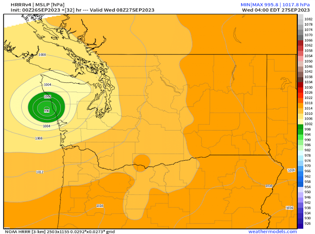
Let's compare this to the HRRR high-resolution model, seen below.
The HRRR forecast is slightly different, showing the low making landfall near Moclips and Seabrook on the Central WA Coast. This would shift the impacts a bit further south, likely still including most of the metro area.
However, the discrepancy is clearly seen when we look at the NAM high-resolution forecast, seen below.
The NAM shows the low making landfall on the Long Beach Peninsula, sparing the metro area and most of Western Washington from the impacts, and putting SW Washington, the Portland area, and the Northern Oregon Coast in the crosshairs.
The UW WRF high-resolution forecast shows even more discrepancy from the others, seen below.
This forecast has the low making landfall near Tillamook, isolating the impacts to the Central Oregon Coast and the Willamette Valley from Salem southward.
There is nearly a 180 mile difference between the European and UW WRF forecasts, showing substantial uncertainty regarding what will happen on Wednesday. Stay tuned to Tuesday night's blog for a better picture of the forecast & impacts.


Sounds like I will need to turn my furnace on. Thank you for all your good reports.
ReplyDelete