Thursday, November 30, 2023

Active Weather Returns: Major Snow, Strong Winds, and Heavy Rain Ahead

FastCast--Friday, Dec. 1 to Sunday, Dec. 3:

A major change in the weather is ahead for the Pacific Northwest, with a very active start to December in the works. The first storm will impact the region from Friday to midday Saturday, bringing significant mountain snow, strong winds, and heavy rain. In the lowlands, expect 0.75-1.4" of rain through Saturday evening, with the potential for less in a rain shadow from Seattle to the San Juan Islands. Snow levels will remain around 2,000-3,000 feet, bringing significant snow amounts of 24-36" to the passes. Travel impacts are expected, especially during the heaviest snow (likely on Friday and into early Saturday). Winds will be breezy on Friday morning (likely gusting 25-35 mph), but stronger winds are expected from late Friday night to early Saturday morning. Forecasts currently show gusts of 40-45 mph during this timeframe. The next system, which will be on the warmer side, arrives on Sunday, bringing another 0.5-1" of rain for the lowlands, plus more strong winds likely gusting 35-45 mph. However, snow levels will rise to near 6,000 feet on Sunday, bringing rain to the passes. This system will increase temperatures in Western Washington to the low to mid 50s. A much more significant atmospheric river is expected early next week, so stay tuned for more updates.

---------------------------------------------------------------

Continue reading the full blog below!

Very active weather is ahead for the Pacific Northwest, as we exit a persistent stagnant and cold pattern. Let's take a look at the forecast.

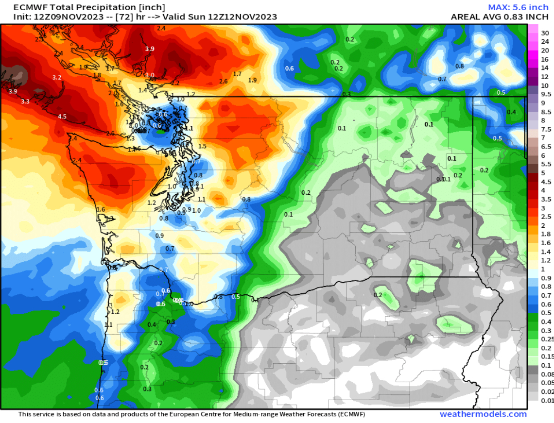
First, total rain through Saturday evening, seen below on the European model.


This forecast shows 0.75-1.3" for the lowlands through Saturday evening, with a rain shadow noticeable from Seattle north to the San Juans. The coast and Willamette Valley will receive 1.4-2.5" of rain through Saturday.

Let's compare this to the high-resolution NAM forecast, also through Saturday evening.


The NAM forecast shows less rain for the lowlands, with 0.6-1" possible, and a more significant rain shadow from Seattle to the San Juans, with only 0.1-0.4" in the rain shadow. This forecast also gives the coast 1-2" and the Willamette Valley 0.5-1".

Now, let's take a look at the snow forecast for the mountains and Eastern Washington. Below is the European model showing total snow through Saturday night.


This forecast shows the passes receiving 18-36" of snow through Saturday night, bringing significant travel impacts and potential pass closures. Additionally, Eastern Washington gets a region-wide snow event. Cities including Ellensburg, Wenatchee, Moses Lake, Spokane, and Pullman get 2-5", with the Tri-Cities, Yakima, and Walla Walla getting 1-3". 

Let's compare this to the NAM high-resolution snow forecast, also through Saturday evening.


This forecast also shows 18-36" of snow for the passes, but paints a different picture for Eastern Washington. According to this forecast, areas closer to the Cascades receive 1-3", with areas further east getting much more. This shows Spokane getting 4-6" and Pullman getting 6-10". This forecast is somewhat less likely, but in the realm of possibility.

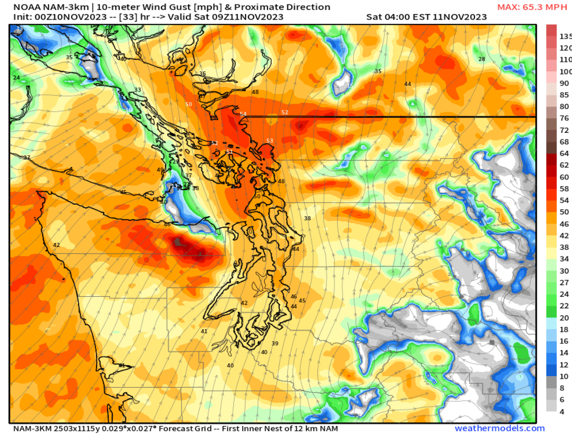
Finally, let's take a look at the wind forecast for early Saturday morning, starting with the European model. 


Winds will surge as a cold front and associated heavy rain move through the region early Saturday. This forecast (displayed above in knots instead of mph) shows lowland winds gusting 30-45 mph, strongest near the water, with winds reaching 40-45 mph from Whidbey Island northward. The coast would gust 40-50 mph with this forecast.

Let's compare this to the high-resolution HRRR forecast, which shows substantially stronger winds for the whole region.


This forecast shows winds (in mph) gusting 40-50 mph in the lowlands, with localized gusts over 50 mph. The coast would reach 45-60 mph in this forecast, strongest from Ocean Shores southward. This is definitely a possible wind forecast, so stay tuned for more information.

With a lot of active weather and potential forecast changes ahead, I will do another post Friday night, with the latest updates for winds, mountain snow, and rain. Stay tuned!!

Tuesday, November 28, 2023

Major Changes Ahead: Heavy Mountain Snow, Return of Rain

FastCast—Wednesday, Nov. 29 to Saturday, Dec. 2:

One more cold and stagnant day with morning lows in the upper 20s and areas of dense fog and some areas of freezing fog lasting into the afternoon is expected on Wednesday. Highs will only reach the upper 30s to low 40s. However, major changes are afoot. On Thursday, morning lows will reach the low 30s, but fog will lift, temperatures will increase to the low to mid 40s, and rain will arrive. Our stagnant air will clear out, and the lowlands will receive 0.25-0.5” of rain. There will be a brief break in the rain late Thursday, before rain continues on Friday, with another 0.5-1.3” for the lowlands as rain continues through Saturday evening. This storm will bring the first major mountain snow of the season, with the passes likely to receive 18-30”, mainly from Friday to late Saturday. For Friday and Saturday, expect lowland highs in the mid to upper 40s, with lows in the low 40s. Friday will also be breezy across the area, with winds gusting 25-35 mph, strongest near the water.

——————————————————————

Continue reading the full blog below!

Major weather changes are ahead for the Northwest, as the persistent high pressure ridge that has brought an inversion (trapping fog and cold air near the surface) will break up on Thursday. 

However, on Wednesday morning, freezing fog is possible across the lowlands, with morning lows in the upper 20s to low 30s. Fog may persist well into the afternoon in the South Sound as has happened on Monday & Tuesday. Degraded air quality will persist into early Thursday, until onshore winds erode the stagnant air that is in place.

Rain will begin midday Thursday, with a break overnight and then more persistent rain from Friday to Saturday. Mountain snow is most likely from early Friday to late Saturday. 

Let’s start by taking a look at the European model forecast for rain through Saturday night.


Through Saturday night, the European model shows 1-1.5” for the lowlands, with 0.5-0.8” in the rain shadow from Everett to Victoria BC. Areas from Olympia southward to the Willamette Valley will likely receive 1.5-2” of rain, with 1.5-2.5” on the coast. For the mountains below 2,500 feet, expect up to 2” of rain.

Let’s compare the European model rain forecast to the GFS (American) model, seen below also showing rain through Saturday night.


The GFS shows less rain overall, with 0.7-1.3” for the lowlands, a slightly larger rain shadow, extending from Seattle to Bellingham (0.5-0.8” in this area), and totals from Olympia south and on the coast around 1-1.5”. 

Now, let’s shift gears to the first major mountain snow event of the season. Below is the European model forecast for snow through Saturday night.


The European model shows an impressive 18-30” of snow for the passes, mainly from Friday to Saturday. Significant impacts are possible, so stay tuned. Additionally, snow is possible across Eastern Washington from Thursday night into early Saturday. The European model shows 2-4” north of I-90 (up to 6” near Ellensburg and Wenatchee), with 0.5-1.5” for the rest of Eastern WA except the Pullman area, where 3-5” are possible. 

Next, let’s take a look at the GFS forecast for snow, also through Saturday evening, seen below.


The GFS forecast also shows 18-30” for the passes, but has a different forecast for Eastern Washington. This model shows up to 6-8” of snow around Spokane, with 4-6” around the Palouse, but only 1-2” for the rest of Eastern Washington.

We’ll round out this blog by taking a look at the high-resolution UW WRF forecast for rain (Western WA only) through Saturday evening.


The UW forecast shows 0.75-1.5” from Tacoma southward, with 0.5-0.75” from Tacoma northward. The coast gets 1.25-2” in this forecast, with areas from Olympia south getting 1.5-1.75”.

Finally, the UW forecast for snow across Washington through Saturday evening.


The UW forecast also shows 18-30” for the passes, with 4-6” for the Palouse and Spokane area, and 0.5-2.5” for the rest of Eastern WA, except more close to the Cascades. 

The upcoming storms are likely the first of multiple potent storms, with much more active weather possible from the weekend into next week, so stay tuned to the blog for more information!

Saturday, November 25, 2023

Cold & Dry Weather Through End of November

FastCast—Sunday, Nov. 26 to Thursday, Nov. 30:

A persistent cold and dry pattern will continue for the Pacific Northwest through the end of November. For the lowlands, expect morning fog (sometimes lingering into the afternoon), with afternoon sun. There is a possibility that if an inversion develops (where cooler air is trapped near the surface…aka trapped in the low elevations of both sides of the Cascades), fog and low clouds will remain widespread through the day, with temperatures staying in the upper 30s to low 40s most of the day. Temperature-wise, in the lowlands, expect highs in the low to mid 40s, with cold morning lows in the mid 20s to low 30s, coldest away from the shoreline. Be aware for potential freezing fog, which can bring significant driving hazards around the region. A significant pattern change to much stormier weather is possible to start December, so stay tuned.

With little wind and multiple cold & dry days ahead, air quality will likely degrade. Check air quality at the link below and consider the impact of burning before doing so.

Washington State Air Quality Map—PurpleAir (zoom in to find your location)

——————————————————

Continue reading the full blog below!

A persistent cold, calm, and generally sunny pattern will prevail for much of the next week across Washington state. Let’s take a look at the forecast!

We’ll start with the forecast for low temperatures on Sunday morning, seen below from the European model.


In the lowlands, expect lows in the mid 20s to low 30s, with the coast and Willamette Valley reaching the upper 20s to low 30s. Eastern Washington will drop to the upper teens to mid 20s.

Next, the forecast for lows on Monday morning, seen below.


Monday will be similar, with morning lows in the lowlands reaching the mid 20s to low 30s. The coast will reach the low to mid 30s, and the Willamette Valley will reach the upper 20s to low 30s. Eastern Washington will remain in the upper teens to mid 20s.

Next, let’s take a look at the fog forecast for Monday morning, seen below from the European model.


Notice that parts of the lowlands have visibility of 0.1-0.5 miles, along with parts of Eastern Washington, including the Tri Cities and Walla Walla. A good amount of this fog could be freezing fog, which can create the same (and sometimes worse) hazards than black ice.

Next, the European model forecast for lows on Tuesday morning, seen below.


On Tuesday morning, expect lowland lows in the mid 20s to low 30s again, with the Willamette Valley dropping to similar levels, and the coast remaining in the low 30s. Eastern Washington will stay cold, with lows still in the low to mid 20s (isolated teens).

Here is the European model fog forecast for Tuesday morning.


Fog is somewhat widespread from around Thurston County all the way to Vancouver BC, with visibility down to 0.1-0.3 miles. Areas of fog are likely in the Willamette Valley and parts of Eastern Washington as well.

Although a pattern change is likely ahead to begin December, it’ll be quite cold before we can get to the stormier weather. Below is the European model forecast for highs on Wednesday.


Expect Wednesday’s highs to only reach the low 40s for the lowlands and mid to upper 30s in Eastern Washington. This will be due to an inversion trapping colder air near the surface. Notice that the mountains are warmer than the lower elevations.

Finally, take a look at the NWS Climate Prediction Center (CPC) precipitation outlook for December 1-5.


This is a good signal for a pattern change to wetter and stormier weather for the Northwest to begin December, with the CPC showing a 50-60% probability of above average precipitation for the Northwest. 

Stay warm out there (and be aware for cold-related hazards!).

Thursday, November 23, 2023

Cool and Dry Thanksgiving Day & Holiday Weekend

FastCast—Thursday, Nov. 23 to Monday, Nov. 27:

A cool, dry, and mostly sunny Thanksgiving and holiday weekend lies ahead for the Pacific Northwest. In the lowlands, expect morning clouds and afternoon sun on Thanksgiving, with highs in the mid 40s. Temperatures will drop by early Friday morning, with morning lows dropping to the mid 20s to low 30s in the lowlands for Friday, Saturday, Sunday, and Monday mornings. Afternoon highs will reach the mid 40s, under mostly sunny skies. Temperatures will be even colder in Eastern Washington, with highs in the mid 30s to low 40s and lows in the low 20s to low 30s. 

———————————————————

Continue reading the full blog below!

A cool, dry, and mostly sunny holiday weekend is ahead for the Pacific Northwest! Let’s take a look at the forecast, starting with highs on Thanksgiving, from the European model.


Expect Thanksgivng highs in Western Washington to reach the mid 40s, with the low to mid 40s likely in Eastern Washington.

Now for low temperatures. It’ll be quite chilly for the next few nights/mornings. Let’s take a look at the forecast, starting with lows on Friday morning (European model forecast).


In the lowlands, expect lows in the mid 20s to low 30s, coldest east of I-5. Eastern Washington will drop to the low 20s to low 30s, with the Willamette Valley and the coast reaching the low 30s.

Next, lows on Saturday morning, seen below.


On Saturday morning, expect lowland lows in the mid to upper 20s, with the coast dropping to the upper 20s to low 30s, and the Willamette Valley reaching the upper 20s to low 30s. Eastern Washington will be quite chilly, with lows in the upper teens to mid 20s.

Finally, the lows for Sunday morning, seen below.


Sunday morning will be quite similar to Saturday, with lowland and coastal lows in the upper 20s to low 30s, Willamette Valley lows in the upper 20s to mid 30s, and Eastern Washington’s lows in the low 20s to low 30s. 

We’ll round out this blog with the rain forecast through Sunday night, seen below, from the European model.


Expect virtually no rain for most of Washington state, with a few areas of isolated drizzle possible early Thursday for the southern tier of the state.

Have a Happy Thanksgiving, and enjoy the sun (and stay warm)!

Monday, November 20, 2023

Brief Rain, Then Cooler & Drier for Thanksgiving

FastCast—Tuesday, Nov. 21 to Friday, Nov. 24:

The next system is expected to move into the region late Tuesday, with rain lasting through early Wednesday. For the lowlands, expect 0.3-0.6” of rain through early Wednesday morning. Then, conditions will dry out and cool down, with a dry Thanksgiving expected. Temperatures will be a bit interesting. On Tuesday, expect lowland highs to reach the low to mid 50s due to southeasterly flow. Rain will move through from Tuesday evening through early Wednesday. On Wednesday, temperatures will reach the upper 40s, with clouds decreasing by evening. Thanksgiving will bring morning clouds and afternoon sun, with highs in the mid to upper 40s. Friday will likely be mostly sunny, with highs in the mid to upper 40s. Low temperatures will reach the mid 30s on Tuesday morning, the low to mid 40s on Wednesday and Thursday mornings, and down to the low to mid 30s on Friday morning.

———————————————————

Continue reading the full blog below!

The next system is ahead for Western Washington, bringing one final round of rain before Thanksgiving. Let’s take a look at the forecast.

Below is the rain forecast from the European model.


The European model shows 0.3-0.6” for the lowlands, 0.6-0.9” for the coast, and 0-0.1” for Eastern Washington. Most rain will wrap up by early Wednesday morning.

Let’s compare this to the NAM high-resolution forecast, showing rain through Wednesday.


The NAM high-resolution model shows 0.3-0.5” for the lowlands, with 0.5-0.9” on the coast, and scattered areas of a trace of rain for Eastern Washington.

Tuesday will be an anomalously warm day for the lowlands. Below is the European model forecast, zoomed in to Western Washington.


Expect lowland highs to reach the mid 50s, with some areas (mainly near the foothills) reaching the upper 50s, due to downslope flow. 

Let’s take a look at the extended forecasts from the European Ensemble (EPS) forecasts, from Seattle and Spokane. 

First, the EPS Seattle forecast.


Aside from Tuesday, notice that temperatures will remain on the cooler side, with highs in the mid 40s through the end of November. Lows will cool for Friday to Monday, dropping to the upper 20s to low 30s around the lowlands.

Let’s compare this to Spokane’s forecast from the European EPS model.


In Spokane, temperatures will remain in the upper 30s to low 40s, with overnight lows on the cold side, especially from Thanksgiving to early next week. Some mornings may get as cold as the low 20s!

Enjoy the relatively calm and normal weather ahead!

Friday, November 17, 2023

Next Storm Ahead: Wind, Rain, and Mountain Snow Likely

FastCast—Saturday, Nov. 18 to Thursday, Nov. 23:

After a calm and sunny few days, the next storm is ahead. Rain and wind will increase late Saturday evening and into the night, with winds peaking Sunday morning. The best chance of rain is from Saturday afternoon through Sunday morning. Wind-wise, expect gusts of 45-55 mph (locally up to 60 mph) on the coast, 40-55 mph for Whidbey Island due to a westerly wind surge, and 35-45 mph in the lowlands, strongest near the water. Some tree damage and power outages are possible. Across the lowlands, expect 0.3-0.5” of rain, with isolated areas getting up to 0.75”. The passes will get up to 3-5” of snow, with a trace to 3” at Snoqualmie Pass. Through Thanksgiving Day, expect highs in the upper 40s to low 50s, with lows in the mid 30s to low 40s. There is a chance of showers on Tuesday and Wednesday, but otherwise, it will be partly sunny and relatively calm.

—————————————————————

Continue reading the full blog below!

The next storm will bring wind, rain, and mountain snow to the Pacific Northwest from Saturday afternoon through Sunday morning. Let’s start by taking a look at the wind forecast, starting with the HRRR model. This forecast is the most aggressive for wind speeds in this storm.


This forecast shows winds gusting 35-40 mph in the lowlands (isolated stronger gusts near the water). Additionally, notice a strong westerly wind surge impacting the entire Strait region, Whidbey Island, the Admiralty Inlet area, and western Snohomish and Skagit Counties, with gusts of 45-55 mph. This storm will also bring gusts of 45-55 mph to the coast.

Next, let’s take a look at the NAM high-resolution forecast, showing wind gusts first at 4 AM Sunday.


At 4 AM Sunday, this forecast shows gusts of 35-40 mph for most of Western Washington, except 45-50 mph on the coast.

Next is the NAM forecast for wind gusts at 9 AM Sunday.


Notice the NAM also shows a westerly wind surge, though noticeably less strong than the HRRR. This forecast shows winds gusting 40-45 mph, mainly confined to Whidbey Island and areas along the Strait.

Next, let’s take a look at the rain forecast, seen below on the European model.


The European model shows 0.2-0.5” of rain in the lowlands with this system, with isolated areas getting 0.6-0.75”. The coast will get 0.6-1.1”, with 0.75-1.5” in the mountains. 

Finally, let’s take a look at the mountain snow forecast, also from the European model.


This forecast shows 3-6” at the passes, with higher amounts (up to 8”) at Stevens and White Passes, and up to 12-18” at Paradise and Mount Baker. Snoqualmie Pass will likely get 1-3” of snow out of this storm due to the snow level being close to 3,000 feet.

After this storm, benign weather is expected all the way through Thanksgiving. 

Monday, November 13, 2023

Cool, Dry, and Mostly Sunny Week Ahead

FastCast—Tuesday, Nov. 14 to Saturday, Nov. 18:

A cool, dry, and mostly sunny week is ahead for the Northwest! With the exception of a weak system on Wednesday, it will be mostly sunny and dry every day through Friday. The next system will arrive late Saturday, likely bringing a round of rain and breezy conditions. Until then, expect mostly sunny skies (except mostly cloudy on Wednesday), with highs only reaching the upper 40s to low 50s. Morning lows will be noticeably colder than previous nights, dropping to the low to mid 30s each morning this week. The main impact will be morning fog, locally dense, and the potential for black ice. Remember to be aware when driving in foggy conditions and always be ready for black ice. The system on Wednesday will bring clouds, but little chance of rain. Light rain (if any) is possible in the lowlands, with a dusting of snow possible in the mountains above 2,000 feet.

(Peak wind gusts from weekend storm at bottom of blog)

———————————————————

Continue reading the full blog below!

A significant change in the weather…to a chilly and sunny pattern…is ahead. With the exception of mostly cloudy skies with scattered drizzle on Wednesday, mostly sunny conditions are likely through Friday. 

The biggest weather impact to watch for will be morning fog. Some areas of dense fog are possible, especially in the South Sound. Fog is most likely on Thursday and Friday, but is possible any day this week.

Low temperatures will be significantly colder than recent days, so let’s take a look at the forecast, starting with lows on Tuesday morning from the European model.


On Tuesday morning, expect lowland lows in the low to mid 30s, coldest east of I-5 and from Everett northward. The Willamette Valley will drop to the mid to upper 30s, while Eastern WA will cool to the upper 20s to low 30s, except the mid 30s for the southern tier. Mountain towns will drop to the 20s.

Wednesday morning’s lows will be warmer due to the influx of clouds from the weak system.


Notice that Wednesday morning’s lows rise to the mid 30s to low 40s for the lowlands and Eastern Washington, with some isolated spots dropping to around freezing. The Willamette Valley will remain in the low 40s.

However, morning lows plunge by Thursday morning, seen below.


Thursday morning will be significantly colder, with lowland lows in the upper 20s to low 30s, Eastern Washington lows in the mid 20s to low 30s, and Willamette Valley lows in the low to mid 30s. Mountain towns will drop to the low 20s.

Finally, a look at Friday morning’s lows, seen below on the European model.


On Friday morning, lows will again be in the upper 20s to low 30s for most of the lowlands, with all of Eastern Washington in the mid 20s to low 30s. The Willamette Valley will drop to the low to mid 30s again.

One notable difference with this week versus the rest of the month so far is the absence of rain. Below is the European model forecast for rain through Friday night.


Notice that almost all of Western Washington is dry, with only the northern and southern portions of Western WA getting up to 0.1” of rain. Eastern Washington, including the Tri Cities, Spokane, Pullman, and Walla Walla, will get 0.1-0.3” on Wednesday. The Willamette Valley will get 0.1-0.2” as well.

Enjoy the dry week and the mostly sunny conditions!

——————————————————

Peak Wind Gusts: November 10-11, 2023:

Whidbey Island Naval Air Station: 64 mph

Bellingham Int’l Airport: 64 mph

Camano Island: 58 mph

Hoquiam Airport: 55 mph

Cape Disappointment: 53 mph

Tacoma Narrows Airport: 52 mph

Everett Paine Field: 51 mph

Olympia Airport: 51 mph

Sea-Tac Airport: 41 mph

Shelton Airport: 40 mph


Friday, November 10, 2023

Western Washington Windstorm Update

No FastCast tonight...continue reading the full blog below for a windstorm update (and an updated look at rain and mountain snow forecasts). Heavy rain and strong winds are likely with frontal passage early Saturday morning. There is also a chance of thunderstorms in post-frontal showers on Saturday.

Across Western Washington, expect winds to peak from late Friday night to early Saturday morning.

Let's start with the high-resolution HRRR forecast, showing peak winds during this storm.


This forecast has consistently shown stronger winds than other forecasts, but has been accurate as of 10 PM. This forecast shows 50-60 mph gusts from Everett northward, including gusts near or just over 60 mph near Bellingham. Areas from Everett southward will gust 40-50 mph in this forecast. The coast will gust up to 45-55 mph in this scenario as well. If this forecast verifies as shown above, power outages and tree damage is likely.

Let's compare this to the NAM high-resolution forecast, seen below at 1 AM Saturday.


At 1 AM, the NAM forecast shows gusts of 45-55 mph from Seattle northward. From Seattle south, the NAM shows gusts reaching 40-45 mph around 1 AM, with gusts up to 50 mph on the coast.

Fast forward to 5 AM Saturday, seen below on the NAM forecast.


Around 5 AM, expect gusts in the lowlands to reach 45-50 mph, as frontal passage nears. As with the previous forecast, tree damage and power outages are possible with this storm. Localized gusts over 50 mph are possible in the lowlands.

Finally, let's take a look at the European model forecast for peak wind gusts, showing the entire state.


This forecast is in knots, so actual miles per hour speeds will be stronger. This forecast shows gusts in the lowlands reaching 40-45 mph, with 45-55 mph gusts from Everett northward, but mainly on the water and in western Whatcom County. Eastern Washington will gust 40-50 mph, strongest east of the Tri Cities and around the Spokane area. 

Let's take a look at the rain forecast from the European model, seen below. I've zoomed in these graphics to Western Washington, since Eastern WA won't have much rain (if any).


This forecast, through early Sunday morning, shows 0.7-1" of rain for most of the Puget Sound region, with a rain shadow from Seattle to Everett. The foothills could get 1-1.5" of rain, and parts of the coast will get up to 2", along with the mountains, where up to 3" is possible.

The GFS (American) forecast below shows agreement with the European model.


The GFS shows 0.7-1" for most of the region, with a rain shadow from Whidbey Island to Seattle. The coast and mountains will get 1-3" with this forecast.

Finally, the snow forecast for the mountains, seen below on the European model.


This forecast shows significant snow for higher elevations of the North Cascades, with up to 12-18" for the North Cascades Highway and Mount Baker, along with 6-12" at Paradise. The higher passes (Stevens & White) will get up to 6" of snow, while Snoqualmie Pass will get up to 2". Winter weather impacts will be relegated to areas over 4,000-4,500 feet.

Remember to be prepared for power outages and tree damage with the winds. Charge your devices and be careful out there! 


Thursday, November 9, 2023

Next Storm to Bring Strong Winds, Rain, and Mountain Snow

FastCast—Friday, Nov. 10 to Monday, Nov. 13:

After a relatively calm few days and a weakening storm that moved through on Thursday, a stronger storm will impact the Northwest from Friday afternoon through Saturday. The main impact will be strong winds, with a decent round of rain and mountain snow for the higher passes. Winds will likely gust 40-45 mph for most of the lowlands, 45-50 mph on the coast, and 50-55 mph from Everett northward, especially for Island, Whatcom, and San Juan Counties. Isolated gusts of 55-60 mph are possible for those areas. Region-wide, winds will peak from late Friday night through midmorning Saturday. Most of the lowlands will also receive 0.75-1.3” of rain through Sunday morning, most falling from Friday afternoon through Saturday morning. Higher elevations in the mountains, such as Paradise, Chinook Pass, and the North Cascades Highway will receive 6-12” of snow, with isolated higher amounts. Stevens and White Passes could see 0.5-2” of snow, as snow levels will hover around 4,000-4,500 feet. The next system will bring another round of rain and higher mountain snow from Sunday night to Monday. Through Monday, expect lowland highs in the low 50s, with lows in the mid 40s.

———————————————————————

Continue reading the full blog below!

An active couple days is ahead for Western Washington, as a storm approaches the region, with impacts being felt across the region. Let’s take a look at the forecast!

First, the wind forecast. We’ll start with the European model forecast for peak gusts through Saturday night.


This forecast (which is in knots) shows peak gusts from Everett southward reaching 40-45 mph, strongest early Saturday morning. For areas north of Everett, especially Island, San Juan, and western Whatcom Counties, peak gusts will likely reach 45-55 mph. Isolated gusts of 55-60 mph are possible. The coast will gust 45-50 mph. Both the coast and North Sound will have peak winds from late Friday night to early Saturday morning. Additionally, parts of Eastern Washington, mainly from Moses Lake to Spokane, will gust 40-50 mph on Saturday.

Let’s compare this to the NAM high-resolution wind forecast, first showing gusts at 1 AM Saturday.


The NAM shows strong gusts of 40-45 mph for most of the region very early Saturday morning. Whidbey Island, San Juan & Whatcom Counties, and the immediate coastline will gust up to 55 mph. 

Next is the NAM forecast for 6 AM Saturday.


The NAM forecast shows peak winds for the metro area being around sunrise on Saturday, with gusts of 40-45 mph (isolated gusts closer to 50 mph). 

Remember, it is still early in the season, and this weekend’s forecasted winds will likely cause tree damage and some power outages across the region. Trees still have lots of leaves, which will make them more susceptible to damage. Be prepared for winds and monitor the forecast accordingly!

Next, we will take a look at the rain forecast. First, the European model, showing total rain through Sunday morning (most will fall from Friday afternoon through Saturday morning, with some showers through Saturday).

This forecast shows 0.75-1.2” of rain for the lowlands, with a rain shadow over the San Juans. The coast will pick up 1-2.5” (most from Ocean Shores northward), and the mountains will get 1-3” (most in the Olympics & North Cascades). Eastern Washington will stay relatively dry with this system.

Below is the GFS (American) forecast, showing a similar scenario to the European.


The GFS forecast also shows 0.7-1.2” of rain for the lowlands, with 1-2.7” on the coast (most on the North Coast), and 1-4” in the mountains, most in the Olympics and North Cascades. The GFS and European strongly agree that Eastern Washington will remain almost completely dry with this storm.

Finally, we’ll end tonight’s blog with a look at the snow forecast through Sunday morning from the European model.


This forecast shows significant snow for higher elevations in the North Cascades and the higher peaks, with the North Cascades Highway, Mount Baker, and Paradise likely to get 6-12”. The passes will get much less due to snow levels staying around 4,000-4,500 feet during the storm. Expect 0.5-2” at most at the passes.

Stay tuned for a wind update on Friday night!

Short Spring Heat Wave for the Pacific Northwest

  FastCast--Thursday, May 9 to Tuesday, May 14: A spring "heat wave" is ahead for the Northwest, with the warmest temperatures see...