FastCast—Saturday, Nov. 18 to Thursday, Nov. 23:
After a calm and sunny few days, the next storm is ahead. Rain and wind will increase late Saturday evening and into the night, with winds peaking Sunday morning. The best chance of rain is from Saturday afternoon through Sunday morning. Wind-wise, expect gusts of 45-55 mph (locally up to 60 mph) on the coast, 40-55 mph for Whidbey Island due to a westerly wind surge, and 35-45 mph in the lowlands, strongest near the water. Some tree damage and power outages are possible. Across the lowlands, expect 0.3-0.5” of rain, with isolated areas getting up to 0.75”. The passes will get up to 3-5” of snow, with a trace to 3” at Snoqualmie Pass. Through Thanksgiving Day, expect highs in the upper 40s to low 50s, with lows in the mid 30s to low 40s. There is a chance of showers on Tuesday and Wednesday, but otherwise, it will be partly sunny and relatively calm.
—————————————————————
Continue reading the full blog below!
The next storm will bring wind, rain, and mountain snow to the Pacific Northwest from Saturday afternoon through Sunday morning. Let’s start by taking a look at the wind forecast, starting with the HRRR model. This forecast is the most aggressive for wind speeds in this storm.
This forecast shows winds gusting 35-40 mph in the lowlands (isolated stronger gusts near the water). Additionally, notice a strong westerly wind surge impacting the entire Strait region, Whidbey Island, the Admiralty Inlet area, and western Snohomish and Skagit Counties, with gusts of 45-55 mph. This storm will also bring gusts of 45-55 mph to the coast.
Next, let’s take a look at the NAM high-resolution forecast, showing wind gusts first at 4 AM Sunday.
At 4 AM Sunday, this forecast shows gusts of 35-40 mph for most of Western Washington, except 45-50 mph on the coast.
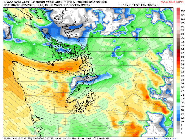
Next is the NAM forecast for wind gusts at 9 AM Sunday.
Notice the NAM also shows a westerly wind surge, though noticeably less strong than the HRRR. This forecast shows winds gusting 40-45 mph, mainly confined to Whidbey Island and areas along the Strait.
Next, let’s take a look at the rain forecast, seen below on the European model.
The European model shows 0.2-0.5” of rain in the lowlands with this system, with isolated areas getting 0.6-0.75”. The coast will get 0.6-1.1”, with 0.75-1.5” in the mountains.
Finally, let’s take a look at the mountain snow forecast, also from the European model.
This forecast shows 3-6” at the passes, with higher amounts (up to 8”) at Stevens and White Passes, and up to 12-18” at Paradise and Mount Baker. Snoqualmie Pass will likely get 1-3” of snow out of this storm due to the snow level being close to 3,000 feet.
After this storm, benign weather is expected all the way through Thanksgiving.


Sounds like we will have a calm day for Thanksgiving, happy to hear that forcast.
ReplyDelete