FastCast—Tuesday, Nov. 14 to Saturday, Nov. 18:
A cool, dry, and mostly sunny week is ahead for the Northwest! With the exception of a weak system on Wednesday, it will be mostly sunny and dry every day through Friday. The next system will arrive late Saturday, likely bringing a round of rain and breezy conditions. Until then, expect mostly sunny skies (except mostly cloudy on Wednesday), with highs only reaching the upper 40s to low 50s. Morning lows will be noticeably colder than previous nights, dropping to the low to mid 30s each morning this week. The main impact will be morning fog, locally dense, and the potential for black ice. Remember to be aware when driving in foggy conditions and always be ready for black ice. The system on Wednesday will bring clouds, but little chance of rain. Light rain (if any) is possible in the lowlands, with a dusting of snow possible in the mountains above 2,000 feet.
(Peak wind gusts from weekend storm at bottom of blog)
———————————————————
Continue reading the full blog below!
A significant change in the weather…to a chilly and sunny pattern…is ahead. With the exception of mostly cloudy skies with scattered drizzle on Wednesday, mostly sunny conditions are likely through Friday.
The biggest weather impact to watch for will be morning fog. Some areas of dense fog are possible, especially in the South Sound. Fog is most likely on Thursday and Friday, but is possible any day this week.
Low temperatures will be significantly colder than recent days, so let’s take a look at the forecast, starting with lows on Tuesday morning from the European model.
On Tuesday morning, expect lowland lows in the low to mid 30s, coldest east of I-5 and from Everett northward. The Willamette Valley will drop to the mid to upper 30s, while Eastern WA will cool to the upper 20s to low 30s, except the mid 30s for the southern tier. Mountain towns will drop to the 20s.
Wednesday morning’s lows will be warmer due to the influx of clouds from the weak system.
Notice that Wednesday morning’s lows rise to the mid 30s to low 40s for the lowlands and Eastern Washington, with some isolated spots dropping to around freezing. The Willamette Valley will remain in the low 40s.
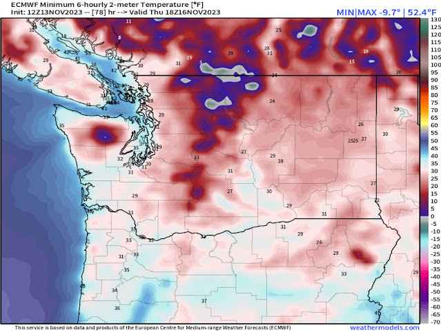
However, morning lows plunge by Thursday morning, seen below.
Thursday morning will be significantly colder, with lowland lows in the upper 20s to low 30s, Eastern Washington lows in the mid 20s to low 30s, and Willamette Valley lows in the low to mid 30s. Mountain towns will drop to the low 20s.
Finally, a look at Friday morning’s lows, seen below on the European model.
On Friday morning, lows will again be in the upper 20s to low 30s for most of the lowlands, with all of Eastern Washington in the mid 20s to low 30s. The Willamette Valley will drop to the low to mid 30s again.
One notable difference with this week versus the rest of the month so far is the absence of rain. Below is the European model forecast for rain through Friday night.
Notice that almost all of Western Washington is dry, with only the northern and southern portions of Western WA getting up to 0.1” of rain. Eastern Washington, including the Tri Cities, Spokane, Pullman, and Walla Walla, will get 0.1-0.3” on Wednesday. The Willamette Valley will get 0.1-0.2” as well.
Enjoy the dry week and the mostly sunny conditions!
——————————————————
Peak Wind Gusts: November 10-11, 2023:
Whidbey Island Naval Air Station: 64 mph
Bellingham Int’l Airport: 64 mph
Camano Island: 58 mph
Hoquiam Airport: 55 mph
Cape Disappointment: 53 mph
Tacoma Narrows Airport: 52 mph
Everett Paine Field: 51 mph
Olympia Airport: 51 mph
Sea-Tac Airport: 41 mph
Shelton Airport: 40 mph


No comments:
Post a Comment