8-26 Video Briefing: Next Storm System Hits Western Washington
Monday, August 26, 2024
Sunday, August 25, 2024
Brief Break, Next Storm Ahead
Video briefing for August 25th: Brief Break Ahead, Then Next Storm Arrives
Saturday, August 24, 2024
Heavy Rain Moves Out of Western Washington
Video briefing for August 24th: Heavy Rain Moves Out of Western Washington
Friday, August 23, 2024
A New Direction for the Blog
After over 700 blog posts since 2020, The_Weatherman2 Weather Blog is moving to a new format.
I have re-branded my personal YouTube channel to "Western Washington Weather", and I will be posting daily weather briefings there, focusing specifically on Western Washington.

Basically, my 5-7 minute video briefings are going to replace my blog posts. Just like the blog, when there are weather events going on, videos will either be longer or there will be a separate, more detailed video available to go more in-depth.
But don't worry...the blog is not going away! I will be sure to publish each YouTube video as a blog post, so it is easy to access! Don't forget to also use the Facebook group, my Twitter/X page, and the rest of the "Helpful Weather Websites" on the right side of the blog to stay updated on all facets of weather across the region!
So, to start with YouTube...here's my first weather briefing. You can click the play button and watch the video right here on the blog!
A special note...to all my faithful readers over the past few years, thank you so much! Your support means so much to me, and I am thankful that I got to write over 700 blog posts about our weather! Now, I hope you'll continue following along by subscribing to my YouTube channel and liking the videos! Remember you can always access the YouTube channel on the right side of the blog!
Wednesday, August 21, 2024
Significant August Rain Event Ahead
FastCast--Thursday, Aug. 22 to Saturday, Aug. 24:
Persistent troughing due to an upper level low off the coast of the Pacific Northwest will bring a significant amount of rain (for August) to the region. On Thursday, expect mostly cloudy conditions, with highs in the upper 60s to low 70s. There is a chance of showers in the afternoon & evening, with a chance of thunderstorms Thursday night, mainly from Tacoma southward. As we move into Thursday night, rain will become more widespread, with areas of steady rain likely from Thursday night through Saturday. This will bring an abnormally high amount of rain to Western Washington, with the lowlands likely receiving 0.75-1.5" (isolated higher amounts) through Saturday night. There is also another chance of thunderstorms across the region on Friday, especially in the afternoon. This threat looks to be best from Seattle north and in the Cascades. Friday and Saturday will also be on the cooler side for summer, with highs only reaching the low to mid 60s, over 10° below normal. Overnight lows will drop to the low to mid 50s across the region. Keep reading below for more information about this upcoming interesting period in our weather.
------------------------------------------------------------------------------
Continue reading the full blog below!
A significant August rain event is ahead for Western Washington, as a persistent upper level low moves through the Northwest late this week and into the weekend.
Let's start with the European model's latest rain forecast, showing total rain through Saturday night.

This forecast shows a significant event, with most of Western Washington getting 0.7-1.5" of rain, with areas in the Cascades, Olympics, Cascade foothills, and central coast getting up to 2-2.5". The Willamette Valley gets 0.3-0.7", and Eastern WA gets 0-0.3", except up to 0.5-1" for the eastern slopes of the Cascades (including Lake Chelan).
Next, let's compare this to the high-resolution NWS NBM model, shown below, also showing total rain through Saturday night.

This forecast shows all of Western Washington getting 1-1.6" of rain through Saturday, with the Cascades and Olympics getting 2-2.75". Eastern Washington gets 0.05-0.25", except up to 1" along the eastern crest of the Cascades. The Willamette Valley gets more rain, 0.4-0.9", in this forecast.
What's causing such a big amount of rain in August? Take a look at the European model forecast below to see.

Notice a large upper-level low moving onshore over Oregon on Saturday evening. This is the source of all the rain moving northward into Washington.
This upper-level low will also be the source of potential thunderstorms and much cooler than average temperatures for the region.
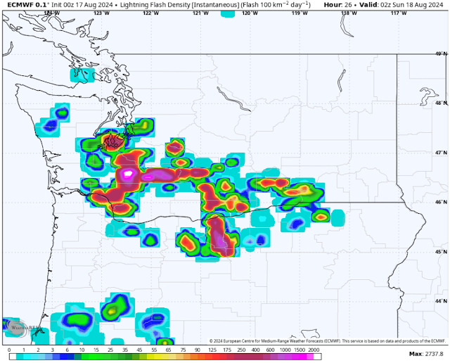
First, the thunderstorms...below is the HRRR forecast for potential lightning on Thursday night.

This forecast shows an area of storms moving from SE to NW across the coastal mountains of WA & OR, then moving over the Washington coast. This area of potential storms has also been forecasted from Tacoma to Olympia on previous model runs, and that area remains in play for possible storms on Thursday night.
There is another chance of thunderstorms on Friday, specifically in the afternoon. Below is the HRRR forecast for lightning late Friday afternoon.

This forecast shows scattered areas of storms across Eastern WA, the Cascades, and the metro area from Tacoma northward through the San Juans and BC. This storm chance is less certain, and storms could pop up in different Western WA locations than shown on this map.
Now, for temperatures, let's take a look at the NWS NBM forecast for highs on Saturday.

On Saturday, highs in Western WA will only reach the low to mid 60s, while the Willamette Valley and Eastern WA only reach the upper 60s to low 70s. These temperatures are 10-15° below average for this time of year. That is due to the upper-level low bringing in much colder air (both aloft and at the surface).
That will be reflected in morning lows, as seen on the NWS NBM model below.

On Saturday morning, while Western WA remains mostly seasonable in the low to mid 50s, areas in the mountains and highlands of E. OR will drop to the mid 30s to low 40s, while Eastern Washington will get chilly, down to the mid 40s to low 50s.
Remember to take it slow, watch for standing water/ponding, and be prepared for isolated thunderstorms!
Monday, August 19, 2024
Wetter & Unsettled Weather Continues
Special Note--Thank you so much to everyone who has joined my new Western Washington Weather Facebook group over the past few days! In under one week, over 330 people have joined! Please keep sharing the group so we can get even more folks engaged with our weather! Join by clicking the Facebook logo to the right, then hit "join"!
--Matthew
-------------------------------------------------------------------
FastCast--Tuesday, Aug. 20 to Saturday, Aug. 24:
After multiple days with thunderstorms across the region, cooler, wetter, and generally unsettled weather will continue across Washington. Expect showers at times across the lowlands on Tuesday, with rain totals of 0.05-0.2". More showers are possible on Wednesday into Thursday, with grand totals of 0.3-0.5" across the lowlands by late Wednesday. There is also a low chance of thunderstorms in Western Washington on Tuesday afternoon, with brief thunder/lightning, heavy rain, and possible gusty winds in any thunderstorms. A similar thunderstorm threat is possible Wednesday into Thursday, but is more uncertain. Yet more rain is possible later in the week, but the details of the upper-level pattern are still evolving, and those details will determine rain amounts and coverage. Meanwhile, temperatures will remain on the cool side for this time of year, with highs in the upper 60s to low 70s across the region for the entirety of this week. However, with a decent amount of clouds around, overnight lows will remain in the upper 50s for the metro area, with outlying areas dropping to the mid 50s.
------------------------------------------------------------
Continue reading the full blog below!
After an active few days across the Northwest, unsettled (but somewhat calmer) weather will prevail. Let's take a look at the forecast!
We'll start with the European model forecast for total rain through Wednesday night, seen below.

This forecast shows the lowlands receiving 0.1-0.25" of rain due to scattered showers on Tuesday and Wednesday. The Kitsap Peninsula, where there is a potential for stronger showers, may get up to 0.3-0.5". Notice that more persistent rain will be found on the coast and in the Olympics, with up to 0.5-1.25" through Wednesday.
Let's compare this to the NWS NBM high-resolution forecast for total rain through Wednesday.

This forecast shows more widespread rain across the lowlands, with higher totals of 0.3-0.5" region-wide. The coast and Olympics get 0.5-1.1" in this forecast, with the Cascades getting 0.5-0.75".
There is also another thunderstorm threat on Tuesday afternoon, as seen in the European model lightning forecast below.

This forecast shows a potential for thunderstorms over the lowlands, especially from Seattle south toward Olympia and along Hood Canal. This setup is a more typical (and thus, more fickle) thunderstorm setup for the Northwest, and models are somewhat inconsistent on storm development. Be on the lookout for potential storms Tuesday afternoon, and remember to seek shelter indoors or in a vehicle during thunderstorms.
Finally, let's take a look at temperatures on Tuesday, seen below on the NWS NBM model.

On Tuesday, expect lowland highs in the upper 60s to mid 70s, coastal highs in the mid to upper 60s, and Willamette Valley highs in the upper 70s to low 80s. Eastern Washington will reach the low to mid 80s.
Next, here's a look at Wednesday.

Wednesday gets cooler region-wide. The lowlands will reach the upper 60s to low 70s, the coast will reach the low to mid 60s, the Willamette Valley will reach the mid 70s, and Eastern Washington will cool to the mid 70s to low 80s.
Finally, here's a look at Thursday's high temperatures.

On Thursday, Western Washington remains cooler, while Eastern WA heats up again. Expect lowland highs to reach the low to mid 70s, coastal highs to reach the mid 60s to low 70s, and Willamette Valley highs to reach the low 70s. Eastern Washington will be warming up, with highs in the upper 70s to upper 80s.
Stay tuned over the next few days as more active weather is possible!
Saturday, August 17, 2024
Saturday Evening Thunderstorm Update
A significant thunderstorm event looks likely across Western Washington from Saturday evening into early Sunday morning. This blog post will be an update on all the threats possible tonight...lightning, rain, and wind.
What You Need to Know:
- Strong thunderstorms will impact the region tonight
- Approximate timing:
- Portland: 4-7 PM
- Olympia: 7-11 PM
- Seattle/Tacoma: 8-11 PM
- Skagit/Island/Whatcom Counties: 10 PM-12 AM
- Vancouver, BC: 11 PM-1 AM
- Storms will contain heavy rain (0.5-1.5" possible), urban flooding is possible
- Severe winds (58+ mph) are a risk per the NWS, and the lowlands may see gusts as high as 40-50 mph, with some isolated parts of WA reaching 55-60 mph (mainly E. Columbia River Gorge)
- Be prepared for tree damage and power outages...charge your devices and secure outdoor furniture
--------------------------------------------------------------------------------
Let's dive into the details!
We'll start with the forecast for simulated radar imagery at 8 PM. This tool allows me to compare the NAM and HRRR models next to each other.

The NAM is on the left and HRRR is on the right. At 8 PM, the NAM shows storms still somewhat disorganized and mainly over the Cascades. Meanwhile, the HRRR shows a strong line of thunderstorms moving north into the metro area.
Next, here's 9 PM.

At 9 PM, the NAM shows some storms moving into the Seattle area, with the main band moving in from the SE, located from Chehalis to Pasco. Meanwhile, on the right, the HRRR shows the main storms as far north as Everett by 9 PM, with strong storms still impacting the Sound down to Olympia.
Let's keep going, now looking at 10 PM.

At 10 PM, the NAM (left) shows the main area of storms moving into the lowlands, and also shows another area of strong storms over the Cascades and Eastern WA (from Ellensburg to Ritzville). Meanwhile, the HRRR shows much less over Eastern WA, with storms reaching Island and Skagit Counties by 10 PM.
Finally, here's a look at 11 PM.

At 11 PM, the NAM shows strong thunderstorms slamming the Seattle region, with the northern boundary near Bellingham. The HRRR (right) shows storms reaching the Olympic Peninsula and Bellingham, with more rounds of storms moving NW coming up from Oregon, plus a line of storms still over the Cascades.
Due to the potential for severe thunderstorms with severe wind gusts, the NWS Storm Prediction Center has issued a rare marginal risk for the Seattle and Portland metro areas. Today's outlook is below.

For the first time since May 4, 2017, there is a marginal severe thunderstorm risk for the Seattle region. This threat has been issued mainly due to the potential for severe wind gusts (58+ mph, by definition).
With this wind being a potential threat, be sure to have your devices charged, take in vulnerable outdoor furniture, and be prepared for tree damage and power outages.
Now, let's switch gears and take a look at wind gust potentials. The HRRR's latest run shows a significant wind event for Western Washington due to the strong thunderstorms moving through.

This forecast is concerning, showing wind gusts of 40-55 mph across the Puget Sound lowlands, from Olympia northward to Skagit County. Whatcom & San Juan Counties could see gusts up to 50-60 mph, and parts of Eastern WA (mainly along the eastern slopes of the Cascades) will gust 40-60 mph, with the strongest gusts, possibly up to 50-70 mph, along the Columbia River Gorge from The Dalles toward Hermiston.
However, this forecast is definitely on the strong side. Below is the NAM forecast, showing an event with lesser winds.

This forecast shows lesser winds across Western Washington, with isolated areas hitting 30-35 mph. The NAM shows Eastern WA gusting 40-50 mph, strongest east of The Dalles.
Another big threat with this thunderstorm event is rainfall. A significant amount of rain will fall in a short amount of time, which is a cause for concern. Below is the HRRR forecast for rain through early Sunday morning.

This forecast shows areas from Chehalis to Whidbey Island receiving 0.5-1.3" of rain, most between Olympia and Seattle. Some areas could receive nearly 1" of rain in a matter of hours.
Let's compare this to the NAM high-resolution forecast, which is even more ominous.

This forecast shows very heavy rainfall over the lowlands, with areas from Tacoma to Whidbey Island receiving 0.75-1.5" of rain, which would cause urban flooding if it verified. The Cascades receive 1-3", which would bring a significant risk of landslides and debris flows in burn scar areas, along with small stream flooding.
In conclusion, there is a triple threat of lightning, wind, and rain tonight. Be sure to not be outside during the storms...stay either in a vehicle or in a sturdy building. For the latest updates during the storms, follow along in my Western Washington Weather Facebook group. And, of course, enjoy the storms! This doesn't happen too often around here!
Friday, August 16, 2024
Update: Significant Thunderstorm Event Likely for Western Washington
No FastCast tonight...continue reading below for the latest update on the upcoming thunderstorm event.
At 7 PM, the European model shows a line of storms moving north through the southern portions of WA, having just passed through the Portland metro area. At this time, storms are beginning to move into the Olympia and Tacoma areas, with stronger storms moving northward through Lewis and Cowlitz counties.

By 8 PM, a significant thunderstorm is slamming the metro area from Seattle south through Olympia. This would have frequent lightning, heavy rain, and strong winds. It is very rare to see this kind of forecast for Western Washington!

By 9 PM, the line of storms stretches from the Central WA Coast toward the Cascades, with strong thunderstorms impacting the Seattle metro area. This shows a very significant thunderstorm event for the metro area.

The HRRR shows storms impacting the metro area starting around 8-9 PM, continuing for 3-4 hours after that.

The NAM has a similar-looking radar image as the HRRR does, but shows storms moving into the metro area a bit later, around 9-10 PM.

This forecast shows significant, dangerous totals in the Cascades, with 1-3" for the Washington Cascades, including over burn scars, which could bring debris flows and flash flooding. Over the lowlands, this forecast shows 0.6-1.25" of rain from Olympia to Everett, and 0.15-0.4" elsewhere. This is significant for summer, and will bring standing water and potential urban flooding.

This forecast shows storms moving more south to north vs. the NAM, which shows more SE to NW movement. The European model gives the I-5 corridor from Chehalis to Arlington 0.6-1.1", with the rest of Western WA getting 0.3-0.7", most on the Kitsap Peninsula. Isolated mountain locations could get over 1.1".

This is extremely rare! This outlook shows a marginal (dark green) risk of severe thunderstorms for Portland, most of King and Pierce Counties, and most of the WA Cascades. An even rarer slight risk (yellow) is in place for the Southern WA Cascades and Oregon Cascades.
A significant thunderstorm event looks likely across Washington & Oregon on Saturday, possibly stretching into Sunday morning. We'll take an in-depth look at the forecast in this blog post, with another update by midafternoon Saturday.
Let's start with the European model forecast for lightning. This first frame is for 7 PM Saturday.

At 7 PM, the European model shows a line of storms moving north through the southern portions of WA, having just passed through the Portland metro area. At this time, storms are beginning to move into the Olympia and Tacoma areas, with stronger storms moving northward through Lewis and Cowlitz counties.
Next, here's a look at the forecast for 8 PM.

By 8 PM, a significant thunderstorm is slamming the metro area from Seattle south through Olympia. This would have frequent lightning, heavy rain, and strong winds. It is very rare to see this kind of forecast for Western Washington!
Let's continue onward, now to 9 PM.

By 9 PM, the line of storms stretches from the Central WA Coast toward the Cascades, with strong thunderstorms impacting the Seattle metro area. This shows a very significant thunderstorm event for the metro area.
After this, storms will likely begin weakening and moving north, with uncertainty remaining about another potential round of scattered storms impacting the metro area from 12-4 AM Sunday.
However, uncertainty remains about what time storms will impact the metro area. We'll take a look at the HRRR and NAM high-resolution forecasts to see more about timing. These forecasts are essentially simulated weather radar, showing what the radar could look like as the thunderstorms move in.
First, the HRRR high-resolution forecast.

The HRRR shows storms impacting the metro area starting around 8-9 PM, continuing for 3-4 hours after that.
Let's compare to the NAM forecast, seen below.

The NAM has a similar-looking radar image as the HRRR does, but shows storms moving into the metro area a bit later, around 9-10 PM.
Basically, storms are most likely from Olympia northward in the 8-11 PM timeframe, potentially continuing into early Sunday morning (becoming more scattered). For more frequent updates, join the Western WA Weather Facebook group (click here or the logo on the right side of the blog).
There are more threats than just lightning with these thunderstorms. The biggest additional threats are rain and wind. Wind is very difficult to predict, and there is still significant model disagreement on what will actually happen. Stay tuned for future updates regarding wind potential.
Below is the NAM high-resolution forecast for total rain through Sunday.

This forecast shows significant, dangerous totals in the Cascades, with 1-3" for the Washington Cascades, including over burn scars, which could bring debris flows and flash flooding. Over the lowlands, this forecast shows 0.6-1.25" of rain from Olympia to Everett, and 0.15-0.4" elsewhere. This is significant for summer, and will bring standing water and potential urban flooding.
Let's compare this to the European model's rainfall forecast, seen below (also through Sunday).

This forecast shows storms moving more south to north vs. the NAM, which shows more SE to NW movement. The European model gives the I-5 corridor from Chehalis to Arlington 0.6-1.1", with the rest of Western WA getting 0.3-0.7", most on the Kitsap Peninsula. Isolated mountain locations could get over 1.1".
Finally, let's take a look at the NWS Storm Prediction Center (SPC) outlook for Washington.

This is extremely rare! This outlook shows a marginal (dark green) risk of severe thunderstorms for Portland, most of King and Pierce Counties, and most of the WA Cascades. An even rarer slight risk (yellow) is in place for the Southern WA Cascades and Oregon Cascades.
What does this mean? The SPC is noticing the potential that thunderstorms will be strong enough to be severe-warned, which means wind gusts could exceed 58 mph, and there could be large hail (likely confined to the mountains, if at all).
Wow!! That's a lot of information! If you've made it this far, thanks for reading all the way! Stay tuned on Facebook for more information and frequent updates. I will have one final blog post update by midafternoon Saturday.
In the meantime, don't forget to keep your devices charged, as thunderstorms can cause power outages, especially when there's a wind component. Stay tuned!
Thursday, August 15, 2024
Region-Wide Thunderstorm Event Possible This Weekend
No FastCast tonight…continue reading the full blog below!
Special Note: The 2620 Road/Jupiter Fire is burning on the slopes of Mt. Jupiter, west of Brinnon (on Hood Canal), and near the Duckabush valley and Dosewallips State Park. As of 10:00 PM Thursday, the fire has burned 350 acres and is 0% contained. This fire has been visible from the Seattle metro area, and will likely continue to be active on Friday. Stay tuned to local authorities (WA DNR & the Brinnon Fire Department) for updated information.
——————————————————————————
A potentially significant thunderstorm event is looking likely this weekend across Washington. We’ll take a look at the forecast and approximate timing of this event in tonight’s blog post, and will nail down more exact details in an update either Friday night or Saturday morning, so stay tuned.
We’ll start with the forecast for the upper-air pattern (at 10,000 feet) early Sunday morning, from the European model. This is very important to understanding this thunderstorm event.

Notice how the lines over the lowlands go from SE to NW, indicating SE flow aloft. This is what will allow for thunderstorms to move through the region.
Now, let’s get to the thunderstorm forecast. We’ll start with the forecast for where thunderstorms will be on Saturday afternoon. This is from the European model.

On Saturday afternoon, the best chance for thunderstorms will be over the Willamette Valley, Oregon Cascades, and off the WA/OR coast. The thunderstorm threat is moving into the lowlands, with higher chances over the Olympics & Cascades.
Next, let’s take a look at the thunderstorm potential for Saturday night.

Now this is something…this shows a significant thunderstorm event, with heavy rain and frequent lightning, across the Puget Sound lowlands, Washington Cascades, and most of northern Oregon. This would be a memorable thunderstorm event if this verified.
Finally, here’s a look at early Sunday morning, as the thunderstorm activity begins diminishing and moving north out of the region.

Early Sunday morning, activity gets confined to parts of the lowlands and the east slopes of the Cascades. The European model likely underestimates the potential for thunderstorms over areas from Everett northward. We’ll take a more in-depth look at this in my next blog.
This is a very interesting forecast, with a very high thunderstorm potential across the region. The thunderstorm events of the past few weeks (mainly confined to the mountains and Eastern WA) have been notable for their lack of rainfall, and therefore, a high chance of starting fires. However, this is not the case with the weekend event.
Below is the European model forecast for total rain through Sunday.

This forecast shows most of the region from Portland to Everett getting 0.3-0.7” of rain, more than the past 2 months for much of the area.
Let’s compare this to the NWS NBM high-resolution forecast, which has a somewhat different solution (also showing rain through Sunday).

This forecast implies that thunderstorms will move northward across the region in a more uniform fashion than the European model shows. In this forecast, all areas west of the Cascades receive 0.3-0.7” of rain, with isolated higher totals in the WA Cascades and Olympics.
This rain would be beneficial, and would help to significantly decrease the threat for new fires started by lightning. However, with a lack of rain predicted for most of Eastern Washington (generally under 0.1”), any thunderstorms east of the Cascades may have a chance to spark new fires.
A very important thing to note is that as usual with our thunderstorm events, everything is still quite uncertain. The most uncertain aspect is how the storms will move through (either multiple rounds or one big area of thunderstorms), how much rain will fall, and how strong any thunderstorm-related winds will be.
One prediction is found below, on the NAM high-resolution model. This is basically showing predicted weather radar on Saturday night.

The NAM shows a huge area of thunderstorms, stretching roughly from Lake Quinault to Moses Lake, moving northward across Washington on Saturday night. Other forecasts (like the European) show a feature like this, preceded by scattered storms.
More high-resolution models will be in range over the next 24-36 hours, and I’ll use those in my next blog, either Friday night or Saturday morning.
In the meantime, you can follow along on my Twitter/X page, the Pacific Northwest Weather Watch YouTube channel (both on the right side of the blog under “Helpful Weather Websites”), or my brand-new Facebook group for Western Washington Weather! Click the large Facebook logo on the top right of the blog page to access the group. If you have a Facebook account, please join the group so you can follow along with even more updates and share what weather is happening at your location!
Sunday, August 11, 2024
Cooler, More Seasonable Conditions Due to Pattern Change
FastCast--Monday, Aug. 12 to Friday, Aug. 16:
A pattern change will bring more seasonable conditions to Western Washington this week. Expect partly to mostly cloudy conditions on Monday and Tuesday, with AM clouds and PM sun on Wednesday. Partly to mostly cloudy conditions will return Thursday and Friday, with potential chances of drizzle near the coast on Monday and a regionwide slight chance of showers late Friday. Temperatures will reach the low to mid 70s on Monday and Tuesday, increasing to the mid to upper 70s on Wednesday. Temperatures return to the low to mid 70s on Thursday, before likely decreasing to the upper 60s to low 70s on Friday. Low temperatures will remain in the mid to upper 50s through Friday.
-------------------------------------------------------------------
Continue reading the full blog below!
After most of summer has been above normal temperature-wise, more seasonable conditions are ahead. Let's take a look at the forecast!
We'll start with the overall pattern, with the European ensemble forecast below.

This forecast, for Monday, shows troughing across the Northwest. With the absence of high pressure ridges, cloudier and cooler conditions will prevail across the Northwest.
We'll take a look at high temperatures next, starting with the NWS NBM forecast for Monday's highs.

On Monday, expect lowland highs in the upper 60s to mid 70s. The coast will reach the low to mid 60s, and the Willamette Valley will reach the mid to upper 70s. Eastern Washington will reach the upper 80s to low 90s.
Next, here's Tuesday's highs.

Tuesday will be similar, or slightly cooler, than Monday, with lowland highs in the upper 60s to low 70s, coastal highs in the low to mid 60s, and Willamette Valley highs in the mid to upper 70s (isolated low 80s). Eastern Washington will cool further, to the low to mid 80s.
Finally, here's a look at Wednesday, likely the warmest day of the week.

On Wednesday, the lowlands will reach the mid to upper 70s, except the upper 60s to low 70s near the water. The coast will reach the mid to upper 60s, the Willamette Valley will reach the low 80s, and Eastern Washington will reach the low to mid 80s, with isolated highs in the upper 80s.
Additionally, wildfire smoke will continue to be an issue in Eastern Washington. The pattern bringing cooler & cloudier conditions to Western WA pushes surface smoke eastward. Below is the HRRR forecast for surface smoke on Monday morning.

This forecast shows moderate concentrations of surface smoke across Eastern Washington, likely bringing "unhealthy for sensitive groups" to "unhealthy" air quality.
By the evening, the smoke plume from the Williams Mine Fire will be impacting southern parts of Eastern WA, as seen below.

Notice the large smoke plume from the Williams Mine Fire and smaller plumes from the Pioneer and Ruby Fires in the north-central Cascades. Expect this to bring moderate to heavy concentrations across Eastern Washington, including the Tri-Cities/Walla Walla and the Spokane region, especially from Monday night to Tuesday morning.
Lastly, let's take a look at the general conditions possible over the next couple weeks. We'll look at the NWS Climate Prediction Center outlooks for mid-August.

For August 17-21, these outlooks show a 40-50% probability of below average temperatures, and a 50-60% probability of above average precipitation. This is due to a potential wetter pattern by the end of the week. Stay tuned for more!
Thursday, August 8, 2024
Heat Wave, Smoke Incursion, and Possible Thunderstorms for Western WA
The forecast remains on track from this blog post. No update Thursday night.
A heat wave, surface and elevated smoke, and a chance of thunderstorms are all ahead for Western Washington. Light concentrations of surface smoke (along with moderate to heavy smoke aloft) will be present across Western Washington from early Thursday through at least Friday. This will bring degraded air quality in the “moderate” to “unhealthy for sensitive groups” categories in the lowlands. Use the link under “Helpful Weather Websites” on the right side of the blog for updates. Heat will peak on Thursday and Friday, with lowland highs in the low to mid 80s from Everett north and in the upper 80s to low 90s from Everett south. Temperatures decrease to the upper 70s to mid 80s (hottest south of Seattle and away from water) on Saturday, then down to the mid to upper 70s regionwide on Sunday. Low temperatures through Saturday will remain warm, in the low to mid 60s, which isn’t great due to potential degraded AQI. Additionally, there is a chance of thunderstorms in the Cascades on Thursday and Friday, with that chance potentially extending into the lowlands on Friday afternoon. Stay tuned for more information about that chance, and keep reading below for more information on the upcoming weather impacts.
———————————————————————
Continue reading the full blog below!
Smoke is heading back into Western Washington. The biggest contributors to the smoke will be the Williams Mine Fire (4,500 acres near Mt. Adams), the Retreat Fire (45,500 acres west of Naches), and for some of northern WA, the Calcite Creek Fire in BC.
We’ll start with the forecast for smoke aloft on Thursday morning from the HRRR model.

This forecast shows moderate to heavy concentrations of smoke aloft for Western WA and Western OR on Thursday morning. The sun will likely be very red across the region.
By Thursday evening, large plumes of smoke from fires in WA, OR, and BC are pumping tons more smoke into the atmosphere.

Take note of moderate to heavy smoke concentrations aloft from the Seattle area south through central Oregon. The plumes from the Retreat and Williams Mine Fires are producing large amounts of smoke across south-central WA.
By Friday morning, the smoke plume from the Williams Mine Fire is predicted to drape smoke aloft across Western Washington and Oregon.

This will bring quite a red tint to the sun across the region, and is also indicative of significant growth on the Williams Mine Fire.
Now, let’s shift gears from smoke aloft to surface smoke. This is what impacts AQI. Below is the forecast for surface smoke around midday Thursday.

By midday Thursday, light concentrations of surface smoke are present across Western WA, with moderate to heavy concentrations for the Portland metro area due to the Williams Mine Fire.
Next, here’s surface smoke by Thursday evening.

Notice the smoke plumes from the Retreat Fire and Williams Mine Fire are blowing westward into Western WA. This is the reason for light surface smoke concentrations that will continue through Thursday. Don’t be surprised if you smell wildfire smoke, with air quality in the “moderate” to “unhealthy for sensitive groups” categories.
Next, let’s take a look at the very hot temperatures for the next couple days. Below are Thursday’s highs from the NWS NBM forecast.

This forecast shows highs from Everett north reaching the low to mid 80s, and from Everett south reaching the upper 80s to low 90s. The Willamette Valley reaches the mid 90s, and Eastern Washington reaches the upper 80s to upper 90s. The coast will remain comfortable, in the upper 60s to mid 70s (isolated upper 70s inland).
Next, here’s Friday’s highs, also from the NWS NBM model.

Notice cooler temperatures moving inland on Friday, with the coast down to the mid 60s to mid 70s (hottest inland). Areas from Everett north will reach the upper 70s to mid 80s, while areas from Everett south will again reach the upper 80s to low 90s. The Willamette Valley will reach the upper 80s to low 90s, and Eastern Washington will reach the upper 80s to upper 90s.
One thing to note with temperatures is that smoke can keep temperatures a few degrees cooler than what is forecast, especially if it’s thick smoke aloft.
Finally, let’s take a look at thunderstorm potential on Thursday and Friday. Below is the European model lightning forecast for Thursday afternoon.

There’s a chance of thunderstorms for the Cascades, mainly from Snoqualmie Pass northward, parts of NE WA and the Oregon Cascades.
However, Friday is a different animal. Below is the lightning forecast for Friday afternoon.

The overall environment is very unstable on Friday, with high lightning potential for almost the entirety of the Washington Cascades, the Olympics, and mountains in Oregon including the Cascades and Blue Mountains.
Additionally, note that the thunderstorm chances over the Olympics spread into Central Puget Sound and the Kitsap Peninsula. Lowland thunderstorms aren’t out of the question with this setup.
Stay tuned for more information Thursday night, as this setup gets closer!
Subscribe to:
Posts (Atom)
Next Storm System Hits Western Washington
8-26 Video Briefing: Next Storm System Hits Western Washington
