Monday, August 30, 2021

Ida’s Aftermath & Calm Weather in the Pacific Northwest

At 10:55 AM CDT on Sunday, Hurricane Ida made landfall near Port Fourchon, Louisiana, as a 150 mph, 930 mb, Category 4 hurricane. 

Ida had many devastating impacts. 2 people have died as of Monday evening, and over 1 million customers remain without power in Louisiana. Wind gusts of 75-170 mph were recorded around Louisiana. Storm surge of 10+ feet and 10+ inches of rain were recorded as well. 

Below is an image from weather.com of the town of Laplace, LA, which was completely flooded due to a levee failure during Ida.


One of Ida’s biggest impacts was knocking out power to the entire city of New Orleans. The weather.com photo below shows a major transmission feeder line that was knocked over as winds gusted 90-100 mph.


New Orleans authorities called this a “catastrophic” failure. A major transmission line failure like this can cause thousands to millions of people to lose power (failures such as this have happened, on a lesser scale, in some of the great Pacific Northwest windstorms).

The NWS map below shows peak wind gusts in SE Louisiana, ranging from 90 mph at New Orleans Int’l Airport to 128 mph in the Mississippi Delta.


Unofficial reports suggest gusts of 100-172 mph in coastal areas of SE Louisiana. Any way you look at it, Ida was one of Louisiana’s most devastating hurricanes, and it will be months until the area has fully recovered. Many residents face having no power for days to weeks following the storm.

Ida, now a Tropical Depression, is moving NE through the Mississippi Valley and Mid-Atlantic, and will accelerate offshore over the Northeast by Thursday.

Keep those impacted by Ida in your thoughts and prayers. For more information on Ida’s impacts and frequent updates on the situation, visit weather.com.

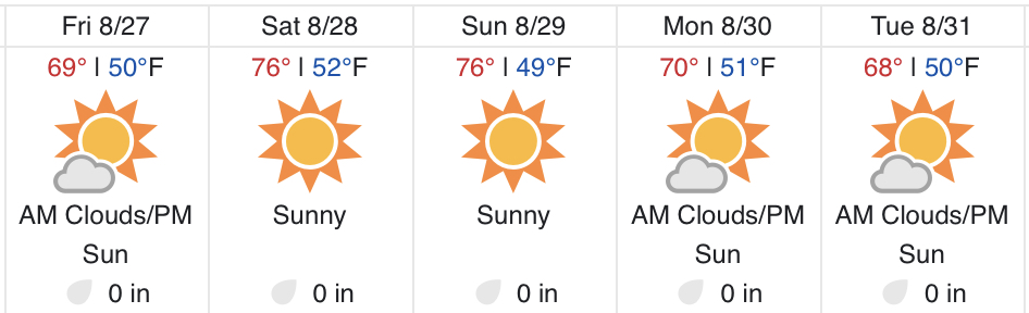
Transitioning to the Pacific Northwest…calm weather is expected to start September. Below is the Weather Underground forecast for Federal Way.


Some showers are possible through early Tuesday, then it gets sunnier, with highs in the low 70s on Wednesday, warming to upper 70s-low 80s by the end of the week. Expect morning lows in the mid 40s to low 50s. Showers and slightly cooler weather return by the weekend.

Saturday, August 28, 2021

Hurricane Ida Heading for the Gulf Coast

Hurricane Ida is less than 24 hours from making landfall in Louisiana. As of the 10 PM CDT (Saturday) advisory, Ida was a 105 mph Category 2 hurricane. The center was located about 220 miles SE of New Orleans. The satellite image below from Tropical Tidbits shows strengthening Ida on Saturday night.


Ida’s eye is starting to clear out, and pressure is falling rapidly. These are two signs that Ida is strengthening. Winds, currently at 105 mph, will likely increase all the way until landfall.

Below is the official forecast from the National Hurricane Center for Ida (as of the 10 PM CDT advisory on Saturday).


Rapid intensification is expected, with Ida likely becoming a Category 4 hurricane with sustained winds of 130 mph by landfall (Sunday afternoon to night).

Areas near the core of Ida will likely experience sustained winds of 70-100 mph with gusts of 80-130 mph. (Wind speeds are much lower over land vs. water due to increased drag & friction). Power outages will be widespread and damage will be substantial.

A major and catastrophic facet of Hurricane Ida will be the storm surge. Onshore winds will cause water to essentially “pile up” along the coastline of the Central Gulf Coast, seen in the NHC graphic below.


This is incredibly dangerous storm surge. The worst surge will be from Burns Point, LA to the Mississippi/Alabama border, where 6-15 feet of surge is expected. This includes Lakes Pontchartrain and Maurepas, where 4-8 feet of surge is likely. 

In the map below, all areas shaded orange or red will have surge greater than 6-9 feet above ground.


White hashed areas are protected by levees. This includes Metro New Orleans, but surge greater than 9 feet above ground will occur all around the city. 9+ foot surge will also be found along parts of the Mississippi Delta, the north shore of Lakes Pontchartrain & Maurepas, and the coast from the Delta to around Gulfport, MS.

Extreme wind & devastating storm surge will not be the only impacts from Hurricane Ida. Very heavy rainfall will extend well inland. The graphic below shows expected total rain from Ida.


Areas shaded in red and magenta will receive a whopping 10-20 inches of rain, including New Orleans & Baton Rouge. Freshwater flooding & flash flooding is likely.

Overall, Hurricane Ida is a very dangerous situation for the Central Gulf Coast. Stay tuned to the National Hurricane Center for the latest updates on the storm, and keep those in Ida’s path in your thoughts & prayers.

Thursday, August 26, 2021

Showers in Western Washington & Below Average Temperatures Ahead

It is rare to be able to count the number of times it has rained in Seattle on one hand…but that’s exactly what has happened this summer. At my weather station in Federal Way, Thursday was only the 2nd day with measurable rain since June 16th. 

Rain fell in many locations in the Central Sound, but a rain shadow is evident on the 24 hour precipitation map ending at 10 PM Thursday.


Most areas east of Puget Sound received 0.01-0.15 inches, good enough to wet most surfaces and freshen things up. Areas around Everett (Convergence Zone) and in the Cascades received 0.15-0.5 inches.

Looking ahead, some more rain is possible through Friday, but only from Everett northward and in the mountains. The UW forecast is below.


Cooler air moved in behind the cold front that produced Thursday’s rain. This cooler air will be present on Friday before temperatures warm up a bit for the weekend. The Weather Underground forecast for Federal Way is below.


Expect morning clouds on each day but the weekend. Highs will be in the upper 60s to low 70s, except in the mid 70s on the weekend…perfect weekend weather in my opinion. Cool morning lows in the upper 40s to low 50s are likely for the foreseeable future.

Additionally, for the first time in a very long time, the NWS Climate Prediction Center is forecasting below average temperatures for the Pacific Northwest! Below is the 6-10 day temperature outlook for September 1st-5th.


The outlook shows a 40-50% chance of below average temperatures for all of Washington State. The cooler weather is welcome after a hot and dry summer…enjoy it!

For information on Tropical Storm Ida, (threatening the Gulf Coast as a major hurricane this weekend), click below:

https://www.nhc.noaa.gov/#Ida

Wildfire Updates: https://inciweb.nwcg.gov/

Tuesday, August 24, 2021

Smoke Drifts Back Into Western Washington & Noticeably Cooler Mornings

You likely noticed 2 weather-related things on Tuesday…some smoke in Western Washington and the coldest morning in over 2 months. This blog will talk about both of them, plus a chance of rain on Thursday and Friday.

Smoke is visible behind the Seattle skyline in this photo I took Tuesday evening on the ferry from Bremerton.


This smoke came from fires in Eastern Washington, and due to the short distance it traveled to get here, it was aloft and near the surface, resulting in briefly degraded AQI in the “moderate” category and the occasional smell of smoke, as well as hazy skies. 

Let’s quickly take a look at the smoke forecast. First off…near-surface smoke shouldn’t be an issue from Wednesday onward, and air quality will remain in the “good” category. 

Below is the forecast smoke aloft at 7 AM Wednesday.


More smoke from Eastern Washington has moved across the Cascades, particularly from the Schneider Springs Fire (has burned 68,193 acres ~20 miles NE of Naches, 3% contained as of Tuesday night).

By 2 PM Wednesday, westerly winds have begun to blow away the smoke.


And finally, by 7 AM Thursday, our air is smoke-free once again!


Below is the Weather Underground forecast for Federal Way.


The warmest day in awhile will be Wednesday, with highs in the upper 70s to low 80s. Clouds return from late Wednesday to late Friday. There is a chance of showers on Thursday (Seattle southward will be a bit rain-shadowed…see rain map below for more details). Thursday and Friday’s highs will be in the upper 60s to low 70s. Sun returns for the weekend, with highs in the mid 70s, quite comfortable for Western Washington! 

Below is the UW rain forecast through 5 PM Friday.


0.01-0.1 inches of rain is possible for most of Western Washington, with 0.1-0.5 inches possible north of Everett and in the Cascades. We need all we can get!

Now…if you saw on the forecast shown previously, low temperatures will generally stay in the low-mid 50s. This is cooler than late June, July, and most of August’s lows. Tuesday morning was the coolest morning since mid June (before the extreme heat wave), with lows in the low 40s to low 50s across Western Washington, and as cold as the upper 30s in the Cascades! Tuesday’s lows are below.


It sure felt chilly out! Expect lows mainly in the low 50s to continue into the start of September, a bit colder in valleys and particularly outlying areas. For those of you weary after a hot & dry summer, let this be a reminder that fall is approaching!

Saturday, August 21, 2021

Cooler in Western Washington, Hurricane Henri Approaching New England

The past couple days have been refreshing in Western Washington! Highs have reached the upper 60s to mid 70s, quite nice after many days 80°+.


Cooler weather is expected to continue in Western Washington for the next few days. Below is the Weather Underground forecast for Federal Way.


Sunday and Monday will be in the upper 60s to low 70s, with lows in the upper 40s to low 50s. These will be the “coolest” nights in awhile! Highs increase to the mid-upper 70s on Tuesday and Wednesday, then decrease to the lower 70s on Thursday. Lows remain in the low-mid 50s through at least Thursday.

Important note: A La Niña pattern is currently in the forecast for the Pacific Northwest this winter. This generally means cooler temperatures, more mountain snow, more rain, and a higher possibility of lowland snow. To find out more, check out Cliff Mass’s blog below:

https://cliffmass.blogspot.com/2021/08/a-potential-la-nina-for-this-winter.html

Now to the big weather story in the US…Hurricane Henri (pronounced “ahn-REE”) is moving north toward New England. Below is the Saturday evening satellite image from Tropical Tidbits (Henri in the box).


Below is the official forecast from the National Hurricane Center (NHC) as of 11 PM EDT (8 PM PDT).


A landfall on eastern Long Island is likely on Sunday, with Henri as an 80 mph Category 1 hurricane, the first hurricane to hit New England since Bob in 1991. Henri will begin weakening and move into Connecticut, Rhode Island, and Massachusetts as a tropical storm. 

A big issue along the coastal areas of New England will be storm surge. The NHC surge forecast is below.


Storm surge up to 3-5 feet is forecast from Long Island Sound to Nantucket Island, and beach erosion is possible from New Jersey to Massachusetts. 

Additionally, 2-10 inches of rain will fall in New England as Henri moves through. Flooding is expected.

You can keep up with Henri’s progress at the links below:

National Hurricane Center: Hurricane Henri

HurricaneTrack YouTube Channel (Mark Sudduth: experienced hurricane chaser with live streaming camera)

The Weather Channel Twitter

———————————————————————

Keep up with wildfires: https://inciweb.nwcg.gov/

Thursday, August 19, 2021

Washington State Wildfire Update

In the past few weeks, conditions across the Cascades and Eastern Washington have been favorable for many new wildfires to start, many of which have grown significantly after starting. This blog will take a look at 10 fires across the state.

Schneider Springs Fire: 56,422 acres (as of 1:30 PM Thursday), (31,868 acres at original writing of blog)

This fire was started by lightning on August 4th and is burning approximately 20 miles northeast of Naches. The map below shows its location.

Favorable winds have generated large pyrocumulus smoke plumes, as seen in the satellite image below from the afternoon of August 18th.


The fire will continue to spread and large smoke plumes are likely to continue for at least the next few days.

Updates & photos found here: https://inciweb.nwcg.gov/incident/7775/

Green Ridge Fire: 38,410 acres, 29% contained

This fire started due to lightning on July 7th, and has been growing slowly ever since. It has expanded enough to run into the Lick Creek Fire scar, which has slowed burning on the east side. The map below shows the Green Ridge Fire and Lick Creek Fires, which are both located in rural SE Washington (between Walla Walla and Lewiston, ID), not threatening towns.


A black line on the perimeter of a fire indicates containment, and a red line indicates the fire’s current perimeter.

Lick Creek Fire: 80,421 acres, 97% contained

In an earlier blog, I talked about this fire as it was initially growing as the Asotin Complex. It has now grown to over 80K acres and is the largest fire of the year so far in Washington State. It is very near full containment after being started by lightning on July 7th and rapidly growing in the following weeks.

Green Ridge updates: https://inciweb.nwcg.gov/incident/7628/

Lick Creek updates: https://inciweb.nwcg.gov/incident/7615/

Ford Corkscrew Fire: 15,019 acres, 14% contained 

This fire is burning northeast of Spokane (see map below). It has burned 15,019 acres since starting on Sunday. 


The cause of this fire is unknown. Firefighters expect generally active fire behavior for the next few days, with a bit of a break in the next day or so before more winds arrive late this weekend/early next week.

Updates here: https://inciweb.nwcg.gov/incident/7803/

Twentyfive Mile Fire: 7,072 acres

This fire started early Sunday morning, and has since burned over 7K acres in the hills on the south side of Lake Chelan (see map below).


Many aircraft, including large DC-10’s converted to tankers, have been fighting this fire. The photo below from 10 Tanker Air Carrier on Twitter shows a line of aircraft that were fighting the Twentyfive Mile Fire.


Special shoutout to 10 Tanker for letting me use this photo, and thank you all for fighting these fires!

The photo below shows the smoke plume from the fire, viewed from Lake Chelan.


Updates & photos here: https://inciweb.nwcg.gov/incident/7804/

Cedar Creek Fire: 54,261 acres, 50% contained

This fire started due to lighting on July 11th, and has since spread along the south hills of the Methow Valley. At one point, this fire threatened and made an extremely close approach to Sun Mountain Lodge, but has since been contained in that area. The map below shows the Methow Valley, Cedar Creek, and Cub Creek 2 Fires.


The valley side of the Cedar Creek Fire is contained, while the mountain side continues to burn. Moderate fire behavior is expected in the next few days.

Cub Creek 2 Fire: 69,903 acres, 65% contained

This fire started on July 16th and rapidly fanned north up the Chewuch River Valley. It is currently the second largest active fire in the state. The fire will continue burning north through the next few days, and the south flanks have been contained. The photo below shows a burned area on a National Forest road.


Walker Creek Fire: 23,184 acres, 3% contained

The Walker Creek Fire is burning in rural areas of the North Cascades, about 35 miles northeast of Omak. Its cause is under investigation, but it started on August 3rd, when there was plentiful thunderstorms around Eastern WA & the Cascades. The Walker Creek Fire will continue to grow in the next few days.


Whitmore Fire: 58,280 acres, 75% contained

The Whitmore Fire started due to lightning on August 3rd, and rapidly spread in the following days. Firefighters have gotten a handle on the fire recently, and it is 75% contained as of Thursday. This fire is burning 5 miles west of Nespelem and about 20 miles southeast of Omak.


Summit Trail Fire: 45,878 acres, 35% contained

The Summit Trail Fire started due to lightning on July 12th, and is burning in remote and mountainous terrain. It is located 17 miles west of Inchelium, or about 29 miles northeast of Grand Coulee Dam. It was a small fire for a few weeks before increasing in size in August. It has now burned over 45K acres. Firefighters expect favorable conditions to contain the fire in the next few days. 


Update: The Chuweah Creek Fire, which destroyed structures in Nespelem, WA, in mid July, is now 98% contained after burning 36,752 acres. 

As always, find updates about all wildfires here: https://inciweb.nwcg.gov/

All maps & fire photos from InciWeb.

Monday, August 16, 2021

Cooler & Calmer Weather Ahead

After recent heat, smoke, and degraded air quality, a period of calmer and cooler weather is ahead. A cold front is moving through, bringing a chance of some light showers around the area.

Below is the UW forecast for rain through Thursday, though nearly all of it will fall by Tuesday morning.


The Puget Sound area will mostly be in the rain shadow. As the map shows, the most rain (up to 1.25”) will fall in the North Cascades. Expect 0.01-0.10 inches of rain in the Puget Sound area, though areas south and west of Seattle may get no rain at all, or just a few drops. All of this rain is good for fire suppression, although the east slopes of the Cascades need the rain most.

It was also cooler on Monday, with temperatures only reaching the mid 70s to low 80s. 

Additionally, the incoming cold front brought some breezy conditions, with gusts up to 20-25 mph across most of the area.

The approach of cooler air to the coast accelerated winds moving toward Eastern Washington, resulting in a large smoke plume from the growing Schneider Springs Fire, burning about 20 miles northeast of Naches, WA. It is at 18,840 acres and growing, and has prompted some evacuations in the area. Below is a satellite image of the fire’s smoke plume Monday afternoon.


The plume is dominant in Central Washington as the fire continues to burn actively.

Below is the forecast for Federal Way from Weather Underground.


One of the coolest days in awhile is likely on Tuesday, with highs only reaching the low 70s, and lows in the low-mid 50s. Temperatures warm to the upper 70s-low 80s for Thursday and Friday, then cools back to the low-mid 70s as clouds move into the area. 

One thing to watch will be the southward movement of smoke aloft from British Columbia starting late Tuesday. The heaviest concentrations of this smoke (which doesn’t look heavy as of Monday night) will move through overnight Tuesday into Wednesday, and light smoke aloft will be present on Wednesday. Below is smoke aloft at 11 PM Tuesday.


No impact to air quality is expected, but you might notice a very slight haze when you wake up on Wednesday.

Enjoy the calmer weather!

Find information about the Schneider Springs Fire below:

https://inciweb.nwcg.gov/incident/7775/

Saturday, August 14, 2021

Smoke Slowly Improving, Cooler Weather Ahead

Saturday brought improvement to the smoke situation in Western Washington, despite heavy smoke aloft. Air quality has improved back to moderate and good west of the Cascades. Marine air cleared out most surface smoke on Saturday, but it’ll take a bit longer to clear out the thick smoke aloft. The photo below is from Federal Way this evening.


Smoke stays put overnight, and while marine stratus clouds will move in, the smoke aloft will begin to gradually decrease.

Below is 7 AM Sunday. Marine stratus will also be present at this time. Smoke aloft is still thick.


Fast forward to 7 PM, and the smoke is well on its way out. Westerly winds will be scouring out the smoke.


By Monday morning, the skies over Western Washington will be mostly smoke free!


Cooler weather and rain, due to a Pacific system moving in, will be the cause of this change by Monday. Below is the Weather Underground forecast for Federal Way.


Expect temperatures in the 80s on Sunday, dropping to the mid 70s on Monday and Tuesday, the coolest temperatures of August so far! Sunnier and warmer weather arrives again on Wednesday, as temperatures increase into the 80s once again. Lows through this period will be in the mid-upper 50s, much better than the lows in the 60s we’ve recently experienced.

The weather system on Monday and Tuesday will bring some rain showers to the area. Below is the UW forecast for rain through Tuesday evening.


Amounts in the Puget Sound area will be highest in the Convergence Zone, with up to 0.1” possible. 0.2-0.3” is possible in the Cascades and on the coast. Some parts of the area, particularly between Seattle and Olympia, will end up being rain-shadowed.

Despite wildfire smoke leaving Western Washington, many large fires are still burning in the West. To see active fires, click the link below and use the map to find information about current wildfires.

Thursday, August 12, 2021

Worsening Smoke Situation in Western Washington #wawx

The worst smoke event of the year so far is currently impacting Western Washington. Smoke is being blown into the area from fires around the West, including from Eastern Washington and BC. Below is Thursday night’s satellite image. 


Smoke is evident over most of the Northwest, along with some scattered clouds. The smoke kept temperatures a couple degrees below some forecasts, but overall the smoke-related temperatures were predicted well. Below are Thursday’s highs in the Puget Sound area.


Most every location was in the low-mid 90s, with a few in the upper 90s in the foothills and near Olympia. Temperatures were slightly cooler, in the 80s, near the water.

Offshore flow had a major impact on temperatures downwind of the Fraser River Valley. Bellingham set an all time record of 100 degrees today due to a warming offshore wind. (This wind also brought smoke…so it was 100 and smoky, which is downright disgusting). Below are temperatures in the Bellingham area.


The airport hit 100, setting the new record, and other stations away from the water were in the upper 90s to low 100s.

Back in the Puget Sound area, highs on Friday are expected to be in the mid to upper 90s, potentially reaching the low 100s from Olympia southward and in the foothills. Smoke might shave a couple degrees off these temperatures, but it will still be dangerously hot. 

Additionally, smoke aloft and near the surface will keep temperatures warm overnight, likely in the mid 60s to low 70s on Thursday and Friday nights.

An Excessive Heat Warning (below) remains in effect until 7 PM Saturday.


Make sure to take precautions in the heat and stay in a cool place.

The Smoke Forecast:

One thing to note…there will be smoke aloft, dense at times, through at least Saturday. Forecasts for smoke aloft won’t be shown in this blog.

Below is the surface smoke situation as of 7 PM Thursday.


Moderate concentrations of smoke are present, bringing air quality to the “unhealthy for sensitive groups” category. Notice the dense smoke plumes moving south from British Columbia. Those plumes will be impacting Western Washington on Friday.

We’ll fast forward to 7 AM Friday. A temporary break from surface smoke for Western Washington. Dense smoke is present for Eastern Washington and is moving into parts of Western Washington, mainly in the Northwest Interior, San Juans, and the Strait.

Surface smoke will continue to move south through the day, and by 3 PM Friday (below), smoke has thickened in Western Washington.

Unfortunately, the worst is still ahead. Surface smoke concentrations will peak in Western Washington around 7 PM Friday. Air quality will be at its worst, and you’ll probably smell the smoke. Below is the forecast at 7 PM.

Thick concentrations of surface smoke are present for almost all of Western Washington, except closer to the coast. Near surface smoke will gradually clear out overnight, and much-improved conditions will prevail by Saturday morning. Areas in the North Sound and Cascade foothills will be a bit slower to improve.

Now for air quality…the Puget Sound & Olympic Clean Air Agencies have issued an Air Quality Alert, in effect until 7 PM Saturday. It is shown below.


The alert gives good recommendations for who should be avoiding outside air during this smoke situation. Below is the AQI forecast for Seattle, along with the reading as of 7:45 PM Thursday.

AQI will remain elevated through Saturday, with the worst conditions lasting through Friday. Just for a reminder, below are the AQI categories from the EPA, which shows who needs to take precautions in each category. 

A frequently updated and accurate air quality map can be found below. Just click the link and pan to your location on the map, and you can see air quality readings from your local area. You can also download the “EPA AirNow” app on an iOS or Android device to see accurate air quality information.

https://fire.airnow.gov/

Stay safe & cool!

Short Spring Heat Wave for the Pacific Northwest

  FastCast--Thursday, May 9 to Tuesday, May 14: A spring "heat wave" is ahead for the Northwest, with the warmest temperatures see...