Hurricane Ida is less than 24 hours from making landfall in Louisiana. As of the 10 PM CDT (Saturday) advisory, Ida was a 105 mph Category 2 hurricane. The center was located about 220 miles SE of New Orleans. The satellite image below from Tropical Tidbits shows strengthening Ida on Saturday night.
Ida’s eye is starting to clear out, and pressure is falling rapidly. These are two signs that Ida is strengthening. Winds, currently at 105 mph, will likely increase all the way until landfall.
Below is the official forecast from the National Hurricane Center for Ida (as of the 10 PM CDT advisory on Saturday).
Rapid intensification is expected, with Ida likely becoming a Category 4 hurricane with sustained winds of 130 mph by landfall (Sunday afternoon to night).
Areas near the core of Ida will likely experience sustained winds of 70-100 mph with gusts of 80-130 mph. (Wind speeds are much lower over land vs. water due to increased drag & friction). Power outages will be widespread and damage will be substantial.
A major and catastrophic facet of Hurricane Ida will be the storm surge. Onshore winds will cause water to essentially “pile up” along the coastline of the Central Gulf Coast, seen in the NHC graphic below.
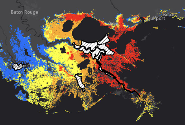
This is incredibly dangerous storm surge. The worst surge will be from Burns Point, LA to the Mississippi/Alabama border, where 6-15 feet of surge is expected. This includes Lakes Pontchartrain and Maurepas, where 4-8 feet of surge is likely.
In the map below, all areas shaded orange or red will have surge greater than 6-9 feet above ground.
White hashed areas are protected by levees. This includes Metro New Orleans, but surge greater than 9 feet above ground will occur all around the city. 9+ foot surge will also be found along parts of the Mississippi Delta, the north shore of Lakes Pontchartrain & Maurepas, and the coast from the Delta to around Gulfport, MS.
Extreme wind & devastating storm surge will not be the only impacts from Hurricane Ida. Very heavy rainfall will extend well inland. The graphic below shows expected total rain from Ida.
Areas shaded in red and magenta will receive a whopping 10-20 inches of rain, including New Orleans & Baton Rouge. Freshwater flooding & flash flooding is likely.
Overall, Hurricane Ida is a very dangerous situation for the Central Gulf Coast. Stay tuned to the National Hurricane Center for the latest updates on the storm, and keep those in Ida’s path in your thoughts & prayers.


No comments:
Post a Comment