Sunday, December 31, 2023

Routine Start to 2024, Extended Forecast Preview

FastCast—Monday, Jan. 1 to Thursday, Jan. 4:

A calm New Year’s is expected for the Pacific Northwest, with mostly cloudy conditions and no rain. Lowland temperatures for midnight festivities will be in the upper 30s to low 40s, with calm winds. On New Year’s Day, expect mostly cloudy conditions, with highs in the mid 40s and lows in the low 30s. Tuesday will bring a weather system, with 0.2-0.5” of rain in the lowlands, and up to 6” of snow at the passes. Wednesday and Thursday will be mostly cloudy, with another system slated to impact the area from late Thursday through Friday. From Tuesday to Thursday, expect lowland highs in the mid to upper 40s, with lows in the upper 30s to low 40s.

————————————————————

Author’s Note:

I want to thank all of the readers of my blog for following along this year! It was a good year, and I enjoy writing blogs for you all. Happy New Year!

-Matthew

————————————————————

Continue reading the full blog below!

A cool…but not cold…New Year’s is expected for the Pacific Northwest. Let’s start below with the European model forecast for temperatures at midnight.


At midnight, expect temperatures in the upper 30s in Seattle, mid to upper 30s in Portland, and low 30s in Spokane. Mountain towns will be in the mid to upper 20s.

2024 will start calm across the region, but a system is ahead on Tuesday. Below is the European model forecast for total rain through Wednesday.


Expect 0.2-0.4” for the lowlands and 0.4-0.6” for the coast. Areas near the Cascades in Eastern WA could get 0.1-0.3”. 

This system will bring a round of snow to the Cascades, which is much-needed. Below is the European model snow forecast through Wednesday.


This forecast shows Snoqualmie, Stevens, and White Passes receiving 4-6” of snow, which could bring brief travel impacts (mainly on Tuesday), so drive prepared!

Finally, we’ll look at the extended temperature forecast for Seattle from the European EPS model, seen below.


The reason we are looking at this forecast is the second half of it (January 6-15). Some extended forecasts are hinting at a shift toward colder weather sometime in early to mid January. In this forecast, notice how the range of temperatures (gray and blue vertical lines) show a huge range of possible highs and lows. Toward the end of this forecast, highs range from 15º-50º, with lows ranging from 5º to 45º. Essentially, there is huge uncertainty, but some potential for a colder pattern.

A cold pattern would be great news for the Cascades, where snowpack is far below normal. Below is the Washington snowpack map from the USDA/NRCS.


Notice that the entire state has 25-70% of average snowpack, much below normal. A potential cold pattern would help our struggling snowpack. Stay tuned!

Tuesday, December 26, 2023

Strong Gap Winds & High Surf Due to Storms Offshore

 FastCast--Wednesday, Dec. 27 to Saturday, Dec. 30:

Due to storms offshore, the Northwest will be impacted by strong winds in the foothills and near gaps in the terrain, while the same offshore storm brings high surf to the coast. Overnight Tuesday into Wednesday morning, expect wind gusts near the gaps to reach 40-45 mph, with some isolated gusts up to 55 mph. These winds will cause areas of tree damage and power outages. On the coast, waves will reach 20-25 feet, bringing dangerous surf, large breaking waves, and potential coastal flooding and beach erosion. Easterly offshore flow will bring warm temperatures to the lowlands. Highs on Wednesday will reach the low 50s, but will warm significantly to the mid to upper 50s on Thursday and Friday. Temperatures will begin to decrease on Saturday, with highs back in the low 50s. Low temperatures will remain in the low to mid 40s. Additionally, expect 0.2-0.5" of rain across the lowlands through Thursday morning.

--------------------------------------------------------

Continue reading the full blog below!

Two different weather hazards are impacting the region...gap winds and high surf. Let's take a look at the forecast!

We'll start with the European model forecast for sea level pressure early Wednesday morning.


Notice the difference in pressure across the Cascades, with low pressure offshore. The cross-Cascade pressure difference is what fuels gap winds, and the deep low pressure offshore is what causes the large swells and high surf. 

Now, let's take a look at the wind forecast, starting with the European model.


This forecast shows gap winds (E-SE winds) gusting 40-50 mph, strongest along the foothills from Eatonville to US-2. The lowlands, mainly from Auburn to Seattle, could gust 20-35 mph. The coast will also be breezy, with SE winds gusting 30-40 mph.

Let's compare this to the HRRR high-resolution forecast, also showing peak gusts through Wednesday.


This forecast shows winds in the foothills gusting 30-40 mph, weaker than the European model. The lowlands gust 25-35 mph, except 35-45 mph for Whidbey Island, Whatcom County, and the San Juans. The coast gusts up to 45-50 mph in this forecast. 

Now, let's switch gears to looking at the forecast for wave heights. Below is the European model forecast for wave heights on Thursday morning.


The European model shows 20-25 foot waves reaching the Washington and Oregon coasts from late Wednesday night through Thursday. 

Let's compare this to the GFS forecast, seen below, also showing waves on Thursday.


The GFS forecast shows similar waves of 22-28 feet reaching the Northwest coast from late Wednesday to Thursday. 

There is good agreement on this forecast, so expect high surf, waves running far up beaches, potential coastal erosion and flooding, and be very aware on jetties and around logs. 

Next, here is a look at total rain through Thursday morning, from the European model.


Expect 0.1-0.4" in the lowlands (isolated higher amounts), with 0.5-1.5" on the coast and Kitsap Peninsula. Most rain will fall by Thursday morning.

Finally, a look at high temperatures on Friday (Thursday will be similar), from the European model.


Due to warming offshore flow, expect lowland highs to reach the mid to upper 50s, with some areas reaching the low 60s. The coast will reach the low to mid 50s. Areas from Skagit County northward will be sheltered from the offshore flow, keeping high temperatures in the upper 40s to low 50s.

Stay safe in areas impacted by gap winds and high surf, and enjoy our interesting weather!

Sunday, December 24, 2023

Active Christmas Ahead for the Northwest

FastCast—Monday, Dec. 25 to Wednesday, Dec. 27:

An active Christmas is expected across the Northwest as a storm impacts the region. In the lowlands, expect rain and wind, with snow and freezing rain potential in the mountains. The lowlands will receive 0.4-0.8” of rain, with isolated higher amounts possible. Winds will be strongest from Everett northward and on the coast, with peak gusts from Christmas night to early Tuesday. The lowlands will likely gust 25-35 mph, with Island County, the San Juans and the eastern Strait/Admiralty Inlet gusting 40-50 mph. The coast will gust 45-55 mph. In the mountains, the passes will receive 2-4” of snow, with a potential for 0.1-0.2” of impactful freezing rain, mainly on Christmas. Expect lowland highs in the mid 40s on Christmas, increasing to the upper 40s to low 50s on Tuesday and Wednesday. Christmas morning lows will be in the mid 30s, increasing to the mid 40s on Tuesday and Wednesday mornings. 

————————————————————

Continue reading the full blog below!

A wet and windy Christmas is expected for the lowlands, with winter weather hazards possible for the mountains and Eastern Washington. Let’s take a look at the forecast!

We’ll start with the wind forecast. Below is the HRRR high-resolution forecast for peak winds through Tuesday morning.


This forecast shows gusts of 30-40 mph in the lowlands, with 40-55 mph gusts from Everett northward, strongest in the San Juan Islands and Western Whatcom County (gusts 50-55 mph). This forecast also shows 55-60 mph gusts along the immediate shoreline of the WA coast. Peak winds would likely be from evening on Christmas to Tuesday morning.

Let’s compare this to the European model forecast, shown below (in knots).


This forecast backs off the wind speeds somewhat, showing 25-35 mph gusts in the lowlands, with 50-55 mph gusts on the coast, and 35-40 mph from Everett northward, except 45-55 mph for Whidbey Island, the San Juans, and W. Whatcom County. Peak winds would be from late Christmas to Tuesday morning.

Finally, let’s take a look at the NAM high-resolution forecast, which shows far stronger winds than either of the forecasts we’ve seen so far. This first image is for gusts at 10 PM Christmas night.


This forecast shows gusts late on Christmas reaching 25-40 mph for most of the lowlands, 50-55 mph on the coast, and 45-55 mph for Whidbey Island, Whatcom County, and the San Juan Islands (where 55+ mph gusts are possible).

Next, let’s take a look at the NAM forecast, a few hours later around 12 AM Tuesday.


This shows far stronger winds for the lowlands than any other forecast, showing gusts of 40-50 mph from Olympia all the way to Bellingham. This is quite unlikely, but is still a slight possibility.

Now, let’s switch gears and talk about precipitation. Below is an informative graphic from NWS Spokane regarding winter precipitation.


Most of Eastern Washington will get very light snow, with a 4-6” possible at the passes (more at Stevens Pass). The main impact is the potential for freezing rain across the Columbia Basin. If any freezing rain falls, it will be brief, and would accumulate to around 0.1” at most. The passes and Columbia River Gorge have a potential for up to 0.2” of freezing rain, so be prepared not only for snow but for ice if you are traveling.

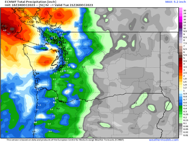
Back on the west side, below is the European model forecast for rain through midday Tuesday.


This forecast shows 0.3-0.5” for the lowlands and 0.7-1.4” for the coast, with the brunt of the rain hitting British Columbia (1.5-5” depending on location).

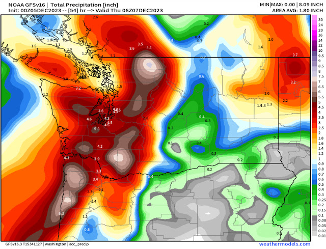
Let’s compare this to the GFS (American) model forecast for rain through midday Tuesday, seen below.


This forecast shows more rain area-wide, with 0.7-1.3” in the lowlands, a clear NE Olympic rain shadow, and 1-2” for the coast. Plus, Eastern WA gets widespread light precipitation (this would fall as a trace to 2” of light snow in this forecast).

Overall, an active Christmas is ahead, with rain and wind in Western WA, and multiple winter weather hazards in Eastern WA. These impacts will continue into Tuesday morning. Remember to be prepared and travel safe! Merry Christmas to all who celebrate!

Wednesday, December 20, 2023

Foggy & Calm, Next System on Friday Bringing Rain and Mountain Snow

 FastCast—Thursday, Dec. 21 to Sunday, Dec. 24:

Another calm and foggy day is expected across the lowlands on Thursday, with a Dense Fog Advisory in effect for most of the region until 12 PM. Visibility could be as low as 1/4 mile, so be cautious. The next system approaches the area on Friday, bringing a brief round of rain (likely 0.2-0.5” for the lowlands) and winds gusting 25-30 mph. The passes will pick up 4-6” of snow, which could bring brief impacts for Christmas travel. Expect highs in the mid to upper 40s on Thursday, then in the low to mid 40s from Friday to Sunday. Lows will be in the low to mid 40s on Thursday and Friday, then in the upper 20s to low 30s on Saturday and Sunday mornings. The next system will arrive by late Saturday, bringing rainy conditions on Christmas Day. Stay tuned!

————————————————————

Continue reading the full blog below!

More fog and calm weather is expected across the region on Thursday. NWS Seattle has issued a Dense Fog Advisory through 12 PM Thursday for most of the region. Below is the European model forecast for visibility on Thursday morning.


This forecast shows visibility of 0.1-0.5 miles for most of the lowlands from Seattle southward on Thursday morning. Fog is hard to forecast, so low and potentially hazardous visibility may be more widespread than this forecast shows.

A good marker for where fog is most likely is the extent of the Dense Fog Advisory, seen below on this map.


Basically, the advisory covers the entirety of the lowland regions from Chehalis northward to the San Juan Islands. 

Now, let’s take a look at the next system, moving into the area on Friday. Below is the European model forecast for total rain through Saturday.


This forecast shows 0.2-0.5” for the lowlands, with less from Seattle south (as little as 0.1”). Areas from Everett to Bellingham could get up to 0.5-0.75”. The coast will likely pick up 0.6-0.8” with this system.

Let’s compare this to the GFS forecast, also showing rain through Saturday.


This forecast shows less rain overall, with most of the lowlands getting 0.05-0.2” and being in a rain shadow (mainly from Olympia to Seattle), with areas from Seattle north getting 0.2-0.5”. The coast gets 0.4-0.8” in this forecast.

Finally, let’s take a look at the mountain snow forecast. That’s the only part of this system that could have an actual impact. Below is the European model forecast for snow through Saturday.


This forecast shows the passes getting 4-6” of snow, with up to 8” at Stevens Pass. Most will fall on Friday. This could cause brief travel impacts, especially with increased holiday traffic. Areas south of Snoqualmie Pass will only receive 3-4” of snow.

Let’s compare this with the GFS forecast, also showing snow through Saturday.


This forecast shows 4-8” of snow for Snoqualmie Pass and up to 12” for Stevens Pass, with areas south of Snoqualmie Pass receiving up to 4”. 

There is potential for brief heavier snow at Stevens Pass on Friday and early Saturday due to Convergence Zone bands in the area. Overall, there is a potential for snow-related impacts, but the brief duration of this system will mitigate a major event.

Stay tuned for updates as somewhat more active weather is possible around Christmas and beyond!

Saturday, December 16, 2023

Calm Weekend, Early Week Rain

FastCast--Sunday, Dec. 17 to Wednesday, Dec. 20:

After a calm and relatively uneventful week, similar conditions are expected this weekend. On Sunday morning, expect lows reaching the low to mid 30s across the lowlands, with partly sunny conditions and highs in the mid to upper 40s. Monday will be cloudy with evening showers. That rain will continue into Tuesday, tapering off by afternoon. The lowlands will receive 0.4-0.6" of rain, with isolated higher amounts. On Monday, expect highs in the mid 40s, increasing to the low 50s by Tuesday and Wednesday. Expect Wednesday to be partly cloudy, with highs in the low 50s. Lows through midweek will reach the upper 30s to low 40s. 

Air quality will be stagnant at times over the next few days. Check air quality below:

Washington State Air Quality Map (PurpleAir)

---------------------------------------------------------------------

Continue reading the full blog below!

Calm weather will continue for the next few days across Washington, with a weak system bringing a round of rain from Monday to Tuesday. Let's take a look at the forecast!

On Sunday morning, lows across the state will be on the chilly side. Below is the European model forecast.


In the lowlands, expect lows in the low 30s, with some areas staying in the mid 30s. The coast will only drop to the upper 30s to low 40s, with the Willamette Valley dropping to the low to mid 30s. Eastern Washington will be much colder, dropping to the low 20s near Spokane and the mid to upper 20s elsewhere.

Now, let's take a look at the upcoming system. Below is the European model forecast for rain through early Wednesday.


This forecast shows the lowlands getting 0.5-0.7", with isolated areas getting up to 1". The coast and Willamette Valley will get 0.4-0.9", and Eastern Washington will get 0.1-0.3". 

Let's compare this to the GFS forecast, seen below.


This forecast shows 0.4-0.5" for the lowlands, with the coast getting 0.5-0.7", and Eastern Washington getting 0-0.2". 

Now, let's take a look at the snow forecast from the European model, through early Wednesday.


Snow won't be too impressive, with 0.5-2" at the passes (most at Stevens Pass). Most snow (4-6") will fall in the North Cascades backcountry. 

Now, let's take a look at the extended forecasts from the NWS Climate Prediction Center (CPC) for December 24-30. 

Below is the temperature outlook.


This is a classic El Niño pattern for winter, showing significantly above average temperatures for the entirety of the Lower 48, especially in the High Plains and Upper Midwest. The Northwest will have a 50-60% probability of above average temperatures through Christmas and New Year's.

Let's round out the blog by looking at the precipitation outlook, seen below.


Again, in a classic El Niño pattern, the northern tier of the US (with the exception of Washington) will likely have below average precipitation, with California and the southern tier of the country getting above average precipitation. In Western Washington, there is a 40-50% probability of above average precipitation, with a 30-40% probability of above average precipitation for Eastern Washington.

Enjoy the calm and non-impactful weather as holiday travel ramps up!

Saturday, December 9, 2023

Next Atmospheric River Ahead

 FastCast—Saturday, Dec. 9 to Tuesday, Dec. 12:

The next atmospheric river is ahead for the Pacific Northwest, bringing another round of rain, heavy at times, and heightening the landslide risk. Rivers will rise again, but likely not reaching flood stage, except the Skokomish River in Mason County, which will reach minor flood stage. The Snoqualmie River may reach bankfull through the valley. For the lowlands, expect 1-1.5” of rain from Saturday to Sunday evening. Temperatures will drop to the low to mid 30s by Saturday morning, only rising to the mid 40s on Saturday. This presents an interesting possibility of BRIEF snowflakes across the lowlands as precipitation begins on Saturday morning. The best chance of seeing brief snow is on the Kitsap Peninsula, on higher hills, and in scattered areas from Everett northward. Additionally, expect winds gusting 45-55 mph from Everett northward on Saturday, potentially up to 60 mph for the San Juans. Temperatures will continue rising overnight and into Sunday morning, with highs on Sunday reaching the low 50s across the lowlands. Rain will end across the lowlands by Sunday evening. Monday and Tuesday will be partly cloudy with highs in the mid 40s and lows in the mid 30s. In the mountains, expect 8-12” at the passes of snow on Saturday, before snow levels increase to 5,000-6,000 feet by Sunday morning. Note that there is a chance of freezing rain at Snoqualmie and Stevens Passes on Sunday, before a transition to rain. This could bring additional travel impacts to the passes, so stay aware.

———————————————————

Continue reading the full blog below!

The next atmospheric river is ahead for the Pacific Northwest, with rain and mountain snow ahead, before mountain snow changes to rain. Additionally, we’ll take a look at the slight chance of BRIEF snowflakes in the lowlands on Saturday. Let’s take a look at the forecast!

Below is the European model forecast showing the atmospheric river aimed at the Northwest on Saturday evening.


Notice the tongue of moisture (significantly weaker than last time), aimed at the Northwest. This is what will bring the next round of rain to the region over the weekend.

As rain begins across the region on Saturday morning to midday, colder air from a chilly night will still be in place, with temperatures across the lowlands likely in the mid 30s. Once heavier rain starts falling, this can lead to adiabatic cooling, where the process of heavier precipitation falling saturates the atmosphere and cools the air enough for snowflakes to mix in with the rain. This can typically happen when the temperature is 34º or cooler in Western Washington. 

Below is the HRRR high-resolution forecast showing what the weather radar could look like midday Saturday.


Notice how this forecast shows snow (blue) across the foothills, parts of the lowlands, and the Kitsap Peninsula, and look around the areas of potential snow…around snow is heavy rain, showing that snow will only fall due to heavy rain moving in. 

This is a “low confidence” scenario, but some snowflakes are possible. Brief snow accumulations aren’t likely, but if that does happen it would likely be relegated to the higher hills of the Kitsap Peninsula. Snow is also possible across the Vancouver BC metro area, due to colder air moving out of the Fraser River Valley. Again, any snowflakes will be brief, as the atmospheric river will overwhelm the snow and bring a quick return to rain.

Let’s take a look at the snow forecast for the state, seen below on the European model.


The European model does show light snow for the Kitsap Peninsula and a potential to see some brief snow from Everett northward. This forecast shows 8-16” in the passes and 4-6” from I-90 northward in Eastern Washington, with a potential for 5-6” around Spokane. All snow will fall by midday Sunday for the Cascades and Eastern WA.

Let’s compare this to the NAM high-resolution forecast for snow in Western WA, seen below.


The NAM forecast shows accumulating snow on the Kitsap Peninsula, in the foothills, and in some areas from Everett northward. This is likely overdone, and most areas that have accumulating snow in the forecast will likely see brief snowflakes (maybe heavy snow, but not sticking). This forecast gives the passes 6-10” of snow, so prepare for travel impacts on Saturday into Sunday morning.

Finally, before we shift to the rain forecast, below is the UW WRF high-resolution snow forecast.


This forecast is similar to the NAM, showing light snow potential around the lowlands, especially Everett northward, with accumulating snow on the Kitsap Peninsula. Again, this is likely overdone. The passes receive 8-16” in this forecast.

Now, let’s take a look at rain. Below is the European model forecast for total rain through Monday morning.


The European model forecast shows the lowlands being somewhat rainshadowed, getting 0.8-1.2”, with the NW Interior getting 1-1.2”, areas from Olympia south and west getting 1.2-1.5”, and the coast getting 2-3”. The Willamette Valley gets similar amounts as the lowlands (1-1.3”) in this forecast. Eastern Washington may pick up 0.2-0.6” as well.

Let’s compare this to the GFS (American) model, seen below, also showing total rain through Wednesday.


The GFS shows a much wetter solution for areas from Everett south. From Everett north, this forecast shows 0.8-1”. For Everett south, this forecast shows 1.5-2”, with the Willamette Valley getting 2-2.5” in this forecast, and the coast getting 1.5-3.5”. This forecast shows higher totals for Eastern Washington as well, especially from Spokane southward.

Finally, strong SE winds are expected for the North Sound, Northwest Interior, and the San Juans on Saturday. Below is the HRRR high-resolution forecast showing expected peak winds.


The HRRR forecast shows winds gusting 40-50 mph from Everett northward, with gusts of 50-60 mph for the San Juan Islands, and 40-50 mph on the coast, except potentially up to 55-60 mph along the Western Strait (near Neah Bay) and Cape Flattery.

Stay safe out there (especially in the mountains) and be prepared for standing water, low visibility, and heavy rain.

Wednesday, December 6, 2023

More Rain and Mountain Snow Ahead, Weekend Atmospheric River Likely

FastCast—Thursday, Dec. 7 to Sunday, Dec. 10:

As the major atmospheric river that brought significant impacts finally moves out of the region, there will only be a brief reprieve before the next atmospheric river (faster & weaker) arrives in the Northwest, likely from Saturday to Sunday. Rivers are currently receding from flooding due to the major atmospheric river, with all rivers likely to fall below flood stage by Thursday evening. On Thursday, expect cloudy skies, highs in the mid 40s, and 0.3-0.8” of rain as another system moves through. Lows on Friday morning will drop to the mid 30s. Friday looks to be the only dry day of the week, with partly cloudy skies and highs in the mid 40s. Lows by Saturday morning will likely drop to the low to mid 30s. Temperatures will rise to the low to mid 40s by the end of the day Saturday, with rain beginning in the morning, continuing through Sunday afternoon. The lowlands will likely receive 1-2” of rain with this next atmospheric river, but that forecast is still being determined. Snow levels will remain around 2,000 feet from Friday to Saturday night, bringing 8-16” of snow to the passes, before snow levels rise above to passes to 4,500 feet on Sunday, bringing rain to the passes and likely melting snow. At this point, it is unlikely that rivers will rise back to flood stage, but that remains to be monitored.

Find atmospheric river rain totals at the bottom of this blog!

—————————————————————

Continue reading the full blog below!

As the major atmospheric river moves out of the region, more rain is on its heels, with a system on Thursday followed by an atmospheric river over the weekend. 

Below is the European model forecast showing total rain through Friday morning.


This forecast shows 0.4-1” for the lowlands through Friday, 0.7-1.2” for the coast, and 0.8-1” from Everett northward. Most of Eastern Washington will pick up 0.3-0.5” in this forecast.

Next, let’s take a look at the GFS model forecast, also through Friday morning.


The GFS model agrees with the European, showing 0.5-1” for the lowlands and the coast, with less in Eastern Washington (0.2-0.3”).

The NAM high-resolution forecast, showing rain through Friday morning, is below.


This forecast, zoomed in on Western Washington, shows 0.4-0.8” for the lowlands, and 0.5-1” for the coast. Isolated areas of the lowlands (mainly near the foothills) could get over 1” in this forecast.

Now, let’s transition to mountain snow. Snow levels will be between 2,000 and 3,000 feet on Thursday and Friday, bringing a return of snow to the passes. Below is the European model forecast for snow through Friday morning.


The European model shows 5-10” of snow at the passes through Friday morning, which could bring travel impacts, so be aware of the forecast if you are traveling over the passes. The highest totals will be at Stevens and White Passes due to their elevations.

Finally, we’ll wrap up this portion of the blog by taking a look at the atmospheric river slated to arrive this weekend. Below is the European model forecast showing the atmospheric river.


This forecast, showing precipitable water (a measure of the amount of water in the atmosphere) on Saturday evening, clearly shows the atmospheric river aimed at the region. The lowlands will likely pick up another 1-2” of rain with this atmospheric river, with more likely on the coast. Stay tuned!

———————————————————

12/4-6 Atmospheric River Rainfall Totals:

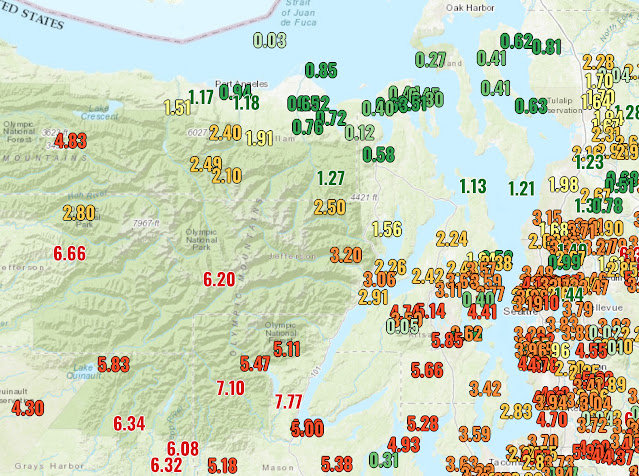
Below are graphics showing rainfall totals across Western Washington due to the recent major atmospheric river. Most of the lowlands received 2.5-4.5” of rain, with the Kitsap Peninsula getting 5-6”, and the mountains getting 6-10”. 

Of note is the incredible Olympic rain shadow, with 0.1-0.3” total at Port Townsend and along Whidbey Island, versus 6-8” on the southern slopes of the Olympics, under 50 miles away! Additionally, I marked the Stillaguamish River, where an all-time flood record was set and major impacts occurred in Granite Falls, Arlington, and Silvana. The headwaters of the Stillaguamish received up to 10” of rain. 

The final image shows a zoomed-in view of rain totals for areas from Tacoma to Seattle.


Monday, December 4, 2023

Monday Night Atmospheric River Update

No FastCast tonight…continue reading the full blog below for an update on the rain and flooding forecast for the atmospheric river.

A significant atmospheric river is impacting the Pacific Northwest, with heavy rain, river flooding, and urban flooding expected. Rain will be steady (heavy at times) on Tuesday, slowly tapering off through the day Wednesday. Let’s take a look at the forecasts.

Additionally, subtropical moisture related to this atmospheric river will bring warm temperatures to the region (the lowlands reached the upper 50s to low 60s on Monday), with the mid to upper 50s continuing on Tuesday.

Let’s start with the European model’s forecast for total rain through Wednesday evening.


This forecast shows 2-3” for the lowlands, with less in the rain shadow NE of the Olympics (1-1.5”). The coast gets 2.5-4”, with the Willamette Valley getting 3-4”, and Eastern WA getting 1-2.5”. The Cascades and Olympics will get 5-8”.

Let’s compare this to the GFS (American) model, also showing total rain through Wednesday evening.


This forecast is much wetter, showing 4-5” for the lowlands, except less in the rain shadow (1-1.5”), which is poorly defined in this forecast. The coast and Willamette Valley get 1.5-3”, along with parts of Eastern WA. The mountains across the region get 5-7” in this forecast.

Now, we will look at high-resolution forecasts, focused specifically on Western Washington. First, let’s take a look at the NAM high-resolution forecast through Wednesday evening.


The NAM forecast shows 3-3.5” for the lowlands, with isolated areas getting up to 4”. A very pronounced rain shadow is seen from Everett northward and westward (0.25-1.5”). The mountains could get up to 10” of rain in this forecast.

Next, the UW WRF forecast for Western Washington, showing rain through Wednesday evening.


This forecast is very similar to the NAM, showing over 3” of rain from Seattle southward, with 1.5-2.5” from Seattle north, excluding the rain shadow area (0.3-1.25”). The mountains will get 3-10” in this forecast.

The last forecast we’ll look at is the HRRR high-resolution forecast, which doesn’t go as far, only to Wednesday afternoon, seen below.


The HRRR forecast shows 2.5-3” for the lowlands, 3-4” for the foothills, and a relatively large rain shadow NE of the Olympics (0.7-1.5”). The mountains get up to 10” in this forecast as well.

Now, let’s take a look at the NWS Weather Prediction Center (WPC) Excessive Rainfall Outlook for Tuesday (Dec. 5).


This shows a Moderate risk (40% chance) of flash flood conditions on the Olympic Peninsula, with a Slight risk (15% chance) for the coast, Cascades, and lowlands from Seattle southward. A Marginal risk (5% chance) exists from Seattle northward in the lowlands.

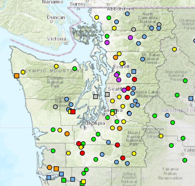
Finally, let’s take a look at river flooding potential, shown below from the NWS Advanced Hydrologic Prediction Service forecast.


Yellow is bankfull stage, which many rivers will reach, including the Nooksack, White, Cedar, Puyallup, Willapa, and Issaquah Creek. Orange is minor flood stage, which the Carbon, Stillaguamish, and Bogachiel will reach. Red is moderate flood stage, which the Skykomish, Chehalis, Neuwakum, Cowlitz, Nisqually, and Skokomish, will reach. Magenta is major flood stage, which the Snoqualmie/Snohomish and Skagit Rivers are expected to reach.

Remember that in addition to river flooding, these large amounts of rain within a short timeframe will bring urban flooding, water over roadways, and flooding in creeks and small streams. Remember to “turn around, don’t drown” and to not drive through flooded roadways. Stay tuned for further updates!

Brief Spring Atmospheric River Bringing a Wet Weekend

  FastCast--Saturday, May 4 to Thursday, May 9: A fast-moving atmospheric river will bring a wet weekend to the Pacific Northwest. With the ...