FastCast—Monday, Dec. 25 to Wednesday, Dec. 27:
An active Christmas is expected across the Northwest as a storm impacts the region. In the lowlands, expect rain and wind, with snow and freezing rain potential in the mountains. The lowlands will receive 0.4-0.8” of rain, with isolated higher amounts possible. Winds will be strongest from Everett northward and on the coast, with peak gusts from Christmas night to early Tuesday. The lowlands will likely gust 25-35 mph, with Island County, the San Juans and the eastern Strait/Admiralty Inlet gusting 40-50 mph. The coast will gust 45-55 mph. In the mountains, the passes will receive 2-4” of snow, with a potential for 0.1-0.2” of impactful freezing rain, mainly on Christmas. Expect lowland highs in the mid 40s on Christmas, increasing to the upper 40s to low 50s on Tuesday and Wednesday. Christmas morning lows will be in the mid 30s, increasing to the mid 40s on Tuesday and Wednesday mornings.
————————————————————
Continue reading the full blog below!
A wet and windy Christmas is expected for the lowlands, with winter weather hazards possible for the mountains and Eastern Washington. Let’s take a look at the forecast!
We’ll start with the wind forecast. Below is the HRRR high-resolution forecast for peak winds through Tuesday morning.
This forecast shows gusts of 30-40 mph in the lowlands, with 40-55 mph gusts from Everett northward, strongest in the San Juan Islands and Western Whatcom County (gusts 50-55 mph). This forecast also shows 55-60 mph gusts along the immediate shoreline of the WA coast. Peak winds would likely be from evening on Christmas to Tuesday morning.
Let’s compare this to the European model forecast, shown below (in knots).
This forecast backs off the wind speeds somewhat, showing 25-35 mph gusts in the lowlands, with 50-55 mph gusts on the coast, and 35-40 mph from Everett northward, except 45-55 mph for Whidbey Island, the San Juans, and W. Whatcom County. Peak winds would be from late Christmas to Tuesday morning.
Finally, let’s take a look at the NAM high-resolution forecast, which shows far stronger winds than either of the forecasts we’ve seen so far. This first image is for gusts at 10 PM Christmas night.
This forecast shows gusts late on Christmas reaching 25-40 mph for most of the lowlands, 50-55 mph on the coast, and 45-55 mph for Whidbey Island, Whatcom County, and the San Juan Islands (where 55+ mph gusts are possible).
Next, let’s take a look at the NAM forecast, a few hours later around 12 AM Tuesday.
This shows far stronger winds for the lowlands than any other forecast, showing gusts of 40-50 mph from Olympia all the way to Bellingham. This is quite unlikely, but is still a slight possibility.
Now, let’s switch gears and talk about precipitation. Below is an informative graphic from NWS Spokane regarding winter precipitation.
Most of Eastern Washington will get very light snow, with a 4-6” possible at the passes (more at Stevens Pass). The main impact is the potential for freezing rain across the Columbia Basin. If any freezing rain falls, it will be brief, and would accumulate to around 0.1” at most. The passes and Columbia River Gorge have a potential for up to 0.2” of freezing rain, so be prepared not only for snow but for ice if you are traveling.
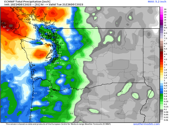
Back on the west side, below is the European model forecast for rain through midday Tuesday.
This forecast shows 0.3-0.5” for the lowlands and 0.7-1.4” for the coast, with the brunt of the rain hitting British Columbia (1.5-5” depending on location).
Let’s compare this to the GFS (American) model forecast for rain through midday Tuesday, seen below.
This forecast shows more rain area-wide, with 0.7-1.3” in the lowlands, a clear NE Olympic rain shadow, and 1-2” for the coast. Plus, Eastern WA gets widespread light precipitation (this would fall as a trace to 2” of light snow in this forecast).
Overall, an active Christmas is ahead, with rain and wind in Western WA, and multiple winter weather hazards in Eastern WA. These impacts will continue into Tuesday morning. Remember to be prepared and travel safe! Merry Christmas to all who celebrate!


No comments:
Post a Comment