Thursday, April 29, 2021

Rain Returns for Friday, Showery Saturday

Thursday was a warm day, with highs around the area reaching the mid-70s.


Winds shifted and picked up in the afternoon as marine air and clouds made their way into the lowlands.

Rain is expected by Friday morning. The UW forecast model is below, showing 0.3 to 0.5 inches of rain by 5 AM Sunday.


Expect rain to end by late Saturday. Most rain will fall on Friday.

The Weather Underground forecast for Puyallup is below.


Highs will remain in the upper 50s to mid 60s through the next few days. This is near our seasonal normal. Expect mostly dry days on Saturday (especially afternoon), Sunday, and Tuesday. 

Announcement: Starting this weekend, I will be doing a 3-post series about the major drought in the Western United States. Stay tuned!


Tuesday, April 27, 2021

More Clouds & Rising Temperatures

The past couple days have been mostly cloudy, with seasonable temperatures in the upper 50s to low 60s. 

This trend is forecast to continue through the week, with temperatures rising to the upper 60s on Wednesday and mid to upper 70s on Thursday. I expect rain showers to return by late Thursday night/Friday morning.

Below is the Puyallup forecast from Weather Underground.


The big thing to notice is the warm temperatures on Wednesday and Thursday. We’re no stranger to those warmer temperatures after our previous dry spell. Rain will return by late Thursday night or by Friday at the latest.

This is a short post...but soon, we will examine the major, devastating drought that is impacting most of the Western United States.

Stay tuned & enjoy the warmer temperatures!


Sunday, April 25, 2021

Most Rain In A Month & A Cloudy Week Ahead

This past weekend gave us much-needed rain, the most rain since late March. The weekend rain totals are below.


Most of the area received 0.25 to 0.8 inches of rain. 

The previous dry spell was enough to place Western Washington in the “abnormally dry” category of the US Drought Monitor. Below is the drought monitor, categories in the bottom right.


Thankfully, Western Washington’s drought is only slight and short term compared to the major, exceptional drought occurring across most of the western and southwest United States.

The week ahead is going to be mostly cloudy and dry, before rain returns later on Friday. Puyallup’s forecast from Weather Underground is below.


Notice temperatures to likely be above 60 degrees each day, peaking with a warm and possibly muggy day on Thursday, when temperatures in the mid to upper 70s are likely.

The weekend’s rain freshened up the atmosphere after our long dry spell...and now we return to somewhat “normal” spring weather.


Thursday, April 22, 2021

Return of Clouds and Rain

We have had a record-breaking stretch of April weather, with the warmest 7 day stretch in Seattle history for April. Multiple records were broken and we went over 5 days with no clouds in sight.

However, change is upon us. Thursday was the coolest day in over a week and the cloudiest in nearly 2 weeks, a summer-like gap between cloudy days. Rain makes its return this weekend as well, ending the longest dry spell since September 2020.

This weather pattern change is due to the breakdown of the massive and persistent high pressure ridge that brought our spring heat wave. Two maps from the UW forecast model are below. The top one is for last Saturday (peak of the heat) and the bottom one is for 8 AM Saturday.


The high pressure ridge is completely gone, replaced by a low pressure trough that will bring clouds and rain.

Below is the Puyallup forecast from Weather Underground.


Rain is likely to return late Friday night through Saturday. Temperatures reach the low-mid 60s with the exception of Saturday, where highs struggle to reach the low 50s. The highest chance of rain is on Saturday, with a dry day Sunday and chances of showers to start next week.

The UW forecast below shows expected rain through 5 AM Sunday.


Expect 0.3 to 0.75 inches of rain from Friday night to late Saturday. This will be our first rain in nearly 2 weeks, so be prepared for some slick spots on the roads. Higher rain totals are expected near the coast, in the foothills, and north of Everett.

A return to more traditional spring weather is in the forecast. The rain should be refreshing to the atmosphere after our record-breaking heat & sun!


Tuesday, April 20, 2021

Abnormally Dry Conditions Prompt Over 90 Wildfires In Washington State

Tuesday marked the 6th consecutive day above 70 degrees at SeaTac Airport. That is the longest such streak in the month of April in over 125 years of record keeping in Seattle. 

This record dry streak has prompted above normal fire danger across Washington State, with the Department of Natural Resources responding to over 90 wildfires in a week (ending Monday). Most of these fires have burned under 100 acres, but it is significant that so many fires are burning in April in the first place.


The Department of Natural Resources (DNR) has issued
burn restrictions effective until rain dries out vulnerable grasses. These restrictions are available below:

https://burnportal.dnr.wa.gov/

Below is a map from MyRadar Weather that shows an approximate number of fires that are currently burning around the state.


As you can see, northeast Washington has been hit particularly hard, with many small wildfires popping up, mainly due to strong winds and very dry conditions. 

Western Washington has been impacted by these fires as well. Several small wildfires have occurred around the area, with some forcing the use of helicopter water drops and evacuations being issued.

Fires were reported in Eatonville, Lacey, Auburn, and even on the coast in Pacific County.


This brush fire burned about 10 acres on Friday just north of Eatonville.


The Green Valley Fire sparked due to an out of control burn pile on Sunday evening and has burned about 50 acres and is 75% contained as of Tuesday evening. The fire's spread was aided by winds and low humidity. Level 1 evacuations are in effect (briefly level 2 on Monday). Helicopter water drops were required on Sunday evening. The fire is difficult to contain due to the terrain of the area. The fire is located around 17100 SE Green Valley Road.

Updated information about the Green Valley Fire here: https://thenwfireblog.com/2021/04/20/day-3-green-valley-fire-continues/

Fires were even reported on the coast in Pacific County:


So...what role did weather play in these and other fires around Washington State? 

We will specifically be focusing on conditions in Western Washington, but similar conditions brought fire danger in Eastern WA.

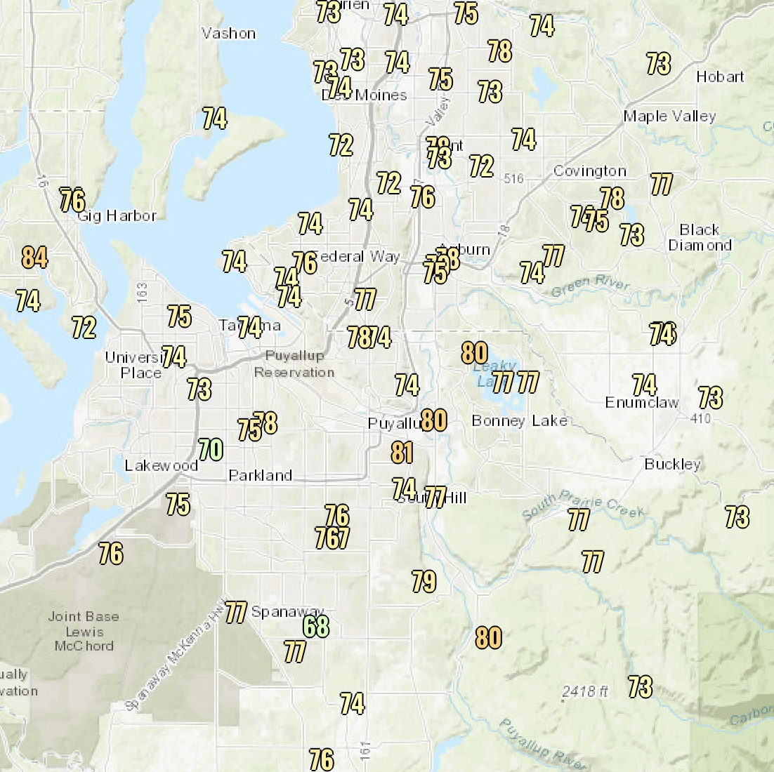
Below, I have made a list of minimum humidity in Puyallup since last Tuesday (4/13).

Tuesday, 4/13: 18%
Wednesday, 4/14: 22%
Thursday, 4/15: 21%
Friday, 4/16: 17%
Saturday, 4/17: 15%
Sunday, 4/18: 17%
Monday, 4/19: 26%
Tuesday, 4/20: 24%

Low humidity over the past week has been a key contributor to the large amount of small wildfires across the state. Average April humidity is 72%, meaning that in the past week, we have had humidity around 52% below average. This, combined with occasionally gusty winds and temperatures of 70-85 degrees, explain the large amount of fires popping up. 

Expect fire danger to decrease by the end of the week and into the weekend, when higher humidity and rain return to the area.

An informative article from The News Tribune is below, talking about the upcoming summer fire season and what the recent fires mean for summer.

We are still a couple months from the start of summer fire season, and while wildfires are generally less frequent west of the Cascades, we saw this past September in Bonney Lake that fires can ignite in Western Washington. 

It's never too early to prepare in the case of a wildfire. Here is a good graphic from the Washington DNR Wildfire Preparedness Site.


Stay safe and check out the links in this blog!


Image found here.


Monday, April 19, 2021

70s Continue Through Wednesday

Monday was cooler than the weekend, with highs making it into the low-mid 70s. We also had higher humidity (less dry) than on Sunday, when humidity was quite low around the area (minimum values below).


Many stations recorded values below 30%, with a few readings in the teens. 

Low humidity coupled with breezy southwest winds did spark a couple brush fires around the area. Fire danger will remain elevated through Thursday due to dry conditions (temps in the 70s & low humidity).

Below is the forecast for Puyallup from Weather Underground.


Expect temperatures in the mid 70s on Tuesday and Wednesday, with increasing clouds on Thursday and Friday and temperatures cooling to the mid 60s. Rain returns late Friday into the weekend.

This is the warmest stretch of weather in April since 2016. Enjoy the sun!


Saturday, April 17, 2021

Warmth Continues Sunday, Gradual Cooldown Ahead

Saturday was the warmest day of 2021 and the warmest since last September. High temperatures are below.


Area high temperatures peaked at 75-85 degrees, including a record-setting 81 degrees at SeaTac Airport.

It was also extremely dry around Puget Sound today, with very low relative humidity. Saturday’s minimum values are below.


Humidity values dropped to 10-25%, higher near water. This was a very dry day, one of the driest in the past year.

Quick announcement: Due to high temperatures, avalanche danger is high in the Cascades, with a high threat of large avalanches. The Northwest Avalanche Center has issued an Avalanche Warning for the Cascades (shown below).


The warmth will continue on Sunday, with highs similar to Saturday. The Puyallup forecast from Weather Underground is below.


There will be an increase in high clouds on Sunday and Monday, and high temperatures remain in the 70s through Wednesday. Temperatures decrease into the mid-upper 60s by the end of the week. Rain looks to make a return by next weekend.

Stay safe and enjoy the sun! This is our warmest April weather in a few years!

Sunny morning at Seahurst Park in Burien, WA, with a view of the Olympic Mountains and a calm Puget Sound. Taken by The_Weatherman2.


Thursday, April 15, 2021

Spring Heat Wave Continues, 80+ Degrees Possible

Thursday was the start of a spring heat wave, with temperatures increasing into the 70s, except near the water. SeaTac Airport set a daily record (75 degrees). High temperatures are below.


Temperatures only increase from here, with even warmer afternoons expected through the weekend. The Weather Underground forecast for Puyallup is below.


Temperatures will likely get near or over 80 degrees on Friday, Saturday, and Sunday. These will be the warmest temperatures of 2021 and the warmest since last September. 

Be sure to take heat-related precautions in the days ahead, including frequent hydration, wearing sunscreen, and being aware of heat-related illnesses. 

Temperatures begin to decline to start next week, with temperatures “moderating” into the low 70s and eventually back to the 60s with clouds and a chance of showers by the end of next week.

This weekend’s high temperatures will be nearly 20 degrees above normal. Record high temperatures are possible as well. Enjoy the warm weather!


Tuesday, April 13, 2021

Spring Heat Wave!

A spring heat wave is ahead! Temperatures will warm into the upper 70s to low 80s by the weekend. Let’s get to the forecast!

Tuesday was a dry and breezy day, with northerly winds blowing towards a low pressure center in the Desert Southwest. Peak gusts are below.


The northerly gusts peaked at 20-35 mph this afternoon (something discussed in the previous blog...showing the accuracy of our forecast models!).

Tuesday’s winds also dried out the air, with humidity dropping below 30% around most of the area.


Humidity dropped to 15-30%, the lowest values since the September fire weather event. If your skin felt dry today...you probably aren’t alone. Be prepared for more low humidity over the next few days.

Now...what you’ve been waiting for...the upcoming heat wave!

Here’s a UW forecast showing the massive high pressure ridge that will be over the PNW on Friday.


As a rule of thumb...high pressure ridges bring sinking air, which produces an absence of clouds. 

Finally, let’s take a look at the forecast for Puyallup from Weather Underground.


The warmup begins on Wednesday, and temperatures peak over the weekend. Subtract a couple degrees from the forecast above if you’re outside the valley. Be sure to take precautions for heat (sunscreen, loose clothing, drink water, etc). Expect temperatures peaking in the upper 70s to low 80s on the weekend. Temperatures slowly decline to start next week and clouds begin to slowly move back in.

Interesting fact...due to offshore flow and compression of air, Western Washington will be warmer than Eastern Washington because air warms as it descends the Cascades, hence 80+ degrees being in the forecast.

The warmest weather since last September is upon us!


Sunday, April 11, 2021

Warm and Sunny Week Ahead

The warmest days of 2021 are expected this week. Before we get to the warmer days, we’ll have another chilly night, with lows around freezing on Monday morning.

Take a look at Sunday morning’s low temperatures. Multiple locations set record lows for April 11th.


Frost was widespread on Sunday morning, and there will likely be patchy frost on Monday morning.

This week will feature high temperatures of 65-80 degrees! This is all due to a large high pressure ridge that will be centered over the Pacific Northwest. The ridge will bring warmer temperatures and dry weather, along with a relative absence of clouds.


You can thank this high pressure ridge for our upcoming spring “heat wave.”

Let’s take a look at the forecast for Puyallup from Weather Underground.


The warmup begins on Monday, when highs go above 60 degrees. By Wednesday and Thursday, temperatures get very near or above 70 degrees! 

Despite the fact that the forecast says it’ll be in the 60s on Monday and Tuesday, it’ll likely feel cooler due to offshore flow (north/east winds). Below is the wind forecast for Puyallup.


Winds gusting up to 30 mph are possible on Monday and Tuesday, mainly from midmorning to sunset.

Looking later into the week, the real heat builds. There is now a significant chance that temperatures will reach or get above 75 degrees. The forecast from Weather Underground even shows temperatures reaching 80 degrees, very warm for spring!


I will have more updates on the potential of temperatures near 80 degrees as we get closer to the end of this week when temperatures peak.

Friday, April 9, 2021

Front Bringing Rain & Much Colder Temperatures, Then A Major Warmup

A front will move into Western Washington Friday night. This front will bring rain, mountain snow, breezy winds, and colder temperatures. 

Below is the UW forecast for rain through 5 AM Saturday.


Besides a visible rain shadow just north of Seattle, most areas will receive 0.05 to 0.25 inches of rain.

This front will bring snow to the mountains. Below is a graphic from NWS Seattle showing expected snow accumulations through 5 PM Saturday.


Expect 4-12 inches at the mountain passes. While this isn’t a huge amount of snow, it is impactful at this point in the year.

This front will also bring a big drop in temperatures and the snow level will plummet. There is a slight chance of rain/snow mix in the lowlands early Saturday morning. This is relatively unlikely, but be prepared for brief wintry mix.

The front will also bring breezy conditions to the lowlands on Friday evening and into Saturday. The wind forecast for Puyallup is below.


The strongest winds around the area are expected overnight, as the frontal passage brings winds gusting up to 35 mph.

Due to the incoming front, temperatures near or below freezing are likely on Sunday morning. Below is the Puyallup forecast from Weather Underground.


Notice 3 things in this forecast:
 

1) the front will bring rain on Friday night/early Saturday. 

2) cold temperatures are likely on Sunday and Monday mornings. (The low temperature value for a given day normally corresponds to the next morning’s low) Be prepared for frost and freezing temperatures if you have plants growing.

3) A major warmup and transition to at least a week of dry conditions begins on Sunday. 

Below is the extended forecast for next week. (For Puyallup, from Weather Underground).


The warmest temperatures since last September are ahead, with highs exceeding 70 degrees on multiple days next week. And...after a wet fall and winter, we will likely have at least one week without rain! 


Wednesday, April 7, 2021

Next System Arrives Late Friday, Then Much Warmer Temperatures

Wednesday felt more like January than April, with high temperatures (shown below) barely getting over 50 degrees.


Occasional rain and breezy conditions were present around the area on Wednesday as well. Expect an additional few hundredths of an inch of rain late Wednesday into early Thursday morning.

The next system moves in late Friday. Thursday and Friday will be partly cloudy with highs in the mid 50s. The forecast for Puyallup from Weather Underground is below.


Around 0.1-0.2 inches of rain is possible late on Friday. Notice the near to below freezing temperatures early on Sunday and Monday. Some frost is possible, so be prepared if you have plants.

Looking further ahead, significantly warmer temperatures are possible next week. Current forecasts suggest high temperatures of 65-75 degrees. The Puyallup forecast from Weather Underground shows the warmup.


The change to warmer temperatures is reflected in the NWS Climate Prediction Center’s temperature outlook for April 13th-17th.


The outlook shows a 50-60% chance of above average temperatures.

In the next few days, I’ll have updates on the warmer temperatures in the forecast.


Monday, April 5, 2021

Warmer on Tuesday, Rain Returns Wednesday

This week began with a chilly morning for April, with low temperatures 10-15 degrees below average. Area low temperatures are below.


The cold temperatures brought frost around the area, late in the season but not necessarily rare.

Looking ahead, a partly sunny day with highs in the low 60s is expected on Tuesday, before rain and cooler temperatures arrive on Wednesday. Weather systems bring rain to the area on Wednesday and Friday, with drier days between systems. (Weather Underground forecast below). 


Tuesday morning lows may drop into the mid 30s, but won’t be as cold as Monday morning due to the presence of low clouds. Notice that high temperatures take a significant drop on Wednesday, rebound a bit to the mid 50s on Thursday, then stay in the low 50s to end the week.

The Wednesday rain forecast from the UW model is below.


This forecast ends 5 AM Thursday. Expect 0.1-0.2 inches of rain for the lowlands (isolated higher amounts), with more rain on mountain slopes & the coast, and a rain shadow evident downwind of the Olympics.

Below average temperatures will continue in the Pacific Northwest, but there are signs of more consistent high temperatures of 60+ degrees by next week.


Saturday, April 3, 2021

Easter Forecast: Large Temperature Drop, Chance of Showers

Saturday was the warmest day of 2021 (high temperatures below), with temperatures generally reaching 60-67 degrees around the area.


High temperatures on Easter Sunday will struggle to reach 50 degrees, a 10-15 degree drop from 24 hours before. Then, low temperatures on Sunday night/Monday morning will reach 30-35 degrees, with a late-season frost possible.

Additionally, there’s a chance of rain through midday Sunday. The UW forecast is below.


Expect light rain, totaling 0.03-0.1 inches. 

The Puyallup forecast from Weather Underground is below.


Temperatures barely reach 50 degrees on Sunday, with low temperatures near freezing by Monday morning. Sun and dry weather, with highs near 60 degrees, returns on Monday and Tuesday. Somewhat chillier weather and a rainy few days begin on Wednesday.

Happy Easter!


Short Spring Heat Wave for the Pacific Northwest

  FastCast--Thursday, May 9 to Tuesday, May 14: A spring "heat wave" is ahead for the Northwest, with the warmest temperatures see...