Monday, February 27, 2023

Another Marginal Snow Event for Monday Night & Tuesday

No FastCast tonight...continue reading the full blog below!

It has been the tale of this winter...marginal snow event after marginal snow event. Another one is ahead for late Monday night through early Tuesday. Snow will largely depend on the temperature, elevation, and the precipitation rate (heavier precipitation = more snow coming to the surface).

Snow will be most likely early Tuesday morning, approximately from 6-10 AM. Showers late Monday night and on Tuesday night/Wednesday morning could also bring light snow, which is why we will show forecasts below through Wednesday morning.

Let's start with the European model forecast 10 AM Wednesday.


The European model shows a dusting to 1” of snow from Seattle south to Portland. The Kitsap Peninsula, Hood Canal, areas Seattle northward, and around Portland could get 1-4”, most possible near Portland, in the foothills north of I-90, and in Whatcom County. In Eastern Washington, expect up to 4”, most outside the Lower Columbia Basin.

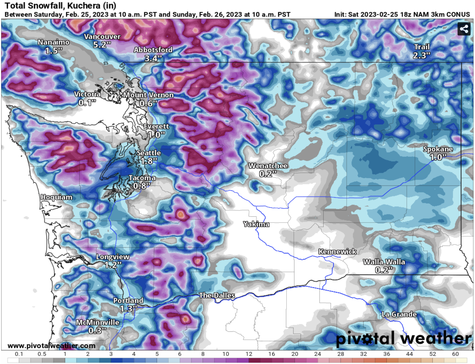
Next, the NAM high-resolution forecast, also through 10 AM Wednesday.


This forecast shows scattered snow, with accumulations of 0.25-3” scattered from Longview northward, most from Seattle to Skagit County. This also shows up to 8” for Eastern Washington, most from the Tri-Cities to Spokane.

Next, the HRRR high-resolution forecast through 10 AM Wednesday.


This forecast shows 1-4” of snow from Olympia southward, including on the coast. This also shows 1-3” from Everett northward, 2-6” around Spokane, and 1-4” on the coast from Hoquiam northward and from Astoria south. This forecast is an outlier.

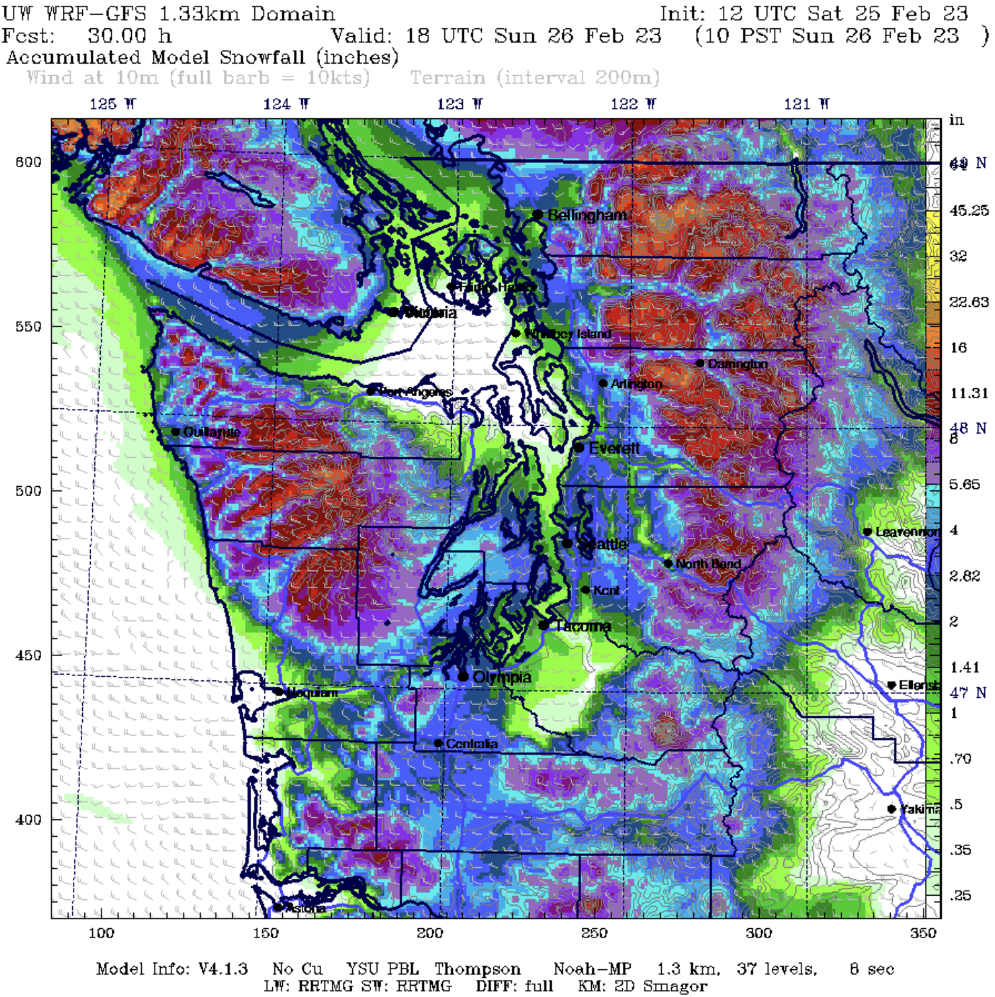
Finally, the UW WRF ultra-high resolution forecast through 10 AM Wednesday.


This shows 0.5-1.5” from Olympia to Seattle and 2-4” from Seattle northward. This also shows an unlikely 8-16” near the NW tip of WA near Forks, Neah Bay, and Western Clallam County. This forecast is likely an outlier, especially for the NW WA Coast.

Putting this all together in one forecast:

Portland: 1-4”
Portland to Olympia: 0-2”
Olympia to Seattle: 0-1.5”
Seattle to Canadian Border: 1-4” (less near water)
Hood Canal Area/Kitsap Peninsula: 1-4”
Coast from Hoquiam northward: 0-4” (less near the ocean)

It is likely that highs in the low to mid 40s and lows in the low 30s are going to continue for awhile, with more marginal snow chances ahead. Stay tuned!

Sunday, February 26, 2023

More Lowland Snow Chances on Monday

No FastCast tonight…keep reading below for the next snow chances.

After a system brought snow to most of the lowlands early Sunday, another weak system will bring a chance of snow to parts of the region again on Monday. Again, this will be a marginal system, so rain/snow mix and sharp snow cutoffs are possible. The highest chance of snow is through Monday morning, while temperatures are still near freezing.

Let’s start with the European model’s forecast through 4 PM Monday.


The European model shows 0.2-1.5” of snow for the lowlands, with 1-3” on the North Coast and near Hood Canal. Areas in SW WA and Portland could get 1-2” in this situation, and the mountains get 6-10”.

Next, the NAM high-resolution forecast through 4 PM Monday.


The NAM shows little snow from Olympia to Everett, but 0.2-1” from Olympia south and from Everett north, with higher amount of 1-3” on the North Coast and 3-6” near Hood Canal. This shows 1-3” of snow at the passes, diminishing possible impacts.

Next, the HRRR high-resolution forecast, also through 4 PM Monday.


The HRRR shows 0.5-1” of snow scattered around the lowlands, mainly from Olympia to Mount Vernon, with 2-4” around Portland and 1-3” on the North Coast. This shows 3-6” at Snoqualmie Pass and 6-12” at Stevens Pass.

Finally, the UW WRF high-resolution forecast, through 4 PM Monday.


The UW forecast shows 1-4” of snow from Tacoma south and on the Kitsap Peninsula, with some areas of 0.5-1” from Everett to Bellingham, plus 1-3” on the North Coast. This forecast gives the passes 1-6”, with more at Snoqualmie and White Passes.

So, putting this all together:

Everett to Vancouver BC: 0-1”

Olympia to Everett: 0-2”

Olympia to Portland: 0.25-3”

Coast from Hoquiam to Cape Flattery: 1-4”, more away from the ocean

Hood Canal Area & Kitsap Peninsula: 1-4”, isolated 4-6” near Hood Canal

Passes: 1-8”

Another chance of snow is expected from late Monday to Tuesday. Stay tuned to the next blog!

Saturday, February 25, 2023

A Complex Snow Forecast for Saturday Night to Sunday Morning

No FastCast today. Continue reading the full blog below.

A complex snowstorm forecast is ahead for late Saturday night through Sunday morning. Temperatures will be marginal, with snow amounts varying across the region. Let’s take a look at some forecasts and why this event is so marginal.

-Temperatures are above freezing, and will only go below freezing due to evaporative cooling, where precipitation falling through the atmosphere brings cooling.

-With marginal temperatures, precipitation may stay as rain/snow mix or all rain for some areas.

-Temperatures will quickly warm up early Sunday morning, with a changeover to rain possible before sunrise.

First, let’s look at the European model, shown below through 10 AM Sunday.


The European model forecast shows 0.5-1.5 inches for most of the lowlands from Olympia to Skagit County. Whatcom County will likely pick up 1-3”. The snow winners with this system will be areas along Hood Canal, the Kitsap Peninusla, and areas from Olympia south to Clark County, which will all get 2-6”. Areas will be snow-shadowed NE of the Olympic Peninsula and in Pierce & SE King Counties.

Next, the ultra high-resolution UW WRF model, showing total snow through 10 AM Sunday.


The UW WRF forecast shows roughly the same as the European, with snow shadows NE of the Olympic Peninsula and for Pierce County. This forecast is a bit snowier, with most of the lowlands picking up 1-3”, with isolated totals up to 4”, mainly in the foothills and from Everett northward. The Hood Canal area, Kitsap Peninsula, and areas from Olympia south to Vancouver get 4-6” in this snowier scenario.

Next, the NAM high-resolution forecast, also through 10 AM Sunday.


The NAM shows a less snowy scenario for most of the region, except a band from the Kitsap Peninsula to the Snoqualmie Valley, where it shows 2-4”. The NAM has a pronounced snow shadow for South King & Pierce Counties and areas along the Strait, Whidbey & Camano Islands, and Western Skagit County. Areas from Olympia south to Portland get 1-3”, and Hood Canal/Kitsap Peninsula win with 3-6”. 

Finally, the HRRR high-resolution forecast through 10 AM Sunday.


The HRRR shows a very snowy forecast, with snow shadowed areas in Island and Pierce Counties getting a trace to 0.5”, and most other lowland areas getting 1.5-4”. This forecast shows the Kitsap Peninsula and Hood Canal areas getting 6-8”. This is an outlier and is generally unlikely to happen.

Putting this all together into one forecast:

Whatcom County: 1-4”

NE Olympic Peninsula Rain Shadow Area: 0-0.5”

SeaTac to Skagit County: 0.5-3”

SeaTac to Olympia: Trace-2”

Olympia to Portland: 1-4”

Hood Canal Area/Kitsap Peninsula: 2-6”, isolated 6+”

More marginal snow events are possible in the coming days, including residual snow-producing showers later on Sunday. Stay tuned! (Twitter link in top right of blog…frequent updates!)

Thursday, February 23, 2023

Coldest Night of 2023 Ahead, Weekend Snow Update

No FastCast tonight…keep reading below for an update on the frigid temperatures.

After a frigid day on Thursday, an even colder morning is ahead on Friday. Below is the European model forecast for Friday morning’s lows.


Expect lows in the upper teens to low 20s for the lowlands, with some isolated locations in the mid teens, including areas from Portland to Chehalis. Eastern Washington will drop into the low single digits to mid teens, with mountainous areas dropping from -5 to -10º. 

Wind chills will also be quite frigid on Friday morning, as seen in the European model forecast for 7 AM.


Expect another morning with very cold wind chills in the single digits to mid teens for the entirety of Western Washington. Southwest WA and the Willamette Valley will have wind chills in the single digits. Eastern Washington will have wind chills from -15 to the low single digits. Frostbite can occur much quicker anywhere with wind chills in the single digits or lower. Be sure to bundle up when going outside!

One positive is that Friday’s highs will be a few degrees warmer, as seen in the European model forecast below.


Expect highs in Western Washington in the mid to upper 30s, although highs in Eastern Washington will remain below freezing, likely in the low to mid 20s.

One quick note…has it seemed quite dry? That is because the dewpoints (measure of temperature where water condenses and forms dew) are incredibly low. Take a look at the European model forecast for dewpoints at 10 AM Friday.


The European model shows very low dewpoints in the single digits to low 20s for most of Western Washington, with some areas (mainly Eastern WA) having dewpoints as low as -10 to -15º! That will make your skin very dry!

Now, a look at the two major forecast models for the potential weekend snow, which is most likely from very late Saturday through early Sunday morning, with residual showers possible Sunday night. First, the European model, showing snow through Sunday evening.


The European model shows 0.5-2” of snow for the lowlands, with more (2-4”) from Olympia south to Portland and from Mount Vernon northward. Notice the snow shadow for the NE Olympic Peninsula, where the typical rain shadow is.

Next, the GFS model, also showing snow through Sunday night.


The GFS is more ambitious with snow, showing 2-4” for most of the region, except the “snow shadow” for the NE Olympic Peninsula and Whidbey Island.

Stay tuned over the next couple days as this forecast becomes clearer!

Wednesday, February 22, 2023

Frigid Temperatures, Dangerous Wind Chills, and More Snow Ahead

No FastCast tonight...keep reading below for more information on the very cold weather ahead.

Lots of winter weather impacts are ahead for the Pacific Northwest over the next few days, as a massive winter storm spreads across the country.

Note on snow: Very dry air (humidity 30-50%) will make it quite hard for snow to fall anywhere north of Tacoma and from Puget Sound eastward. Snow is possible most of the night for the Hood Canal area, accumulating 2-4". Remaining snow will freeze overnight, with icy spots possible for the morning commute.

Let's start with low temperatures. Below is the latest European model forecast for Thursday morning's lows.


Persistent cloud cover will keep temperatures mainly in the mid 20s for the lowlands, with colder lows in the low 20s possible for the foothills. Eastern Washington will be very cold, with lows in the low single digits to mid teens, with some mountainous areas dropping below zero.

Gap winds overnight will bring very cold, sometimes dangerous, wind chills through the day Thursday. Expect peak gap wind gusts of 20-30 mph in the lowlands and 40-50 mph in the foothills, mainly from North Bend to Enumclaw. Additionally, strong Fraser River outflow winds will continue gusting 30-50 mph in Whatcom and San Juan Counties, bringing dangerous wind chills and potential freezing spray on the water.

Below is the European model's forecast for wind chills at 7 AM Thursday.


At 7 AM, expect wind chills in the teens for most of Western Washington, with the coldest temperatures in the upper single digits to low teens in the foothills, Whatcom & San Juan Counties, and from Puyallup to Seattle. In Eastern Washington, morning wind chills will range from -20 to 0, with frostbite possible in under 30 minutes on exposed skin.

Next, let's take a look at wind chills by 1 PM Thursday.


It's safe to say that Thursday will not be warm. Most of the lowlands will have wind chills remaining in the 20s, with wind chills in the low 20s likely around midday for most areas. Eastern Washington will have wind chills of -10 to +20 around midday.

As you'd expect, high temperatures on Thursday will struggle to get out of the 30s. Below is the European model's forecast for highs on Thursday.


Generally, expect highs in Western Washington to be in the low to mid 30s, and in the low teens to mid 20s in Eastern Washington. Any remaining snow won't melt easily on Thursday, and any wet spots will briefly melt or remain frozen.

Once the sun sets, wind chills will drop back into the teens for Western Washington and the -20 to +10 range for Eastern Washington.

The same conditions are expected on Friday, but we will review that in the next blog. 

Confidence is increasing in a region-wide snow event from later Saturday into early Sunday. Timing and exact amounts still vary and will definitely change, but a decent possibility of a forecast is below (European model, total snow through Sunday evening.


1-3 inches is a good bet as of now for most of the lowlands, excluding areas from North Seattle to the San Juans, where the traditional "rain shadow" is now more of a snow shadow.

Remember that amounts, timing, and how much snow will stick around is all likely to change. Stay tuned, as I will have lots more updates on the continued winter weather!


Tuesday, February 21, 2023

500th Post Special: Update on Potential Snow & Frigid Temperatures

500th Blog Post for The_Weatherman2

500 blog posts later, we still don't know where, when, or if it will snow in the lowlands! My first post on this blog, on January 16th, 2020, was about lowland snow. Tonight, we're again talking about snow, but also about the upcoming significant cold.

Let's start with the high-resolution snow forecasts. First is the NAM forecast through Wednesday night.


The NAM shows spotty areas of a trace to 1" of snow around the lowlands, with the highest amounts of 2-6" possible on the northern Olympic Peninsula, especially around Port Angeles and Sequim.

Now for the HRRR forecast, also through Wednesday night.


The HRRR shows pockets of snow around the lowlands, mainly from Seattle north and on the Kitsap Peninsula. It agrees with the NAM in showing snow on the Olympic Peninsula, about 0.5-3" near the coast, and up to 2-6" along the Strait and in the mountains. The HRRR also shows snow from Olympia southward, with 1-3" possible in the Willamette Valley.

Finally, the European model, historically the most accurate in snow situations around the Pacific Northwest.


The European model shows spotty pockets of a trace to 1" of snow around the lowlands, 1-3" for the Northern Olympic Peninsula, and 1-4" for most of Eastern Washington, except less around Yakima and the Tri-Cities.

What about temperatures? Quite the chill is coming. Winds will accelerate out of the Fraser River Gap, gaps in the Cascades, and the Columbia River Gorge, as Arctic high pressure builds east of the mountains. With cold air in place, frigid wind chills and very cold mornings are expected.

Below is the European model forecast for Wednesday morning's lows.


Wednesday morning won't be too cold, with lows in the low to mid 30s for the lowlands, in the upper 20s for some outlying areas, and much colder, in the low teens to low 20s for Eastern Washington.

However, brisk winds from the north will make it feel much colder across the state. Below is the European model forecast for wind chills at 7 AM Wednesday.


Brisk northerly winds will bring wind chills (feels-like temperatures) in the low to mid 20s for most of the lowlands, except in the upper teens for Whatcom, San Juan, and Clallam Counties, which are more exposed to the Fraser winds. Eastern Washington will have wind chills in the -5 to +15 degree range.

Highs on Wednesday will reach the upper 30s to low 40s for the lowlands and mid 20s to low 30s for Eastern Washington. However, wind chills will keep feels like temperatures in the upper 20s to low 30s for Western Washington and low single digits to mid teens for Eastern Washington.

Temperatures get significantly colder overnight Wednesday into Thursday. Below is the European model forecast for lows on Thursday morning.


Expect Thursday morning's lows in the low to mid 20s for most of the lowlands, with outlying areas near the foothills dropping into the upper teens. Eastern Washington will drop to the low single digits to mid teens, except below zero in mountainous areas.

From late Wednesday into Thursday, winds will shift from northerly (out of the Fraser Gap) to easterly (out of gaps in the Cascades, near Enumclaw & North Bend). This will bring frigid wind chills Thursday morning, as seen in the European model forecast below.


Gap winds will bring frigid wind chills to the lowlands, likely in the upper single digits to mid teens. Eastern Washington will be in the freezer, with wind chills of -20 to +10. The Portland area will also have wind chills in the upper single digits to mid teens, due to winds out of the Columbia River Gorge.

While snow is quite uncertain, confidence is high in significant cold. Begin making preparations now to protect people, pets, and plants (the 3 P's of cold weather). Remember that being outside for long periods of time with these wind chills causes frostbite to occur much sooner. Stay tuned!

--------------------------------------------------------------------------

A Special Note:

As I look back on 500 blog posts since 2020, I want to say a special thank you to all my readers, especially those who have been following along for a long time. You all are what make this blog possible, and I look forward to writing many more posts in the future! Thank you for reading!

-The_Weatherman2

Monday, February 20, 2023

Update: Significant Storm Impacting the Pacific Northwest

No FastCast tonight...storm update below!

A plethora of weather impacts are expected and ongoing across the Northwest tonight. 

Let's start with wind. Winds are increasing across the region as of 8 PM Monday. Let's take a look at the NAM high-resolution forecast for winds Monday night.


According to the NAM, expect gusts of 35-45 mph for the lowlands. Eastern Washington will gust 45-55 mph, except 55-65 mph south of I-90 and on the immediate East Slopes and foothills. A strong westerly wind surge is expected down the Strait of Juan de Fuca, with peak gusts of 50-65 mph along the Strait, Whidbey Island, and the Admiralty Inlet area.

Next, let's look at the HRRR forecast for wind gusts late Monday night.


The HRRR forecast shows peak gusts of 35-45 mph around the lowlands and 45-55 mph across Eastern Washington. The HRRR shows strong westerly winds down the Strait gusting 45-55 mph, including near Everett and Mukiltieo. The HRRR shows gusts up to 55-60 mph on Whidbey and Camano Islands.

Expect potential tree damage and isolated power outages across the lowlands. Wind impacts are most likely near the westerly wind surge along the Strait, Whidbey and Camano Islands, and the Admiralty Inlet area.

Now to the snow...Heavy mountain snow is expected through late Tuesday, with impacts expected on the passes. Below is the NAM high-resolution forecast for snow through Wednesday night.


The NAM shows 12-18 inches at Snoqualmie Pass and 18-30 inches at Stevens Pass. It also shows light snow in the lowlands (trace to 1") from Seattle north to Skagit County, 1-2" from Chehalis south into Oregon, and a trace to 6+" in Eastern Washington.

Next, the HRRR forecast, also showing snow through 


The HRRR shows 12-18" at Snoqualmie and 18-24" at Stevens. The HRRR is more aggressive with lowland snow, showing a trace to 3" for most lowland areas from BC to the Willamette Valley (this is an outlier).

Finally, the UW WRF high-resolution forecast through Wednesday night.


The UW forecast shows 12-18" at Snoqualmie and 18-24" at Stevens, with 0.5-3" in the lowlands from Skagit County southward. This lowland snow solution is also an outlier. 

Expect impacts over the mountain passes through early Wednesday, with heavy snow at times and possible blowing snow. Lowland snow is possible in residual showers from Tuesday evening through late Wednesday. Stay tuned for more information in coming blogs.

Finally, a quick update on the incoming cold weather. From Tuesday evening through Wednesday morning, winds will shift from southerly to northerly, bringing in arctic air and frigid wind chills across the state. Then, winds will likely turn easterly, accelerating gap winds across the foothills and Central Sound by Thursday morning.

Below is the European model forecast for wind chills at 7 AM Thursday.


This is a good representation of the upcoming morning wind chills. Expect wind chills to drop into the low to mid teens for the entirety of Western Washington, with isolated readings in the single digits, most likely near the foothills and Whatcom County. 

Finally, a brief look at expected low temperatures on Thursday morning, from the European model.


Expect lows in Western Washington to be in the low to mid 20s, with outlying areas reaching the upper teens. Eastern Washington will be frigid, with lows in the low single digits to mid teens, with mountainous areas and NE WA dropping below zero.

Stay tuned for updates as this active weather continues!

Sunday, February 19, 2023

Mountain Snow, Winds, Rain, and Dangerous Cold Ahead

No FastCast today, keep reading below for a summary of the active weather ahead for the Pacific Northwest.

A lot of active weather is ahead for the Northwest, with heavy mountain snow, strong winds, rain, and very cold temperatures ahead. Let's take a look at the forecasts.

Quick note: Avalanche Warning in effect for Snoqualmie and Stevens Passes through Monday evening. Check avalanche forecasts at the Northwest Avalanche Center (NWAC).

Below is the European model forecast for snow through Wednesday evening.


The European model shows 12-18 inches at Snoqualmie Pass and 24-36 inches at Stevens Pass through midweek. Most of Eastern Washington (outside lower elevations of the Basin) will get 1-3 inches, except 5-8 inches near Wenatchee. 

Let's compare this to the UW WRF model, also showing snow through Wednesday morning (shorter than the European model).


The UW forecast shows 12-18 inches at Snoqualmie Pass and 24-36 inches at Stevens Pass, similar to the European model.

In short, be prepared for significant winter storm conditions crossing the passes from Monday through Tuesday, with challenging conditions still possible on Wednesday. Be prepared for delays and closures if crossing the state. Note: Snoqualmie Pass will remain mostly rain on Monday, before transitioning to snow late Monday night.

With a strong system moving into the region from Monday through Tuesday, there will be a large area of onshore flow, bringing gusty winds for most of the state.

Below is the European model, showing peak gusts early Tuesday morning, likely peak winds for Western Washington.


Generally, expect gusts 35-45 mph for Western Washington, except 50-65 mph westerly gusts along the Strait, Whidbey Island, and Admiralty Inlet. Eastern Washington and the Cascades will experience gusts of 50-60 mph, peaking early Tuesday morning. Some blowing snow is possible for the Cascades.

Let's take a look at the total rain expected for Western Washington through Wednesday morning.


Generally, expect 0.3-0.9 inches from Tacoma northward, with 0.2-0.4 inches from Tacoma south. On the coast and from Everett northward, expect 1-1.5 inches. 

Finally, a look at the upcoming cold temperatures. The coldest temperatures don’t arrive until late Wednesday night, likely continuing through Friday morning. Coldest temperatures will be in the mornings.

Below is the European model forecast for lows on Thursday morning.


In Western Washington, expect lows in the mid 20s, except the low 20s in Whatcom County, the Willamette Valley, and the Cascade foothills. In Eastern Washington and the Cascades, expect frigid lows from zero to the low teens, with some isolated readings below zero.

Another big issue with the cold temperatures will be the frigid wind chills due to brisk northerly outflow winds. Below is the European model forecast for wind chills around 7 AM Thursday.


Dangerous wind chills are possible, likely dropping to the upper single digits to mid teens for Western Washington and from zero to -20 for Eastern Washington.

Details on the frigid temperatures and dangerous wind chills are still evolving, so stay tuned. I’ll have another blog Monday night with updates on the mountain snow, winds, and potential (slight chance) lowland snow.


Friday, February 17, 2023

Major Mountain Snow, Arctic Blast Looming

 FastCast—Saturday, Feb. 18 to Tuesday, Feb. 21:

An unsettled but mostly calm weekend is ahead across the region. Expect mostly cloudy conditions with a chance of showers, likely totaling 0.1-0.2 inches in the lowlands. Highs will reach the mid to upper 40s, with lows in the upper 30s to mid 40s. Through the weekend, Snoqualmie Pass will receive 4-8 inches of snow, with 8-16 inches at the higher passes. Some travel delays are possible. A much more robust system arrives on Monday, continuing through Tuesday, bringing 0.4-0.9 inches of rain to the lowlands and major mountain snows. Expect totals of 12-24” at Snoqualmie Pass and 24-36” at Stevens and White Passes, though those amounts are still changing. The lowlands will begin turning colder late Tuesday, but details about that transition, and potential snow chances, remain uncertain. Be sure to stay tuned to upcoming blogs.

——————————————————

Continue reading the full blog below!

Major mountain snows are ahead for the Cascades, with an Arctic blast looking likely for the entire region around the middle to end of next week. Let’s take a look at some forecasts.

Below is the European model forecast for snow through Tuesday night.


This forecast shows major mountain snow, with 24-36” at Snoqualmie and White Passes, and up to 36-48” at Stevens Pass. Most snow will fall from Monday to Tuesday, but amounts are still changing as models struggle with snow levels and temperatures on Monday, which could change snow totals.

Let’s compare this with the NWS NBM high-resolution forecast, also showing snow through Tuesday night.


This forecast shows a bit less snow than the European model, probably a bit more realistic as of now. This forecast shows 12-24” at Snoqualmie and White Passes and 24-36” at Stevens Pass. 

Travel delays are expected, so continue monitoring the latest alerts and forecasts regarding mountain snow.

All of this mountain snow through Tuesday means that the lowlands will be picking up the first significant rain of February. Below is the European model forecast for rain through Tuesday night.


Expect 0.4-1.5” of rain in the lowlands, with even more possible between Everett and Bellingham. On the coast, expect 1-1.5”. 

Finally, it is now very likely that much colder than normal temperatures will occur from the middle to end of next week and possibly beyond. Below is the NWS Climate Prediction Center outlook for temperatures from February 23-27 (next Thursday to the following Monday).


Wow! The scale is maxed out over the Western US, with the almost the entire Pacific Northwest under an 80-100% probability of below average temperatures. This high a probability suggests that temperatures will be significantly below average.

However, details on these temperatures are still uncertain, so stay tuned to upcoming blogs! What is certain is that very cold temperatures and potentially hazardous wind chills are in store, so have that in the back of your mind as we enter next week. Stay tuned!

Tuesday, February 14, 2023

Cold Mornings & the Potential for More Cold Weather

 FastCast—Wednesday, Feb. 15 to Sunday, Feb. 19:

Multiple Convergence Zone bands brought thunderstorms, lowland snow, and accumulating hail on Monday. Areas from SeaTac to Graham and from South Whidbey Island to Lake Stevens got snow. The highest snow accumulations were in Southern and Eastern King County, with 1-3 inches, most in the foothills. Quite a cold morning is ahead on Wednesday, with lows dropping to the mid 20s for most of the lowlands. Expect increasing clouds on Wednesday, with highs in the upper 40s, melting most remaining snow. Thursday morning will also be chilly, with lows in the upper 20s to low 30s. Conditions moderate through Sunday, with mostly cloudy conditions and highs in the upper 40s, with lows in the mid 30s to low 40s. A weak system late Thursday to early Friday will bring brief light rain and a slight chance of brief light snow. Another shot at active & cold weather is possible in the middle of next week, so stay tuned for more information.

—————————————————————

Continue reading the full blog below!

Cold air made its presence known around the lowlands on Monday night, bringing lowland snow for many locations, but not all. However, all locations will feel this round of cold air’s final act on Wednesday morning. Take a look at the European model forecast for Wednesday morning’s lows.


Around the lowlands, expect lows in the mid 20s, except closer to the upper 20s near the water and in the 30s on the coast and along the Strait, Admiralty Inlet, and the San Juans. The Willamette Valley will drop into the low to mid 20s, and Eastern Washington will reach the upper teens to mid 20s.

Similar lows, except more in the upper 20s to low 30s in the lowlands, are expected on Thursday morning as well.

Conditions will return to a more typical cloudy and calm pattern for the remainder of this week, with a weak system late Thursday to early Friday bringing brief light rain and a potential for brief light snow (though not likely…but watch temperatures late Thursday into Friday morning).

Now, let’s take a look at the potential for an Arctic blast next week. We are just over a week out from this prediction for next Wednesday (23rd). Note the yellow box, showing a polar lobe, or Arctic air from Canada moving into the Northwest.


This feature has shown up on the European, American (GFS), and Canadian (GEM) models, despite being over a week out. While this is still too far away to make solid predictions, there is a decent potential for at least more cold temperatures next week. 

That increased chance of cold temperatures is reflected in the NWS Climate Prediction Center temperature outlook for February 22-28.


This outlook shows a 70-80% probability of below average temperatures for most of the Pacific Northwest for the last 6-7 days of February.

It is too early to make specific predictions about this potential cold pattern, but stay tuned as details become clearer.

——————————————————

I received 1.5” of snow at my house in Federal Way on Monday night. This was near the upper end of forecasts. Take a look at a few photos from the event…the snowflakes were huge (indicating they’re close to melting), and the snow was very wet. While it can be a nuisance, snow does make most surroundings prettier!


Short Spring Heat Wave for the Pacific Northwest

  FastCast--Thursday, May 9 to Tuesday, May 14: A spring "heat wave" is ahead for the Northwest, with the warmest temperatures see...