No FastCast tonight…keep reading below for an update on the frigid temperatures.
After a frigid day on Thursday, an even colder morning is ahead on Friday. Below is the European model forecast for Friday morning’s lows.
Expect lows in the upper teens to low 20s for the lowlands, with some isolated locations in the mid teens, including areas from Portland to Chehalis. Eastern Washington will drop into the low single digits to mid teens, with mountainous areas dropping from -5 to -10º.
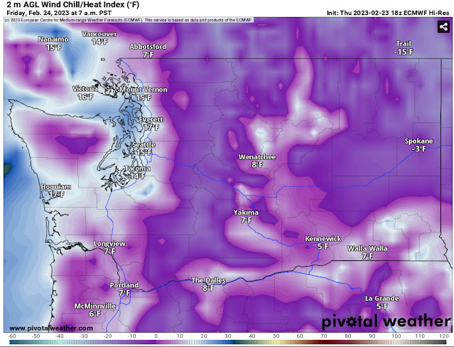
Wind chills will also be quite frigid on Friday morning, as seen in the European model forecast for 7 AM.
Expect another morning with very cold wind chills in the single digits to mid teens for the entirety of Western Washington. Southwest WA and the Willamette Valley will have wind chills in the single digits. Eastern Washington will have wind chills from -15 to the low single digits. Frostbite can occur much quicker anywhere with wind chills in the single digits or lower. Be sure to bundle up when going outside!
One positive is that Friday’s highs will be a few degrees warmer, as seen in the European model forecast below.
Expect highs in Western Washington in the mid to upper 30s, although highs in Eastern Washington will remain below freezing, likely in the low to mid 20s.
One quick note…has it seemed quite dry? That is because the dewpoints (measure of temperature where water condenses and forms dew) are incredibly low. Take a look at the European model forecast for dewpoints at 10 AM Friday.
The European model shows very low dewpoints in the single digits to low 20s for most of Western Washington, with some areas (mainly Eastern WA) having dewpoints as low as -10 to -15º! That will make your skin very dry!
Now, a look at the two major forecast models for the potential weekend snow, which is most likely from very late Saturday through early Sunday morning, with residual showers possible Sunday night. First, the European model, showing snow through Sunday evening.
The European model shows 0.5-2” of snow for the lowlands, with more (2-4”) from Olympia south to Portland and from Mount Vernon northward. Notice the snow shadow for the NE Olympic Peninsula, where the typical rain shadow is.
Next, the GFS model, also showing snow through Sunday night.
The GFS is more ambitious with snow, showing 2-4” for most of the region, except the “snow shadow” for the NE Olympic Peninsula and Whidbey Island.
Stay tuned over the next couple days as this forecast becomes clearer!


No comments:
Post a Comment