Monday, May 30, 2022

Wetter, Colder, and Snowier: May 2022 By the Numbers

May 2022 has been anything but a normal spring month. The entire month was dominated by above average rain and below average temperatures. 

The Western Region Climate Center (WRCC) graphic below shows the percent of average rain across Western Washington in May.


Most of Western Washington received 130-300% of normal rainfall. Specifically, the entirety of the lowlands received at least 130% of average.

How much rain actually fell around the area? Take a look at these maps below.


Normal precipitation for May in the Seattle area is around 1.9 inches…so this month was around 1.5-3.5 inches above normal in the lowlands and up to 5 inches above normal in the foothills! Some locations high up in the Olympics and Cascades even received over a foot of rain!

In addition to being wetter than normal, this May was much colder than normal. The WRCC graph below shows the temperature departure from average across the state in May.


The entire state had temperatures below normal, with the majority of the state being 2-6 degrees below normal.

The temperature departure from normal is even more striking when looking only at daily high temperatures, as seen below.


High temperatures in May were 4-8 degrees below normal across most of Washington State, including being at least 6 degrees below normal in nearly all of Eastern Washington. Some locations in the mountains were even 8-10 degrees colder than average!

The biggest impact of this May’s abnormally wet & cold conditions will be the snowpack. The USDA map below shows snowpack percent of average on May 30th.


Wow! All snowpack in Washington State is 140-430% of normal! This is very good news for the upcoming dry season. Any water supply worries are gone, and the wildfire season’s start will likely be delayed thanks to this excess snowpack.

So…while May was wetter, colder, and snowier than normal…it will likely have a positive impact on conditions this summer.

Sunday, May 29, 2022

Stretch of Warmer Weather to Start June

FastCast—Monday, May 31 to Friday, June 3:

After a chilly and 10-15 degree below average weekend, warmer weather is ahead! Memorial Day will be mostly cloudy and in the upper 50s to low 60s, similar to Saturday and Sunday, but drier. The warmup begins on Tuesday, with high temperatures reaching the upper 60s to low 70s, along with partly sunny conditions. Partly sunny skies will continue on Wednesday and Thursday, with temperatures increasing into the mid 70s! Friday will be cloudier, but highs will remain in the low 70s. There is a slight chance of showers each day from Wednesday to Friday. Expect lows in the mid-upper 40s on Monday and Tuesday, then in the 50s through Friday. A weather system will likely impact the area on Saturday, so stay tuned.

———————————————————

Continue reading the full blog below!

Memorial Day Weekend was cool, cloudy, and showery, a condensed version of the consistent weather theme for the month of May. However, the last day of May and first few days of June will bring some much-anticipated warmth!

The European model forecast for highs on Wednesday is below.


Expect highs in the 70s. High temperatures for most of the lowlands will be higher than the values for Everett, Seattle, and Tacoma, since those cities are close to the water.

Similar highs can be expected on Thursday as well. Generally, lowland locations can expect highs in the mid 70s on Wednesday and Thursday. Eastern Washington will even reach the low to mid 80s!

There is a slight chance of showers most days this week, with the exception of Tuesday. This is reflected in the European model’s rain forecast through Thursday morning.


Generally, the most rain will be in a lingering Convergence Zone near Seattle and Everett that will diminish by Monday. Mountainous areas are favored for showers during the week, as you can see with the most rain being over the North Cascades.

The next organized weather system won’t impact the region until next Saturday, so enjoy the relative break and warm weather!

Thursday, May 26, 2022

Much Cooler & Wetter Weather to Start Memorial Day Weekend

 FastCast—Friday, May 27 to Wednesday, June 1st:

What a muggy day! Highs reaching the upper 60s around the region on Thursday combined with light rain and thick cloud cover, and dewpoints reached the upper 50s to low 60s! It is an example of the weather that does not often occur in the Pacific Northwest, but is common in other parts of the US. Quite a change is in store for Friday. High temperatures will drop around 10 degrees, only reaching the upper 50s to near 60 from Friday through Sunday. The majority of the weekend rain will fall from Saturday afternoon to Sunday morning, with showers expected at times on Friday and Sunday afternoon, as well. In total, from Thursday to Sunday, expect 0.75 to 1.25 inches of rain in the lowlands, 1-2 inches on the coast, and 2-3 inches in the mountains. On Monday (Memorial Day), temperatures will warm into the low to mid 60s, with mostly cloudy conditions. Nicer and warmer conditions will prevail on Tuesday and Wednesday, with partly sunny conditions and highs in the mid 70s!

——————————————————

Continue reading the full blog below!

After a muggy day on Thursday, a rainy Memorial Day Weekend is ahead. The European model forecast is below, showing rain through Monday morning.


Expect 0.75 to 1.25 inches of rain around the lowlands, with the most on Saturday and Sunday. The coast will receive 1-2 inches, and the mountains will receive 2-3 inches. This will be quite a wet end to an abnormally wet month.

The temperatures on Friday, Saturday, and Sunday will be around 10 degrees below average. Specifically, Friday’s highs will be much cooler than Thursday’s highs. The change in temperature from Thursday to Friday is seen below in the HRRR forecast.


Temperatures will be 5-15 degrees cooler in Western Washington. Chilly highs in the upper 50s to low 60s will remain through Sunday.

A warmup is in store to start June! Let’s start with the 6-10 day temperature outlook, for June 1st-5th, seen below.


For the first time in a long while…there is a chance of above average temperatures in the Pacific Northwest!

What about actual highs? Take a look at the NWS National Blend of Models (NBM) forecast for highs on Wednesday, June 1st.


As of Thursday night, the forecasts have been hovering between 75 and 78 degrees for the lowlands (slightly cooler near the water, as seen above). Areas in the SW Interior (Olympia area), SW WA, the Willamette Valley, and Eastern Washington will have temperatures reaching the upper 70s to low 80s. Western Washington is still in search of the first 80+ degree day of 2022.

Stay tuned for more information about the nice weather to start June!

Tuesday, May 24, 2022

Warm Couple Days Followed By A Rainy Weekend

FastCast—Wednesday, May 25 to Tuesday, May 31:
An interesting mix of weather is ahead for Western Washington. Expect mostly dry and warm conditions on Wednesday and most of Thursday. While conditions will be mostly cloudy, highs will be in the mid to upper 60s around the Puget Sound area. Rain will arrive late Thursday, continuing through early Friday. A break in the rain is expected on Friday. Showers arrive again early on Saturday, continuing through Sunday night. The rainfall totals from Thursday to Sunday will be 0.5-1.25 inches, with the most in the foothills and north of Everett, and less in rain-shadowed areas near the eastern slopes of the Olympics. Temperatures will drop significantly on Friday, Saturday, and Sunday. Expect highs to only reach the upper 50s to low 60s, nearly 10 degrees below average. However, a big warmup is ahead, starting on Memorial Day, when highs will rebound into the mid-upper 60s. Starting on Tuesday, highs will increase into the low 70s. More days in the 70s are expected to start June!

———————————————————
Continue reading the full blog below!

Before the wet weekend that is ahead, warm (near average) weather is expected around Washington state. The NAM model forecast for high temperatures on Thursday is below.


Expect similar temperatures on Wednesday…in the mid to upper 60s in the lowlands, the upper 70s to mid 80s in Eastern Washington, and the upper 60s to mid 70s in SW WA and the Willamette Valley. It isn’t out of the question that some lowland locations may reach 70 degrees on Wednesday and Thursday. 

Rain will arrive late Thursday, continuing through Friday morning. A break is expected on Friday, with a longer and more significant round of rain on Saturday and Sunday. Totals through the holiday weekend are below (from the European model).


Expect 0.5-1.25 inches of rain around the lowlands. The most will fall in the foothills and north of Everett. The coast will receive 0.6 to 1.5 inches, and the mountains will be soaked with 1.5-3 inches. Even Eastern Washington will pick up 0.2-1.2 inches. SW WA and the Willamette Valley will receive 0.75-1.5 inches.

Now for the best news…the big warmup that starts Memorial Day! Expect highs to reach the mid to upper 60s on Monday, then the low 70s on Tuesday. Temperatures will likely continue to increase through the week. Highs on Thursday, June 2nd are below (European model forecast).


This forecast shows highs in the mid 70s in the Puget Sound area! Stay tuned for more information about the upcoming warmth!

Sunday, May 22, 2022

Return to Below Average Temperatures & A Rainy Memorial Day Weekend Expected

 FastCast—Monday, May 23 to Friday, May 27:

After a beautiful weekend with the first above average temperatures in weeks, we will return to mainly below average temperatures and eventually another round of spring rain. Highs in the lowlands reached the upper 60s to mid 70s on Friday, the warmest day of May! Expect temperatures to decrease significantly on Monday, only peaking in the low 60s. Light showers are possible on Monday as well, totaling up to 0.1”. Temperatures increase a bit on Tuesday and Wednesday, although conditions will stay cloudy. Expect highs in the mid 60s on Tuesday and mid to upper 60s on Wednesday (near average!). Thursday will also be in the mid 60s, with rain arriving later in the day. From late Thursday through Friday night, expect 0.5-1.1 inches of rain around the lowlands. Friday’s highs will be on the cool side, likely in the upper 50s. Low temperatures throughout the week are trending warmer, likely in the upper 40s to low 50s, close to average for this time of year.

————————————————————

Continue reading the full blog below!

Sunday was the warmest day of May! Highs reached the mid 70s in the South & Central Sound and the low 70s to the north. For the first time this month, temperatures were actually a few degrees above average around the lowlands! However, this pleasant weather won’t last.

Clouds increased through the day on Sunday, and temperatures will be 10-15 degrees cooler on Monday, with highs only reaching the low 60s. The HRRR model below shows the change in temperature from Sunday to Monday.


Monday’s highs around the Puget Sound area will be 10-15 degrees cooler than Sunday. 

Light showers are expected on Monday, only totaling around 0.1 inches in the lowlands, but up to 0.25 inches in the mountains.

Slightly warmer temperatures attempt a return on Wednesday, as seen below in the European model forecast.


The lowlands will reach the mid 60s, with a possibility of temperatures in the upper 60s at times. Eastern Washington will be quite warm, with highs in the low to mid 80s in the Columbia Basin.

Despite the warmer temperatures, it will remain cloudy over Western Washington. Late on Thursday, the next round of rain will begin. The European model forecast through the end of Memorial Day Weekend is below.


In typical Western Washington fashion, Memorial Day Weekend will be wet. Generally, the majority of the rain will fall between Friday and Sunday. Totals will be highest in the mountains (2-3 inches), but will reach 1-1.5 inches in the lowlands and on the coast. Eastern Washington will pick up 0.3-1.1 inches as well.

Stay tuned for more information about the Memorial Day Weekend forecast and rainy pattern coming up.


Thursday, May 19, 2022

Warmer Weather Arrives at Last!

 FastCast—Friday, May 20 to Wednesday, May 25:

It has been a spring of abnormalities. After a spring windstorm brought gusts of 30-40 mph in the lowlands and 45-55 mph in more wind-prone areas on Wednesday, a big change is ahead. A ridge will build over the Pacific Northwest this weekend and into next week, ending the troughing pattern that has brought many cool and rainy days this month. This ridge will bring a mostly sunny and warm weekend, with highs in Western Washington reaching the upper 60s to low 70s! Clouds increase on Monday, with partly to mostly cloudy conditions through Wednesday. However, temperatures near average will continue, with highs in the mid 60s to low 70s. Lows will be in the low to mid 40s on Friday and Saturday, then will increase to the upper 40s to low 50s through Wednesday. Additionally, besides a slight chance of showers on Friday and Saturday, expect dry conditions along with the warmth! Stay tuned over the next few days as details become more clear regarding even warmer temperatures.

—————————————————————

Continue reading the full blog below!

After a cold and rainy month, with temperatures up to 15 degrees below average at times, warmer weather is finally in the forecast! The high temperature forecast for Sunday (from the European model) shows our long-overdue warmth.


This is a sight for sore eyes for many around Western Washington! Expect highs in the upper 60s to low 70s across Western Washington on Sunday. (Similar conditions are expected on Saturday, but highs will be slightly cooler, in the mid to upper 60s). There is a chance of showers on Friday and Saturday, but any showers should be short-lived.

Why is this warmup finally happening? The troughing pattern that has dominated recently (persistent low pressure, bringing weather systems) is being replaced by a high pressure ridge. This ridge will build throughout the weekend and peak in the middle of next week. The European model below shows the ridge at maximum strength next Wednesday.


While this ridge will not prevent cloudy conditions next week, it will bring consistent highs in the mid 60s to low 70s for Western Washington. 

Now for the interesting side of this pattern…forecasts are showing a potential for very warm conditions across the state next Wednesday and Thursday. Around this time, the ridge will be pulling out as troughing, cooler temperatures, and showers begin moving back in. The European and GFS models are showing the potential for highs in the mid to upper 70s in Western Washington and the low 80s to mid 90s in Eastern Washington. (See the European model forecast for highs next Thursday).


Note that highs for Everett, Seattle, and Tacoma are a few degrees lower than surrounding areas further from the water. Most of the metro area would reach the upper 70s in this forecast. Temperatures in Eastern Washington would be in the low 80s in the north to mid 90s in the Columbia Basin. SW Washington and the Willamette Valley could reach the low 80s to near 90 in this forecast.

Bottom line: Warmer spring weather has arrived in Washington! This weekend and the beginning of next week will have highs in the mid 60s to low 70s in Western Washingon. Uncertainty remains about next Wednesday and Thursday, particularly how warm temperatures will be, so stay tuned!

Tuesday, May 17, 2022

Significant May Storm: Strong Winds, Mountain Snow, and Rain

Update 7:15 AM Wednesday: A Wind Advisory has been issued for the Puget Sound Lowlands, in effect from 5 AM to 8 PM, for winds gusting up to 45 mph. The alert is posted below.


———————————————————

FastCast—Wednesday, May 18 to Sunday, May 22:

A significant May storm is approaching Western Washington, with impacts on Wednesday and Thursday. The biggest impact for most of the region will be winds. Expect gusts up to 30-40 mph on Wednesday, strongest in the morning. Locations near the water could experience gusts up to 45 mph. The coast, North Sound, and areas along the Strait of Juan de Fuca will gust 45-50 mph. Forecasts have also hinted at an area of stronger winds (40-45 mph) in Tacoma and vicinity. With leaves on most trees, there is a higher chance of power outages and tree damage. The lowlands won’t receive much rain with this storm, with 0.1-0.3 inches, except 0.4-0.5 inches south of Olympia and under the Convergence Zone, and up to 1.5 inches on the coast. Convergence Zone bands are expected late Wednesday through Thursday. These bands and cooler temperatures will bring mountain snow through Thursday. The Passes will receive up to 6 inches of snow (maybe less at Snoqualmie), and 1-3 feet will fall at higher elevations. However, good weather is finally on the way. High temperatures will increase from the upper 50s on Wednesday and Thursday to the upper 60s to low 70s on the weekend! Expect lows in the low 40s, except near 50 on the weekend.

——————————————————

Continue reading the full blog below!

A significant May storm is heading for the Pacific Northwest, with main impacts on Wednesday and Thursday. 

The biggest impact will be winds, especially on Wednesday morning. The HRRR high resolution forecast for gusts at 9 AM Wednesday is below.


Expect gusts of 30-40 mph around the lowlands, strongest from 7 AM to noon. Models have consistently been showing areas of higher winds, gusting near 45 mph, in the Tacoma area. Gusts of 45-50 mph are expected along the Strait of Juan de Fuca, in the North Sound, and on the coast.

With most trees fully loaded with leaves, the threat for power outages is higher with this storm than previous ones. Be prepared for outages and tree damage, as fully loaded trees create more drag and are more susceptible to breaking.

Before moving on to mountain snow, let’s take a look at another high resolution forecast. The NAM model forecast for gusts at 8 AM Wednesday is below.

The NAM and HRRR have good agreement in wind speeds for the lowlands, both showing a decent probability of 35-40 mph gusts (possibly higher). This is abnormal for May, and if these predictions are indeed correct, there will likely be tree damage.

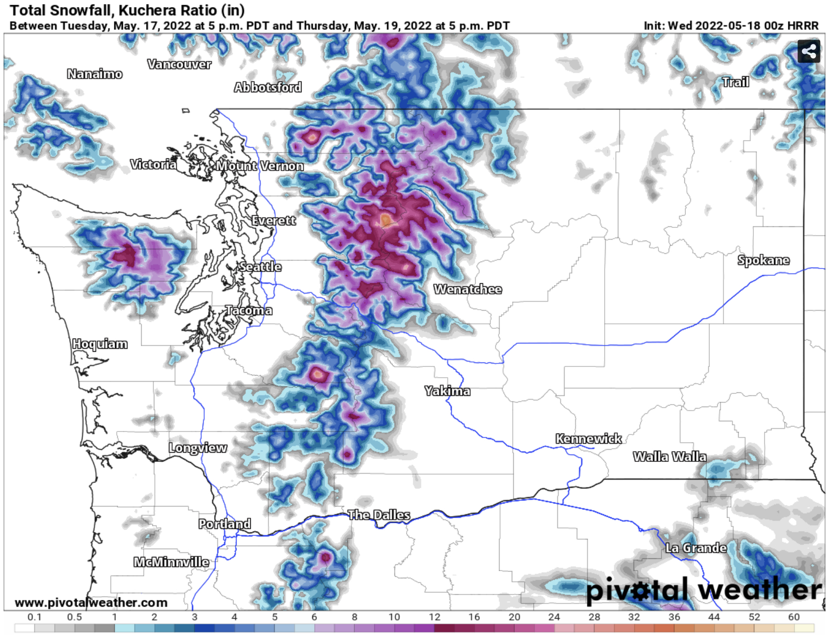
This storm will also bring mountain snow, both on Wednesday and in Convergence Zone bands on Thursday. The HRRR forecast for snow through Thursday evening is below.


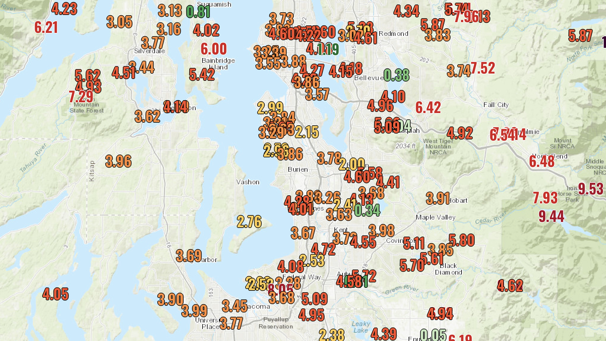
Although it is quite rare, it will snow at the passes in mid-May. The snow level will drop to near 3,000 feet by Thursday evening, and most passes will receive 4-6 inches of snow, with the most expected at Stevens. This snow is not enough to cause major impacts, but rapidly lowering snow levels with heavy snow in Convergence Zone bands can temporarily worsen road conditions, even at this time of year. Higher elevations will receive 1-3 feet of snow, adding to our already above average snowpack.

Lowland rain with this system will not be that impressive. The HRRR forecast for rain through Thursday evening is below.


Generally, expect 0.1-0.4 inches in the lowlands, potentially more under Convergence Zone bands on Thursday. Areas south of Olympia and on the coast will receive 0.5-1 inch, with the most in the Olympic Mountains (1-3 inches).

In short, a storm reminiscent of winter or early spring will impact Western Washington on Wednesday. The main impact for the lowlands will be abnormally gusty winds, potentially near or above 40 mph at their peak on Wednesday morning.

Stay tuned for details about the warm (upper 60s to low 70s) and sunny weather possible this weekend!

Saturday, May 14, 2022

Rainy Saturday & A Chance of Severe Thunderstorms for the Inland NW

 Update 10:00 AM Sunday: The Inland NW severe thunderstorm risk has been upgraded to “slight”, the 2nd of 5 categories. There is a 2% chance of tornadoes in the yellow area, and the entire dark green and yellow areas have a 5% chance of severe wind (58+ mph) and severe hail (1+” diameter). The best chance for severe thunderstorms will be in the afternoon to evening, mainly over the Blue Mountains.


————————————————————

FastCast—Sunday, May 15 to Thursday, May 19: 

After a warm and breezy day on Saturday, with partly sunny skies and highs in the mid to upper 60s, another round of rain is ahead. Expect 0.25 to 0.5 inches across the Lowlands and 0.5-2 inches on the coast and in the mountains. Highs will be in the upper 50s to low 60s, with lows in the upper 40s to low 50s. Expect partly to mostly cloudy conditions on Monday and Tuesday, with highs in the upper 50s to low 60s, and lows in the low to mid 40s. The next round of rain arrives Wednesday, with showers continuing into Thursday morning. Highs Wednesday and Thursday will be in the mid to upper 50s, with lows in the low to mid 40s. On Sunday, there is a chance of severe thunderstorms around the Inland Northwest. Take a look below for more information!

———————————————————

Continue reading the full blog below!

Another round of rain is heading for the Pacific Northwest. This system will also generate instability in the Inland Northwest, bringing a chance of severe thunderstorms, according to the NWS Storm Prediction Center’s outlook, seen below.


The dark green shaded area has a marginal risk of severe thunderstorms, including a chance of severe wind (58+ mph) and severe hail (1+” in diameter). 

The NWS Spokane graphic below shows some of the hazards to expect and what time thunderstorms are most likely.


The UW model below is showing CAPE (Convective Available Potential Energy), or instability in the atmosphere, around 7 PM Sunday.


CAPE values will reach 600-1000 over parts of SE Washington, NE Oregon, and Western Idaho. These values are conducive to thunderstorm development. 

Two other aspects of thunderstorm development are temperatures and dewpoints. With highs in the mid 70s to low 80s and dewpoints in the 50s, both are conducive to thunderstorms.

Meanwhile, no thunderstorms are expected on the west side of the Cascades, but another round of rain is on the way. The HRRR model below shows expected rain totals through Monday.


Expect 0.3 to 0.5 inches around the lowlands, with 0.5-1 inch on the coast. The Olympics and Cascades will receive 1-2 inches.

Wednesday, May 11, 2022

Another Significant Round of Spring Rain Ahead

 FastCast—Thursday, May 12 to Sunday, May 15:

After a few nice days, with highs in the upper 50s to low 60s, another round of spring rain is ahead, continuing the abnormal pattern that has brought above normal rain to the Northwest this month. Rain is moving onshore Wednesday evening, and a rainy day is expected on Thursday. Expect a break on Friday, with a chance of scattered showers. Rain will return on the weekend, with predominantly rainy conditions on Saturday and Sunday. Totals from Wednesday to Sunday will likely be 0.5 to 1 inch in the lowlands, 1-2 inches in the foothills and Cascades north of Mt. Rainier, and 2-3.5 inches on the coast and in the Olympics and South Cascades. Thursday’s temperatures will be over 10 degrees below normal, with lowland highs topping out in the low 50s. Temperatures increase through the weekend, with highs expected to be in the upper 50s to low 60s, despite the rain. Expect lows in the 40s, except in the upper 40s to low 50s on Saturday night. Some mountain snow is possible as well, mainly on Wednesday and Thursday, when snow levels are lower. The most snow (12-18”) will fall above 6,000 feet in the Cascades and Olympics. Only light amounts will fall at the Passes.

—————————————————————

Continue reading the full blog below!

The abnormally wet May pattern continues in the Pacific Northwest, with more systems ahead to end the week, continuing through the weekend.

The European model below shows rain through Sunday morning.


This will be another significant round of rain, with the lowlands receiving 0.5 to 1 inch of rain, with 1-2 inches in the Cascades and 2-3.5 inches of rain on the coast and in the Olympics. 

Another significant abnormality is the continued mountain snow. Light snow will fall at the Passes, with significant snow at higher elevations, with 12-18 inches above 6,000 feet, as seen below in the European model.


Thursday will be a significantly below average day, with high temperatures in the lowlands only in the low 50s, seen in the NAM model below.


This next image shows the temperature departure from average on Thursday, from the European model.


These are significantly below average temperatures, likely 10-15 degrees below average for the lowlands, more on par for late February or early March.

Remember the plus side…an increased snowpack and wetter spring will delay wildfire season and increase the summer water supply.


Monday, May 9, 2022

Wet and Cold Start to May Continues

 FastCast—Tuesday, May 10 to Friday, May 13:

May has been wet and chilly so far. Rain totals have been well above normal for most of Western Washington, with SeaTac Airport recording 1.94” as of Sunday, above the monthly normal of 1.88”. Rain will continue, along with below average temperatures. However, there will be a short break, with partly cloudy conditions and highs in the upper 50s to low 60s on Tuesday and Wednesday. Rain returns again late Wednesday, with a cold and rainy day expected on Thursday. Highs on Thursday will only reach the upper 40s to low 50s. Showers are possible, but not likely on Friday, with highs rebounding into the upper 50s and mostly cloudy conditions. Rain totals through Friday will be 0.4 to 1.25 inches in the lowlands, with the most in the foothills and around Everett. The coast and mountains will receive 1-3 inches. Expect lows in the entire period to be chilly, in the low to mid 40s, about 5 degrees below normal. There will also be some light snow at the passes, and mountain snow will continue at 6,000+ feet.

————————————————————

Continue reading the full blog below!

What an interesting month so far…May’s rain has already gone above average, and all but one day has had temperatures below average. These trends will continue. As average temperatures increase into the mid 60s, our temperatures have been stubborn, having a very hard time getting above 60 degrees. 

Let’s start with the rain that is coming up. The European model below shows rain through Friday morning.


Expect most of this rain to fall from late Wednesday through Thursday night. The lowlands pick up 0.4-1.25 inches, with the most in the foothills and near Everett. The coast and mountains will receive 1-3 inches. Some locations in the lowlands could have monthly totals up to 3 inches by the end of the week!

Some mountain snow will continue as well, with light amounts (non-impactful) at the Passes, and more (6-12 inches) above 6,000 feet. See the European model below for snow through Friday morning.


Regarding temperatures, expect them to remain below average for the foreseeable future. The European model below shows Thursday’s high temperature departure from average. The entirety of Washington and Oregon are below average.


Thursday’s highs in the lowlands will be in the upper 40s to low 50s, up to 5-15 degrees below average. That same trend is reflected around the Pacific Northwest.

The NWS Climate Prediction Center maps for temperature and precipitation (valid May 15-19) show that the Pacific Northwest will most likely continue having below average temperatures and above average precipitation through the middle of the month.


While this may be dismal to some, the positive side is that the snowpack continues to build, our water supply is still increasing, and water worries this summer are virtually guaranteed to not happen. 

Friday, May 6, 2022

Mountain Snow on Mother’s Day Weekend as Abnormal Weather Continues

 FastCast—Saturday, May 7 to Wednesday, May 11:

An abnormal (much wetter than normal) pattern has brought a couple rainy days to Western Washington, with showers expected to continue at times from Friday night to Sunday night, with a break from midday Saturday until midday Sunday. Breezy conditions, with winds gusting 25-35 mph, are expected on Saturday. Convergence Zone activity is possible on Saturday afternoon around the Everett area. Rain totals through Sunday evening will be highly dependent on showers that move over your area. Generally, expect and additional 0.3-0.5 inches, with up to 0.75-1.25” under the Convergence Zone or heavier showers. Mountain snow is also expected, with up to 10 inches at higher passes, and up to 4 inches at Snoqualmie Pass. The snow level will hover around 3,000 feet this weekend. An interesting and noticeable weather impact this weekend will be the much below average temperatures that are expected. Highs through Monday will be in the mid 50s, nearly 10 degrees below average. Lows will also be below average, likely in the low 40s, 5-10 degrees below average. High temperatures will increase to the upper 50s on Tuesday and Wednesday, and drier weather is expected.

——————————————————

Continue reading the full blog below!

This May has felt more like an extension of March, with temperatures in the 50s and showery conditions, including mountain snow. That trend will continue this weekend. 

Below is the HRRR forecast for rain from Friday evening to Sunday evening.


Some of this has already fallen as of the writing of this blog. However, expect an additional 0.3-0.5 inches across Western Washington, with totals of 0.8 to 1.25 inches under the Convergence Zone (near Everett) or in stronger showers. 

The rain should mostly end by midday Saturday, with a slight chance of showers late Sunday and late Monday…but much less rain than the past few days. 

Expect breezy conditions on Saturday, mainly south of Seattle and along the Strait of Juan de Fuca. Gusts will be 25-35 mph, except up to 40 mph along the Strait.

In a rare twist for May, it will snow at the Passes this weekend. The snow level will be all the way down to 3,000 feet. The HRRR forecast below shows snow through Sunday evening.


This is quite a snow map for May! Expect 1-4 inches of snow at Snoqualmie Pass and up to 10 inches at the higher passes. The snow level will hover around 3,000 feet, very low for May. Snow will even fall in the Coast Range of Oregon and the Blue Mountains of SE WA and NE OR. Higher elevations in the Cascades will receive upwards of 1-2 feet of snow (3+ feet at the mountain peaks)!

This will be quite the contrast for the Blue Mountains, which had severe thunderstorms Friday evening!

In addition to showers and mountain snow, temperatures of 10-30 degrees below average will continue across the entire Pacific Northwest, as seen in the European model forecast for 5 PM Saturday.


Western Washington is not alone in the not-May-like temperatures. The entirety of Washington, Oregon, Idaho, and Western Montana are all experiencing temperatures 5-15 degrees below average. One of the most stunning parts of this map is the below average temperatures in the Cascades. Temperatures this weekend will be up to 20-30 degrees below average, explaining some of the weekend snow.

There is good news…as some forecasts show warmer temperatures returning by mid-May!

Wednesday, May 4, 2022

Wet & Active Pattern Ahead, Colder Temperatures Expected

 FastCast—Thursday, May 5 to Monday, May 9:

After a couple days of mostly dry weather (and highs in the mid to upper 60s on Wednesday), a much wetter few days are ahead for Western Washington. Rain will begin late Thursday night/early Friday morning. Expect rain to continue from then until  late Friday/early Saturday. Some brief breaks are possible, and the most rain will fall on Thursday and Friday, with mainly scattered showers and a slight chance of thunderstorms on Saturday. Generally, expect 0.75 to 1.5 inches of rain around the lowlands (highest in the foothills) through Sunday. In the mountains and on the coast, expect 2-4 inches of rain. Eastern Washington will get some much-needed rain, totaling 0.5 to 1.75 inches, except 0.1 to 0.4 inches in the Grand Coulee area. Breezy conditions (gusts 30-35 mph) are expected at times on Thursday evening into the night and on Saturday, especially in the afternoon and evening. 2-4 inches of snow are possible at the Passes through Sunday. Expect little to no impact. This pattern will also be much cooler than normal. Highs will only reach the low 50s through Sunday, with lows in the upper 30s to mid 40s. 

————————————————————

Continue reading the full blog below!

A pattern more reminiscent of March or April is ahead for Western Washington. It will be quite a contrast from the nice (albeit mostly cloudy) day on Wednesday, which saw highs reach the mid to upper 60s around Western Washington, and into the mid to upper 70s in Eastern Washington.

Rain is moving onshore as of Wednesday evening, and will begin across the region overnight. Below is the European model forecast for rain through 5 AM Sunday.


This will be quite a rainy pattern for May. Expect 0.75-1.5 inches of rain around the lowlands, with the highest totals in the foothills. The coast and mountains will receive 2-4 inches, and Eastern Washington will receive 0.5-1.5 inches, except less in the rain-shadowed North-Central section. Southwest Washington and the Willamette Valley will receive 1.5-2 inches as well.

2-4 non-impactful inches of snow are possible at the passes during this wetter pattern, as well. Higher elevations in the Cascades (5,000-6,000+ feet) will receive 1-3 feet, significant for May! The European model for snow accumulations through 5 AM Sunday is below.

Breezy conditions are possible Thursday evening (30-35 mph) and on Saturday. Saturday is a bit more interesting, with a potential for a Convergence Zone over the Everett area. This may bring winds gusting up to 35-40 mph for areas between South Seattle and Olympia. Stay tuned for more information about wind.

This pattern will also bring temperatures that are significantly cooler than average. The European model graphic below shows the temperature departure from average at 5 PM Saturday.


The entire Pacific Northwest is 5-15 degrees below normal, up to 20-25 degrees below normal in the mountains.

This is reflected in the NWS Climate Prediction Center 6-10 day outlook for temperature departure from average, valid May 10-14.


Most of the Western United States has a 50+ percent chance of below average temperatures, while it is a much different story east of the Rockies.

Seattle’s average highs for early May are 63-64°, but highs from Thursday to Sunday will only reach the 50-54° range, nearly 10-15 degrees below average. 

All of this is not uncommon for a La NiƱa year, but this spring stands in stark contrast to last spring, when there had already been 90+ wildfires in Washington by April. Due to persistent below average temperatures and rain, that is not the case so far!

Sunday, May 1, 2022

Active Start to May Expected

FastCast—Monday, May 2 to Saturday, May 7:
A wet start to May is ahead for Western Washington. Sunday was a nice day, with highs in the low to mid 60s. Rain returns late Sunday night, continuing through midday Monday. Expect 0.2 to 0.5 inches of rain around the region. Drier and cloudy weather is expected on Tuesday and Wednesday. Highs will be in the mid to upper 50s on Monday and Tuesday, and in the mid to upper 60s on Wednesday. Rain returns again very late Wednesday night or early Thursday morning, continuing at times through Saturday evening. This will be a much wetter period (especially Friday), with a total of 1 to 1.75 inches of rain in the lowlands, 1.5 to 4 inches on the coast and in the mountains, and 0.5 to 0.8 inches in Eastern Washington. Breezy weather is also possible on Saturday. Highs from Thursday to Saturday will be in the mid to upper 50s, with lows in the entire period (Monday to Saturday) in the 40s.

———————————————————
Continue reading the full blog below!

All four months of 2022 have had above normal rainfall in Western Washington, and it appears that May will follow that trend. May’s average rainfall at Sea-Tac Airport is around 1.9 inches, and even more than that could fall this week alone! Let’s take a look at what’s ahead.

Below is the HRRR model forecast for rain through 11 PM Monday, in the first (weak) system moving through overnight Sunday into Monday.


Rain with this system will be modest, with 0.2 to 0.4 inches around the lowlands (possibly higher in some places). The mountains will receive the most rain, with up to 1.25 inches south of Snoqualmie Pass.

A nice break in the rain (though it will still be cloudy) is expected on Tuesday and Wednesday. As seen in the European model below, a brief ridge (red colors) will build over the area on Wednesday.


This ridge will bring some warmer temperatures on Wednesday (though it may feel “muggy” since it’s on the cloudy side). Expect highs on Wednesday to reach the mid to upper 60s in the lowlands and the low to mid 70s in Eastern Washington.

However, the dry weather won’t last for long. Rain returns on Thursday as troughing re-establishes itself over the Pacific Northwest. This means that a steady stream of weather can move in, bringing lots of rain. Take a look at the difference between the model above (Wednesday) and the model below (next Saturday).


This is a total shift from Wednesday, with significant troughing established by Saturday. This troughing will help bring systems from Thursday into the weekend.

The European model below shows total rain through Saturday evening (including the rain on Monday).


From Thursday to Sunday, expect 1-1.75 inches of rain in the lowlands, 1.5 to 4 inches in the mountains/on the coast, and 0.4 to 0.8 inches in Eastern Washington.

Notice that totals in the lowlands are between 1.5 and 2 inches for the first 7 days of May. This means that it’s possible that we will receive over 75% of this month’s average rainfall in one week!

There is also a chance of some Convergence Zone activity and breezy conditions on Saturday.

Stay tuned…although it is spring, the active weather hasn’t gone away!

————————————————
The Pacific Northwest Weather Workshop (the annual conference about Pacific Northwest weather) is on Zoom from 8:45 AM to 12:30 PM on May 7th, and it is free!

Short Spring Heat Wave for the Pacific Northwest

  FastCast--Thursday, May 9 to Tuesday, May 14: A spring "heat wave" is ahead for the Northwest, with the warmest temperatures see...