FastCast—Thursday, May 5 to Monday, May 9:
After a couple days of mostly dry weather (and highs in the mid to upper 60s on Wednesday), a much wetter few days are ahead for Western Washington. Rain will begin late Thursday night/early Friday morning. Expect rain to continue from then until late Friday/early Saturday. Some brief breaks are possible, and the most rain will fall on Thursday and Friday, with mainly scattered showers and a slight chance of thunderstorms on Saturday. Generally, expect 0.75 to 1.5 inches of rain around the lowlands (highest in the foothills) through Sunday. In the mountains and on the coast, expect 2-4 inches of rain. Eastern Washington will get some much-needed rain, totaling 0.5 to 1.75 inches, except 0.1 to 0.4 inches in the Grand Coulee area. Breezy conditions (gusts 30-35 mph) are expected at times on Thursday evening into the night and on Saturday, especially in the afternoon and evening. 2-4 inches of snow are possible at the Passes through Sunday. Expect little to no impact. This pattern will also be much cooler than normal. Highs will only reach the low 50s through Sunday, with lows in the upper 30s to mid 40s.
————————————————————
Continue reading the full blog below!
A pattern more reminiscent of March or April is ahead for Western Washington. It will be quite a contrast from the nice (albeit mostly cloudy) day on Wednesday, which saw highs reach the mid to upper 60s around Western Washington, and into the mid to upper 70s in Eastern Washington.
Rain is moving onshore as of Wednesday evening, and will begin across the region overnight. Below is the European model forecast for rain through 5 AM Sunday.
This will be quite a rainy pattern for May. Expect 0.75-1.5 inches of rain around the lowlands, with the highest totals in the foothills. The coast and mountains will receive 2-4 inches, and Eastern Washington will receive 0.5-1.5 inches, except less in the rain-shadowed North-Central section. Southwest Washington and the Willamette Valley will receive 1.5-2 inches as well.
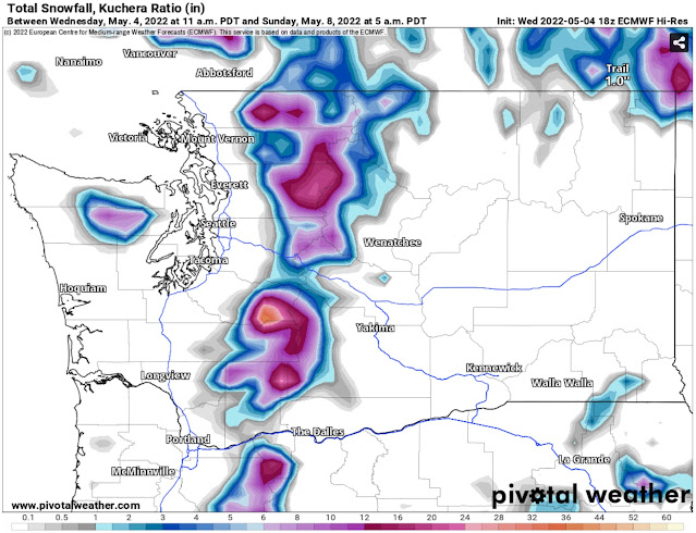
2-4 non-impactful inches of snow are possible at the passes during this wetter pattern, as well. Higher elevations in the Cascades (5,000-6,000+ feet) will receive 1-3 feet, significant for May! The European model for snow accumulations through 5 AM Sunday is below.
Breezy conditions are possible Thursday evening (30-35 mph) and on Saturday. Saturday is a bit more interesting, with a potential for a Convergence Zone over the Everett area. This may bring winds gusting up to 35-40 mph for areas between South Seattle and Olympia. Stay tuned for more information about wind.
This pattern will also bring temperatures that are significantly cooler than average. The European model graphic below shows the temperature departure from average at 5 PM Saturday.
This is reflected in the NWS Climate Prediction Center 6-10 day outlook for temperature departure from average, valid May 10-14.
Most of the Western United States has a 50+ percent chance of below average temperatures, while it is a much different story east of the Rockies.
Seattle’s average highs for early May are 63-64°, but highs from Thursday to Sunday will only reach the 50-54° range, nearly 10-15 degrees below average.
All of this is not uncommon for a La Niña year, but this spring stands in stark contrast to last spring, when there had already been 90+ wildfires in Washington by April. Due to persistent below average temperatures and rain, that is not the case so far!


No comments:
Post a Comment