FastCast—Friday, May 20 to Wednesday, May 25:
It has been a spring of abnormalities. After a spring windstorm brought gusts of 30-40 mph in the lowlands and 45-55 mph in more wind-prone areas on Wednesday, a big change is ahead. A ridge will build over the Pacific Northwest this weekend and into next week, ending the troughing pattern that has brought many cool and rainy days this month. This ridge will bring a mostly sunny and warm weekend, with highs in Western Washington reaching the upper 60s to low 70s! Clouds increase on Monday, with partly to mostly cloudy conditions through Wednesday. However, temperatures near average will continue, with highs in the mid 60s to low 70s. Lows will be in the low to mid 40s on Friday and Saturday, then will increase to the upper 40s to low 50s through Wednesday. Additionally, besides a slight chance of showers on Friday and Saturday, expect dry conditions along with the warmth! Stay tuned over the next few days as details become more clear regarding even warmer temperatures.
—————————————————————
Continue reading the full blog below!
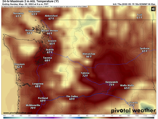
After a cold and rainy month, with temperatures up to 15 degrees below average at times, warmer weather is finally in the forecast! The high temperature forecast for Sunday (from the European model) shows our long-overdue warmth.
This is a sight for sore eyes for many around Western Washington! Expect highs in the upper 60s to low 70s across Western Washington on Sunday. (Similar conditions are expected on Saturday, but highs will be slightly cooler, in the mid to upper 60s). There is a chance of showers on Friday and Saturday, but any showers should be short-lived.
Why is this warmup finally happening? The troughing pattern that has dominated recently (persistent low pressure, bringing weather systems) is being replaced by a high pressure ridge. This ridge will build throughout the weekend and peak in the middle of next week. The European model below shows the ridge at maximum strength next Wednesday.
While this ridge will not prevent cloudy conditions next week, it will bring consistent highs in the mid 60s to low 70s for Western Washington.
Now for the interesting side of this pattern…forecasts are showing a potential for very warm conditions across the state next Wednesday and Thursday. Around this time, the ridge will be pulling out as troughing, cooler temperatures, and showers begin moving back in. The European and GFS models are showing the potential for highs in the mid to upper 70s in Western Washington and the low 80s to mid 90s in Eastern Washington. (See the European model forecast for highs next Thursday).
Note that highs for Everett, Seattle, and Tacoma are a few degrees lower than surrounding areas further from the water. Most of the metro area would reach the upper 70s in this forecast. Temperatures in Eastern Washington would be in the low 80s in the north to mid 90s in the Columbia Basin. SW Washington and the Willamette Valley could reach the low 80s to near 90 in this forecast.
Bottom line: Warmer spring weather has arrived in Washington! This weekend and the beginning of next week will have highs in the mid 60s to low 70s in Western Washingon. Uncertainty remains about next Wednesday and Thursday, particularly how warm temperatures will be, so stay tuned!


No comments:
Post a Comment