An interesting mix of weather is ahead for Western Washington. Expect mostly dry and warm conditions on Wednesday and most of Thursday. While conditions will be mostly cloudy, highs will be in the mid to upper 60s around the Puget Sound area. Rain will arrive late Thursday, continuing through early Friday. A break in the rain is expected on Friday. Showers arrive again early on Saturday, continuing through Sunday night. The rainfall totals from Thursday to Sunday will be 0.5-1.25 inches, with the most in the foothills and north of Everett, and less in rain-shadowed areas near the eastern slopes of the Olympics. Temperatures will drop significantly on Friday, Saturday, and Sunday. Expect highs to only reach the upper 50s to low 60s, nearly 10 degrees below average. However, a big warmup is ahead, starting on Memorial Day, when highs will rebound into the mid-upper 60s. Starting on Tuesday, highs will increase into the low 70s. More days in the 70s are expected to start June!
———————————————————
Continue reading the full blog below!
Before the wet weekend that is ahead, warm (near average) weather is expected around Washington state. The NAM model forecast for high temperatures on Thursday is below.
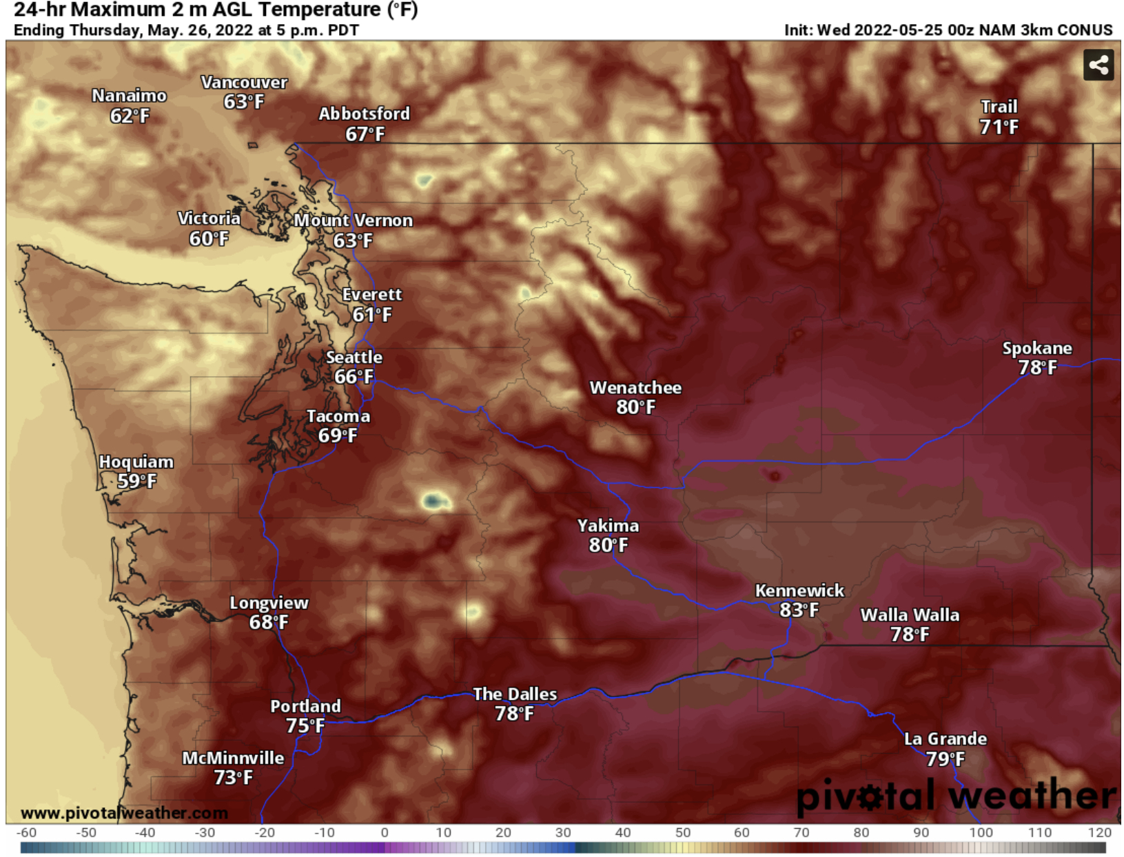
Expect similar temperatures on Wednesday…in the mid to upper 60s in the lowlands, the upper 70s to mid 80s in Eastern Washington, and the upper 60s to mid 70s in SW WA and the Willamette Valley. It isn’t out of the question that some lowland locations may reach 70 degrees on Wednesday and Thursday.
Rain will arrive late Thursday, continuing through Friday morning. A break is expected on Friday, with a longer and more significant round of rain on Saturday and Sunday. Totals through the holiday weekend are below (from the European model).

Expect 0.5-1.25 inches of rain around the lowlands. The most will fall in the foothills and north of Everett. The coast will receive 0.6 to 1.5 inches, and the mountains will be soaked with 1.5-3 inches. Even Eastern Washington will pick up 0.2-1.2 inches. SW WA and the Willamette Valley will receive 0.75-1.5 inches.
Now for the best news…the big warmup that starts Memorial Day! Expect highs to reach the mid to upper 60s on Monday, then the low 70s on Tuesday. Temperatures will likely continue to increase through the week. Highs on Thursday, June 2nd are below (European model forecast).

This forecast shows highs in the mid 70s in the Puget Sound area! Stay tuned for more information about the upcoming warmth!

No comments:
Post a Comment