Saturday, October 31, 2020

Incredibly Devastating Super Typhoon Goni

While Western Washington experiences a few days of calm weather, the strongest tropical cyclone at landfall in recorded history is impacting the Philippines.

Super Typhoon Goni made landfall near Legazpi in the east central Philippines, with sustained winds of 195 mph, gusting to 230 mph. Below are 2 satellite images of the typhoon.


Goni is also the strongest storm of 2020. It is likely that this storm will cause widespread devastation in the impacted regions of the Philippines. 

Super Typhoon Goni is the preliminary record holder for the strongest storm at landfall in recorded history. It breaks the record set by Super Typhoon Haiyan in 2013, which made landfall in the Philippines at 190 mph. A humanitarian crisis followed Haiyan's impacts, and a similar crisis is likely after Goni as well.

Please pray for those impacted by Super Typhoon Goni. The Philippines is a country that is prone to strong typhoons, and the impacts can last for years.

Thursday, October 29, 2020

Breezy With Spotty Rain on Friday

Friday will be breezy, with wind gusts 25-40 mph across the area. Some light rain will also be possible, but due to westerly flow, most of Puget Sound will be “rainshadowed” bringing lesser rain accumulation.

Below is the Euro model forecast for Friday in Puyallup.


Expect some light rain in the morning, followed by winds gusting 25-40 mph from mid morning to late afternoon. A system moving into Northern Vancouver Island will bring pressure change to its south (causing winds here).

Below is the UW forecast precipitation.


Expect 0.0-0.15 inches of rain on Friday. Most of the rain will fall in the morning.

As Friday winds down, expect partly-mostly clear/sunny conditions through Monday night. Highs will be 50-60 degrees, with lows 37-45 degrees.

By the time we get to Tuesday, expect a more active weather pattern to begin. I’ll have details soon!

Sunday, October 25, 2020

Chilly Conditions & Local Weather Features

Sunday morning was chilly across the South Sound region. Recorded low temperatures were in the mid 20s-mid 30s.


Notice that the coldest temperatures were observed in outlying areas, but also take note of warmer temperatures in the areas downstream of Enumclaw. We’ll get back to that later.

Sunday night-Monday morning will be cold as well. A Frost Advisory is in effect from 2-10 AM Monday, and is posted below.


Frost will form with cold temperatures overnight, potentially killing sensitive plants. Be careful on your morning commute, as patchy black ice is possible.

Temperatures will warm up a bit through the week, with highs of 50-62 degrees and lows of 35-49 degrees. Here’s a graphic from NWS Seattle.


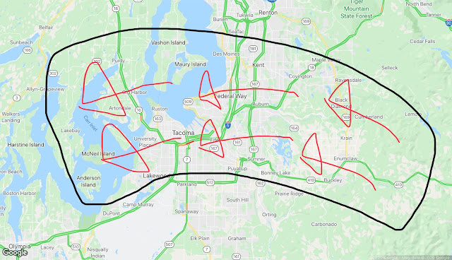
Back to the localized warmer temperatures I mentioned earlier. Remember back in September, when strong winds gusted out of the Cascade gaps? Those winds impact the areas circled below.


Well, the same thing happened last night, just to a much lesser extent. Take a look at the peak wind gusts on Sunday.


Winds gusted 20-30 mph. Compare the circled areas in both graphics...they are nearly the same. You might be wondering why this happened. 

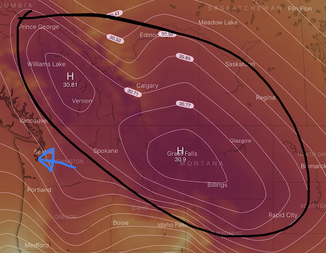
A massive high pressure ridge (black outline) has been moving down from Arctic Canada. This ridge accelerated winds through the gaps in the Cascades (blue arrow).


If it felt drier this morning in areas impacted by the winds, it was. Below is the minimum relative humidity on Sunday.


Notice very dry conditions with 29-35% humidity in parts of Puyallup, Auburn, Edgewood/Milton, and Federal Way.

Sunday night will have calmer winds, and areas that were impacted by the winds will likely cool more tonight, with frost likely.

It’s fun to see local “microclimates” in action!

Friday, October 23, 2020

First Freeze, Taste of Winter for Western Washington

A weather system moved NW-SE through Western Washington today, bringing occasional rain and winds gusting 15-30 mph. This system also brought snow to the Cascades, and 6 inches to Spokane! Wow!

Behind this system, cold northerly winds (coming from the north) will blow into Western Washington from Canada. 

Here’s the 9:30 PM Friday temperatures.


Temperatures will be slow to cool through the night, with lows reaching the upper 30s-mid 40s. Friday night will be the warmest night until Tuesday night.

Expansive high pressure moving into the Western United States will bring sunny and cold weather to our area this weekend.

Freeze Watch is in effect for the Lowlands from 2-10 AM Sunday. Click the alert name or view it below.


Bottom line: low temperatures of 27-32 degrees likely Sunday morning, ending the growing season, and bringing a chance of black ice on untreated roads.

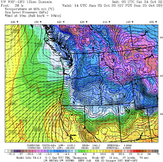
Below is the UW forecast for 7 AM Sunday. Cold in Western Washington, colder in eastern parts of Washington, Oregon, and Idaho, and downright frigid in Montana and Wyoming.


In addition to freezing temperatures, winds will gust 20-40 mph from the north this weekend. This will create wind chills of 15-35 degrees. Brrrr! Below is a wind chill chart from the NWS. (Temperature on top, wind on the left.)


Here is a graphic from NWS Seattle showing expected low temperatures Sunday & Monday nights. (Click to enlarge).


It won’t just be cold during the night and in the mornings...daytime highs will only reach 45-53 degrees from Saturday-Tuesday.

Wednesday, October 21, 2020

Colder Weather Impacting Western Washington

Colder weather is now impacting Western Washington. Here’s a look at current (8:40 PM Monday) temperatures around the region.


Temperatures are already cooling into the low 40s in the lowlands and upper 30s in the foothills.

A Frost Advisory is in effect for potential frost and near freezing temperatures from 11 PM-8 AM (Wednesday into Thursday). The advisory is in effect for the blue shaded area (approximately Bonney Lake eastward).


Even if you don’t live inside the advisory area, patchy frost is likely in some places.

Thursday morning will be the coldest morning since early May, with lows of 35-40 degrees in the South Sound.

Below is an event timeline for the next few days from NWS Seattle. (Click to enlarge)

A few days of cold weather are likely, but before the cold+dry weather arrives, a system will move by on Friday.

This system will drop snow levels to 2,000 feet, bringing accumulations on the passes and 0.05-0.3 inches of rain in the lowlands. Most of the rain will be on Friday.

Here’s the UW model forecast for rain through 5 AM Saturday. Our area is in the “rain shadow” when northwesterly flow is blocked by the Olympic Mountains, therefore lessening the Puget Sound precipitation totals.


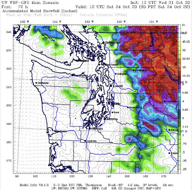
Below is the forecast snow through 5 AM Saturday.


Wow. Lots of snow in the Cascades. 3-16 inches, with the most at higher elevations. There is a possibility of light snow north of Bellingham, and a slight chance of rain/snow mix above 700 feet.

After the system passes on Saturday morning, temperatures will be quite cold. Highs in Western Washington will be 40-50 degrees, with lows of 28-38 degrees, from Saturday to Tuesday. Expect the first widespread freeze & frost by Sunday morning.

In the mountains and Eastern Washington, lows will drop to 5-20 degrees...that makes you cold just thinking about it.

Stay tuned! I will have updates by Friday regarding the upcoming weather!

Monday, October 19, 2020

Much Cooler Weather, First Frost of the Season Likely by the Weekend

Much cooler weather is heading for Western Washington. It will be a major transition from the breezy, 55-65 degree weather that has dominated the past few days.


The outlook above is from NWS Seattle, showing expected weather for the week.

The biggest weather story is the transition to cooler weather. The low temperatures on Monday will be near the high temperatures on Friday and Saturday.

Take a look at the weather.com 10 day forecast for Puyallup.

There is a steady decline in temperatures all week, bottoming out with highs struggling to reach 50 degrees and lows near/below freezing on the weekend. Our first frost of the season is likely during the next week, with multiple frosty mornings likely. 

This means the end of the growing season. In addition, the first mountain snow of the season is likely at the end of the week and into the weekend. Below is the first snow map of the season in the blog...showing expected accumulations through the next 7 days.

Snow levels will be around 3,000 feet, so light accumulations on the passes are possible. Expect 2-10 inches of snow in the mountains, with 1-4 inches possible in parts of Eastern Washington. 

No snow likely in the Puget Sound area right now. 

Bottom line...expect a transition to colder weather through this week, with freezing temperatures and frost likely by the weekend.

Thursday, October 15, 2020

Breezy On Friday, Slow Cooling Trend Likely

Another breezy day is likely on Friday. Expect wind gusts of 20-35 mph, with the breeziest conditions from late morning through the evening. 

Here is a weekend outlook from NWS Seattle


Classic fall weather for Western Washington. Here’s the UW forecast model, showing rain from Friday afternoon to Sunday afternoon.


Expect 0.05-0.3 inches of rain through these next few days, with more rain on the coast, in the mountains, and Everett northward. You can see the “rain shadow” effect that northwesterly flow has on the Puget Sound area...less rain on the leeward or sheltered side of the Olympics is evident in the forecast model image.

In the 10 day forecast from weather.com for Puyallup, you can see the temperatures hovering in the 50s-low 60s, with morning lows in the 40s-low 50s. Normal temperatures for fall. (Chance of rain is the percentage on the right).


Enjoy the relatively calm weather and our fall foliage around Western Washington!

Wednesday, October 14, 2020

Recent Weather Recap & A Look Ahead

What an active last few days! We have had strong winds, heavy rain, power outages, and even thunderstorms! 

Here are peak wind gusts from Tuesday. Widespread gusts of 30-50 mph were observed across the area. Forecast models & the NWS nailed this event.


In addition to these strong winds, over 100,000 people in Western Washington lost power on Tuesday. 

This high number of power outages is because this was the first storm of the season, and trees had lots of leaves...many of which are gone now. 

We also had a lot of rain over the weekend and early in the week. Here are rain totals from Friday to Wednesday night.

1.5-3 inches fell across the South Sound area. October totals are now in the 1.5-3.5 inch range. Add this to our end of September rain, and we have received 4-7 inches in the past month!

Now a look ahead...

We are under a big high pressure ridge. This ridge will bring a dry day with morning fog on Thursday. Morning lows will be cool...likely in the 40s. 

A chance of rain returns on Friday, with mostly cloudy conditions and chances of rain for the next few days after that. 

Here is the 10-day forecast for Puyallup from weather.com.


Near or slightly below normal temperatures for the foreseeable future. Enjoy the relatively “calm” weather!

Monday, October 12, 2020

Rainy & Windy On Tuesday

Winds have calmed from Sunday/Monday's minor wind event, only to pick up again--likely stronger--than they were previously.

A Wind Advisory is in effect for the Puget Sound Lowlands from 12 PM-6 PM Tuesday. You can find the alert below or click here.


Here's the bottom line with this storm...expect winds of 20-30 mph with gusts of 40-50 mph across Puget Sound on Tuesday.

Let's take a look at the details of not only the winds, but also the last round of rain for the near future.

This wind graphic from NWS Seattle shows expected peak winds on Tuesday.


You can click on the image to zoom in and see the numbers. I also have a forecast below.

A moderately strong low pressure center will make landfall on central Vancouver Island on Tuesday. The pressure gradient (change) behind it will bring strong winds to Western Washington. Stronger pressure change=stronger winds. The closer the lines of pressure on the map, the stronger the winds will be. 

Strong winds are likely across the area on Tuesday due to this strong pressure change.

Let's talk timing. Winds will increase in the early morning hours, with winds gusting over 30 mph all day. Peak winds are expected to occur in the afternoon.

Here are the peak gust forecasts for cities around the region on Tuesday:

Puyallup/Sumner: 40-50 mph

South Hill: 40-50 mph

Graham:  35-45 mph

Bonney Lake: 35-50 mph

Tacoma/Fife: 40-50 mph

Lakewood: 40-50 mph

Federal Way:  40-50 mph

Auburn: 40-50 mph

As you can see...widespread wind gusts of 40-50 mph are likely. There is a small chance of winds above 50 mph, but that is most likely over the water. Winds will gradually subside through Tuesday night.

This graphic from NWS Seattle gives some good reminders for when winds are forecast.


Since this is the first windstorm of the season, expect localized power outages and tree damage.

In addition to the wind expected on Tuesday, we will also have 0.5-1.5 inches of rain through Wednesday morning. The bulk of the rain will be late Monday night into Tuesday morning.

Here's the UW model forecast showing precipitation through 5 AM Wednesday.


It is safe to expect between 0.5 and 2.5 inches of rain across the Lowlands with this system.

One impact of the combination of rain and wind is leaves and other debris clogging area storm drains, causing urban flooding and standing water. This NWS Seattle graphic outlines some hazards.


Stay safe out there! If you're not a storm fan...we're expecting some sun soon!

Sunday, October 11, 2020

Sunday Windstorm Update

As promised in the last blog, here is an update regarding the Sunday afternoon & evening windstorm.

A low pressure center will make landfall on southern Vancouver Island this evening. This low center has a strong pressure gradient (change over an area) to the south and west of it. And as we know...change in pressure causes winds. Therefore, the stronger the pressure change, the stronger the winds.


I have put a blue oval around the area of strongest pressure change. This map is for 2 AM Monday.

Let's talk timing and gusts. Winds will begin increasing around 2-4 PM. Peak winds are likely from 5 PM-2 AM. After that, winds will subside through midday Monday.

Here are likely peak gusts from 2 reliable forecast models (Euro & NAM) for local cities.

Puyallup/Sumner: 35-50 mph

South Hill: 35-50 mph

Graham: 35-50 mph

Bonney Lake: 35-50 mph

Tacoma/Fife: 35-50 mph

Lakewood: 35-50 mph

Federal Way: 35-50 mph

Auburn: 35-50 mph

CenturyLink Field (gametime 5:20 PM): 35-45 mph

Because this is the first strong storm of the season, expect localized power outages and tree damage. 

This storm will also bring rain. Expect 0.3-1.0 inches of rain across the South Sound through Monday morning. 

Another potentially windy weather system will be coming to the area on Tuesday. I'll have an update on Monday night regarding this next system.

Saturday, October 10, 2020

Windy & Rainy Weather Continues on Sunday

Expect an update midday Sunday regarding the threat of strong winds Sunday evening. For those following the blog by email--this update won't be delivered to your inbox until Monday morning, so be sure to check in!

Saturday has given us our first taste of fall! The day started with moderate to heavy rain, and from mid-morning to tonight, winds have been gusting 20-35 mph across the area! There has also been some scattered showers/thunderstorms from South Hill southward.

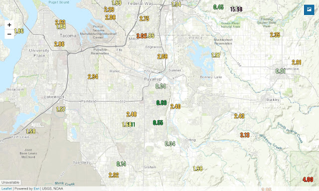
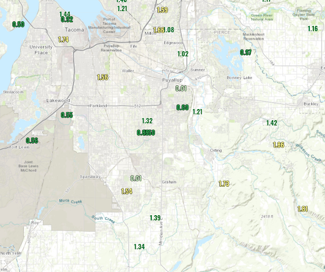
Here's the 24 hour rain totals (6 PM Fri. to 6 PM Sat.).


Widespread totals of 0.5-1.9 inches of rain!
Most of this rain fell between 9 PM Friday and 9 AM Saturday, as a cold front moved through during the early morning hours.

As the pressure rose after the frontal passage, winds increased in the South Sound, with gusts of 20-40 mph through the second half of the day. 

Temperatures are also much cooler. Lows in the 40s are likely from here on out.

Sunday will be another stormy fall day, mainly from noon onward. Let's take a look at the details.

Here is the Puyallup forecast from the Euro model for Sunday.


Sunday will bring another 0.4-1.5 inches of rain to the area, along with potentially the strongest winds of the season so far.

A low pressure center (just to the left of the NW tip of WA) will make landfall on our coast in the afternoon. 


Behind and to the south of this low center will be a strong pressure difference--causing gusty winds in the Puget Sound area.

Expect winds to pick up from 2-4 PM, with potentially strong winds from 4-11 PM. Forecast models indicate winds gusting 30-50 mph at the peak of the storm. With these winds, expect some power outages and tree damage. Winds will subside through Monday morning.

Let's take a look at precipitation moving forward. This forecast is for rain through 5 AM Monday.


It is safe to expect another 0.5-2.6 inches of rain. This will bring monthly totals over 2 inches, and possibly higher.

Don't worry...the action doesn't stop there. Another weather system with rain & wind is heading for us on Tuesday. It's fall in Western Washington!

Friday, October 9, 2020

Friday Night Update

Widespread rain is moving onshore and into Western Washington. Below is the 9:50 PM radar image from the WA Coast radar. The associated frontal system is pushing rain onshore.


Lots of rain will move onshore through the night and into the morning. Rounds of moderate to heavy rain along with possible gusty winds (25-40 mph) are likely though Friday night into Saturday morning. 

Here is the UW model forecast for rain through 5 PM Saturday.


It is a safe bet to expect 0.5-1.3 inches of rain through Saturday evening. 

There is also a chance of thunderstorms on Saturday. The air behind the previous frontal system will be unstable. Expect scattered showers with downpours and possible thunder/lightning and small hail. 

Here is Saturday's forecast from the Euro model for Puyallup. (Expect similar conditions across the South Sound).


Additional rain and winds gusting 20-40 mph are likely on Saturday.

I will have another update tomorrow regarding weather on Sunday and Monday.

Thursday, October 8, 2020

Active Fall Weather Coming To Western Washington

After a relatively calm start to October, active fall weather is in store. Starting Friday afternoon, multiple weather systems will impact our area through late Tuesday. Let's dive into the forecast!

Here is an overview of the Euro Model forecast. This forecast is for Puyallup, from Friday to Saturday.

To read the forecast, from top to bottom: Date, time, sky condition, temperature, rain (if any), sustained wind, wind gust, wind direction.

Friday will likely be breezy, with winds gusting 20-30 mph. Stronger winds (45+ mph) are likely at the coast and in the Bellingham area.

Rain will start between 4 and 10 PM Friday. Expect moderate to heavy rain Friday night through Saturday morning. Below is the UW model forecast for rain from Thursday-Saturday afternoon.


The green shading indicates 0.64-1.28 inches of rain. This is consistent with other predictions, so I would expect this amount of rain. This amount of rain is due to a frontal system moving through, bringing widespread rain to Western WA.

If we refer back to the Friday/Saturday forecast, we see winds gusting 25-40 mph on Saturday. Expect localized power outages and possible tree damage as the winds push out the frontal system.

Behind the front, there will be increased instability and a chance of thunderstorms. Here is the UW model forecast for instability (CAPE) at noon on Saturday.


CAPE is in the 200-600 range. This is more than normal for Western Washington, and it is safe to expect scattered showers with potential lighting/thunder, heavy rain, small hail, and gusty winds on Saturday. 

Moving on to Sunday...here is the Euro model forecast for Puyallup from Sunday to Tuesday night.


There's three things I want to draw your attention to. Those things are cooler temperatures (48-63 degrees), another 0.5-2.0 inches of rain, and winds gusting 20-50 mph.

Let's go in chronological order...

Sunday will have a drier start (you'll also notice cooler temperatures). Rain associated with another frontal system will move in by Sunday night. Expect another 0.4-1.0 inches of rain late Sunday. As rain moves in, winds will increase. Winds on Sunday night will gust 25-45 mph. Again, expect localized power outages and possible tree damage.

Monday will be breezy (gusts 20-35 mph) but will likely be the driest day in this stretch. Rain is possible later in the day. 

Now we get to Tuesday. A low pressure center will move into Western Washington on Tuesday morning. On the forecast above, Tuesday morning has winds gusting 40-50 mph. Due to the extended nature of this forecast, these winds could occur earlier or later than the forecast says.

The low pressure center will be strengthening as it approaches our shore. This means that winds will be stronger than if it was a weakening system. Take a look at the UW forecast model for 2 PM Tuesday.


See the low center (labeled "L 1003") located in North Central Washington? That is the wind-producer. The storm will have a tight pressure gradient behind it that will bring winds gusting 35-50 mph across Western Washington on Tuesday. Expect localized power outages and tree damage.

Let's end with a very interesting stat...here is the 10 day precipitation total from the Euro model (10/8-10/18). The pointer is on Puyallup.


Wow!!! There is a decent chance that the next 10 days will feature 2-5 inches of rain for the Puget Sound area.

It will sure feel like fall! Stay tuned for another update Friday night regarding the upcoming weather!

Short Spring Heat Wave for the Pacific Northwest

  FastCast--Thursday, May 9 to Tuesday, May 14: A spring "heat wave" is ahead for the Northwest, with the warmest temperatures see...