Wednesday, August 30, 2023

Rain on Thursday, Hotter Conditions Ahead

FastCast—Thursday, Aug. 31 to Sunday, Sep. 3:

The next system is ahead for Washington state, with rain expected from late Wednesday night through Thursday. The lowlands will pick up 0.1-0.4”, with lesser amounts possible from Tacoma to Everett due to the Olympic rainshadow. Temperatures will be quite cool in the lowlands on Thursday, with highs only reaching the mid to upper 60s. Warmer conditions will arrive on Friday, with partly cloudy conditions and highs jumping to the mid to upper 70s. It will get hotter on Saturday, with mostly sunny conditions and highs reaching the low to mid 80s in the lowlands, before a dramatic cooldown to highs in the upper 60s to low 70s (with showers possible) on Sunday. Expect lows to remain in the upper 50s to low 60s. 

——————————————————

Continue reading the full blog below!

The next weather system is ahead for Washington, bringing rain to most areas west of the Cascades from late Wednesday night through Thursday. After that, heat will build, peaking in the low to mid 80s on Sunday. Let’s take a look at the forecast!

First, we’ll take a look at the ensemble mean rain forecast from the European EPS model. This shows rain through Thursday night.


The EPS forecast shows 0.1-0.4” in the lowlands, with less around Seattle due to the Olympic rain shadow. Totals will be highest (0.3-0.5”) in the mountains, coast, and Willamette Valley, with areas from Tacoma south getting the most rain in the lowlands. In this forecast, Eastern Washington gets a trace to 0.2” of rain, except 0.3-1” from Spokane northward in the NE corner of Washington.

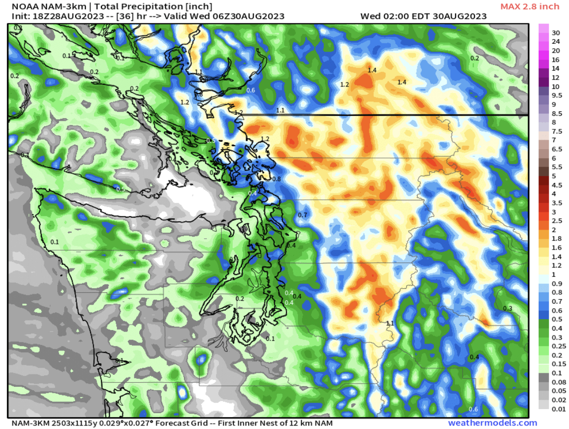
Next, we’ll look at the NAM high-resolution forecast, which shows far less rain than the European model (this is also through late Thursday).


The NAM shows a trace to 0.1” for most of the lowlands and Eastern Washington, with 0.2-0.5” on the coast. This does highlight a potential Puget Sound Convergence Zone feature, stretching from Bremerton toward Snoqualmie Pass, giving that area 0.2-0.4”.

Finally, the UW WRF high-resolution forecast, also showing rain through late Thursday.


The UW forecast shows a trace to 0.3” for the lowlands (least from Seattle to Tacoma), with a potential Convergence Zone from Seattle to Everett. The coast and areas from Olympia south toward Portland get the most rain, with 0.3-0.75”. In this forecast, Eastern Washington and the Cascades remain mostly dry.

The other aspect of the upcoming forecast is a relatively large increase in high temperatures over a few days. We’ll take a look at the European model forecasts showing temperatures on Thursday, Friday, and Saturday.

First, the forecast for highs on Thursday.


Expect Thursday's highs to be in the mid to upper 60s, with some readings in the low 70s, mainly in the Willamette Valley. The coast will reach the low to mid 60s, and Eastern Washington will have the coolest day in months, with highs in the upper 60s to low 70s.

Next, on Friday, temperatures will begin increasing across the state, seen below.


On Friday, with sunnier conditions, temperatures will climb to the mid to upper 70s (isolated low 80s) in the lowlands, the upper 70s to low 80s in the Willamette Valley, and the upper 70s to mid 80s in Eastern Washington. The coast will also warm up, with highs in the mid to upper 70s, except in the mid 60s at the ocean beaches.

Heat will peak on Saturday, with potentially the hottest conditions of September. The forecast for highs is below.


On Saturday, expect lowland highs in the low to mid 80s (same in the Willamette Valley), with Eastern Washington warming up even more to the mid 80s to low 90s. The coast will reach the mid 70s to low 80s, except in the upper 60s to low 70s at the beaches, a very nice September day!

As far as Labor Day Weekend goes, it won’t all be nice for Western Washington. Cloudier and cooler conditions, with a chance of showers, will return on Sunday. Below is the 15-day forecast for Seattle from the European Ensemble model.


Notice a spike on Saturday, with a dramatic decline to near-average conditions (highs in the upper 60s to low 70s) for the foreseeable future. Overnight lows will decrease from recent days, with lows in the low to mid 50s from Monday onward.

We’ll end by also taking a look at this same forecast for the Tri Cities, to show the outlook for Eastern Washington.


A similar trend can be seen for the Tri Cities, with temperatures peaking on Saturday, then dropping to seasonable levels for the foreseeable future.

Stay tuned for the forecast for Labor Day Weekend!

Monday, August 28, 2023

Western Washington Thunderstorm Update

No FastCast today…continue reading the full blog below for an update on the thunderstorm potential from late Monday night to early Tuesday morning.

Let’s take a look at the thunderstorm potential overnight. We will cover the rain forecast and take a look at the actual lightning potential. Finally, we’ll wrap up with a city-by-city look at the confidence in heavy rain (which corresponds to thunderstorms).

First, we’ll look at the rain forecast, starting with the European model forecast through late Tuesday.


The European model shows the heaviest rain from Central Lewis County north to Lynden, and eastward into the Cascades. This shows most of the lowlands picking up 0.3-1.2” of rain, most in the Cascades and parts of the foothills/Cascades.

Let’s compare this to the European Ensemble (EPS), essentially a smoothed-out version of the previous forecast.


The EPS shows decent rain (0.3-0.5”) for the entire lowlands, and 0.5-1” in the Cascades. 

Next, we’ll look at the GFS model, which is significantly different than the European.


The GFS shows slightly enhanced rain to the east of Tacoma and northward to Seattle, but this forecast can be considered an outlier.

Let’s round out these forecasts with the high-resolution NAM forecast.


The NAM, which is prone to significantly overdoing mountain precipitation, shows the heaviest rain in the mountains and in the lowlands from Kent northward. This is also an outlier among the consensus of forecasts, mainly due to the excessive rain amounts in the mountains.

Next, we‘ll look at lightning flash density, a measure of how much lightning is in the atmosphere. This is for early Tuesday morning, from the European model.


This forecast shows a high lightning flash density over and to the east of Puget Sound, which represents where the thunderstorms will be! 

A couple hours later, you can see the storms’ slow progress to the north and east.


Lightning flash density is still high immediately east of Puget Sound, and into the Cascades and on the eastern slopes.

Before we take a city-by-city look at precipitation potentials, let’s take a look at the areas of instability (CAPE index) from the UW WRF model, showing instability at 3 AM Tuesday.


This forecast shows elevated CAPE of 200-400 over the lowlands, and 400-800 over parts of the Cascades.

Now, we will look at a city-by-city forecast, showing 24-hour precipitation amounts from the European Ensemble forecast (EPS). This is something we will do later this season during atmospheric river events, and especially in any potential snow events.

We will start with Seattle, seen below.


The more ensemble members that show rain, the higher chance for thunderstorms. There is a relatively high confidence for thunderstorms in Seattle, as seen by about 90% of ensemble members showing rain.

Next, let’s look at Bellingham.


There is a high confidence for rain in Bellingham (90%), but lesser amounts than seen in Seattle, meaning that thunderstorms may be a bit weaker.

Next, we move south to Everett, seen below.


Everett has a similarly high chance of rain (90% of members), with amounts more than Bellingham but a bit less than Seattle.

We’ll continue moving south, now to Puyallup/South Hill.


There is about an 80% chance of rain and thunderstorms for Puyallup, with rain amounts scattered between 0.2-1”, showing some uncertainty about how much rain will fall.

Next, we’ll look at Tacoma, seen below.


Tacoma’s forecast is very similar to Puyallup, with about an 80-85% chance of rain/thunderstorms, and widely scattered rain amounts.

Moving further south, we’ll encounter diminishing rain chances in Olympia.


Notice the large change between Olympia and Tacoma, with 90% of the members not showing significant rain in Olympia, which will likely be too far west of the storms.

Finally, we’ll end in Bremerton, seen below.


Bremerton’s forecast shows 85-90% of the members with rain, some heavy. Essentially, Bremerton will be closer to the storms, with a forecast similar to Seattle and Tacoma.

Stay tuned over the next few days, as continued rain is expected, especially to start September. In the meantime, expect an update on Tuesday regarding significant rain in Eastern Washington!

Sunday, August 27, 2023

Significant Pattern Change: Rain, Thunderstorms, and Cooler Temperatures Ahead

 FastCast—Monday, Aug. 28 to Tuesday, Aug. 29:

Expect a thunderstorm-specific update on Monday afternoon! Stay tuned!

After highs reached the mid to upper 80s across Western Washington on Sunday, a significant pattern change is ahead. First of all, air quality will remain in the “moderate” to “unhealthy for sensitive groups” categories on Monday, with significant improvement to “good” on Tuesday. Temperatures will drop to the mid to upper 70s in the lowlands on Monday, and then drop further to the mid 60s to mid 70s on Tuesday, potentially the coolest day since June! This will be associated with a trough of low pressure moving inland, bringing a significant thunderstorm potential from Monday night to Tuesday morning, followed by showers through the day on Tuesday. The highest chance for thunderstorms in the lowlands is from late Monday night to early Tuesday morning, and this is also the best potential for heavy rain (0.3-0.7” possible within 6-12 hours). Rain amounts across the lowlands greatly depends on thunderstorm locations, with amounts of 0.1-0.8” in play, but the greatest likelihood for 0.25-0.75” through Tuesday evening. Continue reading below for more information and a breakdown of the thunderstorm potential.

——————————————————————

Continue reading the full blog below!

A noticeable pattern change is ahead for the Pacific Northwest over the next few days. The most significant features of this pattern change will be the removal of smoke by early Tuesday (in Western WA) and the significant thunderstorm potential from late Monday night to early Tuesday morning. Let’s take a look at the forecast!

First, we’ll look at the European Ensemble mean forecast for rain through late Tuesday.


This forecast shows 0.3-0.7” of rain along the I-5 corridor, with the most (0.5-0.7”) in the Cascades and from Eatonville northward. Areas with the heaviest precipitation amounts (blue, in this forecast) have the highest chance for thunderstorms. Eastern Washington will get less rain through late Tuesday, but stay tuned, as much more is expected there in the coming days.

We will now compare this to the GFS forecast, also showing total rain through late Tuesday.


The GFS has the heaviest rain (0.5-0.6”) for areas near Enumclaw northwest to Bellingham, with Tacoma and Olympia getting far less (0.1-0.3”) with thunderstorms staying to the east. This forecast also shows 0.3-0.5” of rain for parts of Eastern Washington.

Next, we will compare this to the high-resolution NAM forecast, also through late Tuesday.


The NAM, which is prone to overdoing heavy precipitation, shows thunderstorms tracking from Central Lewis County northwest to the Poulsbo area, going between Olympia and Tacoma, with additional thunderstorms in the Cascades and foothills, and in Eastern Washington. This forecast is essentially the European Ensemble’s forecast for the lowlands, just shifted west. 

Finally, we’ll compare this to the UW WRF forecast through early Wednesday, seen below.


This forecast is an outlier, showing most rain & thunderstorms from I-90 northward, both in the lowlands and foothills/Cascades. This forecast gives 0.3-1.25” of rain under thunderstorms, with amounts likely a bit overdone.

One very important ingredient for thunderstorms is instability, which is measured in CAPE, which stands for Convective Available Potential Energy. Below is the CAPE index from the UW WRF model on Monday evening.


Notice elevated CAPE over the lowlands and parts of the Cascades. That is good news for thunderstorms.

We will wrap up this blog with a look at the significantly decreasing temperatures expected over the next few days. Below is the European model forecast for highs on Monday.


On Monday, expect lowland highs in the mid to upper 70s, coastal highs in the low to mid 60s, and Willamette Valley highs in the upper 70s to low 80s. Eastern Washington will remain quite hot, with highs in the mid 90s to mid 100s.

However, significant cooling is expected across the state on Tuesday, as seen in the European model forecast below.


On Tuesday, expect lowland highs in the mid 60s to mid 70s, coastal highs in the low to mid 60s, and Willamette Valley highs in the mid 70s. For most areas west of the Cascades, this will be one of the coolest days since mid June. Eastern Washington will cool to the mid 70s to upper 80s.

Let’s take a quick look at the extended temperature & precipitation outlooks from the NWS Climate Prediction Center for September 2-6.


This shows an equal chance of above or below normal temperatures for the SE half of Washington, and a 33-40% probability of above normal temperatures for the NE half.

The precipitation outlook for September 2-6 is below.


This outlook shows a 40-60% probability of above average precipitation for the entirety of Washington to begin September.

Remember, I will be posting a thunderstorm-specific update on Monday afternoon. Stay tuned!

Thursday, August 24, 2023

Update: High Fire Danger, Increasing Heat, and Lingering Smoke

No FastCast tonight…continue reading below for an update on the significant fire danger threat, increasing heat, and lingering surface smoke.

We will begin with the high fire danger threat on Friday. Below is the NWS Storm Prediction Center fire weather outlook.


The outlined region stands for “isolated dry thunderstorms.” A dry thunderstorm is a thunderstorm will little to no rain, which means lightning can easily start fires. There is a threat of dry thunderstorms in the Cascades from Central Oregon to North Central Washington, with the potential including the I-5 corridor from Portland to Everett.

The highest chance of thunderstorms will be late Thursday night to early Friday morning from Olympia south, and from Friday morning onward in the Cascades. The thunderstorm chance is much lower in the Seattle metro area, but it’s still possible.

Another indicator of dry thunderstorms is the rain forecast. Below is the European model rain forecast for Friday.


Notice that the most rain in the Cascades is 0.2”, and that is very isolated, with most of the Cascades getting 0.01-0.15”. With so little rain, it is very hard to put out lightning-caused fires.

Fire weather will only be enhanced by offshore winds through the Cascades, especially the gaps, as seen in the NAM high-resolution model forecast for early Friday morning.


The red outlined area shows gap winds, which will decrease humidity and promote fire growth. 

Below is the area included in a Red Flag Warning on Friday.


Red Flag Warnings are in effect for most of the Oregon Cascades and the Washington Cascades from the Oregon border to Snohomish County.

The reason for Red Flag Warnings is the combination of dry thunderstorms, breezy winds, and low relative humidity. Below is the forecast for relative humidity on Saturday afternoon.


Expect relative humidity to drop to 20-35% in the lowlands and 10-25% in Eastern Washington. These are humidity levels that will promote fire spread due to the dry conditions.

Let’s wrap up this blog by looking at smoke and heat. Below is the surface smoke forecast for 7 AM Friday from the HRRR Smoke model.


This forecast shows moderate concentrations of surface smoke around most of Western Washington on Friday morning, with slightly heavier concentrations across most of Eastern Washington. Expect air quality in the “moderate” to “unhealthy for sensitive groups” categories (51-149). Areas close to fires and in mountain valleys could reach “unhealthy” (150-200). 

By 4 PM Friday, smoke will have lessened somewhat with potential thunderstorms moving south to north through the region.


This forecast shows far less smoke over most of the lowlands and limited smoke coverage for Eastern Washington. However, this forecast and the future smoke forecast is subject to change with potential new fire starts and different thunderstorm conditions (less thunderstorms = higher smoke potential).

Finally, let’s take a look at upcoming temperatures, starting with Friday’s forecast from the European model.


On Friday, expect lowland highs in the mid to upper 80s, except in the low 80s from Everett northward. This will be a hot day on the coast, with highs in the low to mid 80s, except in the mid 70s at the beaches. The Willamette Valley will reach the low 90s and Eastern Washington will reach the upper 70s to upper 80s, a bit cooler due to smoke and potential thunderstorms.

Temperatures will increase further on Saturday, as seen below.


On Saturday, expect lowland highs in the upper 80s to low 90s, except in the mid 90s around Shelton. The Willamette Valley will reach the low to mid 90s, and Eastern Washington will reach the mid 80s to upper 90s. The coast will begin cooling, with highs in the mid to upper 70s (except in the upper 60s to low 70s at the beaches).

Lastly, a look at the forecast for Sunday, seen below.


Sunday looks to be the hottest day in the lowlands, with highs reaching the upper 80s to low 90s, with mid 90s possible from Tacoma south and west to Shelton. The Willamette Valley will reach the upper 80s to low 90s, Eastern Washington will increase to the low 90s to low 100s, and the coast will continue to cool to the low 70s, except the mid to upper 60s at the beaches.

Stay tuned as more active weather is possible in the coming days!

Wednesday, August 23, 2023

Return of Smoke, Another Heat Wave, and a Chance of Thunderstorms Ahead

FastCast—Thursday, Aug. 24 to Sunday, Aug. 27:

Heat, smoke, and a chance of thunderstorms are all ahead for Western Washington in the coming days. Surface smoke will increase on Thursday and into early Friday after smoke aloft moved in, bringing hazy skies on Wednesday. Air quality will not degrade as much as earlier this week due to less dense smoke, but degraded air quality is expected, especially from late Thursday to early Friday. Heat will build into the weekend, with temperatures increasing from the mid to upper 70s on Thursday to the mid to upper 80s on Friday. Temperatures increase further to the upper 80s to low 90s on Saturday and Sunday. Lows will increase to the upper 50s, thankfully not as uncomfortable as the last heat wave. One important note is that smoke (aloft and surface) can decrease temperatures, so forecasted highs aren’t absolute. Additionally, there is a chance of thunderstorms on Friday, with potential for lightning and heavy rain. Mountain thunderstorms have the potential to start new fires. Finally, elevated fire weather is expected in the Cascades on Thursday and Friday due to easterly winds and low relative humidity. Remember that one spark can start a devastating wildfire. Do your part to prevent wildfires at all times!

———————————————————

Continue reading the full blog below!

A heat wave, the return of surface smoke, and a chance of thunderstorms are all ahead for Western Washington in the coming days. Let’s take a look at the forecast!

First, we will take a look at the return of surface smoke, using the HRRR smoke forecast. We’ll start with 8 AM Thursday.


On Thursday morning, light surface smoke is expected across most of Washington state, with higher concentrations at higher elevations.

By Thursday afternoon (around 3 PM), the situation has deteriorated some.


Notice that by Thursday afternoon, smoke concentrations are thicker across the entire state, from the Idaho border to the ocean beaches. However, these concentrations aren’t nearly as thick as our previous round of smoke, meaning that air quality won’t be as unhealthy as last time, but still noticeably degraded.

Smoke will increase further overnight Thursday into Friday, as seen in the forecast for 3 AM Friday.


Notice how smoke has been pulled south from British Columbia, resulting in the worst smoke being in Whatcom and San Juan Counties, along the Strait, and in Eastern WA from I-90 northward. The Puget Sound area has moderate surface smoke concentrations early Friday morning.

Due to the expected degradation of air quality, be mindful that if you sleep with your windows open from Thursday night to Friday morning, you may be letting hazardous smoke particles into your home.

Now, we will change gears and focus on temperatures, which will be increasing significantly from Friday onward. Remember that smoke can significantly alter high temperatures. These temperatures shown below are not absolute, and temperatures a few degrees cooler are definitely possible due to smoke.

Below is the European model forecast for Thursday’s highs.


On Thursday, expect lowland highs in the upper 70s to low 80s, with highs in the low to mid 80s around Olympia and Shelton, in the low 90s in the Willamette Valley, and in the upper 70s to low 80s on the coast (upper 60s to low 70s at the ocean beaches). Eastern Washington will reach the upper 70s to low 90s.

Temperatures increase significantly on Friday, especially west of the Cascades, as seen below.


On Friday, expect lowland highs in the mid 80s to low 90s, with the Willamette Valley reaching the low to mid 90s, and the coast reaching the upper 70s to upper 80s, except in the mid 70s at the ocean beaches. Eastern Washington will warm to the low 80s to mid 90s, hottest in the Columbia Basin.

Temperatures will remain hot on Saturday, as seen below.


On Saturday, expect lowland highs in the upper 80s to low 90s, except near the water. The coast will begin cooling, with highs in the upper 60s to mid 70s, except in the mid to upper 60s at the beaches. The Willamette Valley will reach the low to mid 90s, and Eastern Washington will warm significantly to the upper 80s to upper 90s.

In addition to the heat wave, elevated fire weather concerns are expected on Thursday and Friday. The NWS Seattle graphic below explains the Red Flag Warning for the Cascades from King County southward.


These conditions will lead to potentially explosive fire growth. Outside the Cascades, relative humidity will drop to 30-40% in Western WA and 10-30% in Eastern WA. An uptick in activity is expected at most fires. Be extra mindful of your activities that could potentially lead to a spark.

Finally, we’ll take a look at the upcoming chance of thunderstorms, greatest on Friday. The UW WRF forecast below shows the CAPE index (instability) on Friday.


Notice an area of 200-700 CAPE in parts of Western Washington and the Cascades. This shows that there is a potential for thunderstorms.

The graphic below from the NAM high-resolution forecast shows simulated weather radar at 7 AM Friday.


This simulated radar image shows thunderstorms moving north across a large portion of Washington. Although the radar shows rain, the storms may not produce much rain, increasing the potential for dry lightning, which can easily start fires.

Finally, the simulated radar image from the HRRR high-resolution forecast, also for 7 AM Friday.


This forecast also shows thunderstorms moving north across most of the state on Friday morning. Again, just because the radar shows rain doesn’t mean it will rain. 

With all the potential weather ahead, I will have another update Thursday night with the latest information on potential Friday thunderstorms, the upcoming heat wave, and more.

Short Spring Heat Wave for the Pacific Northwest

  FastCast--Thursday, May 9 to Tuesday, May 14: A spring "heat wave" is ahead for the Northwest, with the warmest temperatures see...