FastCast—Monday, Aug. 7 to Thursday, Aug. 10:
After showers over the weekend didn’t amount to much in Western Washington (though thunderstorms were plentiful in Eastern WA), widespread rain is likely this week, mainly from midday Tuesday through Wednesday evening. Up to 0.1-0.5” is likely across Western Washington, with higher amounts up to 1” in the mountains. There is a chance of some areas of light rain or drizzle across Western Washington on Monday morning, as well. High temperatures will be in the mid 70s to low 80s through Thursday, except in the mid 70s on Wednesday. Conditions will remain on the muggy side on Monday, though less muggy than Sunday. Additionally, wildfire smoke aloft will move out of the area by Tuesday. Expect partly to mostly cloudy conditions through Thursday, with some afternoon clearing each day except Wednesday.
————————————————————
Continue reading the full blog below!
Showers didn’t amount to much over the weekend, but more rain is expected through midweek.
Let’s take a look at the rain forecasts. We’ll compare the European and GFS forecasts, starting with the European model below, showing rain through late Wednesday.
The European model shows 0.1-0.4” of rain across the lowlands, most from late Tuesday through Wednesday. Areas from Everett northward and on the coast will get 0.4-0.6”. The mountains will get up to 0.5-1”, and Eastern Washington will get 0.1-1.25”, with amounts varying based on where thunderstorms set up, but higher amounts are likely from Kennewick and Moses Lake eastward and in the mountains.
Let’s compare this to the GFS forecast, also through late Wednesday.
The GFS paints a different picture, with significant rain from Seattle northward and much less from Seattle southward. This forecast shows 0.5-1.25” of rain on a line from Seattle to Aberdeen northward, and 0.1-0.3” south of that line. Eastern Washington’s amounts are scattered in this forecast, ranging from 0.1-0.9”.
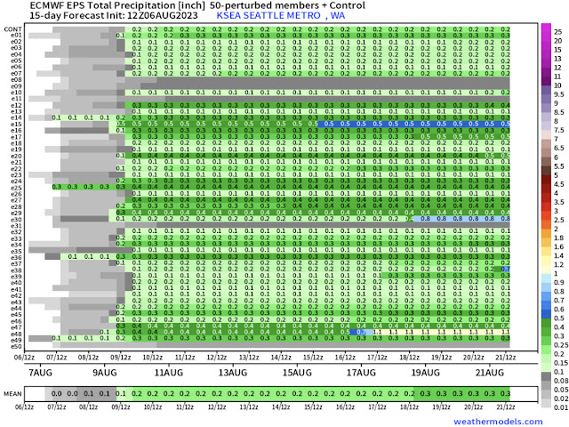
Let’s take a different look at this forecast, showing European and GFS ensemble forecasts for Seattle, starting with the European model ensemble, known as the EPS.
The European model ensemble has very good agreement for 0.1-0.3” of rain in Seattle by late Tuesday, with a good chance of up to 0.1” of light rain on Monday morning.
Let’s compare this to the GFS ensemble, known as the GEFS.
This is a very interesting forecast. It shows the potential for up to 0.2” of rain by midday Monday, and has some ensemble members showing much more rain (up to 1”) in Seattle, but others show only 0.1” more rain through Wednesday.
Essentially, what can be taken from these graphics is that the European ensemble has good agreement, but the GFS ensemble is still uncertain. Either way, at least 0.1” of rain, and likely more, is expected for most of Western Washington through midweek.
Now, what about temperatures? Let’s take a look at the European model forecast for highs on Monday.
Expect Monday’s highs to reach the mid 70s to low 80s in the lowlands, low to mid 60s on the coast, and mid 70s to upper 80s in Eastern Washington, hottest in the Columbia Basin.
Next, Tuesday’s highs, also from the European model.
Tuesday is a bit different, with lowland highs south of Everett in the mid to upper 70s, and highs north of Everett in the mid 60s to low 70s, due to advancing precipitation. The coast will reach the upper 50s to low 60s. Eastern Washington will be warmer than Monday, with highs in the upper 70s to low 90s.
Finally, Wednesday’s highs, also from the European model.
On Wednesday, expect lowland highs in the low to mid 70s, coastal highs in the low to mid 60s, and Eastern Washington’s highs in the upper 70s to low 90s.
Enjoy this chance of rain and break from hot temperatures, as we continue to watch a potential heat wave next week.


No comments:
Post a Comment