No FastCast today…continue reading the full blog below.
After a refreshing night, with overnight lows in the upper 40s to mid 50s, smoke is slowly moving into Western Washington from fires in the Cascades and across British Columbia.
————————————————
3 Important Reminders:
-In light of our recent heat wave, the best time to cool your house will be until around 10-11 AM Saturday morning in Western Washington. After that, air quality will be degrading rapidly and keeping your windows open will only draw in smoke
-Air quality will be significantly degraded across the entire state. Check statewide air quality below, and zoom in to your location for accurate hyper-local air quality information.
PurpleAir Washington State Air Quality Map
-By Saturday afternoon, air quality will likely be unsafe to be outside. If you are outside, wear a respirator mask. If you’re inside, either close your windows or use a box fan with a MERV 13 HVAC filter attached to it. If you are using air conditioning, a MERV 13 filter will filter out the potentially hazardous PM2.5 particles that come with smoke.
————————————————
Let’s take a look at the smoke event forecast. It is most likely (as of the writing of this blog) that surface smoke will increase through Saturday, peak on Sunday, and then begin to decrease early Monday morning.
Below is the UW Atmospheric Sciences satellite loop as of 9:45 AM Saturday.

Smoke is clearly entrenched across Eastern Washington, with air quality reaching 150-400 across the region. Smoke is slowly pushing south and west into Western Washington, with smoke aloft moving in first, followed by lower and denser surface smoke.
The HRRR smoke forecast for 10 AM largely matches up with this satellite image.
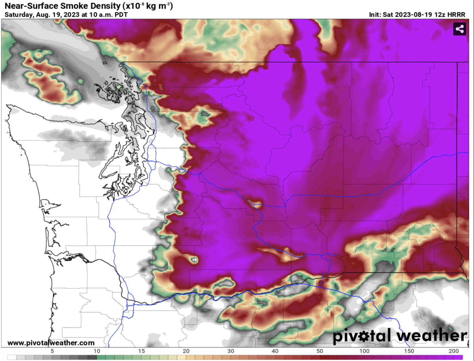
Surface smoke is very dense across Eastern Washington, and is slowly beginning to push south and west out of Canada and through the Cascades into Western Washington.
Expect to see skies cloud up with smoke as smoke aloft moves into Western WA prior to surface smoke. This same situation will happen in reverse when smoke clears out, with surface smoke clearing first, followed by smoke aloft.
By 4 PM Saturday, dense surface smoke has been pouring into Western Washington for hours, and that shows on this forecast.

By around 4 PM, the entire state except the coast from Ocean Shores southward is covered in surface smoke. Smoke concentrations in Eastern Washington are at the top of the scale, likely equivalent to “hazardous” air quality.
Smoke will continue to get denser and air quality will degrade further overnight Saturday into Sunday. DO NOT sleep with your windows open, as it will expose you to very unhealthy air quality. If you must have your windows open, use a box fan with a MERV 13 air filter attached to it.
By 7 AM Sunday, the situation is worse for the whole state.

Surface smoke has reached the coast and covers the entire state. Concentrations remain very dense and unhealthy for most of Eastern Washington and parts of Western Washington. In the lowlands, smoke hasn’t peaked yet.
By 2 PM Sunday, smoke concentrations are downright horrible in the lowlands.

If this forecast remains correct, the lowlands will have reached the top of the scale for the densest smoke concentrations forecasted by this model. This means it will be hazardous for anyone to be outside, unless you have a respirator mask that will protect you. Even with that, limit your time outside.
You can see that smoke relief is beginning on the coast, with marine air just offshore beginning to push the smoke back east.
A word of caution: In recent smoke events, forecasts have had quite a hard time with the timing of smoke relief. Last October, smoke cleared multiple days later than forecasts initially thought. Remember that smoke forecasts are uncertain, especially when we’re talking about smoke clearing out.
By 7 PM Sunday, some relief is noticeable, but the situation remains dangerous.

By 7 PM Sunday, smoke looks to be substantially decreased along the coast and in Asotin County, as marine air and fresher tropical air (from the remnants of Hurricane Hilary) work on the west and east sides of the smoke, respectively.
However, the vast majority of the state remains in hazardous concentrations of smoke through Sunday evening and into the night.
By 5 AM Monday (the limit of this forecast), more relief is noticeable.

By early Monday morning, noticeable relief is visible, especially in Western Washington. The coast could be clear, with marine winds pushing into the lowlands and slowly trying to clear out the smoke. Air quality will still be degraded at this time. Meanwhile, winds from the remnants of Hurricane Hilary will be pushing smoke west out of the far eastern portion of Eastern WA, including Spokane.
However, the Cascade foothills and most of Eastern Washington remain in very unhealthy to hazardous air quality by early Monday morning.
With all this hazardous smoke ahead, it is important to know the categories of air quality. In the graphic below, you can see the categories, numbers that correspond with them, and the description for each category.

When air quality levels reach “unhealthy” or worse, everyone can be impacted, regardless of age, underlying conditions, or any other factors.
Stay tuned for more updates, and remember to protect yourself from this smoke by staying inside when necessary and taking proper precautions.

This was a great update on the smoke in our area, thank you.
ReplyDelete