FastCast—Thursday, Aug. 24 to Sunday, Aug. 27:
Heat, smoke, and a chance of thunderstorms are all ahead for Western Washington in the coming days. Surface smoke will increase on Thursday and into early Friday after smoke aloft moved in, bringing hazy skies on Wednesday. Air quality will not degrade as much as earlier this week due to less dense smoke, but degraded air quality is expected, especially from late Thursday to early Friday. Heat will build into the weekend, with temperatures increasing from the mid to upper 70s on Thursday to the mid to upper 80s on Friday. Temperatures increase further to the upper 80s to low 90s on Saturday and Sunday. Lows will increase to the upper 50s, thankfully not as uncomfortable as the last heat wave. One important note is that smoke (aloft and surface) can decrease temperatures, so forecasted highs aren’t absolute. Additionally, there is a chance of thunderstorms on Friday, with potential for lightning and heavy rain. Mountain thunderstorms have the potential to start new fires. Finally, elevated fire weather is expected in the Cascades on Thursday and Friday due to easterly winds and low relative humidity. Remember that one spark can start a devastating wildfire. Do your part to prevent wildfires at all times!
———————————————————
Continue reading the full blog below!
A heat wave, the return of surface smoke, and a chance of thunderstorms are all ahead for Western Washington in the coming days. Let’s take a look at the forecast!
First, we will take a look at the return of surface smoke, using the HRRR smoke forecast. We’ll start with 8 AM Thursday.

On Thursday morning, light surface smoke is expected across most of Washington state, with higher concentrations at higher elevations.
By Thursday afternoon (around 3 PM), the situation has deteriorated some.

Notice that by Thursday afternoon, smoke concentrations are thicker across the entire state, from the Idaho border to the ocean beaches. However, these concentrations aren’t nearly as thick as our previous round of smoke, meaning that air quality won’t be as unhealthy as last time, but still noticeably degraded.
Smoke will increase further overnight Thursday into Friday, as seen in the forecast for 3 AM Friday.

Notice how smoke has been pulled south from British Columbia, resulting in the worst smoke being in Whatcom and San Juan Counties, along the Strait, and in Eastern WA from I-90 northward. The Puget Sound area has moderate surface smoke concentrations early Friday morning.
Due to the expected degradation of air quality, be mindful that if you sleep with your windows open from Thursday night to Friday morning, you may be letting hazardous smoke particles into your home.
Now, we will change gears and focus on temperatures, which will be increasing significantly from Friday onward. Remember that smoke can significantly alter high temperatures. These temperatures shown below are not absolute, and temperatures a few degrees cooler are definitely possible due to smoke.
Below is the European model forecast for Thursday’s highs.

On Thursday, expect lowland highs in the upper 70s to low 80s, with highs in the low to mid 80s around Olympia and Shelton, in the low 90s in the Willamette Valley, and in the upper 70s to low 80s on the coast (upper 60s to low 70s at the ocean beaches). Eastern Washington will reach the upper 70s to low 90s.
Temperatures increase significantly on Friday, especially west of the Cascades, as seen below.

On Friday, expect lowland highs in the mid 80s to low 90s, with the Willamette Valley reaching the low to mid 90s, and the coast reaching the upper 70s to upper 80s, except in the mid 70s at the ocean beaches. Eastern Washington will warm to the low 80s to mid 90s, hottest in the Columbia Basin.
Temperatures will remain hot on Saturday, as seen below.

On Saturday, expect lowland highs in the upper 80s to low 90s, except near the water. The coast will begin cooling, with highs in the upper 60s to mid 70s, except in the mid to upper 60s at the beaches. The Willamette Valley will reach the low to mid 90s, and Eastern Washington will warm significantly to the upper 80s to upper 90s.
In addition to the heat wave, elevated fire weather concerns are expected on Thursday and Friday. The NWS Seattle graphic below explains the Red Flag Warning for the Cascades from King County southward.

These conditions will lead to potentially explosive fire growth. Outside the Cascades, relative humidity will drop to 30-40% in Western WA and 10-30% in Eastern WA. An uptick in activity is expected at most fires. Be extra mindful of your activities that could potentially lead to a spark.
Finally, we’ll take a look at the upcoming chance of thunderstorms, greatest on Friday. The UW WRF forecast below shows the CAPE index (instability) on Friday.

Notice an area of 200-700 CAPE in parts of Western Washington and the Cascades. This shows that there is a potential for thunderstorms.
The graphic below from the NAM high-resolution forecast shows simulated weather radar at 7 AM Friday.
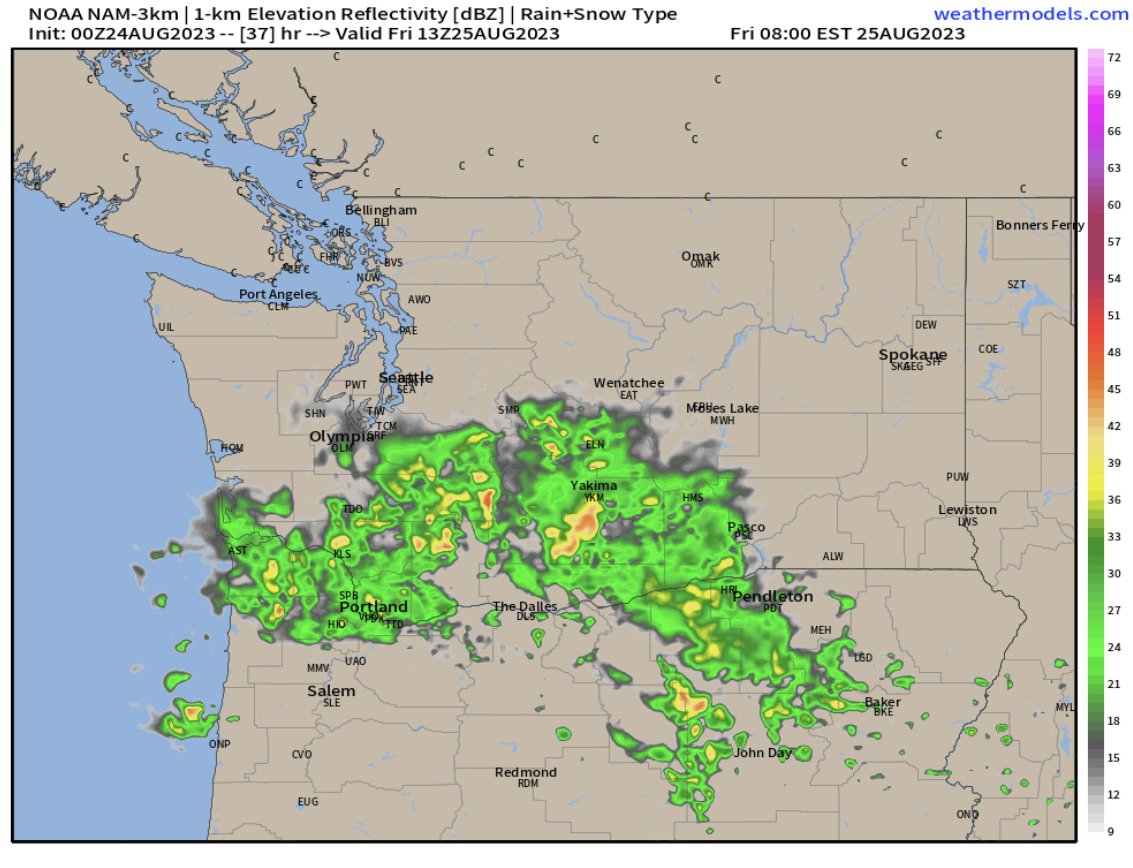
This simulated radar image shows thunderstorms moving north across a large portion of Washington. Although the radar shows rain, the storms may not produce much rain, increasing the potential for dry lightning, which can easily start fires.
Finally, the simulated radar image from the HRRR high-resolution forecast, also for 7 AM Friday.

This forecast also shows thunderstorms moving north across most of the state on Friday morning. Again, just because the radar shows rain doesn’t mean it will rain.
With all the potential weather ahead, I will have another update Thursday night with the latest information on potential Friday thunderstorms, the upcoming heat wave, and more.

No comments:
Post a Comment