No FastCast tonight…continue reading below for an update on the significant fire danger threat, increasing heat, and lingering surface smoke.
We will begin with the high fire danger threat on Friday. Below is the NWS Storm Prediction Center fire weather outlook.
The outlined region stands for “isolated dry thunderstorms.” A dry thunderstorm is a thunderstorm will little to no rain, which means lightning can easily start fires. There is a threat of dry thunderstorms in the Cascades from Central Oregon to North Central Washington, with the potential including the I-5 corridor from Portland to Everett.
The highest chance of thunderstorms will be late Thursday night to early Friday morning from Olympia south, and from Friday morning onward in the Cascades. The thunderstorm chance is much lower in the Seattle metro area, but it’s still possible.
Another indicator of dry thunderstorms is the rain forecast. Below is the European model rain forecast for Friday.
Notice that the most rain in the Cascades is 0.2”, and that is very isolated, with most of the Cascades getting 0.01-0.15”. With so little rain, it is very hard to put out lightning-caused fires.
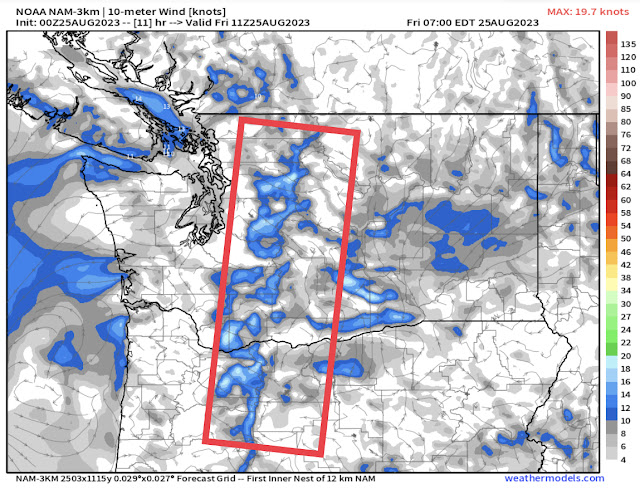
Fire weather will only be enhanced by offshore winds through the Cascades, especially the gaps, as seen in the NAM high-resolution model forecast for early Friday morning.
The red outlined area shows gap winds, which will decrease humidity and promote fire growth.
Below is the area included in a Red Flag Warning on Friday.
Red Flag Warnings are in effect for most of the Oregon Cascades and the Washington Cascades from the Oregon border to Snohomish County.
The reason for Red Flag Warnings is the combination of dry thunderstorms, breezy winds, and low relative humidity. Below is the forecast for relative humidity on Saturday afternoon.
Expect relative humidity to drop to 20-35% in the lowlands and 10-25% in Eastern Washington. These are humidity levels that will promote fire spread due to the dry conditions.
Let’s wrap up this blog by looking at smoke and heat. Below is the surface smoke forecast for 7 AM Friday from the HRRR Smoke model.
This forecast shows far less smoke over most of the lowlands and limited smoke coverage for Eastern Washington. However, this forecast and the future smoke forecast is subject to change with potential new fire starts and different thunderstorm conditions (less thunderstorms = higher smoke potential).
On Saturday, expect lowland highs in the upper 80s to low 90s, except in the mid 90s around Shelton. The Willamette Valley will reach the low to mid 90s, and Eastern Washington will reach the mid 80s to upper 90s. The coast will begin cooling, with highs in the mid to upper 70s (except in the upper 60s to low 70s at the beaches).
Lastly, a look at the forecast for Sunday, seen below.
Sunday looks to be the hottest day in the lowlands, with highs reaching the upper 80s to low 90s, with mid 90s possible from Tacoma south and west to Shelton. The Willamette Valley will reach the upper 80s to low 90s, Eastern Washington will increase to the low 90s to low 100s, and the coast will continue to cool to the low 70s, except the mid to upper 60s at the beaches.
Stay tuned as more active weather is possible in the coming days!


Your weather reports are interesting and helpful. Thank you
ReplyDelete