No FastCast today…continue reading the full blog below for an update on the thunderstorm potential from late Monday night to early Tuesday morning.
Let’s take a look at the thunderstorm potential overnight. We will cover the rain forecast and take a look at the actual lightning potential. Finally, we’ll wrap up with a city-by-city look at the confidence in heavy rain (which corresponds to thunderstorms).
First, we’ll look at the rain forecast, starting with the European model forecast through late Tuesday.

The European model shows the heaviest rain from Central Lewis County north to Lynden, and eastward into the Cascades. This shows most of the lowlands picking up 0.3-1.2” of rain, most in the Cascades and parts of the foothills/Cascades.
Let’s compare this to the European Ensemble (EPS), essentially a smoothed-out version of the previous forecast.

The EPS shows decent rain (0.3-0.5”) for the entire lowlands, and 0.5-1” in the Cascades.
Next, we’ll look at the GFS model, which is significantly different than the European.

The GFS shows slightly enhanced rain to the east of Tacoma and northward to Seattle, but this forecast can be considered an outlier.
Let’s round out these forecasts with the high-resolution NAM forecast.
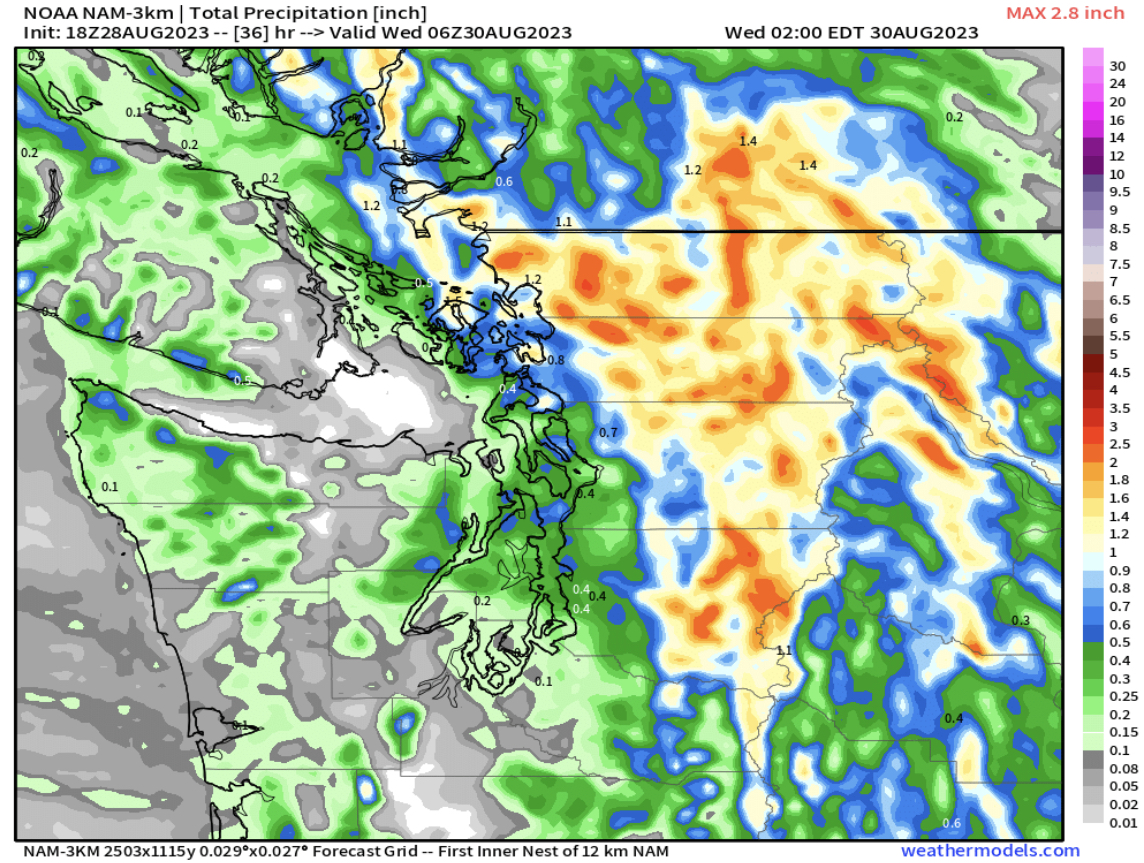
The NAM, which is prone to significantly overdoing mountain precipitation, shows the heaviest rain in the mountains and in the lowlands from Kent northward. This is also an outlier among the consensus of forecasts, mainly due to the excessive rain amounts in the mountains.
Next, we‘ll look at lightning flash density, a measure of how much lightning is in the atmosphere. This is for early Tuesday morning, from the European model.

This forecast shows a high lightning flash density over and to the east of Puget Sound, which represents where the thunderstorms will be!
A couple hours later, you can see the storms’ slow progress to the north and east.

Lightning flash density is still high immediately east of Puget Sound, and into the Cascades and on the eastern slopes.
Before we take a city-by-city look at precipitation potentials, let’s take a look at the areas of instability (CAPE index) from the UW WRF model, showing instability at 3 AM Tuesday.

This forecast shows elevated CAPE of 200-400 over the lowlands, and 400-800 over parts of the Cascades.
Now, we will look at a city-by-city forecast, showing 24-hour precipitation amounts from the European Ensemble forecast (EPS). This is something we will do later this season during atmospheric river events, and especially in any potential snow events.
We will start with Seattle, seen below.

The more ensemble members that show rain, the higher chance for thunderstorms. There is a relatively high confidence for thunderstorms in Seattle, as seen by about 90% of ensemble members showing rain.
Next, let’s look at Bellingham.

There is a high confidence for rain in Bellingham (90%), but lesser amounts than seen in Seattle, meaning that thunderstorms may be a bit weaker.
Next, we move south to Everett, seen below.

Everett has a similarly high chance of rain (90% of members), with amounts more than Bellingham but a bit less than Seattle.
We’ll continue moving south, now to Puyallup/South Hill.

There is about an 80% chance of rain and thunderstorms for Puyallup, with rain amounts scattered between 0.2-1”, showing some uncertainty about how much rain will fall.
Next, we’ll look at Tacoma, seen below.

Tacoma’s forecast is very similar to Puyallup, with about an 80-85% chance of rain/thunderstorms, and widely scattered rain amounts.
Moving further south, we’ll encounter diminishing rain chances in Olympia.

Notice the large change between Olympia and Tacoma, with 90% of the members not showing significant rain in Olympia, which will likely be too far west of the storms.
Finally, we’ll end in Bremerton, seen below.

Bremerton’s forecast shows 85-90% of the members with rain, some heavy. Essentially, Bremerton will be closer to the storms, with a forecast similar to Seattle and Tacoma.
Stay tuned over the next few days, as continued rain is expected, especially to start September. In the meantime, expect an update on Tuesday regarding significant rain in Eastern Washington!

No comments:
Post a Comment