Friday, January 29, 2021

Rainy Few Days Ahead

We have enjoyed a relative break from the relentless rain that impacted Western Washington to start 2021. That rain moved south, as a major storm impacted California this past week. I’ve attached a link to an article from The Weather Channel showing some of the impacts from the California storm.

https://weather.com/news/news/2021-01-27-california-debris-flow-flooding-snow-winter-storm

The impacts from this storm included: 3-10 feet of snow, 2-12 inches of rain, 40-80 mph winds, landslides, debris flows, and even blizzard conditions. Wow! That’s a lot of action for a few days!

Back here in Western Washington, we will end January with another round of rain that will continue into February. The UW forecast model below shows expected rain through 4 AM Monday.


Expect 0.3-0.7 inches of rain, starting Friday night, with the most on Sunday. Also...take a look at the awesome rain shadow effect on the north side of the Olympic Mountains! (Head up to Port Angeles if you want sun)

Additionally, expect some mountain snow with this weekend’s weather systems. The graphic below from NWS Seattle shows expected snow accumulations through Monday night. (Click to enlarge)


Be prepared for some snow if you’re crossing the mountains this weekend!

Some breezy conditions, with winds gusting 20-35 mph, are possible through the weekend as well.

A break from the rain is likely by Tuesday night. By the end of next week, colder weather is possible...a topic for a future blog.

Tuesday, January 26, 2021

Dry Easterly Winds Scour Out Snow

Easterly winds out of the Cascades have effectively ended the chance of snow Tuesday night into Wednesday morning. Easterly winds tend to dry the air and warm the temperature...scouring out precipitation and being hostile to snow.

Some areas saw brief snowflakes, but no accumulation occurred in the lowlands. Snow has accumulated in parts of Grays Harbor County, the Kitsap Peninsula, SW WA, and the Portland/Salem area.

As of 9:15 PM Tuesday, relative humidity in the South Sound was around 40-80% and temperatures were in the upper 30s-low 40s.

Below is relative humidity at 9:15 PM. Too dry for snow.


This graphic below from NWS Seattle shows that no snow is expected over the lowlands through Wednesday morning.


Why is no snow expected over the lowlands?

A low pressure system is sitting offshore right now, and it is drawing air through the gaps in the Cascades. This is the same system that is bringing extreme weather to California.


The graphic above shows where weaknesses in the Cascades are. With this storm, the strongest winds will be in the foothills and areas "downstream" of Enumclaw and North Bend.

A Wind Advisory is in effect for the Cascade foothills through 12 AM Wednesday. You can view this alert below.


Winds gusting to 45 mph are possible in these areas. Lesser winds, gusting 20-30 mph, are possible in areas between South Hill and Everett.

What about snow? Will there be any?

The answer to that question is that it depends. Snow is most likely in the Hood Canal Area on the Kitsap Peninsula and along parts of the Washington Coast, due to those areas' relation to the low center.

Flurries of snow and a localized dusting are possible in the lowlands overnight into Wednesday, but that isn't likely. 

Expect chilly weather, with highs 40-47 degrees and lows 30-36 degrees, for the next week or so.

The next blog post will feature an analysis of the major storm in California as well as an update on our weather.


Monday, January 25, 2021

Cold Night, Slight Snow Chances, Major Southwest US Storm

After a chilly day with scattered showers and breezy conditions, a cold night is expected. The map below from NWS Seattle shows expected low temperatures.


Expect low temperatures of 25-30 degrees on Tuesday morning. This could cause some spotty black ice, so be prepared.

Regarding snow: 

You might see flakes. The best chance of flakes falling will be Tuesday night into Wednesday morning. If you do see snow, it will not accumulate much, if at all. 


The map below from NWS Seattle shows snowfall from Monday night to Wednesday morning.


Higher hills, mainly above 500 feet, could see a dusting of snow on the grass from Tuesday night into Wednesday morning. If that occurs, don't expect big impacts. The most likely amounts of snow are 0.1-0.5 inches.

Expect high temperatures in the 40s with lows in the 30s for most of this week. Rain will make a return as well.

While major snow is not happening in the state of Washington, a pair of winter storms are moving through the Southwest United States. 

Below is a photo from my relatives in the Flagstaff, Arizona area that shows heavy snow accumulations of 10-25 inches as of Monday afternoon.


Look at all that snow!!! Additional impacts of heavy rain, strong winds, blizzard conditions, and incredible amounts of snow will be impacting California this week. The graphic below from NWS Sacramento shows the massive snow coming to the Sierra Nevada through the end of the week.


Let's put this into perspective: 80-100 inches of snow is 6-8 FEET of snow! (Makes our fuss over a few flakes disappointing!) Where the precipitation is rain, there will be 1-4 inches of rain over a couple days, and that is a major threat with the massive (500,000+ acre) burn scars in the area. California will surely be in the weather headlines this week.

Saturday, January 23, 2021

Cold Rain, Slim Snow Chances

Saturday morning was one of the coldest mornings in over a year in the lowlands. Take a look at our low temperatures.


Brrr!! Down to the 20s across most of the area!

Saturday night into Sunday will not be as cold, with lows of 34-37 degrees. In turn, the chance of snow is nearly nonexistent. 

In fact, the UW forecast model through 4 PM Tuesday shows no snow accumulation in the South Sound, with only some light accumulations (0.25-1 inch possible) in a convergence zone possible north of Seattle on Sunday night/Monday.


Although the chance of accumulating snow in the lowlands is unlikely, don't be surprised to see some snowflakes flying mixed with rain.

The best chances of seeing wet snow will be for those above 500 feet AND/OR in heavier showers where brief wet snow (likely non-accumulating) is possible.

The UW forecast for rain through 4 PM Tuesday is below, with 0.1-0.5 inches possible.


Stay tuned...as additional chances of rain/snow mix or brief wet snow are possible throughout the next week as colder than average temperatures continue.

Major impacts from snow are NOT likely in the Puget Sound Lowlands at this time.

Thursday, January 21, 2021

Colder Weather, Chance(s) of Rain/Snow Mix This Weekend

After a relatively uneventful week weather-wise, some colder weather with multiple chances of rain/snow mix or wet snow is ahead. Let’s take a look at the details.

Friday will be foggy in the morning, and sunny with highs in the mid-40s for the rest of the day.

Friday night/Saturday morning will be chilly with patchy fog. In some cases this will be freezing fog, which can be hazardous and produce dangerous black ice.

Below is the forecast low temperatures on Saturday morning (from the Euro model).


Expect lows of 26-28 degrees. Saturday will be foggy, then mostly sunny with highs of 40-45 degrees.

Saturday night into Sunday will bring a chance of rain/snow mix or brief wet snow, most likely above 500 feet and early Sunday morning.

There is a very small likelihood that any snow will accumulate. The most likely places for snow accumulations will be grassy surfaces above 500 feet. Snow will likely melt later in the day. 


As the UW forecast map for accumulated snow (above) shows, there is little or no accumulation in the lowlands through Monday morning. 

While snow may not accumulate, don’t be surprised to see some snowflakes falling this weekend!

Additional chances of rain/snow mix and snow are possible through the next week. I’ll have an update this weekend.

Monday, January 18, 2021

Calm Week Ahead, Colder Weather By Late Week

It will be a relatively calm week weather-wise, with relatively no rain and pleasant conditions for this time of year. 

Before we begin the forecast, I would like to highlight a photo of windstorm damage from this past Wednesday’s storm that was shared with me by a Puyallup area resident.


Notice the shallow root base of the fallen tree. This is a classic example of extremely saturated soils combining with strong winds and easily uprooting trees. Another reminder to be prepared for strong winds and the damage they cause.

Now...back to this week’s forecast. Below is the 10-day forecast for Puyallup from weather.com


While high temperatures aren’t much different than seasonal normals, notice low temperatures, particularly from the 22nd to 27th. Those are the colder temperatures that could contribute to possible snow. 

Before we get to snow...there’s a small chance of rain on Thursday, but besides that expect a mix of clouds and sun with overnight lows of 30-38 degrees. The coldest morning of the week will be Tuesday (30-34 degrees), then much colder weather moves in starting Friday.

Patchy fog is also possible in the mornings and late at night this week. Take caution in the fog!

Also, if you’re tired of rain and clouds, Tuesday, Friday, and Saturday will be partly-mostly sunny!!

The temperature outlook for January 24-28 from the NWS Climate Prediction Center is calling for a 60-70% probability of below average temperatures during that time.


It’s a safe bet that we will have cold morning temperatures in the 20s and 30s. However, even though snow icons show up on your weather apps, it’s a far cry from certain snow right now. 

Here’s what I can say regarding lowland snow...

It will be colder. That means we will have lower than normal snow levels. How low the snow levels are, the temperature, and the amount of moisture are all unknown. In short: snow is NOT certain, and the best thing to do is stay tuned and be prepared for rain, snow, or neither.

Regarding a reliable snow forecast, I recommend NWS Seattle and any of our local news stations (KOMO 4, KING 5, KIRO 7, Q13FOX).

I’ll have an update on Wednesday night unless something drastically changes in the forecast.

Saturday, January 16, 2021

Analysis of the Strength & Impacts of the January 13th Windstorm

Many of you were impacted by the strong windstorm on Wednesday, January 13th. This blog will examine the following:

  1. Why was this storm so strong?
  2. What made this storm "unexpected" and why wasn't there a better forecast?
  3. Why was there so much damage & power outages?
  4. What can we learn from this storm?
Peak gusts from the January 13th, 2021 windstorm. 

1. Why was this storm so strong?

Late on the evening of January 12th, a small and rapidly developing low center made landfall on Southern Vancouver Island. As this weather system moved away, it created very steep rises in air pressure that caused strong winds across Western Washington.

Storms that are strengthening as they make landfall tend to be the strongest and most impactful types of storms.

Since the January 13th windstorm was strengthening as it made landfall (and continued to strengthen afterwards), it was a sign that it would be a strong storm.

The second reason this storm was so strong is due to the fact that this storm was strengthening as it made landfall, it produced very strong pressure rises in the wake of the low center.


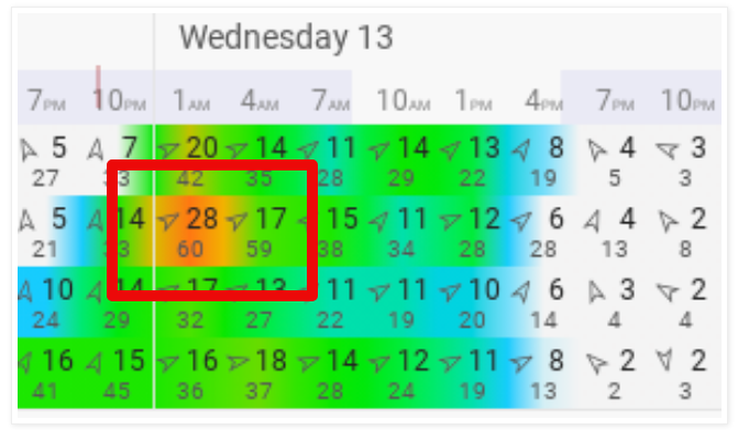
The graphic above shows pressure observations at Sea-Tac Airport from 11 PM Tuesday (12th) to 4 AM Wednesday (13th). Pressure rose from 1002.4 millibars to 1007.5 millibars in ONE HOUR!! A 5.1 millibar pressure rise in one hour is quite large, and will produce strong winds. That steep of a pressure rise is rare for Western Washington.

The largest pressure rises around the Puget Sound area happened between 12 and 1 AM on the 13th, directly causing the peak winds and hundreds of thousands of power outages.

2. What made this storm "unexpected" and why wasn't there a better forecast?

This storm was unexpected because it was relatively weak and wasn't picked up by most of the forecast models. Additionally, its fast development caused a strong pressure gradient which resulted in strong winds.

One forecast model (the European model) had a forecast for a rapidly developing storm with winds of 50-60 mph two days before it happened. However, because no other forecast predicted this, the European model was considered an "outlier."


Above is the blend of 4 forecast models for Puyallup that I posted on this blog just hours before the storm. The red outlined area is the European Model's forecast. While not perfect, it outlined the possibility of strong winds (50-65 mph) and predicted the storm's development perfectly, unlike the other models.

Seeing the European Model's prediction verifying as the storm developed on the evening of the 12th, forecasters at NWS Seattle issued a Wind Advisory at 8 PM, just 4-5 hours before the storm began. These forecasters did a great job seeing the developing storm and warning the public accordingly.

However, the relatively late warning of this storm led to most of the public being relatively unaware that a strong storm was coming until the strong winds hit. Thankfully, I was able to publish a blog about the storm (though I underestimated the winds) by 9:30 PM on the 12th.

3. Why was there so much damage and power outages?

A big impact of this windstorm was the large amount of power outages and tree damage especially due to saturated ground, something that had been predicted beforehand and was a big concern.

Our heavy rains in the previous weeks set the stage.


This graph from the Western Regional Climate Center shows that since January 1st, we have received 200-300% of our average rain (2-3 times the average) in Western Washington (totals of 5-9 inches for January so far).

Additionally, the graph below shows recent soil moisture levels.


When was the peak saturation in soils? You guessed it...midnight on the 13th, the same time as the peak winds.

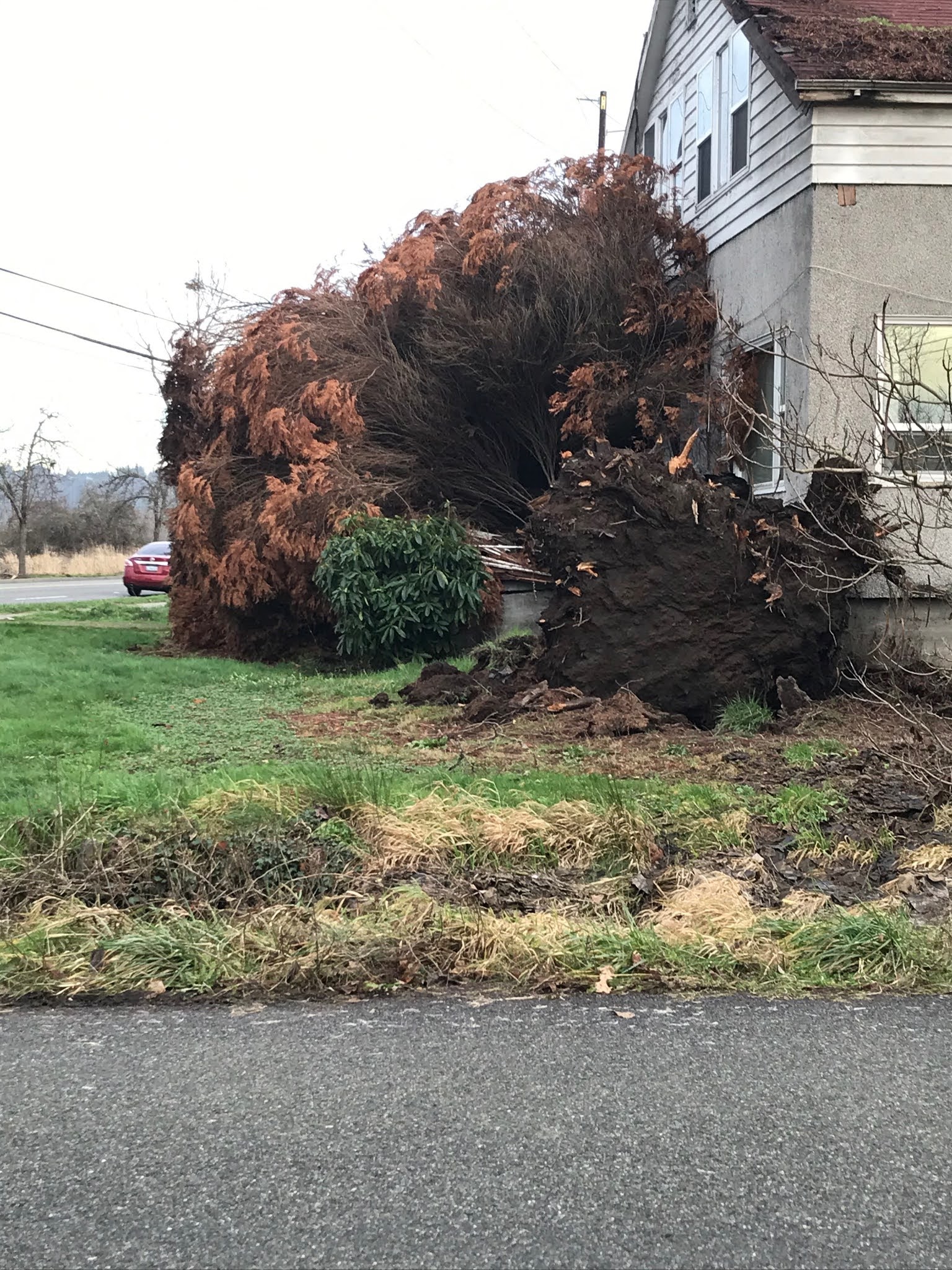
These factors above, combined with the 40-65 mph wind gusts in the Puget Sound area, were the main reasons for the large amount of power outages and storm damage from this windstorm, as seen below.

A downed tree (background) completely snapped a power pole in Sumner, WA. The pole was left leaning over the road, with power lines stuck in a downed tree.
Taken 1/13 by Don Neptun.

Fallen trees and downed power lines closed this road in front of the Sumner, WA YMCA.
Taken 1/13 by Don Neptun.

A tall power pole leans precariously over a closed street in Sumner, WA. 
Taken 1/13 by Don Neptun.

I would like to give a special thank you to Don Neptun for sending me these amazing photos of storm damage in Sumner, WA.

Those kind of scenes were common around Western Washington following the storm.

At the storm's peak, nearly 569,000 people were without power in Western Washington. 

This storm would go on to produce wind gusts of 60-120 mph across large areas of the Western & Central United States.

A map of damaging wind reports from January 13th-15th, made by the National Weather Service and featured by The Washington Post.

Wow! The storm's extent is revealed in that map, with hundreds of wind reports over many states.

4. What can we learn from this storm?

We can definitely take some lessons away from this windstorm. I've listed some below.

  1. It is always good to be prepared. Sometimes weather events happen with short notice. Have a way to receive weather alerts and be prepared for the impacts of strong winds and other hazardous weather.
  2. Large amounts of rain followed by strong winds will result in lots of damage. We already knew that this occurs, but it is a good reminder that shows what happens when heavy rain and strong winds combine.
  3. Don't count out a forecast model because its prediction is different than the others. While this mainly applies to meteorologists/weather enthusiasts, it is important to remember that a forecast isn't incorrect until the predicted event happens (or doesn't).
  4. Storms that strengthen as they make landfall are the strongest kinds and produce the biggest impacts. Also, a storm doesn't have to have a deep low pressure to pack strong winds, as we saw.

Thursday, January 14, 2021

Calm Weather, Switch To Cooler Pattern Upcoming

After a very stormy last few weeks, it’s calm! Some light rain is possible in the next few days.

Below, the UW model shows rain totals through 4 PM Sunday. 


Expect 0.1-0.7 inches of rain, most falling Thursday night/Friday and Saturday night/Sunday. 

Patchy fog is possible on Friday night into Saturday. It looks like Saturday will be a partly sunny day.

Besides this rain, no weather events are in the near future. However, a pattern switch to colder weather is likely starting on the 20th/21st.

Take a look at the 10 day forecast for Puyallup. Notice a switch to colder temperatures (especially low temps) around the 20th.


I’m sure you notice the snow icons showing up next week and beyond. Some forecasts have been showing a chance of snow, but no definitive predictions can be made at this time. 

It is likely that the Pacific Northwest will experience colder than average temperatures. The NOAA/NWS Climate Prediction Center graphic below shows temperature departure from average for January 22-28.


The graph shows a 60% chance of below average temperatures across Washington.

Stay tuned as details about this setup get clearer!

Upcoming blog post: “Analysis of the Strength & Impacts of the January 13th Windstorm”

Wednesday, January 13, 2021

Morning Update: Strong Windstorm Overnight

A strong windstorm associated with a compact low pressure area moved through Western Washington overnight, bringing wind gusts of 40-70 mph to the area.

Main Points as of 8:30 AM Wednesday:

  • Over 500,000 people have lost power in Western WA
  • Peak winds in the South Sound were 40-60 mph
  • Winds are subsiding and will continue to calm throughout the day
Also...today is likely a rain-free day! Enjoy that!!

Below are the peak gusts recorded around the area overnight.


This windstorm was a small, compact low center. The strongest winds were fueled by very steep rises in air pressure as the low center pulled away. 

Regarding the original forecast, this event was mainly underplayed. The European forecast model picked up on the strong winds 2 days in advance, but was considered an outlier. 

Seeing the potential for a fast-developing storm last night, the forecasters at NWS Seattle issued a Wind Advisory for 40-50 mph gusts at 8 PM Tuesday. 

The actual winds gusted 40-70 mph, strongest near the water and north of Everett. This included a strong westerly wind surge down the Strait of Juan de Fuca overnight, with gusts of 60-70 mph. High ground saturation also played a part in causing many power outages across the region.

Expect a dry day today and tomorrow, with a chance of rain on Thursday night.

A list of peak wind gusts can be found below.

(All readings from area weather stations, gusts could differ at your location relative to these)


Puyallup: 40 mph

Tacoma: 55 mph

JBLM: 58 mph

Waller: 53 mph

Federal Way: 61 mph

S. Federal Way: 47 mph

Auburn: 43 mph

Fox Island: 56 mph

Eatonville: 38 mph

Olympia: 47 mph

Des Moines: 54 mph

SeaTac: 58 mph

Seattle: 51 mph

SR-520 Bridge: 56 mph

West Point (Seattle): 59 mph

Bellevue: 52 mph

Renton: 48 mph

Bothell: 47 mph

Everett: 48 mph

Port Townsend: 65 mph

Whidbey Island: 64 mph

Mount Vernon: 56 mph

Friday Harbor: 54 mph

Bellingham: 70 mph

Chinook Pass: 106 mph

Crystal Mountain: 91 mph

Alpental Mountain: 121 mph

Stevens Pass: 56 mph

Mount Baker: 79 mph

Paradise: 66 mph


Tuesday, January 12, 2021

Tuesday Night Update: Windstorm Overnight, Rain Ending Wednesday

Tuesday has been a very rainy day, with 1-2.5 inches of rain across the Puget Sound area, bringing January to 5-8 inches total. Tuesday has also been quite balmy, with the subtropical air of the atmospheric river bringing temperatures of 52-58 degrees.

We're not out of the woods yet. A windstorm is likely overnight, and a Wind Advisory (posted below) has been issued from 10 PM Tuesday to 6 AM Wednesday.


Expect peak winds gusting 40-50 mph in the Puget Sound area. 

Typically, this storm wouldn't be too out-of-the-ordinary for us. However, with the large amounts of rain in the past few weeks and particularly the last few days, the ground is very saturated, and there is a higher possibility of tree damage and power outages.

The graphic below from AccuWeather shows the dangers of saturated soil.


Saturated soil will be a big factor in the impacts of this windstorm. Below is the blend of 4 forecast models for Puyallup. 


You probably see the 60 mph gust being forecast by one of the models. While winds that strong aren't likely, but be prepared for the small chance that winds will gust above 50 mph.

Expect peak winds between 11 PM Tuesday and 6 AM Wednesday. 

I'm sure that most everyone is done with rain by now, but we have a few more hours of rain until a break of more than 24 hours!

The UW Model below shows an additional 0.3-1.2 inches of rain through 4 PM Wednesday. This will contribute to the ongoing river, urban, and small stream flooding in Western Washington.


Our 24-hour rain totals ending 9:25 PM Tuesday are below. Let's just say it's been pretty wet.


All of this rain, and the large amounts (7-12 inches) of rain since late December has pushed soil moisture (and the landslide threat) to high levels. 

The antecedent water index is a measure of the landslide threat. A reading of 0.02 is categorized as "wet" conditions. Currently, area readings are 0.03-0.07, quite wet!

How to read this: Colored lines (key at bottom) are the Index readings. The yellow shaded area is the forecast. The graph runs from 12/29 to 1/14. The black line around 0.02 is the measurement of "wet" which is typically an increased landslide threat. As you can see, we are quite above that mark currently.

In short: there is a high threat of landslides in Western Washington, something that will continue for the next few days.

Snow levels in the mountains have risen over 5,000 feet, and there is a danger of avalanches due to heavy rain. Be safe if you're in the backcountry.

Also, another round of tidal overflow (0.5-1 foot) is likely Wednesday morning.

Blog Recap:

  • Winds gusting 40-50 mph (locally higher) are expected from 10 PM Tuesday to 6 AM Wednesday
  • Highly saturated soils will present a higher than normal threat of tree damage and power outages
  • An additional 0.3-0.6 inches of rain is possible through midday Wednesday (locally higher amounts possible)
  • A high landslide threat remains through the next few days
  • Mountain avalanche danger and minor tidal overflow is also likely on Wednesday


Monday, January 11, 2021

Monday Night Storm Update

It has been a rainy day across Western Washington as the atmospheric river begins impacting us. 24 hour rain totals as of 8:45 PM Monday are below.


Totals range from 0.4-1.2 inches, and an additional 1-2.5 inches are possible through Wednesday. 

Monday’s satellite image was incredible, showing the atmospheric river (plume of moisture) impacting us. The atmospheric river stretches thousands of miles all the way across the Pacific Ocean!


Those arrows aren’t actually there...but they show the incredible plume of moisture aimed at us. The air moving in to our area has gone from Japan, through the subtropical Pacific, and to our shores. While it brings us dreary weather, it’s amazing to see weather in action.

Due to all this rain, a Flood Watch (posted below) is in effect through Wednesday night.

Now that we know some of the impacts of the rain, let’s talk forecasts. The UW forecast model below shows precipitation through 4 PM Wednesday


Expect an additional 0.5-2.5 inches of rain. This will prompt urban, small stream, and river flooding, landslides, high soil moisture, and avalanche danger in the mountains.

Additionally, gusty winds are possible as well. Two timeframes of gusty winds are possible...Tuesday morning and Tuesday night/Wednesday morning.

Expect winds gusting 20-40 mph Tuesday morning and 25-45 mph Tuesday night into Wednesday morning.

Elevated soil moisture (in turn a very saturated ground) will cause an increased possibility of tree damage. 

For those along Puget Sound, there is also a chance of tidal overflow (up to 1 foot) due to king tides and low atmospheric pressure. Peak tidal overflow will likely occur between 5 and 6 AM Tuesday.

The graphic below from NWS Seattle shows our Monday to Wednesday rain forecast with impacts on the side.


One more thing...the “subtropical” component of the atmospheric river will bring highs of 52-57 degrees on Tuesday.

Be safe and try your best to stay dry!! We should have a break by Thursday!


Sunday, January 10, 2021

Atmospheric River Bringing Heavy Rain, Gusty Winds, Possible Flooding

The second full week of 2021 will start off quite wet, with an atmospheric river set to impact Western Washington during the first half of the week. Let's take a look at the details.

This 5-day outlook from NWS Seattle shows what to expect in the coming days.


The UW forecast model has some great tools to see the strength of atmospheric rivers that impact the Pacific Northwest.

Below is the integrated water vapor transport (IVT). This is basically the measure of water vapor being transported in the atmosphere. The forecast below is for 1 AM Tuesday.


Yellows, reds, and dark blues are higher values (key at bottom of image). At this time (1 AM Tuesday), a true atmospheric river is aimed at the Pacific Northwest. You can see the area of dense moisture stretching across the Pacific Ocean to our shores.

There will be two surges of strong and deep moisture. One is Monday night/Tuesday morning, with the second coming early Wednesday. They are both shown below.


These are potent atmospheric rivers that will bring a lot of rain to Western Washington. In addition, snow levels will rise above pass level on Monday night, leading to rain (5-10 inches), snowmelt, and avalanche danger in the mountains.

The GFS Model forecasts around 3 inches of rain for Western Washington through Wednesday evening. Expect the heaviest rain from Monday evening to Tuesday morning.


3-5 inches of rain in the lowlands by the end of this week is a good ballpark estimate. This will cause urban & small stream flooding, a high landslide threat, and possible river flooding.

In addition to the rain, gusty winds are possible as well. Expect wind gusts of 20-40 mph Monday night into Tuesday morning.

More wind, potentially stronger, is possible on Wednesday. It looks like we will have a drier day on Thursday.

Any winds will be worth watching due to the saturation of the soils producing a higher probability of tree damage.

Stay tuned & stay safe!

Friday, January 8, 2021

Relatively Calm Weekend Then Rain to Start Next Week

After localized gap winds and occasional rain on Friday, we will have a relatively calm weekend.

Saturday will start off chilly and foggy, with temperatures of 30-35 degrees and areas of fog around the region. (Graphic from NWS Seattle)


Due to the cold temperatures, there is also a chance of black ice and freezing fog on Saturday morning.

Where fog burns off, expect mostly sunny weather with highs in the 40s!

Another bout of easterly (from the east) gap winds in prone locations is expected Saturday through early Sunday morning. Expect the strongest winds in the outlined area (gusts 30-45 mph) and lesser winds (15-25 mph) in other foothill locations.


A system will bring occasional rain on Saturday night & Sunday morning. Expect only 0.05-0.2 inches of rain.

Sunday will be a day of scattered showers, with mostly cloudy conditions.

Starting Monday night, our next round of impactful rain will arrive. An atmospheric river (aka Pineapple Express) will bring heavy rain and higher snow levels to the Pacific Northwest. Due to this, a Hydrologic Outlook (below) has been issued by NWS Seattle.


The bottom line is that another round of rain that will elevate the landslide threat again and potentially bring flooding is on the way.

Details of rain amounts aren't yet certain, but a general idea is given by the Weather Underground forecast for Puyallup.


It looks like the heaviest rain (along with some possible gusty winds) will occur on Monday and Tuesday of next week. Temperatures will likely be mild (50s) all of next week.

Next week's forecast totals another 1-3 inches of rain in the lowlands, adding to the 2-5 inches of rain that has already fallen this month.


Short Spring Heat Wave for the Pacific Northwest

  FastCast--Thursday, May 9 to Tuesday, May 14: A spring "heat wave" is ahead for the Northwest, with the warmest temperatures see...