Monday, March 29, 2021

Spring Storm Recap, Dry Days & Cold Nights Ahead

A strong spring storm moved through Washington and most of the Pacific Northwest on Sunday and Monday. The storm brought strong winds, brief heavy rain, and some mountain snow.

Take a look at peak winds in the Lowlands and in Eastern Washington.


Winds gusted 30-50 mph in the Lowlands and 40-70 mph in Eastern WA, with isolated gusts of 70-100 mph.

Perhaps even more astounding is the incredible winds at Camp Muir (10,000 feet up on Mt. Rainier). Winds gusted over 100 mph for 12 HOURS, peaking with an astonishing reading of sustained 119 mph, gusting to 143 mph. That is the strength of a Category 3 hurricane.


Camp Muir is a very exposed location open to the full brunt of storms at a high altitude. It's rare to see such a strong gust (143 mph) anywhere, let alone in Washington State!

Monday was partly sunny, with light northerly winds bringing dry conditions and low relative humidity. Minimum humidity values are below.


Humidity dropped to 25-40%, low for this time of year.

Moving on from the storm, dry days with some unseasonably cold nights are expected. This graphic from NWS Seattle shows expected low temperatures on Tuesday morning.


Temperatures as low as the upper 20s are possible, especially in the South Sound. Additionally, there is a chance of patchy fog/freezing fog, frost, and black ice. Be prepared for these conditions!

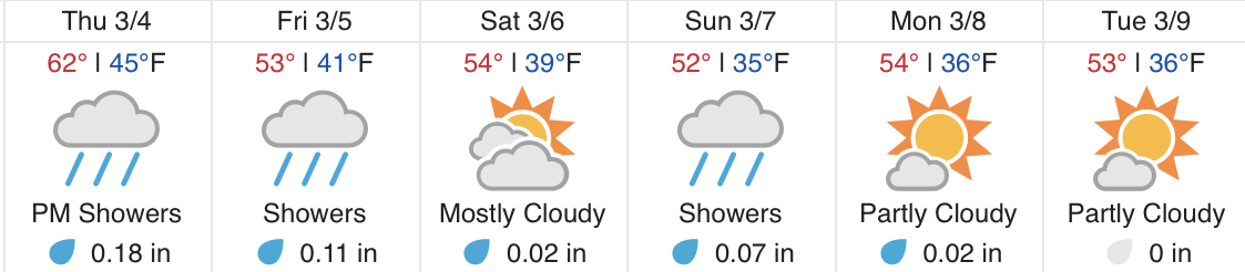
Looking ahead, here is the forecast for Puyallup from Weather Underground.


Temperatures gradually warm to the mid 60s on Wednesday (likely our warmest readings of 2021...yay!), with another chilly morning on Wednesday. We cloud up on Thursday, and showers return by Saturday.

Enjoy the calmer weather!


Saturday, March 27, 2021

Strong Spring Storm To Bring Strong Winds, Heavy Rain, and Mountain Snow

Updates 10:20 AM Sunday: Wind Advisory upgraded to include gusts of 50 mph for Interior Lowlands, new wind forecast for Puyallup, new Eastern WA wind graphic, and new UW rain forecast added with new 24-hr totals of 0.3-0.5 inches


On Sunday, a strong spring storm will impact Western Washington. The main hazards will be strong winds, heavy rain, and heavy mountain snow.

This graphic from NWS Seattle shows what to expect.

A Wind Advisory has been issued for 12 PM-6 PM on Sunday for SW winds 25-35 mph with gusts up to 50 mph.


The wind forecast for Puyallup is below. 

(Big numbers: sustained winds, small numbers: gusts, arrows: wind direction).


Forecast models agree on winds gusting 35-50 mph. Make sure to secure objects that could be blown around and be prepared for tree damage and isolated power outages.

Winds will surge through Eastern Washington as well, with gusts of 40-65 mph and blowing dust likely. This graphic below from NWS Spokane shows expected gusts on the eastern side of the state.

The winds are due to a strong cold front that will be moving through Washington on Sunday afternoon. This cold front will bring rain, heavy at times, on Sunday into early Monday morning. The expected rain totals through 5 AM Monday from the UW Model are below.


Expect 0.3-0.5 inches of rain on Sunday, with isolated higher totals.

Additionally, heavy mountain snow is expected on Sunday. This graphic from NWS Seattle shows how much accumulation to expect through Monday.


Snow levels will drop through the day on Sunday, dropping all the way to 500-1,000 feet by late Sunday night. A rain/snow mix is possible on higher hills as temperatures drop to the mid 30s behind the cold front.

There is also a chance of thunderstorms after the cold front (Sunday evening). Any heavy showers have could produce small hail, gusty winds, and potential lightning.

This cold front will have much colder air behind it. Take a look at the Puyallup forecast from Weather Underground.


Notice the chilly low temperatures from Sunday-Tuesday. Also...we will dry out with sunny weather all week, with highs up to 64 degrees on Thursday! Near freezing temperatures are possible on Monday and Tuesday mornings, so be prepared if you have plants. Rain returns by next weekend.


Thursday, March 25, 2021

Deadly Tornado Outbreak, SpaceX Rocket Burns Up Over Pacific Northwest

Just 8 days after a damaging tornado outbreak in the Deep South, another deadly outbreak occurred on Thursday (and is ongoing as of the writing of this blog).

Below is the severe weather outlook issued by the NWS Storm Prediction Center on Thursday morning.


Notice the high risk and moderate risk areas encompassing parts of Mississippi, Alabama, and Tennessee. Those areas had many severe thunderstorms and some damaging tornadoes. 

Sadly, as of Thursday night, 5 fatalities have occurred, all due to very strong tornadoes in Alabama. 

The very damaging nature of this outbreak was shown when over 3 tornado emergencies were issued in parts of the Deep South. The definition of a tornado emergency is below:

Tornado Emergency: An exceedingly rare tornado warning issued when there is a severe threat to human life and catastrophic damage from an imminent or ongoing tornado. This tornado warning is reserved for situations when a reliable source confirms a tornado, or there is clear radar evidence of the existence of a damaging tornado, such as the observation of debris.

A tornado emergency is very rare, and to have multiple tornado emergencies in one day shows the severity of this outbreak. This tornado outbreak will continue through late Thursday night (Pacific time). Below is a link to an article about the outbreak and its damage.

https://weather.com/news/news/2021-03-25-tornadoes-georgia-alabama-mississippi-tennessee-south

As this blog was written, a Tornado Emergency was issued for the area of Newnan, Georgia (about 35 mi SW of Atlanta).


You are able to see the damaging tornado on radar (outlined). The image on the right indicated a mile-wide area of debris lofted into the air by the tornado. Damage is likely, and sadly, nighttime tornadoes are the deadliest kind due to limited warning.

The City of Newnan confirmed "heavy damage" to their historic downtown area due to the tornado on their Twitter page.


—————————————————————————

Some of you might have heard about the SpaceX Falcon 9 Starlink rocket that burned up on re-entry into the atmosphere over Seattle and Portland around 9 PM PDT on Thursday. Some information is below:

https://www.king5.com/article/news/local/what-was-that-lights-streak-across-night-sky-in-washington/281-7470aba0-5de8-45a8-8bbb-4e1a806147d8


What an interesting and rare event! 

Expect dry days with highs in the 50s on Friday and Saturday! A potent frontal system will move into Western Washington on Sunday, bringing a return of rain & wind.


Tuesday, March 23, 2021

Next System To Bring Rain & Breezy Conditions On Wednesday

Tuesday was a dry day under a high pressure ridge. High clouds increased through the afternoon, a sign of an incoming weather system. Wednesday will bring rain and breezy conditions, along with some mountain snow.

The UW forecast model below shows a slight rain shadow over the Lowlands, with 0.1-0.3 inches of rain likely, but more possible in some spots.


Additionally, it will be breezy on Wednesday due to a front moving through. The wind forecast for Puyallup is below.


Expect gusts of 20-35 mph, mainly around midday.

This system will also bring some mountain snow, adding to the very plentiful snowpack.


The graphic above from NWS Seattle shows expected accumulations at the passes.

Let’s take a look at the upcoming days. Here’s the trusty Weather Underground forecast for Puyallup.


Wednesday is the rainiest day, with showers on Thursday, mainly in the morning. Expect mostly dry days on Friday and Saturday, then rain with the next brief system on Sunday. Dry conditions return on Monday.


Saturday, March 20, 2021

Rainy Pattern & Tornado Warnings on the Washington Coast?

Friday and Saturday were breezy and occasionally rainy, as forecast. Take a look at 48 hour rain totals ending 9 PM Saturday.


More rain is expected through the next few days. The forecast for Puyallup from Weather Underground shows expected conditions and rain accumulations.


Showers moving along the outside of a ridge will impact the area on Sunday and Monday. Expect a break Tuesday, then another system arrives for late Tuesday to early Thursday. At least a few days of drier and sunnier weather are possible beginning on Friday!

Now...to something interesting that occurred on Friday. A relatively deep low pressure system (by March standards) was offshore, and it kept pushing showers onshore. The setup is illustrated below. 


Due to instability in the atmosphere (cold temperatures aloft plus heating at the surface) these showers were convective and featured thunder, lightning, and some rotation. Three strong rotating showers moved onshore on the North WA Coast on Friday morning, prompting rare Tornado Warnings.

Below is a radar image showing one of these storm cells moving onshore between Forks and La Push. 


The thin red outline denotes a Tornado Warning. The orange outline is a Special Marine Warning, the marine equivalent of a Severe Thunderstorm Warning, (over 15 of these were issued off the WA/OR coasts on Friday due to strong thunderstorms). The circled area on the radar shows rotation and heavy rain.

Is this rare for Washington? Yes and no. Convective showers on the coast aren’t especially rare, but rotating convective showers with potential tornadoes and strong thunderstorms offshore are rare. We don’t see these warnings issued often around our area. 

No tornadoes have been confirmed as of the writing of this blog, but it’s interesting to see some tornado warnings in our neck of the woods.


Thursday, March 18, 2021

Windy Friday, Showers Through Next Week & Deep South Tornado Outbreak

Thursday featured some rain and occasionally breezy conditions across Western Washington. Winds will increase on Friday as a low pressure system skirts the coast, and showers will prevail for the next few days. Let’s get the details!

Friday will be windy. Take a look at the forecast below for Puyallup.


Winds gusting 30-45 mph are likely across the area, particularly from morning to evening on Friday. Expect winds to increase around or after 8 AM, peaking mid-afternoon, and decreasing through the night.

As always, some tree damage is possible, and be sure to secure objects that could be blown around by winds.

Taking a look at a longer-range forecast, expect showers through at least the middle of next week. (Puyallup forecast from Weather Underground)


Also notice the “chilly” high temperature on Sunday. We will likely stay below 50 degrees on Sunday, with near to slightly below average temperatures for the rest of the days.

Now to another weather event...there was a major tornado/severe weather outbreak on Wednesday across the Deep South. For the first time since 2019, the NOAA/NWS Storm Prediction Center issued a rare and dangerous high risk for severe weather. Wednesday’s severe weather threat map is below.


The red and pink colors (Moderate and High risks) are reserved for only the most dangerous events. An explanation of these risk categories is below.


You can see how the categories get progressively more dangerous, culminating with the high risk section. (The highest risk ever issued for Washington was an enhanced risk for severe thunderstorms in Eastern WA on May 30th, 2020.)

Below is a link to photos and information about Wednesday’s tornado outbreak. Please keep those impacted in your prayers.

https://weather.com/photos/news/2021-03-17-tornadoes-deep-south-photos

Be prepared for wind in Western Washington tomorrow!


Tuesday, March 16, 2021

Feet of Snow in the Recent Rockies Blizzard

Many of you have heard about the recent massive blizzard that quite literally buried portions of Colorado, Wyoming, South Dakota, and Nebraska. Particularly heavy amounts of snow were recorded in Wyoming and Colorado. 

Take a look at the NWS Boulder snowfall reports map from the storm. 


Compare the dots on the map to the legend. A whopping 24+ inches of snow was observed in many areas, including metropolitan Denver. Cheyenne, Wyoming got the most snow of any city, with a grand total of 30.8 inches (2nd all-time for the area).

This amount of snow was historic, and at the Denver Airport, 27.1 inches fell, making it the highest 3-day total since 1995 (see table below).


As you could imagine, this amount of snow had a major impact on the airport, closing all runways, resulting in the cancellation of hundreds of flights over a 2-day period.


So...what caused this massive amount snow? The answer is orographic precipitation. The graphic below shows this effect.


We are actually quite familiar with this effect here in Washington. The frequent rain shadows caused by the Olympic and Cascade Mountains are due to the orographic effect.

In the case of this recent blizzard, the prevailing winds were from a low center in the Central US. As the winds traversed the climbing foothills of the Rockies, the air condensed, resulting in the heavy precipitation, which due to cold temperatures, fell as heavy snow. Gusty winds didn't help the situation, as blizzard conditions were prevalent across much of the area during the storm.


Some excellent footage documenting the impacts of this winter storm can be found on the Live Storms Media YouTube Channel (click here). I highly recommend watching some of these videos!

Speaking of cold weather...Tuesday morning was unseasonably chilly in Western Washington, with lows in the upper 20s to low 30s. Expect another chilly morning on Wednesday, with lows of 28-34 degrees. The Puyallup Weather Underground forecast shows a good day Wednesday, then the return of rain by Thursday afternoon.


Sunday, March 14, 2021

Chance of Wintry Mix Sunday Night, Dry Until Thursday

Sunday has been a cool and rainy day, with 0.1-0.3 inches of rain across most of the area.

What a contrast from Saturday, which was the warmest day of 2021 so far, with widespread highs of 60-65 degrees. Observed high temperatures are below.


I hope you took advantage of the beautiful weather on Saturday! I took this photo in the Enumclaw area. 


Mount Rainier and our plentiful snowpack was on full display!

As the weather system moves out Sunday night into Monday, there is a chance of rain/snow mix or brief wet snow. Accumulations, if any, will be minimal with no impacts.

Looking ahead at the Puyallup forecast, partly cloudy conditions are likely through Wednesday. Highs warm up to the low 60s by Wednesday. Expect chilly mornings (lows 28-34 degrees) on Monday, Tuesday, and Wednesday.


Rain returns on Thursday as we enter a wetter pattern.


Friday, March 12, 2021

Large Temperature Contrast & Low Humidity On Friday, Rain Arrives Sunday

Friday was a beautiful day around the Puget Sound area, with plentiful sunshine!

You might have noticed a large temperature contrast throughout the day, with frost in the morning and warm sun in the afternoon.

Additionally, the afternoon was quite dry, with humidity plummeting to as low as 20%, the lowest we’ve seen since the fire weather/smoke event last September. Friday’s minimum humidity readings are below.


Humidity dropped to 15-40% around the region. If your throat was dry on Friday, this is why!

Taking a look at the Puyallup forecast from Weather Underground, we see that a nice day is in store for Saturday, with highs of 60+ degrees possible!


Be prepared for another chilly morning on Saturday, with lows of 28-35 degrees.

Expect increasing clouds through the day Saturday, and rain returns on Sunday. Dry weather returns for the start of next week. 

Also, Daylight Saving Time begins at 2 AM Sunday. This means we “spring forward.” Be sure to set your clocks to the correct time!

Wednesday, March 10, 2021

Beautiful Days Ahead!

We are heading for a couple beautiful days here in Western Washington! Below is a graphic from NWS Seattle showing expected weather for the next 5 days.


Thursday, Friday, and Saturday will be the best days in awhile, with warm temperatures and plenty of sun!

A key point is that it will be quite chilly in the mornings on Thursday and Friday, with lows dipping to the upper 20s/low 30s across most of the area.

Below is the Puyallup forecast from Weather Underground.


Rain returns by Sunday, but look at the great days ahead! Highs of 55-65 degrees are likely through Saturday! 

Any frost overnight and in the morning will thaw quickly with the warming temperatures. Be prepared for patchy morning fog on Thursday and Friday. If fog is present, it’ll burn off within a couple hours!

Enjoy the sunny weather!!

Monday, March 8, 2021

Mostly Dry With Chilly Nights This Week

Monday morning was quite chilly, especially for March in the Seattle area! Take a look at low temperatures on the graphic below.


Brrr! Low temperatures of 24-32 degrees were observed across the area. 

Monday was mostly cloudy, due to a weather system rotating offshore. 

In the UW forecast model below, you can see that rain showers don’t really make it to Puget Sound.


The Puget Sound area will receive light showers, mainly Monday night and Tuesday, totaling 0 to 0.05 inches.

Below is the Puyallup forecast from Weather Underground, showing partly-mostly sunny conditions this week, before showers return for the weekend.


Expect highs of 50-60 degrees (warmest on Friday), with morning lows of 30-35 degrees.

Frost is possible in the mornings this week, but expect it to thaw quickly as the temperatures warm in the mornings.


Saturday, March 6, 2021

Showers & Breezy On Sunday Then A Transition To Drier Weather

After a couple days of showers, periodically breezy conditions, and some sunbreaks, another weather system will move in on Sunday.

Rain will move in early Sunday morning, becoming scattered showers through the day Sunday. Below is the expected rain through 4 PM Monday from the UW model.


Expect light rain, totaling 0.05 to 0.25 inches. Notice that there’s “lines” of heavier rain on the map above. That shows that there will be heavier showers at times. 

There is also a chance of thunderstorms on Sunday, mainly from mid-morning to late afternoon. In any storm cell, be prepared for heavy rain, gusty winds, and potential hail and lightning.

Sunday will also be breezy. Below is the 4-model forecast for Puyallup.


Expect winds gusting 20 to 40 mph, mainly from early Sunday morning into the early evening. As always, some localized tree damage and isolated power outages are possible.

As showers and clouds move out of the area Sunday night, temperatures will drop into the low 30s. 


After the weather system moves out Sunday night, expect a nice week with little rain. High temperatures will be in the mid-upper 50s, with lows in the 30s. 

Some frost is possible in the mornings this week. Since we are getting into springtime, frost can impact plants that are starting to grow. Pay attention to forecast low temperatures if you’re growing plants. 

Wednesday, March 3, 2021

Rain Returns, Cooler Temperatures After Thursday

Wednesday was a beautiful day! It was mostly sunny with temperatures of 55-64 degrees. Take a look at the high temperatures below.


Before we get to Thursday’s weather...also take a look at Wednesday’s morning low temperatures, which reached the upper 20s-low 30s.

Thursday will be mostly cloudy, but southerly winds will warm the temperature to the upper 50s-low 60s across most of the area.

Rain will move in by Thursday evening, and the area will receive 0.2-0.75 inches of rain by 4 PM Saturday.


The most rain will fall Thursday night and Friday morning, and rain will continue (more showery) through at least the weekend.

Below is the Puyallup forecast from Weather Underground through the beginning of next week.


Temperatures reach 62 degrees on Thursday, cooling to the low-mid 50s for the rest of the timeframe.

Enjoy the warm day on Thursday!

Short Spring Heat Wave for the Pacific Northwest

  FastCast--Thursday, May 9 to Tuesday, May 14: A spring "heat wave" is ahead for the Northwest, with the warmest temperatures see...