Monday, August 29, 2022

Abnormal Late Summer Heat Wave & Some Smoke Aloft

Artemis I Update: NASA will hold a press conference at 3 PM PDT on Tuesday regarding the next steps with Artemis I. Find updates at NASA Twitter.

FastCast—Tuesday, Aug. 30 to Friday, Sep. 2:

An abnormal late summer heat wave is ahead for Washington State, with above normal temperatures through the remainder of the week. Highs in the lowlands will reach the upper 80s to low 90s on Tuesday and Wednesday, then cool slightly to the mid to upper 80s on Thursday and Friday. Lows will be in the upper 50s to low 60s. Expect highs to be cooler near the water, and expect areas of morning clouds on Tuesday and Thursday, with clouds increasing Friday evening. Eastern Washington will be sweltering, with highs all week in the mid 90s to mid 100s, hottest in the Columbia Basin. Daily high temperature records may be set at locations around the state. Beat the heat at the coast…where highs will only reach the mid 60s to low 70s! Additionally, light southerly flow (this makes it hot) will bring some upper-level wildfire smoke into the area. It won’t be heavy, but there will be a noticeable haze, especially on the horizon and when the sun is low. No impacts to air quality are expected in Western Washington. Stay tuned for more information about the heat and smoke.

———————————————————

Continue reading the full blog below!

The heat is sticking with us as we wrap up August and begin September. An amplifying (strengthening) ridge over the Pacific Ocean will deflect weather systems away from the Pacific Northwest and bring another heat wave this week. Let’s start with the NAM forecast for Tuesday’s highs.


Expect highs in the lowlands to be in the mid to upper 80s, with a chance of the traditionally hotter locations hitting 90 degrees. Sea-Tac Airport’s daily record of 88° will be given a run for its money! Light offshore flow will cause the coast to heat up to the low to mid 70s, hottest once you get inland from beach communities. Southwest Washington and the Portland area will reach the low to mid 90s, and Eastern Washington will reach the mid 90s to low 100s. 

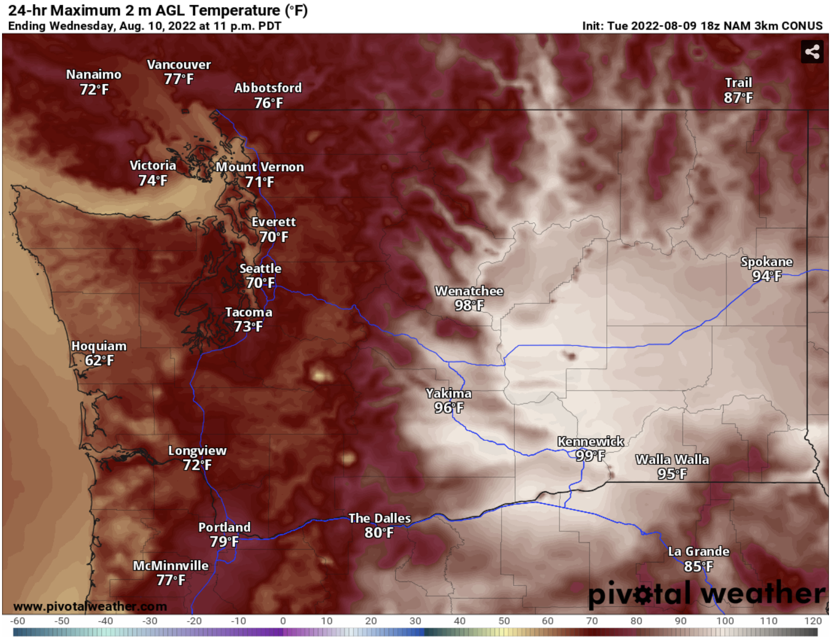
The lowlands will be even warmer on Wednesday, although there may be some clouds near the mountains and in parts of Eastern Washington due to subtle moisture that could produce a chance of mountain thunderstorms.

The European model forecast for Wednesday’s highs is below.


Expect highs in the upper 80s to near 90 in the lowlands. Add a couple degrees in the foothills and near Olympia and SW WA. Portland will again reach the low to mid 90s. Eastern Washington will be sweltering, with highs in the upper 90s to mid 100s. Kennewick’s forecast high of 105° is an astounding 18 degrees above average!

The departure from average is one way to see how abnormal a heat wave is. Below is the European model’s forecast for temperature departure from average on Wednesday afternoon.


The European model suggests that temperature anomalies around the Pacific Northwest will be in the neighborhood of 10-25 degrees above average on Wednesday. This heat is abnormal because we are reaching the point of the year that average temperatures begin decreasing toward fall temperatures. 

Initial forecasts for a midweek cooldown have changed, and it’s likely that highs in the mid to upper 80s will continue in the lowlands through Friday.

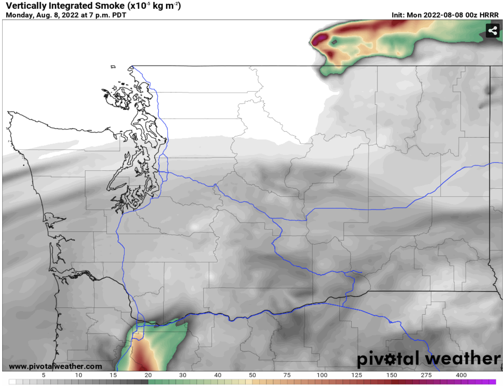
Due to the southerly flow that enhances heat in the Pacific Northwest, we will also introduce some wildfire smoke aloft into the forecast on Tuesday and Wednesday, and likely beyond.

Below is the HRRR smoke forecast for Tuesday afternoon.


Smoke aloft will be entering the area, producing a hazy sky, especially on the horizon. Smoke will increase in concentration on Wednesday, as seen below.


The Wednesday evening forecast shows smoke aloft over the entirety of Washington State, with some areas of moderate smoke concentrations. The only places where degraded air quality is possible will be higher elevations. Expect a hazy sky and some reddish-tinted sunsets.

Stay tuned for more information about the heat and smoke.

Sunday, August 28, 2022

Artemis I Launch Forecast: Will the Weather Cooperate for America's Return to the Moon?

Update Monday morning: NASA has scrubbed the launch of Artemis I due to technical issues. Launch is rescheduled to Friday. Stay tuned!

 FastCast-Monday, Aug. 29 to Friday, Sep. 2:

Another hot stretch is ahead for Western Washington. Mostly sunny conditions are expected all week, with a return of more clouds by Friday. Monday will be mostly sunny, with highs in the low 80s (upper 70s near the water). Tuesday and Wednesday will be the hottest days, with temperatures climbing into the upper 80s to near 90. The hottest day will be Wednesday, when the Lowlands have the best chance of reaching the low 90s. That will be most likely in the foothills and Olympia area. Thursday will be slightly cooler, with highs reaching the mid 80s, potentially the upper 80s in the normal hot spots. Friday will bring the return of partly cloudy conditions and onshore winds, with highs dropping to the low 80s. Lows all week will remain in the upper 50s, a sign that we are getting closer to fall. In Eastern Washington, expect another week of highs in the mid 90s to low 100s, hottest in the Columbia Basin. Keep reading below to find out if the weather is expected to cooperate for Monday morning's historic NASA Artemis I launch in Florida!

Watch live coverage: NASA YouTube Livestream

-----------------------------------------------------

Continue reading the full blog below!

On Monday, August 29th, from 8:30 to 10:30 AM Eastern Time (5:30-7:30 AM Pacific), the launch window is open for NASA's historic Artemis I launch, which will send NASA's largest rocket ever into space, eventually sending the Orion spacecraft on a 42-day orbit of the Moon. The Artemis I mission paves the way for America to return to the Moon for the first time in over 50 years...so it's quite a big deal! (Image: NASA)

We will use the two highest-resolution models available, the HRRR and NAM. The HRRR forecast for precipitation at the beginning of the launch window is below.


The Kennedy Space Center is located on Cape Canaveral, the area of land sticking out into the Atlantic Ocean between Palm Bay and Daytona Beach. The HRRR forecast shows showers getting quite close to Cape Canaveral, which could delay or cancel the launch. NASA rules state that launches can't happen through precipitation or within a certain distance of cumulus clouds that may contain lightning.

The NAM forecast also shows some showers near Cape Canaveral.


The NAM has showers closer to the coast moving toward Cape Canaveral. Showers and thunderstorms are often the biggest threat to launch, and it appears they will be a big factor with Artemis I.

Perhaps an even bigger threat to launch will be clouds. NASA rules state that if the flight path is within 5 nautical miles (5.7 mi) of clouds with freezing temperatures and/or moderate to heavy precipitation, launch must be delayed or canceled. Additionally, if the flight path is within 3 nautical miles (3.5 mi) of a thunderstorm for 3 hours, launch can't occur. 

Learn more about NASA's Artemis I launch rules by clicking here.

The HRRR forecast for cloud cover at the beginning of the launch window is below.


The HRRR shows 100% cloud cover at Cape Canaveral. This doesn't necessarily mean that it's a no-go for launch, but clouds could cause some problems. The thickness of the cloud layer and presence of large and tall cumulus clouds is what will delay or cancel the launch.

The NAM forecast below differs slightly.


The NAM forecast shows Cape Canaveral between areas of cloud cover, which is good and bad. It is good because it may help launch, but it is bad because breaks in the clouds can fuel showers and thunderstorms, which will delay or cancel launch.

As usual, it will come down to a last-minute decision. If launch is canceled on Monday, NASA says it can be rescheduled to Friday, September 2nd or Monday, September 5th (Labor Day). 

Friday, August 26, 2022

Weekend Chance of Rain, Next Hot Stretch Looming

FastCast—Saturday, Aug. 27 to Wednesday, Aug. 31:

Friday was substantially cooler than Thursday, with highs nearly 20 degrees below the previous day. The cool conditions will continue on Saturday, with highs in the low 70s around the region. A weak system moving through on Saturday will bring a chance of showers overnight and into the morning. The highest chance of rain is in the Puget Sound Convergence Zone, between Arlington and Seattle, where 0.1-0.25 inches of rain is possible. The Central Olympics and West Slopes of the Cascades may receive up to 0.75 inches of rain in isolated areas. Other parts of the lowlands will receive up to 0.1 inches of rain. Clouds will diminish on Sunday and Monday, with highs in the upper 70s to low 80s. Heat builds once again on Tuesday and Wednesday, with highs in the lowlands reaching the upper 80s, cooler near the water and warmer in the foothills. Eastern Washington will once again reach the upper 90s to mid 100s. The coast will be much cooler, in the 60s.

———————————————————

Continue reading the full blog below!

For the first time in weeks, there is a decent chance of rain in parts of Western Washington. The HRRR forecast for rain through 11 PM Saturday is below.


The HRRR forecast has consistently been on the lighter side for this rain, showing amounts of 0.01-0.05 inches, most in the mountains downwind of Convergence Zone bands (up to 0.2 inches). 

The NAM forecast has been showing much more rain through 11 PM Sunday, as seen below.


The NAM forecast shows 0.1-0.5 inches of rain on the coast and 0.25-0.75 inches (potentially more) in parts of the mountains. In this forecast, the Convergence Zone area between Seattle and Arlington receives 0.1-0.3 inches of rain, with other parts of the lowlands receiving up to 0.1-0.2 inches. 

However, this chance of rain and cool weather won’t last long. Temperatures rebound back to the upper 70s and low 80s with decreasing clouds on Sunday and Monday. Then, the next round of heat builds. Similar highs are expected on Tuesday and Wednesday (seen below from the European model).


Expect another couple days of lowland highs in the upper 80s, except cooler near the water. The Portland area and SW WA will reach the upper 80s to low 90s, and the coast will remain cool, in the 60s. It will be very hot again in Eastern Washington, with highs reaching the upper 90s to mid 100s. 

Enjoy a change in the weather and stay tuned for more information on the upcoming heat!

Wednesday, August 24, 2022

Hot Late August Day, Smoke Aloft, and the Big Cooldown

FastCast—Thursday, Aug. 25 to Monday, Aug. 29:

A hot day (by late August standards) is ahead on Thursday. Highs around the lowlands will reach the upper 80s to low 90s across Western Washington and the Willamette Valley. Eastern Washington will reach the upper 80s to upper 90s. There will be some smoke aloft in Western Washington (as there was on Wednesday) due to fires in British Columbia. There will be some surface smoke in the Cascades and in parts of Eastern Washington due to fires in BC and the Cascades. Air quality may suffer, but not greatly. A big cooldown is in store for Western Washington on Friday, with temperatures dropping into the low to mid 70s! It will be a dramatic change from Thursday. A slight chance of showers is possible on Saturday, with highs in the low 70s. Clouds decrease and temperatures rise back to the mid 70s on Sunday and then to the low 80s on Monday. Stay tuned for more information on the potential for weekend showers and another warmup next week.

————————————————————

Continue reading the full blog below!

An abnormally warm day is expected around Washington on Thursday. The NAM forecast for high temperatures is below.


Expect highs for most of Western Washington to be in the upper 80s to low 90s, except in the low 80s near the water. The coast will reach the low 60s to low 70s, and Eastern Washington will reach the upper 80s to upper 90s. This has been typical weather over the past few weeks, but with average highs around the mid 70s, temperatures in the low 90s are quite abnormal.

As there was on Wednesday, haze will be present aloft in Western Washington due to British Columbia wildfires. The HRRR smoke forecast at 12 PM Thursday is below.


While haze will be light, it will be noticeable, especially in the Bellingham area, closer to the wildfires. Light surface smoke with potential impacts to air quality is possible in Eastern Washington due to small fires in the Cascades. 

A big change is ahead on Friday, with temperature taking a big tumble to the 70s, as seen in the NAM forecast below.


On Friday, expect lowland highs in the low 70s, in the low 80s in the Willamette Valley, and in the 60s on the coast. However, temperatures will remain hot, reaching the low to mid 90s, except the upper 90s around the Tri Cities.

The 24-hour temperature change from 5 PM Thursday to 5 PM Friday in the NAM forecast below.


Temperatures will be 10-20 degrees cooler than Thursday in Western Washington, and a bit cooler in parts of Eastern WA as well.

Stay tuned for more information about a chance of showers on Saturday!

Monday, August 22, 2022

Another Heat Wave Ahead, Above Average Temps to Continue into September

 FastCast—Tuesday, Aug. 23 to Saturday, Aug. 27:

Another heat wave is in the forecast, as has been common this summer. A cooler day with morning clouds is expected on Tuesday, and highs will be in the upper 70s to low 80s, cooler than the past couple days. The heat arrives on Wednesday, with highs reaching the mid 80s to low 90s in the lowlands. Thursday will be the hottest day, with lowland highs in the upper 80s to mid 90s around the lowlands, hottest in the foothills. Lows on Thursday and Friday mornings will be in the low 60s. Much cooler weather arrives on Friday, with a return of partly cloudy conditions through Saturday. Highs will drop to the mid to upper 70s, a welcome break from the hot weather. In Eastern Washington, expect highs in the mid to upper 90s this week, nearing the low 100s in the Columbia Basin. Beat the heat at the coast…highs will only reach the mid 60s to low 70s!

————————————————————

Continue reading the full blog below!

The common theme of quick heat waves will continue. But first, a cooler day on Tuesday, with brief morning clouds. The Tuesday forecast is below from the NAM model.


Expect Tuesday’s highs to be in the upper 70s to low 80s. The coast will only reach the mid 60s to low 70s, and Eastern Washington will reach the low to mid 90s. 

Heat will build on Wednesday, and highs will increase to the mid 80s to low 90s around the lowlands. Thursday will be the hottest day, as seen below in the European model forecast.


Expect Thursday’s highs to be in the upper 80s to mid 90s around the lowlands. The foothills will be the hottest areas. Portland and SW WA will likely reach the mid 90s, and Eastern Washington will reach the low 90s to near 100. 

As mentioned in the FastCast above, temperatures will cool down on Friday and Saturday. However, temperatures will likely rebound next week and into the beginning of September. The NWS Climate Prediction Center outlook from August 30th to September 5th.


This forecast shows that there is a 50-80% chance of above average temperatures from late August to early September. It appears that the beginning and end of summer will be quite opposite…a cool beginning and a warm end. Stay tuned!

Friday, August 19, 2022

Very Muggy Conditions End, Next Heat Wave Ahead

FastCast—Saturday, Aug. 20 to Friday, Aug. 26:

After two uncharacteristically muggy days in Western Washington, more typical summer weather is ahead for the region through Tuesday, although temperatures will be slightly above average. Through Tuesday, expect lowland highs in the upper 70s to low 80s and lows in the upper 50s to low 60s, much more comfortable than the very warm lows on Thursday and Friday mornings. Conditions in Eastern Washington will remain hot, with highs in the 90s to near 100 in the Columbia Basin. The Coast will be the coolest area of the state, with highs in the upper 60s to near 70. No rain is forecast for the lowlands, but some light showers are possible on the coast and in the mountains on Saturday. Conditions change on Wednesday. The lowlands will endure another heat wave, with temperatures from Wednesday to Friday reaching the upper 80s to low 90s across the area, hottest away from the water. Thursday will be the hottest day, with a higher likelihood of 90°+ temperatures in the lowlands. Lowland lows during the heat wave will be in the low to mid 60s. In Eastern Washington, late week highs will again reach the upper 90s to low 100s. Note: Seattle only needs 2 day with highs above 90° to set a new all-time record for most 90°+ days in a summer.

————————————————————

Continue reading the full blog below!

Thursday and Friday were very odd days for Western Washington, particularly the Puget Sound Lowlands. These days were some of the muggiest days in recent memory for the area. Dewpoints reached the upper 60s to low 70s, incredibly rare for this region. Typical summer dewpoints are in the 50s, with dewpoints above the low 60s being relatively unusual. 

Take a look at the maps below, showing peak dewpoints on Thursday (top) and Friday (bottom).

The dewpoint is the temperature where dew would form on the grass. Higher dewpoints = less comfortable outside.


Friday offered a few degrees of improvement from Thursday, but it was still quite abnormal for the region. Dewpoints near or above 70 degrees are nearly unheard of in the Seattle area, and for such readings to be widespread for two days in a row is one of the most unusual weather phenomena to occur in this area.

Why did this happen? This was the combination of monsoon moisture from the Southwest that brought increased humidity and heat being trapped under the constant mid to high level clouds of the past couple days. It is an odd combination that doesn’t usually occur in the Northwest.

There is good news though…normal temperatures are ahead! The NAM forecast for Saturday shows near average temperatures for Western Washington.


Temperatures on Saturday will be near average for the lowlands, with highs reaching the mid to upper 70s. The coast will be in the 60s, and Eastern Washington will yet again be in the low 90s to near 100. Portland will reach the low 80s.

However, by the second half of next week, hot weather will return, with another heat wave in the forecast. The European model forecast below shows high temperatures on Thursday.


These are just preliminary, and Western Washington temperatures will likely end up higher than this forecast. Generally, highs in the mid 80s to low 90s can be expected from Wednesday to Friday. The Olympia and Portland areas will reach the upper 80s to mid 90s, and Eastern Washington will reach the mid 90s to low 100s. The coast will be the place to beat the heat…with highs likely in the upper 60s to low 70s.

The Climate Prediction Center outlook below shows a decent likelihood of above average temperatures for August 25-29.


With a 60-80% chance of above average temperatures over most of the Pacific Northwest, it is likely that temperatures in the 80s will continue for a bit after the next heat wave.

Stay tuned and enjoy a few days of more normal weather!

Wednesday, August 17, 2022

Update: Thursday Bringing Hot Weather & A Chance of Thunderstorms

No FastCast in this blog. Find the updated forecast at weather.gov and enter your location.

Thursday will be a hot day across the state, especially in Eastern Washington, where hazardous heat is expected. The HRRR forecast for temperatures at 4 PM Thursday are below.


Expect highs in the lowlands to reach the upper 80s to low 90s, except in the mid 80s near the water. The Vancouver BC/Bellingham area, the foothills, Portland area, and Olympia area will reach the mid 90s. Eastern Washington will be very hot, with highs in the low to mid 100s, and into the upper 100s in the Tri Cities area.

Higher than normal dewpoints due to monsoon moisture will bring a muggy feel to the air on Thursday. It will be mostly cloudy on Thursday as well, due to the monsoon moisture.

There is still a chance of thunderstorms on Thursday, mainly over the Cascades, Olympics, and Coast Range in Oregon. The UW forecast for CAPE (instability) is below.


Increased instability, with CAPE values of 200-1000, is expected in the Coast Range, Olympics, part of the Willamette Valley, and the Cascades. 

The NAM model is more aggressive with instability, as seen below.


The NAM shows the same areas of instability, just elevated. CAPE values on the NAM are in the 2000-4000 range in the mountains and the 500-1500 range in the lowlands. 

The bottom line is that there is a chance of thunderstorms, particularly over area mountains, on Thursday afternoon and evening. These thunderstorms will likely have little rain, and there is a high chance of potential fire starts. 

Stay tuned on Twitter and via the local news stations’ weather pages.

Wednesday Night Aurora Forecast: Cloud Cover Expected

No FastCast tonight...for updated forecasts, check weather.gov and enter your location.

There is chatter about a solar storm that could make it possible to view the Northern Lights from parts of Washington State late Wednesday night to early Thursday morning. However, as usual with celestial events in the Pacific Northwest, it all hinges on cloud cover. 

Below is the cloud cover forecast at 11 PM from the high-resolution NAM model.


This forecast is good news for aurora-watchers! The NAM suggests minimal cloud cover north of Tacoma and nearly none in Eastern Washington, except near Cle Elum and Ellensburg.

However, a forecast is not good unless it is from multiple sources. The latest cloud cover forecast from the HRRR high-resolution forecast for cloud cover at 11 PM is below.


The HRRR forecast seems to be more aligned with reality. The HRRR shows cloud cover across all of Western Washington except areas near Mount Vernon and north of Bellingham. Eastern Washington will have cloud cover on a line from the Tri Cities and Moses Lake westward.

GOES NOAA satellite imagery is below, and it seems to be trending closer to the HRRR forecast.


Notice all the clouds moving north into Washington. Those will likely obscure the view of the aurora for most of Western Washington and parts of Eastern Washington.

For more aurora information, check out the links below:

Tuesday, August 16, 2022

Short Heat Wave & A Chance of Thunderstorms Ahead

FastCast—Wednesday, Aug. 17 to Friday, Aug. 19:

An interesting couple days is ahead for the Pacific Northwest. On Wednesday and Thursday, expect hot weather around the area. Wednesday will have lowland highs in the mid to upper 80s, with some areas (likely east of I-5, the foothills, and the Olympia area) reaching the low 90s. Overnight lows will only reach the low to mid 60s. Thursday will be the hottest day, with temperatures in the lowlands reaching the low to mid 90s, hottest in the foothills and Olympia area. The Portland area will reach the upper 90s to low 100s, and Eastern Washington will reach the low to mid 100s, with isolated spots reaching the upper 100s. Lows in these areas will be in the mid 60s to mid 70s. Monsoon moisture will move north into the Pacific Northwest from Wednesday through early Friday. This will bring muggy and unstable conditions, with dewpoints in the low to mid 60s west of the Cascades and a chance of thunderstorms. The highest chance of thunderstorms will be in the Cascades on Wednesday afternoon and from Thursday afternoon through Friday morning. Very little (if any) rain is expected in these storms, elevating the fire risk, hence the Red Flag Warning in effect for the Cascades. There is a chance that a stray thunderstorm may move into the lowlands between Thursday afternoon and Friday evening. Stay tuned for more information and continue reading below!

—————————————————————

Continue reading the full blog below!

Interesting weather is ahead for the Pacific Northwest, with a brief heat wave and monsoon moisture impacting the region on Wednesday and Thursday. 

Let’s start with the heat. The HRRR forecast for Wednesday is below.


Expect lowland highs in the mid to upper 80s (cooler near the water). Portland and SW WA will reach the mid 90s to low 100s, and Eastern Washington will reach the upper 90s to mid 100s, hottest in the Columbia Basin. The coast will even reach the low 70s.

Expect more of the same on Thursday, just a few degrees hotter. The NAM forecast is below.


Expect Thursday’s highs to be in the low 90s around the lowlands, with the mid 90s in the foothills and near Olympia. Portland will hit the mid 90s as well. Eastern Washington will be scorching, in the upper 90s to mid 100s, with the Columbia Basin (Tri Cities area) reaching the upper 100s.

As we advance through Wednesday and into Thursday afternoon, monsoon moisture moving north will make its presence known. Muggy conditions are likely west of the Cascades, especially on Thursday. The NAM dewpoint forecast for Thursday afternoon is below.


Dewpoints across the lowlands will be in the low to mid 60s, with areas near the Cascades, SW WA, and the Willamette Valley pushing 70 degree dewpoints.

The combination of hot weather and high dewpoints will fuel a chance of thunderstorms both on Wednesday and Thursday. Wednesday’s chance will be more limited to the mountains, and there is a slightly better chance area-wide on Thursday. The forecast for CAPE (instability) values for Thursday from the UW model is below.


This forecast calls for CAPE values of 200-1000 across the Northwest, particularly in the Cascades, Willamette Valley, and SW WA.

The NAM forecast below is more aggressive with CAPE values.


The NAM shows high CAPE values of 2000-3500 over the Cascades, Olympics, and Oregon’s Coast Range on Thursday evening. Values of 500-2000 are noted over parts of the lowlands. This forecast has consistently shown high CAPE values, but it bears further watching as uncertainty always exists when forecasting thunderstorms in the Pacific Northwest.

There is one major downside to the potential thunderstorms on Wednesday and Thursday, as seen below in the NAM precipitation forecast through early Friday.


Barely any rain is expected to fall over the Cascades and most of Western Washington, except the coast. This means that any thunderstorms have a high possibility of being dry thunderstorms (when no rain falls), bringing a higher than normal fire danger. Due to this, NWS Seattle has issued a Red Flag Warning for the western slopes of the Cascades from Wednesday morning to Thursday night.

Due to the uncertainty of the upcoming situation, there will be an update Wednesday night. Stay tuned on Twitter & the blog!

Sunday, August 14, 2022

Next Heat Wave Arrives Midweek

FastCast—Monday, Aug. 15 to Friday, Aug. 19:

A couple cooler days are ahead to start the week before the next brief heat wave begins. Expect mostly sunny conditions on Monday and Tuesday, with highs in the low 80s and lows in the upper 50s. Heat builds on Wednesday and Thursday, with lowland highs reaching the mid 80s to low 90s. Lows will only reach the low to mid 60s. In Eastern Washington, highs will reach the upper 90s to mid 100s yet again through at least Friday. Areas of decreased air quality and wildfire smoke are possible in Eastern Washington due to fires in the area. On the coast, expect highs in the 60s with breezy northerly winds at times. Remember to take necessary heat-related precautions around the state, including staying inside or out of the sun during the hottest times.

——————————————————

Continue reading the full blog below!

Yet another run at 90 degrees is ahead for parts of Western Washington, with the hottest temperatures expected on Wednesday and Thursday. Before we get there, expect two near-average days on Monday and Tuesday. Monday’s highs are below from the NAM model.


Expect highs on Monday and Tuesday to be in the upper 70s to low 80s in the lowlands, the mid to upper 60s on the coast, and the low to mid 90s in Eastern Washington, except the upper 90s in the Tri Cities area.

The transition to the heat wave can be seen when comparing the UW upper-air forecast for Monday morning to the same forecast for Thursday. Monday morning is below.


On Monday morning, the Pacific Northwest will be between a low in the Gulf of Alaska and a high near Hawaii. 

By Thursday (below), the situation is much different.


By Thursday, high pressure dominates from the Southwest into the Inland Pacific Northwest. A low will be forming offshore from Oregon, but heat will be firmly entrenched over the Pacific Northwest.

Thursday will be the hottest day of this brief heat wave, as seen in the European model forecast below.


Expect Thursday to be quite hot. The lowlands will reach the mid 80s to low 90s, except the mid 90s in the foothills, Olympia area, and the Portland area. The coast will be cool, in the mid 60s to low 70s. Eastern Washington will be scorching once again, with highs in the upper 90s to mid 100s.

Remember to take heat-related precautions, especially if you are doing outdoor activities. 

Above average temperatures will continue for the next couple weeks, as seen in the Pivotal Weather/CPC climate outlook below for August 20-24.


There is a 60-90% chance of above average temperatures over the Pacific Northwest, meaning that it is likely that warm conditions (80+ degree highs) will continue for some time.

Stay tuned for more information about upcoming heat!

Tuesday, August 9, 2022

Area-Wide Chance of Thunderstorms & Much Cooler on Wednesday

 FastCast—Wednesday, Aug. 10 to Saturday, Aug. 13:

An interesting weather situation is ahead, with an area-wide chance of thunderstorms due to monsoonal moisture moving north into the Pacific Northwest. It will also be the coolest day of the week, especially in Western Washington, where highs in the lowlands will only reach the upper 60s to low 70s. Showers will move from south to north from very early Wednesday morning through early afternoon. With high instability (CAPE values) throughout the region, any shower could become a thunderstorm. There is also a chance of severe thunderstorms in Eastern Washington on Wednesday. There is a risk of dry thunderstorms and dry lightning strikes over the west slopes of the Olympics and the entirety of the North Cascades, meaning that there will be an increased risk of wildfires. A Red Flag Warning has been issued for these areas on Wednesday. Total rain will be highly dependent on the locations of showers, but under the showers, expect 0.1-0.3 inches of rain. From Thursday to Saturday, expect highs in the upper 70s to low 80s, with morning clouds and afternoon sun. Continue reading below for more information about thunderstorms on Wednesday! Remember, “when thunder roars, go indoors” and stay inside for at least 30 minutes after you last hear thunder.

——————————————————

Continue reading the full blog below!

Moisture from the Southwest Monsoon will move into the Pacific Northwest on Wednesday, bringing a chance of thunderstorms to the entire region.

The highest instability (CAPE values) will be on the coast and in the Cascades, especially the North Cascades. Eastern Washington will also have a high chance of thunderstorms. Instability on the map doesn’t necessarily mean that storms will be present, but there is a higher opportunity. The UW forecast for CAPE (instability) at 11 AM Wednesday is below.


The highest instability will be on the coast and over the Cascades and Olympics, but in the afternoon. 

Thunderstorms on Wednesday will bring 2 main hazards to the Pacific Northwest. The first is the marginal risk of severe thunderstorms for Eastern Washington, as seen below.


This risk area includes population centers like Spokane, the Tri-Cities, Ellensburg, and Wenatchee. In the risk area, there is a higher chance for strong thunderstorms, 1+” hail, and 58+ mph wind gusts.

Another threat is dry thunderstorms. Because it is summer, it can be harder for rain to reach the ground, so there is no rain to immediately extinguish lightning-started fires. Additionally, thunderstorm outflow winds can cause fires to spread fast. Due to this, a Red Flag Warning has been issued for the areas highlighted in bright red below.

NWS Seattle is warning for a high fire risk on the west slopes of the Olympics and in the North Cascades, and NWS Portland is warning of a high fire risk for the east Coast Range, the entire Willamette Valley, and the west slopes of the Cascades.

Remember that a fire risk exists even if you are outside the Red Flag Warning zones. Any thunderstorm can be a dry thunderstorm, so be vigilant!

Rain will be highly dependent on where showers set up. The UW forecast for rain through 5 PM Wednesday is below.


As explained earlier, the rain will be quite sporadic, with a higher chance near the coast. Generally, expect 0-0.15 inches in the lowlands and up to 0.25-0.3 inches on the coast and in the Olympics. 

One more thing about Wednesday…it will be much cooler than the past few days. The high temperature forecast is below, from the NAM model.


Expect a cool day, with lowland highs reaching the upper 60s to low 70s. The same cannot be said for Eastern Washington, where highs will again reach the mid to upper 90s.

A good way to see weather updates is to follow local meteorologists on Twitter. Michael Snyder (@SeattleWXGuy) is a good one to follow. Also, stay tuned to the radar feature on your weather app. Radar can also be found at radar.weather.gov.

Sunday, August 7, 2022

Brief Heat Wave Continues, Changes Ahead

This is Blog Post #400 on The_Weatherman2 Weather Blog!! Thank you for following along!

FastCast—Monday, Aug. 8 to Friday, Aug. 12:

The short heat wave currently impacting the Pacific Northwest will continue on Monday, with temperatures again reaching the mid 80s to low 90s, as they did on Sunday. The coast will be much cooler, with highs in the low to mid 60s, after reaching the mid to upper 80s on Sunday. It will be different story in Eastern Washington, with temperatures reaching the mid to upper 90s, except the low to mid 100s in the Columbia Basin. Most of Washington state will be impacted by light smoke aloft for the next couple days, with some surface smoke at times in Eastern Washington. A change is ahead from late Tuesday through Wednesday morning. A low pressure system offshore will push showers through Western Washington (stay tuned for updates on the chance of thunderstorms), bringing 0.1-0.2 inches of rain to most of the area. Temperatures will drop to the low to mid 70s in Western Washington and back down to the upper 80s to mid 90s in Eastern Washington. Western Washington will have temperatures rebound with sunnier conditions on Thursday and Friday. Temperatures in the lowlands will reach the low 80s, and will reach the mid 60s on the coast. It will be back to the 90s in Eastern Washington.

—————————————————————————

Continue reading the full blog below!

The brief heat wave will continue on Monday, with another day of highs in the mid 80s to low 90s for most of the lowlands. The NAM model forecast for Monday is below.

This forecast tends to be 2-3 degrees too cool for Western Washington. Generally, expect highs in the lowlands to be in the mid 80s to low 90s, except in the low to mid 60s on the coast. Eastern Washington will be scorching, in the upper 90s to mid 100s. Portland and SW WA will be in the upper 80s to low 90s. 

Most of you probably noticed the increasing haziness in the sky on Sunday. That is due to wildfire smoke from a combination of fires in California, Oregon, and Eastern Washington. The HRRR forecast for smoke aloft on Monday evening is below.


Smoke will be increasing on Monday evening, and a denser plume of smoke (seen in Northern Oregon in this graphic) will move through Western Washington overnight.

By Tuesday afternoon, the effects of continuous southerly flow will be noticeable, as smoke aloft moves through the area in a constant stream because of winds from the south.


By Wednesday evening, haze will be present over most of the state. This will not impact air quality in Western Washington, but some surface smoke will bring decreased air quality at times in Eastern Washington.

A change is ahead…with a low pressure system moving through the region from late Tuesday night through Wednesday morning. This system will bring a decrease in temperatures across Washington, along with a chance of rain and thunderstorms west of the mountains.

The UW forecast below shows expected rain through Wednesday evening.


Notice how to highest totals are in narrow lines. This shows that the rain will likely be confined to stronger showers, not a large area of precipitation (called stratiform rain). Totals of 0.1-0.2 inches are likely in the lowlands, and up to 0.5” in the Olympics.

Now for the interesting part…a chance of thunderstorms from very early Wednesday morning through early afternoon. The UW forecast for CAPE (instability) at 8 AM Wednesday is below.


This forecast shows CAPE values of 400-600 in the lowlands, and 600-800 in the mountains. Stay tuned for updates on the area-wide chance of thunderstorms on Wednesday.

Highs for Sunday are below. It was quite warm for those attending Seafair Sunday! Also, note the big impact that offshore flow has on temperatures at the coast (up to the upper 80s), and the fact that the Portland area was a tad bit hotter than the Columbia Basin.


Short Spring Heat Wave for the Pacific Northwest

  FastCast--Thursday, May 9 to Tuesday, May 14: A spring "heat wave" is ahead for the Northwest, with the warmest temperatures see...