FastCast—Monday, Aug. 15 to Friday, Aug. 19:
A couple cooler days are ahead to start the week before the next brief heat wave begins. Expect mostly sunny conditions on Monday and Tuesday, with highs in the low 80s and lows in the upper 50s. Heat builds on Wednesday and Thursday, with lowland highs reaching the mid 80s to low 90s. Lows will only reach the low to mid 60s. In Eastern Washington, highs will reach the upper 90s to mid 100s yet again through at least Friday. Areas of decreased air quality and wildfire smoke are possible in Eastern Washington due to fires in the area. On the coast, expect highs in the 60s with breezy northerly winds at times. Remember to take necessary heat-related precautions around the state, including staying inside or out of the sun during the hottest times.
——————————————————
Continue reading the full blog below!
Yet another run at 90 degrees is ahead for parts of Western Washington, with the hottest temperatures expected on Wednesday and Thursday. Before we get there, expect two near-average days on Monday and Tuesday. Monday’s highs are below from the NAM model.
Expect highs on Monday and Tuesday to be in the upper 70s to low 80s in the lowlands, the mid to upper 60s on the coast, and the low to mid 90s in Eastern Washington, except the upper 90s in the Tri Cities area.
The transition to the heat wave can be seen when comparing the UW upper-air forecast for Monday morning to the same forecast for Thursday. Monday morning is below.
On Monday morning, the Pacific Northwest will be between a low in the Gulf of Alaska and a high near Hawaii.
By Thursday (below), the situation is much different.
By Thursday, high pressure dominates from the Southwest into the Inland Pacific Northwest. A low will be forming offshore from Oregon, but heat will be firmly entrenched over the Pacific Northwest.
Thursday will be the hottest day of this brief heat wave, as seen in the European model forecast below.
Expect Thursday to be quite hot. The lowlands will reach the mid 80s to low 90s, except the mid 90s in the foothills, Olympia area, and the Portland area. The coast will be cool, in the mid 60s to low 70s. Eastern Washington will be scorching once again, with highs in the upper 90s to mid 100s.
Remember to take heat-related precautions, especially if you are doing outdoor activities.
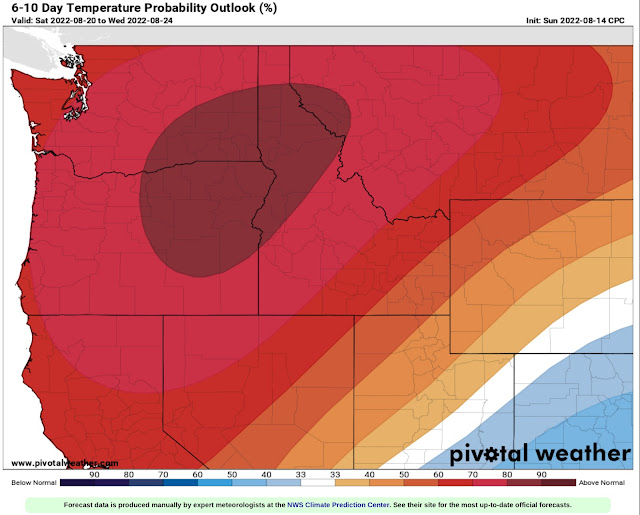
Above average temperatures will continue for the next couple weeks, as seen in the Pivotal Weather/CPC climate outlook below for August 20-24.
There is a 60-90% chance of above average temperatures over the Pacific Northwest, meaning that it is likely that warm conditions (80+ degree highs) will continue for some time.
Stay tuned for more information about upcoming heat!


No comments:
Post a Comment