Artemis I Update: NASA will hold a press conference at 3 PM PDT on Tuesday regarding the next steps with Artemis I. Find updates at NASA Twitter.
FastCast—Tuesday, Aug. 30 to Friday, Sep. 2:
An abnormal late summer heat wave is ahead for Washington State, with above normal temperatures through the remainder of the week. Highs in the lowlands will reach the upper 80s to low 90s on Tuesday and Wednesday, then cool slightly to the mid to upper 80s on Thursday and Friday. Lows will be in the upper 50s to low 60s. Expect highs to be cooler near the water, and expect areas of morning clouds on Tuesday and Thursday, with clouds increasing Friday evening. Eastern Washington will be sweltering, with highs all week in the mid 90s to mid 100s, hottest in the Columbia Basin. Daily high temperature records may be set at locations around the state. Beat the heat at the coast…where highs will only reach the mid 60s to low 70s! Additionally, light southerly flow (this makes it hot) will bring some upper-level wildfire smoke into the area. It won’t be heavy, but there will be a noticeable haze, especially on the horizon and when the sun is low. No impacts to air quality are expected in Western Washington. Stay tuned for more information about the heat and smoke.
———————————————————
Continue reading the full blog below!
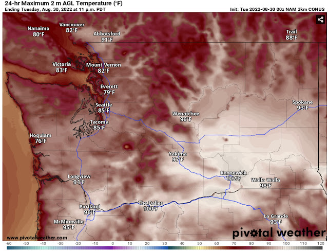
The heat is sticking with us as we wrap up August and begin September. An amplifying (strengthening) ridge over the Pacific Ocean will deflect weather systems away from the Pacific Northwest and bring another heat wave this week. Let’s start with the NAM forecast for Tuesday’s highs.
Expect highs in the lowlands to be in the mid to upper 80s, with a chance of the traditionally hotter locations hitting 90 degrees. Sea-Tac Airport’s daily record of 88° will be given a run for its money! Light offshore flow will cause the coast to heat up to the low to mid 70s, hottest once you get inland from beach communities. Southwest Washington and the Portland area will reach the low to mid 90s, and Eastern Washington will reach the mid 90s to low 100s.
The lowlands will be even warmer on Wednesday, although there may be some clouds near the mountains and in parts of Eastern Washington due to subtle moisture that could produce a chance of mountain thunderstorms.
The European model forecast for Wednesday’s highs is below.
Expect highs in the upper 80s to near 90 in the lowlands. Add a couple degrees in the foothills and near Olympia and SW WA. Portland will again reach the low to mid 90s. Eastern Washington will be sweltering, with highs in the upper 90s to mid 100s. Kennewick’s forecast high of 105° is an astounding 18 degrees above average!
The departure from average is one way to see how abnormal a heat wave is. Below is the European model’s forecast for temperature departure from average on Wednesday afternoon.
The European model suggests that temperature anomalies around the Pacific Northwest will be in the neighborhood of 10-25 degrees above average on Wednesday. This heat is abnormal because we are reaching the point of the year that average temperatures begin decreasing toward fall temperatures.
Initial forecasts for a midweek cooldown have changed, and it’s likely that highs in the mid to upper 80s will continue in the lowlands through Friday.
Due to the southerly flow that enhances heat in the Pacific Northwest, we will also introduce some wildfire smoke aloft into the forecast on Tuesday and Wednesday, and likely beyond.
Below is the HRRR smoke forecast for Tuesday afternoon.
Smoke aloft will be entering the area, producing a hazy sky, especially on the horizon. Smoke will increase in concentration on Wednesday, as seen below.
The Wednesday evening forecast shows smoke aloft over the entirety of Washington State, with some areas of moderate smoke concentrations. The only places where degraded air quality is possible will be higher elevations. Expect a hazy sky and some reddish-tinted sunsets.
Stay tuned for more information about the heat and smoke.


No comments:
Post a Comment