FastCast—Tuesday, Aug. 23 to Saturday, Aug. 27:
Another heat wave is in the forecast, as has been common this summer. A cooler day with morning clouds is expected on Tuesday, and highs will be in the upper 70s to low 80s, cooler than the past couple days. The heat arrives on Wednesday, with highs reaching the mid 80s to low 90s in the lowlands. Thursday will be the hottest day, with lowland highs in the upper 80s to mid 90s around the lowlands, hottest in the foothills. Lows on Thursday and Friday mornings will be in the low 60s. Much cooler weather arrives on Friday, with a return of partly cloudy conditions through Saturday. Highs will drop to the mid to upper 70s, a welcome break from the hot weather. In Eastern Washington, expect highs in the mid to upper 90s this week, nearing the low 100s in the Columbia Basin. Beat the heat at the coast…highs will only reach the mid 60s to low 70s!
————————————————————
Continue reading the full blog below!
The common theme of quick heat waves will continue. But first, a cooler day on Tuesday, with brief morning clouds. The Tuesday forecast is below from the NAM model.
Expect Tuesday’s highs to be in the upper 70s to low 80s. The coast will only reach the mid 60s to low 70s, and Eastern Washington will reach the low to mid 90s.
Heat will build on Wednesday, and highs will increase to the mid 80s to low 90s around the lowlands. Thursday will be the hottest day, as seen below in the European model forecast.
Expect Thursday’s highs to be in the upper 80s to mid 90s around the lowlands. The foothills will be the hottest areas. Portland and SW WA will likely reach the mid 90s, and Eastern Washington will reach the low 90s to near 100.
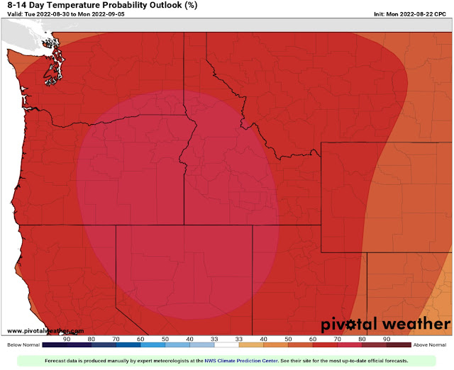
As mentioned in the FastCast above, temperatures will cool down on Friday and Saturday. However, temperatures will likely rebound next week and into the beginning of September. The NWS Climate Prediction Center outlook from August 30th to September 5th.
This forecast shows that there is a 50-80% chance of above average temperatures from late August to early September. It appears that the beginning and end of summer will be quite opposite…a cool beginning and a warm end. Stay tuned!


No comments:
Post a Comment