FastCast—Wednesday, Aug. 10 to Saturday, Aug. 13:
An interesting weather situation is ahead, with an area-wide chance of thunderstorms due to monsoonal moisture moving north into the Pacific Northwest. It will also be the coolest day of the week, especially in Western Washington, where highs in the lowlands will only reach the upper 60s to low 70s. Showers will move from south to north from very early Wednesday morning through early afternoon. With high instability (CAPE values) throughout the region, any shower could become a thunderstorm. There is also a chance of severe thunderstorms in Eastern Washington on Wednesday. There is a risk of dry thunderstorms and dry lightning strikes over the west slopes of the Olympics and the entirety of the North Cascades, meaning that there will be an increased risk of wildfires. A Red Flag Warning has been issued for these areas on Wednesday. Total rain will be highly dependent on the locations of showers, but under the showers, expect 0.1-0.3 inches of rain. From Thursday to Saturday, expect highs in the upper 70s to low 80s, with morning clouds and afternoon sun. Continue reading below for more information about thunderstorms on Wednesday! Remember, “when thunder roars, go indoors” and stay inside for at least 30 minutes after you last hear thunder.
——————————————————
Continue reading the full blog below!
Moisture from the Southwest Monsoon will move into the Pacific Northwest on Wednesday, bringing a chance of thunderstorms to the entire region.
The highest instability (CAPE values) will be on the coast and in the Cascades, especially the North Cascades. Eastern Washington will also have a high chance of thunderstorms. Instability on the map doesn’t necessarily mean that storms will be present, but there is a higher opportunity. The UW forecast for CAPE (instability) at 11 AM Wednesday is below.

The highest instability will be on the coast and over the Cascades and Olympics, but in the afternoon.
Thunderstorms on Wednesday will bring 2 main hazards to the Pacific Northwest. The first is the marginal risk of severe thunderstorms for Eastern Washington, as seen below.

This risk area includes population centers like Spokane, the Tri-Cities, Ellensburg, and Wenatchee. In the risk area, there is a higher chance for strong thunderstorms, 1+” hail, and 58+ mph wind gusts.
Another threat is dry thunderstorms. Because it is summer, it can be harder for rain to reach the ground, so there is no rain to immediately extinguish lightning-started fires. Additionally, thunderstorm outflow winds can cause fires to spread fast. Due to this, a Red Flag Warning has been issued for the areas highlighted in bright red below.

Remember that a fire risk exists even if you are outside the Red Flag Warning zones. Any thunderstorm can be a dry thunderstorm, so be vigilant!
Rain will be highly dependent on where showers set up. The UW forecast for rain through 5 PM Wednesday is below.

As explained earlier, the rain will be quite sporadic, with a higher chance near the coast. Generally, expect 0-0.15 inches in the lowlands and up to 0.25-0.3 inches on the coast and in the Olympics.
One more thing about Wednesday…it will be much cooler than the past few days. The high temperature forecast is below, from the NAM model.
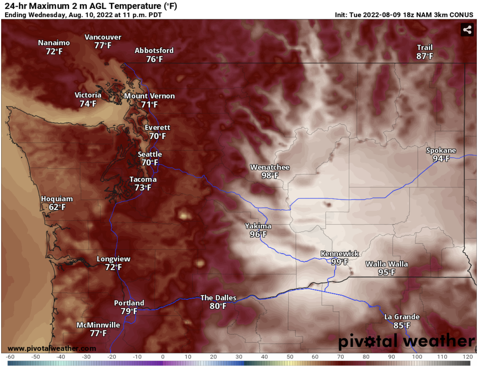
Expect a cool day, with lowland highs reaching the upper 60s to low 70s. The same cannot be said for Eastern Washington, where highs will again reach the mid to upper 90s.
A good way to see weather updates is to follow local meteorologists on Twitter. Michael Snyder (@SeattleWXGuy) is a good one to follow. Also, stay tuned to the radar feature on your weather app. Radar can also be found at radar.weather.gov.

No comments:
Post a Comment