Sunday, July 31, 2022

Gradual Cooldown Begins After Major Heat Wave

FastCast—Monday, Aug. 1 to Friday, Aug. 5:

After an all-time record 6 consecutive days at 90+ degrees in Seattle, this weeklong heat wave will gradually come to an end. Expect Monday’s highs in the lowlands to be in the low to mid 80s. In Eastern Washington, relief will be virtually nonexistent, with highs reaching the mid 90s to low 100s on Monday and Tuesday, before finally cooling to the mid 80s to low 90s after that. Back to the lowlands…Tuesday through Friday will be in the mid to upper 70s, a huge relief after this heat wave. Expect overnight lows in the mid to upper 50s, seasonable for August. Additionally, clouds will return for the first time in over a week due to the return of onshore flow. Expect morning clouds every day except Friday. On Friday, flow turns northerly, eliminating most clouds. We will make another (potentially extended) run into the 80s starting next Saturday.

————————————————————

Continue reading the full blog below!

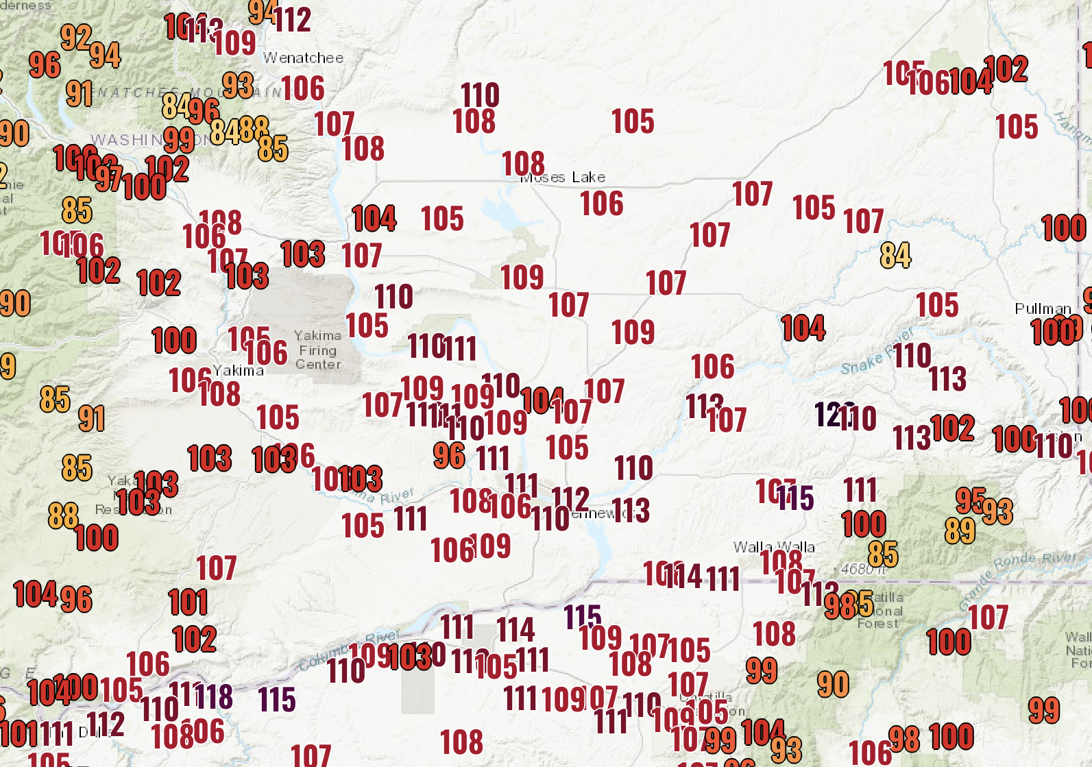
From many individual records to Seattle’s longest stretch above 90 degrees, this was a significant heat wave for the Pacific Northwest. It will be remembered not for its temperature values, but for its longevity. It will try and hold on a bit longer than previously anticipated, especially in Eastern Washington. Let’s take a look at the forecast.

The HRRR high-resolution forecast for Monday is below, showing approximate high temperatures.


Expect highs in the low to mid 80s in the lowlands, coolest near the Sound and hottest east of I-5. The Portland area will reach the mid 80s to low 90s. Eastern Washington will continue baking, with highs in the mid 90s to mid 100s yet again. This heat wave has been quite bad for Western Washington, and just plain brutal on the east side of the mountains, with the Tri Cities Airport reaching 100+ degrees for 8 consecutive days, with 2-3 more days above 100 degrees ahead.

Western Washington will really feel the marine influence on Monday evening and through the night. Take a look at the NAM forecast for lows on Tuesday morning.


Lows in Western Washington will reach the upper 50s to low 60s, the coolest in nearly a week. Even Eastern Washington will be a bit cooler, with lows dropping to the upper 60s to low 70s, after a week with lows as high as 80 degrees.

Tuesday will finally be a near-average summer day in Western Washington, as seen in the NAM forecast below.


Expect lowland highs in the upper 60s near the water and the mid to upper 70s in the interior! Eastern Washington will continue gradually cooling down, with highs in the low 90s to low 100s. Portland will drop to the mid 80s.

Stay tuned for more information on the seasonable weather ahead and the potential chance of some showers in Western Washington later this week. You can find Sunday’s high temperatures below.

Information about the explosive McKinney Fire near Klamath River, California (near the CA/OR border, west of Yreka) can be found below:

McKinney Fire InciWeb Page

Sunday High Temperatures:


Friday, July 29, 2022

Heat Wave Persists Through the Weekend

FastCast—Saturday, July 30 to Monday, Aug. 1:

Only 2 more days of hot temperatures remain in Western Washington. It has been a brutal stretch for many residents, with highs above 90 degrees since Tuesday (approaching a record…details below). As forecasts now indicate, the heat wave will continue through the weekend. NWS Seattle has extended the Excessive Heat Warning through 9 PM Sunday. On Friday, highs in the lowlands reached the low to mid 90s, the upper 90s in the Southwest Interior, and the upper 70s to mid 80s near the water and in the Northwest Interior. Eastern Washington is battling extreme heat, with highs today reaching the low 100s in most of the area to the low to mid 110s in the Columbia Basin. Saturday will be another day in the low to mid 90s in Western Washington, with the SW Interior reaching the upper 90s. Cooler weather can be found on the coast (60s) and along the Sound and north of Everett (upper 70s to upper 80s). Sunday will be a bit cooler, with highs only reaching the low 90s for the final day of the heat wave. Low temperatures will remain in the low to mid 60s. Eastern Washington will be quite literally baking, with highs reaching the low 100s to low 110s over the weekend. Overnight lows will only drop to the mid 70s to low 80s, providing almost no relief. Monday will bring partly cloudy skies and temperatures in the upper 70s to mid 80s in Western Washington, a big cooldown! Eastern Washington will barely feel relief, with temperatures again reaching the upper 90s to low 100s.

—————————————————————

Continue reading the full blog below!

What a brutal stretch of heat for the Pacific Northwest! If high temperatures reach 90+ degrees at Sea-Tac Airport on Saturday and Sunday, Seattle will set an all-time record of 6 straight 90+ degree days. Let’s see if that will become a reality…

The NAM high-resolution forecast for Saturday is below.


Expect another day of highs in the low to mid 90s (remember that this forecast has been a couple degrees too cold). Eastern Washington is dealing with extreme heat, with portions of the Columbia Basin reaching the upper 100s to low 110s. Portland and the surrounding area will reach the upper 90s.

The forecast for Sunday is below…and basically is the exact same thing (but a couple degrees cooler in the lowlands).


Expect a couple degrees of cooling in the lowlands, “only” reaching the upper 80s to low 90s. Eastern Washington will have highs in the low 100s to low 110s, with downright dangerous heat in the Columbia Basin. Portland will also have another day in the upper 90s.

This evening’s European model forecast shows the relief ahead for Monday.


On Monday, expect lowland highs in the upper 70s to low 80s, with some areas reaching the mid 80s. Relief will be slow in Eastern Washington, with highs dropping to the upper 90s to low 100s. 

Even more relief will be felt early Tuesday morning, as seen in predicted temperatures from the European model.


There is a good chance that lowland temperatures will fall below 60 degrees for the first time in nearly a week. Extended forecasts show that temperatures will likely remain below 80 degrees through the remainder of next week.

I am sure that many of you have noticed the hazy skies these past few days, especially in the mornings and evenings. Light smoke aloft has been impacting the area due to California wildfires. The smoke will hang around through at least Sunday, but will get even lighter, as seen in the HRRR forecast for Sunday afternoon.


In fact, the northern tier of Washington should be smoke-free! South of Everett, you will notice haze in the sky, but it will be a nuisance and not like the smoke events of the past.

Remember to stay cool and hydrate frequently! Call 2-1-1 in WA for cooling center information.

Friday’s highs are below. Note the incredibly hot temperatures in Eastern Washington, especially around the Tri-Cities and into the Pendleton area of Oregon.


Wednesday, July 27, 2022

Update: Heat & Smoke Aloft Continue

No FastCast on this blog…just a short heat wave update.

Wednesday was another hot day around the Pacific Northwest. Highs in the Lowlands reached the low to mid 90s. The Willamette Valley and Eastern Washington reached the upper 90s to low 100s, with some Eastern Washington locations reaching the mid 100s again. The Southwest Interior and SW WA were cooler today (in the upper 80s to low 90s) due to marine influence overnight. The coast was quite chilly, with highs only reaching the 60s. Wednesday’s highs are seen below.


Some haze was also present on the horizon or in the sky for most areas in Western Washington, as some wildfire smoke from California moves in aloft.

More of the same is expected on Thursday, as the long-duration heat wave continues. Thursday’s forecast is below, from the NAM high-resolution model.

Let’s start with Thursday morning lows.


Thursday morning lows will only reach the mid to upper 60s in the urban areas and will stay very warm, in the mid 70s to low 80s, in Eastern Washington.

Thursday itself will be another hot day, as seen below.


Remember that over the past couple days, this forecast has been up to 3-5 degrees too cool for the lowlands. Factoring that in, expect lowland highs in the low to mid 90s (same in the Portland area). Eastern Washington will be very hot, in the low 100s to near 110. 

Again on Thursday, the heat index will bring even hotter “feels-like” temperatures, as seen below.


This forecast has also been too cool. Expect heat indices (feels-like) to be in the low to mid 90s in the lowlands away from the water, and up to the low 100s closer to the foothills. Eastern Washington will feel like the 100s.

After 2 days above 90 degrees, each day makes non-air conditioned houses even hotter, increasing heat-related hazards for Pacific Northwest residents. This graphic from NWS Spokane shows the differences between heat exhaustion and heat stroke.


Additionally, smoke aloft will continue moving through the area’s skies on Thursday. The HRRR smoke forecast below shows moderate smoke coverage aloft at 2 PM Thursday.


This smoke will bring hazy skies and will only bring reductions in air quality at higher elevations. However, the combination of the heat wave and smoke aloft will bring ozone levels in the “moderate” to “unhealthy for sensitive groups” categories for the Cascade Foothills…so be aware of the outside air quality if you live in those areas.

You can view air quality (AQI) data by clicking “Federal Way Air Quality” on the right side of the blog. You can also type in any city from that link.

Stay dry and stay tuned…it appears that the hottest days of this heat wave will be Friday and Saturday. Also, remember to call 2-1-1 in Washington to find local cooling centers.

Tuesday, July 26, 2022

Heat Wave Continues & California Smoke Arrives

FastCast—Wednesday, July 27 to Thursday, July 28:

The first day of the heat wave in the Pacific Northwest brought very warm temperatures to Western Washington. Highs in the lowlands reached the mid to upper 90s, except cooler near the water. The coast reached the upper 60s to upper 70s. Eastern Washington was scorching, in the mid 90s to mid 100s. Wednesday morning lows will not provide much relief, only dropping into the mid to upper 60s in Western Washington (except the coast), and barely cooling in Eastern Washington…to the mid to upper 70s. Wednesday will be another hot day, with highs in the low to mid 90s in Western Washington, except in the upper 90s to mid 100s again in Eastern Washington. The coast will be much cooler, with marine air bringing highs in the 60s. High dewpoints and relative humidity will again bring heat index (feels like) values in the mid to upper 90s and potentially the low 100s for Western Washington and the low to mid 100s for Eastern Washington. A similar story is expected on Thursday temperature-wise. Starting midday Wednesday, smoke aloft from Central California wildfires will fill Western Washington skies. Smoke will continue and increase through Thursday. This smoke will not impact air quality in Western Washington, except in the Cascade foothills, where decreased air quality is expected. The smoke will also bring a tint to the sun and could potentially drop a couple degrees off the forecast temperatures.

———————————————————

Continue reading the full blog below!

The first day of this long-duration Pacific Northwest heat wave is in the books (see high temperatures at the end of the blog). Temperatures felt even hotter (upper 90s to low 100s) in Western Washington due to the combination of hot temperatures and higher than normal dewpoints and humidity (called the heat index). This same phenomenon is ahead for Wednesday and Thursday.

Overnight lows will only reach the mid to upper 60s in Western Washington and the low 70s to near 80 in Eastern Washington.

Wednesday’s high temperatures are seen below from the high-resolution NAM model. Be aware that this model was a few degrees below the actual recorded temperatures on Tuesday.


Assuming that this forecast is a couple degrees too cool for Western Washington, expect Wednesday’s highs to be in the low to mid 90s in the lowlands (low to mid 80s near the water), in the low 60s to low 70s on the coast, and in the upper 90s to upper 100s in Eastern Washington.

Just like Tuesday, Wednesday’s temperatures will feel hotter due to high heat index values caused by higher humidity and dewpoints. This is seen below.


Heat index values will likely be in the mid to upper 90s for the Puget Sound area and well into the 100s for Eastern Washington. 

After the 2nd straight 90+ degree day, nighttime relief Wednesday night to Thursday morning will be hard to come by, as seen below.


Overnight lows will reach the 60s in Western Washington, not providing much relief. It will be even worse in Eastern Washington, where lows will only reach the mid 70s ot low 80s.

The same story will be repeated on Thursday, but we will cover that in tomorrow’s blog. Now to the other weather story ahead for the region…smoke aloft from Central California wildfires.

The HRRR vertically integrated smoke forecast below shows the beginning of the situation on Wednesday afternoon. Vertically integrated smoke is another description for smoke aloft, that does not impact surface air quality, except in the Cascade foothills through at least Friday, where ozone levels will be elevated.


At noon Wednesday, light smoke will begin entering the skies of Western Washington. The skies will gradually get smokier overnight and through Thursday morning, as seen below.


By Thursday afternoon, higher smoke concentrations will be aloft over Western Washington. Smoke may take a couple degrees off high temperatures when it is present. Despite this, temperatures will still peak in the low to mid 90s, with heat indices in the mid to upper 90s. There will also be a reddish tint to the sun, and likely significant haze on the horizon.

Continue following the blog for daily heat wave and smoke updates. Stay tuned and stay cool! Call 2-1-1 for cooling shelter information in Washington State.

Tuesday’s High Temperatures:


Monday, July 25, 2022

Significant Heat Wave Ahead

FastCast—Tuesday, July 26 to Friday, July 29:

The_Weatherman2 Weather Blog is up and running again, as I have returned from 2 weeks of travel around the Western US! A significant heat wave (not like June 2021) lies ahead for the Pacific Northwest. It is likely that there will be 4 consecutive days above 90 degrees for most of Western Washington (except the coast, mountains, and areas very close to Puget Sound). Expect Western Washington highs to be in the mid to upper 90s on Tuesday and Wednesday and in the low to mid 90s on Thursday and Friday. Temperatures will be enhanced by high dewpoints, bringing feels like temperatures in the mid to upper 90s and possibly into the low 100s for isolated areas closer to the mountains. Nighttime lows will drop into the low to mid 60s, bringing some relief, but not much. Eastern Washington will be scorching, with record-breaking temperatures possible on Thursday and Friday. Expect highs there to be in the mid 90s to low 110s, with peak heat in the Lower Columbia Basin later in the week, where highs may reach dangerously hot levels of 110-115 degrees. Heat Advisories and Excessive Heat Warnings have been issued for most of the Pacific Northwest as of Monday evening. Stay tuned for updates as this heat wave continues, and call 2-1-1 for information about local cooling shelters.

————————————————————————

Continue reading the full blog below!

I am back to blogging after 2 weeks traveling around the Western US, and it appears that the hot weather I experienced outside of Washington will be returning with me. 

A significant heat wave (not like June 2021) will impact most of the Pacific Northwest through the rest of the week. While temperatures will be 5-10 degrees cooler than June 2021, the main impact of this heat wave will be its duration. Most locations (except away from the water and in the mountains) in Western Washington will have highs above 85 degrees through Sunday.

Let’s begin with Tuesday’s highs from the high resolution NAM model.


Expect lowland highs in the low to mid 90s, and in the mid to upper 90s away from the water. The coast will reach the mid 70s to low 80s, except in the upper 60s to low 70s at the ocean beaches. SW WA, the Willamette Valley, and Eastern Washington will reach the mid 90s to mid 100s. 

However, despite the temperatures shown on the map above, it will actually feel hotter. This is due to higher than normal dewpoints and in turn, higher humidity. Take a look at dewpoints on Tuesday afternoon (below).


For Western Washington, normal dewpoints are in the 50s at this time of year. As you can see, Tuesday will be much different, with dewpoints reaching the mid 60s to mid 70s. These high dewpoints will cause an increased heat index value. The heat index is basically the summer equivalent of the wind chill measurement used in winter. It measures the actual “feels-like” temperature outside, factoring in humidity and dewpoints.


Tuesday afternoon’s heat index is quite hot for the entire state. Expect heat index values in the lowlands to reach the upper 80s to low 90s near the water and the mid to upper 90s away from the water. Areas in the Cascade Foothills, SW WA, the Willamette Valley, and Eastern Washington will have heat indices in the upper 90s to low 100s.

The NWS has combined all of these factors into the NWS HeatRisk forecast. I will be including this forecast during the heat wave. The Tuesday forecast is seen below.


To understand what these colors mean, see below.


The key takeaway from this is that Tuesday will be dangerous for most of the lowlands’ population to be outside. (Note that colors on the map are different than colors in the description above due to a change to help the colorblind read the HeatRisk better)

The overall situation is nearly identical on Wednesday, as seen in the highs below from the NAM model.


Temperatures are nearly identical in the Lowlands, but cooler on the coast and hotter in Eastern Washington.

Dewpoints will again be abnormally high, as seen below.


Expect dewpoints to be slightly higher on Wednesday than Tuesday, bringing higher heat indices for the region, seen below.


Expect feels-like values on Wednesday to reach the low to mid 90s around the lowlands, and the mid to upper 90s in the foothills and away from the water. SW WA, the Willamette Valley, and Eastern Washington will have heat indices in the upper 90s to mid 100s.

This is reflected in the HeatRisk. Notice the addition of the highest category (purple) in parts of the area. Anywhere in purple has a “very high” heat risk to all people.


Remember that heat wave conditions don’t end during the night, and that nighttime relief will not be very good, with lows only dropping into the 60s for Western Washington, as seen below.


Nighttime lows are even hotter in urban areas, due to the infrastructure’s inability to release heat. These nighttime lows will be problematic for the many people around the Pacific Northwest without air conditioning.

Stay tuned for an update tomorrow…and stay cool!

Friday, July 8, 2022

Warm & Dry Conditions Continue

 FastCast—Saturday, July 9 to Saturday, July 16:

Continued average summer weather is expected for Western Washington over the next week. Expect partly to mostly cloudy conditions on Saturday and Sunday, with highs in the mid 70s. Warmer weather arrives on Monday and Tuesday, with highs in the low 80s for most of the area and up to the mid 80s near the Cascades. Eastern Washington will reach the low 90s to low 100s, the Willamette Valley and SW WA will be in the low to mid 90s, and the coast will be in the upper 60s. Cooler and cloudier weather returns on Wednesday, with highs dropping to the low to mid 70s. Another stretch of warmer weather, with highs in the upper 70s to near 80, is expected for next Thursday to Saturday. Expect lows for the entire next week to be in the mid to upper 50s, with some areas dropping into the low 50s.

—————————————————————

Continue reading the full blog below!

The next week in Western Washington will be mostly pleasant, with a couple of hotter than average days on Monday and Tuesday. This is seen in the European model forecast for Tuesday, expected to be the hottest day for the entire region.


This forecast is a tad cool for the Lowlands. Expect Tuesday’s highs in the lowlands to be in the low 80s (mid 80s for Tacoma southward). Eastern Washington will be sweltering, in the mid 90s to low 100s, with some places reaching the mid 100s. SW WA and the Willamette Valley will reach the mid 80s to low 90s. The coast will be much cooler, with highs only reaching the upper 60s at the ocean beaches.

Before the brief heat wave, we have some more pleasant weather ahead. Take a look at the HRRR forecast for Saturday. A pleasant, average summer day is expected. (Note that high temperatures for some cities may be cooler due to their proximity to the water).


Western Washington is generally in the low to mid 70s, while Eastern Washington reaches the mid 80s to low 90s. The coast and mountains are quite cool, in the upper 50s to low 60s.

Over the next 6-10 days, temperatures will be just above average for Washington, as seen in the NWS Climate Prediction Center outlook (from Pivotal Weather) below.


This generally means that there won’t be a significant heat wave, and that temperatures may be a tad above normal for July 14-18. Overall, a normal pattern for summer in Western Washington.

————————————————————

I will be taking a break from blogging for the next couple weeks, unless extreme weather is forecast. Updated forecasts and weather information can be found at the links below:

Pacific Northwest Weather Watch (Michael Snyder) on YouTube (Daily PNW weather briefings)

NWS Seattle Twitter

NWS Seattle (Forecasts available by clicking map or using box in upper left)

Weather Underground (Type city into top right, click “10-Day Forecast” tab)

Wednesday, July 6, 2022

Warmer & Drier Weather Ahead

 FastCast—Thursday, July 7 to Thursday, July 14:

After a showery and cool start to July, warmer and drier weather is ahead. Expect partly cloudy conditions from Thursday to Sunday, with highs in the mid to upper 70s. Temperatures warm and clouds decrease on Monday, as the Pacific Northwest feels some slight impacts from a heat wave over the interior of the US. Expect mostly sunny conditions from next Monday to next Thursday, with highs in the upper 70s to mid 80s. Currently, the warmest days are expected to be Monday and Tuesday. Expect lows over the entire next week to be in the mid to upper 50s. 

———————————————————

Continue reading the full blog below!

A return to drier and warmer conditions will slowly occur over the next few days for Western Washington. Below is the NAM forecast for highs on Thursday.


Expect highs in the mid 70s around the lowlands, with some areas of cooler temperatures around Everett and Mount Vernon. Eastern Washington will be much warmer, in the low 80s in the north and mid to upper 80s in the south. The coast will be the coolest spot, likely in the low to mid 60s. 

This is a contrast from recent showery and cooler weather that has been prevalent most of the first few days of July. Total July precipitation for the lowlands (7/1-6) is below.


Generally, the lowlands have received 0.05-0.6 inches, most in the foothills. Some areas of the mountains have received up to 1.4 inches of rain, due to showers that are more likely to form over the mountains. This continues the recent trend of above average rainfall. Note that average July rainfall for the lowlands is around 0.6 inches, so some locations are already doing quite well.

Now for a look ahead. We will take a look at the NWS Climate Prediction Center (CPC) 6-10 day outlooks (valid July 10-16) through Pivotal Weather.


At last, there is at least a 50% likelihood of above average temperatures for most of Washington State. This coincides with the upper 70s/low-mid 80s that are in the forecast for next week.

Accordingly, less precipitation is also expected, as seen below.


The CPC precipitation outlook shows a 30-40% chance of below average precipitation, something that we have not seen for a long time in Western Washington.

Enjoy the pleasant summer weather!

Sunday, July 3, 2022

July 4th Forecast Update

 FastCast—Monday, July 4 to Friday, July 8:

A mostly cloudy July 4th is ahead for Western Washington. Expect highs in the mid to upper 60s and a chance of afternoon/evening showers from Seattle northward. Some showers may linger toward fireworks time. After the fireworks subside, there will be little wind to move out smoke, so some degraded air quality is possible. Calm weather will prevail for the remainder of the week. Expect partly to mostly cloudy conditions, with highs in the low to mid 70s, a slight chance of showers, and lows in the mid 50s. 

——————————————————

Continue reading the full blog below!

July 4th will be drier than Sunday was across Western Washington, and will not have widespread thunderstorms like Sunday in Eastern Washington. It will be mostly cloudy and warmer for most of the state on the 4th, as seen in the NAM forecast below.


Expect lowland highs in the upper 60s for the lowlands and the mid 70s to low 80s in Eastern Washington. It will be on the cool side along the coast, only reaching the upper 50s to low 60s. 

As we approach fireworks time, clouds will break up a bit across the region, as seen in the NAM cloud cover forecast for 11 PM.


Mostly cloudy conditions are expected for the northern half of the state, with a chance of showers from Seattle northward on the west side of the Cascades. 

The only weather that could impact fireworks is the lack of wind. That is shown on the HRRR forecast below for 12 AM Tuesday, as fireworks are ending and residual smoke remains.


Downslope winds will impact parts of Eastern Washington, with gusts up to 30-40 mph in the Kittitas Valley and areas near and SE of Wenatchee. Meanwhile, there will be very light winds around Puget Sound, making it possible for firework smoke to remain in place longer, potentially degrading air quality.

Enjoy a not-too-hot, not-too-cold Fourth for Western Washington and overall pleasant weather for Eastern Washington!

Friday, July 1, 2022

Fourth of July Weekend Forecast: Cool & Showery

 FastCast—Saturday, July 2 to Monday, July 4:

A cloudy and cooler pattern will prevail for Western Washington through July 4th. Expect mostly cloudy conditions with a chance of showers late in the evening on Saturday. Highs will be in the upper 60s to low 70s are expected on Saturday. There is a chance of thunderstorms in the mountains, Eastern Washington, and near the foothills. There is a chance of severe thunderstorms in NE Oregon, SE Washington, and the Central Idaho Panhandle on Saturday. There is a very slight chance that some storms may wander into the lowlands. Showers continue on Sunday, with cool conditions as well. Highs will only reach the low to mid 60s, and most of the state will receive rain. 0.1-0.2 inches will fall in the southern half, and 0.2-1.1 inches will fall in the northern half (up to 2.5 inches in the North Cascades). July 4th will be a tad warmer, with highs rebounding a bit into the upper 60s. Showers are possible (especially in the mountains), but will likely taper by afternoon. Expect clouds to slowly clear by evening, and mostly clear skies are expected for the Seattle area around fireworks time. Additionally, there will be very little wind overnight, making it hard for firework smoke to clear out of the area.

————————————————————

Continue reading the full blog below!

A rainy few days is ahead for Washington state, especially the northern half. Most rain will fall from late Saturday through midday Monday. The European model forecast below shows how much rain to expect.


In the lowlands, expect the most rain to fall north of Seattle, totaling 0.25-0.75 inches. The mountains and the northern tier of Eastern Washington will receive 0.25 to 1.1 inches, with totals of 1.5-2.5 inches possible in the North Cascades.

There is a marginal risk of severe thunderstorms on Saturday for parts of the Inland NW. See the Storm Prediction Center graphics through Pivotal Weather below.


The dark green from Central Oregon to Central Idaho is the marginal risk area. The primary threats are heavy rain, strong winds, and large (but brief) hail.

Some thunderstorms are expected outside this risk area as well, as seen in the UW CAPE (Convective Available Potential Energy) forecast for Saturday evening.


CAPE values will be especially high over Central Oregon, with elevated values continuing through the Washington Cascades into British Columbia. A stray thunderstorm may move through parts of the lowlands, especially the foothills.

What about July 4th? It will be a bit below average, with highs only reaching the upper 60s, as seen in the European model forecast below.


Eastern Washington will be much warmer, with highs in the mid 70s to mid 80s. Fireworks time across the state will be characterized by clearing clouds. The European model sky cover forecast for 11 PM on the Fourth is below.


Most of the lowlands will be clear, with some scattered clouds possible. Most of Eastern WA will be clear as well, with the exception of the SE region and some sections of the central region.

Now…for a critical factor in post-fireworks air quality. Despite a SW breeze across Western Washington during the day, winds will dramatically calm by fireworks time. Peak wind gusts from 11 PM on the Fourth to 5 AM on the 5th are below, forecast by the European model.


With the exception of the Kittitas Valley, most of the state will have calm winds, making it difficult for lingering smoke to clear.

Stay tuned for an update on Sunday.

Short Spring Heat Wave for the Pacific Northwest

  FastCast--Thursday, May 9 to Tuesday, May 14: A spring "heat wave" is ahead for the Northwest, with the warmest temperatures see...