No FastCast on this blog…just a short heat wave update.
Wednesday was another hot day around the Pacific Northwest. Highs in the Lowlands reached the low to mid 90s. The Willamette Valley and Eastern Washington reached the upper 90s to low 100s, with some Eastern Washington locations reaching the mid 100s again. The Southwest Interior and SW WA were cooler today (in the upper 80s to low 90s) due to marine influence overnight. The coast was quite chilly, with highs only reaching the 60s. Wednesday’s highs are seen below.
Some haze was also present on the horizon or in the sky for most areas in Western Washington, as some wildfire smoke from California moves in aloft.
More of the same is expected on Thursday, as the long-duration heat wave continues. Thursday’s forecast is below, from the NAM high-resolution model.
Let’s start with Thursday morning lows.
Thursday morning lows will only reach the mid to upper 60s in the urban areas and will stay very warm, in the mid 70s to low 80s, in Eastern Washington.
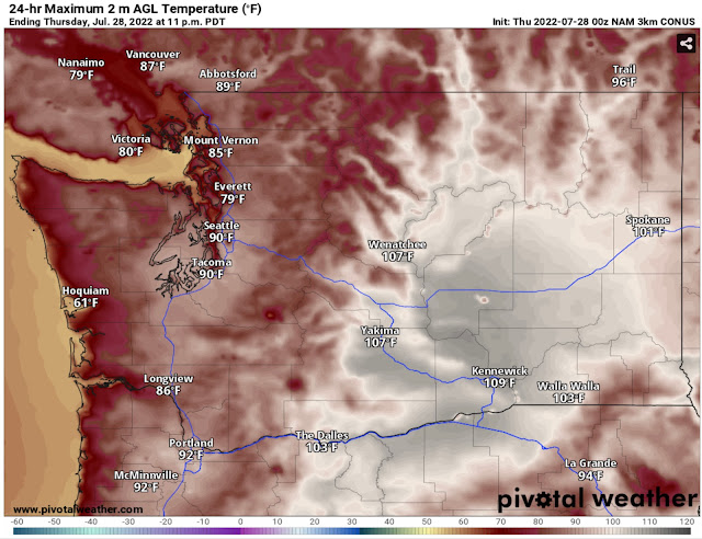
Thursday itself will be another hot day, as seen below.
Remember that over the past couple days, this forecast has been up to 3-5 degrees too cool for the lowlands. Factoring that in, expect lowland highs in the low to mid 90s (same in the Portland area). Eastern Washington will be very hot, in the low 100s to near 110.
Again on Thursday, the heat index will bring even hotter “feels-like” temperatures, as seen below.
This forecast has also been too cool. Expect heat indices (feels-like) to be in the low to mid 90s in the lowlands away from the water, and up to the low 100s closer to the foothills. Eastern Washington will feel like the 100s.
After 2 days above 90 degrees, each day makes non-air conditioned houses even hotter, increasing heat-related hazards for Pacific Northwest residents. This graphic from NWS Spokane shows the differences between heat exhaustion and heat stroke.
Additionally, smoke aloft will continue moving through the area’s skies on Thursday. The HRRR smoke forecast below shows moderate smoke coverage aloft at 2 PM Thursday.
This smoke will bring hazy skies and will only bring reductions in air quality at higher elevations. However, the combination of the heat wave and smoke aloft will bring ozone levels in the “moderate” to “unhealthy for sensitive groups” categories for the Cascade Foothills…so be aware of the outside air quality if you live in those areas.
You can view air quality (AQI) data by clicking “Federal Way Air Quality” on the right side of the blog. You can also type in any city from that link.
Stay dry and stay tuned…it appears that the hottest days of this heat wave will be Friday and Saturday. Also, remember to call 2-1-1 in Washington to find local cooling centers.


No comments:
Post a Comment