FastCast—Saturday, July 9 to Saturday, July 16:
Continued average summer weather is expected for Western Washington over the next week. Expect partly to mostly cloudy conditions on Saturday and Sunday, with highs in the mid 70s. Warmer weather arrives on Monday and Tuesday, with highs in the low 80s for most of the area and up to the mid 80s near the Cascades. Eastern Washington will reach the low 90s to low 100s, the Willamette Valley and SW WA will be in the low to mid 90s, and the coast will be in the upper 60s. Cooler and cloudier weather returns on Wednesday, with highs dropping to the low to mid 70s. Another stretch of warmer weather, with highs in the upper 70s to near 80, is expected for next Thursday to Saturday. Expect lows for the entire next week to be in the mid to upper 50s, with some areas dropping into the low 50s.
—————————————————————
Continue reading the full blog below!
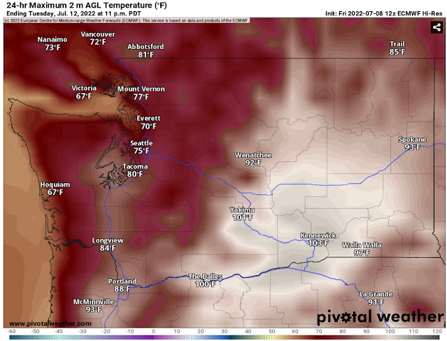
The next week in Western Washington will be mostly pleasant, with a couple of hotter than average days on Monday and Tuesday. This is seen in the European model forecast for Tuesday, expected to be the hottest day for the entire region.
This forecast is a tad cool for the Lowlands. Expect Tuesday’s highs in the lowlands to be in the low 80s (mid 80s for Tacoma southward). Eastern Washington will be sweltering, in the mid 90s to low 100s, with some places reaching the mid 100s. SW WA and the Willamette Valley will reach the mid 80s to low 90s. The coast will be much cooler, with highs only reaching the upper 60s at the ocean beaches.
Before the brief heat wave, we have some more pleasant weather ahead. Take a look at the HRRR forecast for Saturday. A pleasant, average summer day is expected. (Note that high temperatures for some cities may be cooler due to their proximity to the water).
Western Washington is generally in the low to mid 70s, while Eastern Washington reaches the mid 80s to low 90s. The coast and mountains are quite cool, in the upper 50s to low 60s.
Over the next 6-10 days, temperatures will be just above average for Washington, as seen in the NWS Climate Prediction Center outlook (from Pivotal Weather) below.
This generally means that there won’t be a significant heat wave, and that temperatures may be a tad above normal for July 14-18. Overall, a normal pattern for summer in Western Washington.
————————————————————
I will be taking a break from blogging for the next couple weeks, unless extreme weather is forecast. Updated forecasts and weather information can be found at the links below:
Pacific Northwest Weather Watch (Michael Snyder) on YouTube (Daily PNW weather briefings)
NWS Seattle (Forecasts available by clicking map or using box in upper left)
Weather Underground (Type city into top right, click “10-Day Forecast” tab)


No comments:
Post a Comment