FastCast—Wednesday, July 27 to Thursday, July 28:
The first day of the heat wave in the Pacific Northwest brought very warm temperatures to Western Washington. Highs in the lowlands reached the mid to upper 90s, except cooler near the water. The coast reached the upper 60s to upper 70s. Eastern Washington was scorching, in the mid 90s to mid 100s. Wednesday morning lows will not provide much relief, only dropping into the mid to upper 60s in Western Washington (except the coast), and barely cooling in Eastern Washington…to the mid to upper 70s. Wednesday will be another hot day, with highs in the low to mid 90s in Western Washington, except in the upper 90s to mid 100s again in Eastern Washington. The coast will be much cooler, with marine air bringing highs in the 60s. High dewpoints and relative humidity will again bring heat index (feels like) values in the mid to upper 90s and potentially the low 100s for Western Washington and the low to mid 100s for Eastern Washington. A similar story is expected on Thursday temperature-wise. Starting midday Wednesday, smoke aloft from Central California wildfires will fill Western Washington skies. Smoke will continue and increase through Thursday. This smoke will not impact air quality in Western Washington, except in the Cascade foothills, where decreased air quality is expected. The smoke will also bring a tint to the sun and could potentially drop a couple degrees off the forecast temperatures.
———————————————————
Continue reading the full blog below!
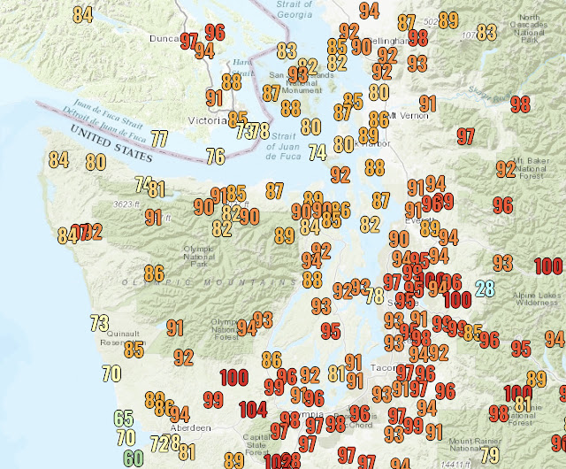
The first day of this long-duration Pacific Northwest heat wave is in the books (see high temperatures at the end of the blog). Temperatures felt even hotter (upper 90s to low 100s) in Western Washington due to the combination of hot temperatures and higher than normal dewpoints and humidity (called the heat index). This same phenomenon is ahead for Wednesday and Thursday.
Overnight lows will only reach the mid to upper 60s in Western Washington and the low 70s to near 80 in Eastern Washington.
Wednesday’s high temperatures are seen below from the high-resolution NAM model. Be aware that this model was a few degrees below the actual recorded temperatures on Tuesday.
Assuming that this forecast is a couple degrees too cool for Western Washington, expect Wednesday’s highs to be in the low to mid 90s in the lowlands (low to mid 80s near the water), in the low 60s to low 70s on the coast, and in the upper 90s to upper 100s in Eastern Washington.
Just like Tuesday, Wednesday’s temperatures will feel hotter due to high heat index values caused by higher humidity and dewpoints. This is seen below.
Heat index values will likely be in the mid to upper 90s for the Puget Sound area and well into the 100s for Eastern Washington.
After the 2nd straight 90+ degree day, nighttime relief Wednesday night to Thursday morning will be hard to come by, as seen below.
Overnight lows will reach the 60s in Western Washington, not providing much relief. It will be even worse in Eastern Washington, where lows will only reach the mid 70s ot low 80s.
The same story will be repeated on Thursday, but we will cover that in tomorrow’s blog. Now to the other weather story ahead for the region…smoke aloft from Central California wildfires.
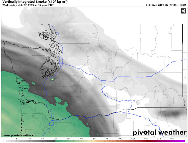
The HRRR vertically integrated smoke forecast below shows the beginning of the situation on Wednesday afternoon. Vertically integrated smoke is another description for smoke aloft, that does not impact surface air quality, except in the Cascade foothills through at least Friday, where ozone levels will be elevated.
At noon Wednesday, light smoke will begin entering the skies of Western Washington. The skies will gradually get smokier overnight and through Thursday morning, as seen below.
By Thursday afternoon, higher smoke concentrations will be aloft over Western Washington. Smoke may take a couple degrees off high temperatures when it is present. Despite this, temperatures will still peak in the low to mid 90s, with heat indices in the mid to upper 90s. There will also be a reddish tint to the sun, and likely significant haze on the horizon.
Continue following the blog for daily heat wave and smoke updates. Stay tuned and stay cool! Call 2-1-1 for cooling shelter information in Washington State.
Tuesday’s High Temperatures:


No comments:
Post a Comment