FastCast—Thursday, July 7 to Thursday, July 14:
After a showery and cool start to July, warmer and drier weather is ahead. Expect partly cloudy conditions from Thursday to Sunday, with highs in the mid to upper 70s. Temperatures warm and clouds decrease on Monday, as the Pacific Northwest feels some slight impacts from a heat wave over the interior of the US. Expect mostly sunny conditions from next Monday to next Thursday, with highs in the upper 70s to mid 80s. Currently, the warmest days are expected to be Monday and Tuesday. Expect lows over the entire next week to be in the mid to upper 50s.
———————————————————
Continue reading the full blog below!
A return to drier and warmer conditions will slowly occur over the next few days for Western Washington. Below is the NAM forecast for highs on Thursday.
Expect highs in the mid 70s around the lowlands, with some areas of cooler temperatures around Everett and Mount Vernon. Eastern Washington will be much warmer, in the low 80s in the north and mid to upper 80s in the south. The coast will be the coolest spot, likely in the low to mid 60s.
This is a contrast from recent showery and cooler weather that has been prevalent most of the first few days of July. Total July precipitation for the lowlands (7/1-6) is below.
Generally, the lowlands have received 0.05-0.6 inches, most in the foothills. Some areas of the mountains have received up to 1.4 inches of rain, due to showers that are more likely to form over the mountains. This continues the recent trend of above average rainfall. Note that average July rainfall for the lowlands is around 0.6 inches, so some locations are already doing quite well.
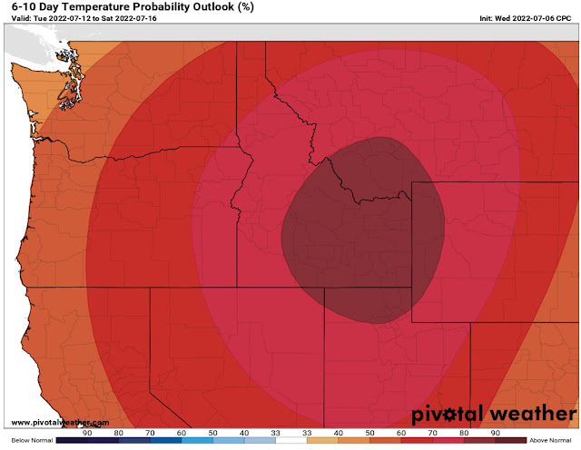
Now for a look ahead. We will take a look at the NWS Climate Prediction Center (CPC) 6-10 day outlooks (valid July 10-16) through Pivotal Weather.
At last, there is at least a 50% likelihood of above average temperatures for most of Washington State. This coincides with the upper 70s/low-mid 80s that are in the forecast for next week.
Accordingly, less precipitation is also expected, as seen below.
The CPC precipitation outlook shows a 30-40% chance of below average precipitation, something that we have not seen for a long time in Western Washington.
Enjoy the pleasant summer weather!


No comments:
Post a Comment