Tuesday, June 28, 2022

Marine Layer in Action: Massive Cooldown After Heat Wave

 FastCast—Wednesday, June 29 to Monday, July 4:

What a change! Tuesday’s high temperatures were a staggering 20-35 degrees below Monday’s…only reaching the mid 60s to low 70s (even with some rain showers), in comparison to the low to mid 90s on Monday. Wednesday will be cloudy, with highs again in the upper 60s to low 70s and a slight chance of showers. Thursday and Friday will be warmer, with partly to mostly sunny conditions and highs in the mid 70s to low 80s. Clouds increase again on Saturday, with highs in the mid 70s, and a slight chance of showers beginning in the afternoon. A system will move through on Sunday, with 0.1-0.2 inches of rain for the lowlands (isolated higher totals possible). More rain and higher totals (up to 0.75”) are possible in the mountains. Fourth of July currently looks to be cloudy with highs in the upper 60s and a chance of morning showers. Stay tuned!

———————————————————

Continue reading the full blog below!

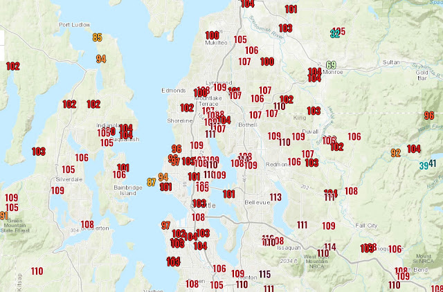
Tuesday was a major weather change from Monday, with high temperatures significantly cooler than 24 hours before, as seen in the NWS graphic below.


This is a huge 24-hour temperature difference for our region. Differences ranged from 20 to 35 degrees below Monday’s temperatures. 

Why was it so much colder on Tuesday? The answer is the marine layer, essentially a cloud deck that moves in from the ocean and typically brings cooler temperatures and onshore winds (which scour out heat and replace it with moist, cool air).

This can be illustrated through NOAA GOES Weather Satellite Imagery, comparing Sunday and Tuesday.


The image above for Sunday shows crystal clear skies over most of the Pacific Northwest, with the obvious marine layer moving up the Southern Oregon Coast. 
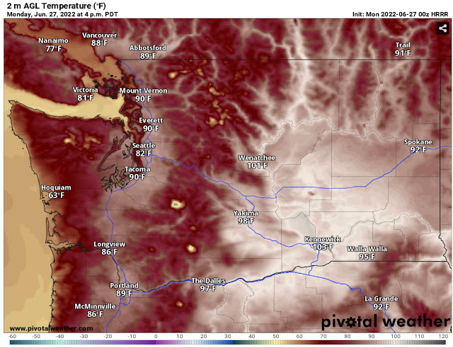
These mostly clear skies brought temperatures in the upper 80s to mid 90s on Sunday and Monday. 

However, the satellite image for Tuesday tells a whole different story.


Notice that Western Washington is shrouded in clouds. Complete cloud cover brought the significant decrease in temperatures and some definite heat relief. 

One of the unique aspects of our proximity to the Pacific Ocean is this “natural air conditioning” effect, commonly described as a marine push or marine air intrusion. This effect keeps areas west of the Cascades from having long-duration heat waves. 

It was certainly on full display on Tuesday! Quite an ironic day to have relief from a heat wave…considering the temperatures exactly one year ago…


Let’s be thankful that we only reached the mid 90s on Monday. (And to be clear: a repeat of June 2021 is quite unlikely for years, potentially decades, to come).

Sunday, June 26, 2022

Hottest Day on Monday, Then a Big Cooldown

FastCast—Monday, June 27 to Saturday, July 2:

Sunday was the first 90+ degree day of 2022 for Sea-Tac Airport and for much of the Pacific Northwest. Highs reached the upper 80s to low 90s around the lowlands, and the mid 90s near the foothills. Strong offshore flow on the coast brought abnormal highs in the upper 80s to low 90s, even at the ocean beaches. A warm night is expected overnight Sunday into Monday, with lows only dropping into the upper 50s to mid 60s. Monday will be hot, with lowland highs in the low to mid 90s. Marine air will be moving on the coast, keeping temperatures in the upper 60s to low 70s. Highs on Tuesday will be 20-25 degrees cooler than Monday, in the upper 60s to low 70s. There’s a chance of morning showers on Wednesday, with highs in the mid 60s. Highs rebound on Thursday and Friday, with sunnier conditions and highs in the upper 70s to low 80s. Expect similar conditions on Saturday, with increasing clouds and highs in the mid to upper 70s. From Monday night to Saturday night, expect lows in the 50s. 

——————————————————

Continue reading the full blog below!

Sunday was a hot day across the Pacific Northwest. Highs reached the upper 80s to low 90s in the lowlands, on the coast (due to offshore flow), and the mid to upper 90s in SW WA, the Willamette Valley, and Eastern Washington. 

Monday will be even hotter, as seen in the HRRR high-resolution forecast below.


There is good agreement among forecast models that Monday will be warm. The NAM high-resolution model below shows Monday’s highs as well.


Notice that the forecasts barely differ. Expect Monday’s highs in the lowlands to be in the upper 80s to low 90s, and up to the mid 90s in the foothills and mountain valleys. The coast will only reach the mid 60s to low 70s as marine air moves in. Eastern Washington will be sweltering, in the low 90s to mid 100s. 

Before the hot temperatures on Monday, we will have a warm night, as seen on the HRRR forecast below.


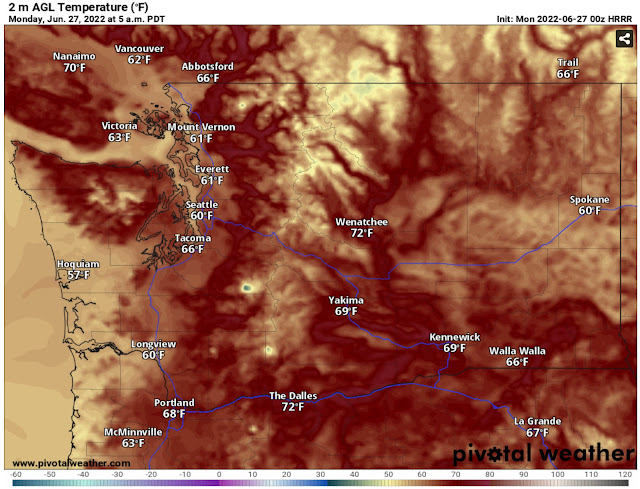
Expect a warm night everywhere (except the coast), with lows only dropping into the upper 50s to mid 60s. Eastern Washington and the Willamette Valley will have lows in the upper 60s to low 70s.

After the hot day on Monday, marine air and clouds will move into Western Washington. There will be a significant decrease in temperatures, as seen below in the HRRR forecast for temperature difference from Monday afternoon to Tuesday afternoon.


Temperatures in Western Washington will be 20-25 degrees cooler on Tuesday than on Monday. A similar trend, with temperatures 10-20 degrees below Monday’s highs, will prevail around the region.

So what will the temperatures be on Tuesday? The NAM forecast for Tuesday is below.


Tuesday’s highs will be in the low 70s in the lowlands and in the low to mid 80s in Eastern Washington. 

For those who dislike the heat…hang in there! There’s only one more hot day ahead!

Friday, June 24, 2022

Heat Wave Update: Hottest Temperatures of 2022 Begin Saturday

 FastCast—Saturday, June 25 to Friday, July 1:

The first heat wave of 2022 is upon us. Temperatures will increase on Saturday, with highs reaching the mid 80s in the lowlands. Near the water, temperatures will be in the low 80s, and near the foothills, highs will reach the upper 80s. The coast will reach the mid 70s to low 80s, coolest near the ocean. Eastern Washington will reach the upper 70s to low 90s. Temperatures further increase on Sunday and Monday, with Monday being the hottest day. Lowland highs will reach the upper 80s to low 90s, by far the hottest of the year so far. The coast will reach the upper 70s near the water to the upper 80s inland on Sunday, but decreasing to the upper 60s to mid 70s on Monday as marine air moves in. Eastern Washington will be sweltering, with highs in the upper 80s to mid 100s. An important note will be that lows in the lowlands during this heat wave will be in the upper 50s to low 60s, quite warm for nights in Western Washington. It is very important to note that water temperatures are still very cold, only in the upper 40s to near 60. Remember that shock and hypothermia can easily occur at these temperatures.

———————————————————

Continue reading the full blog below!

A heat wave is ahead for the Pacific Northwest. While it will not be even close to the June 2021 heat wave, the temperatures will still be hot for our area. 

The GFS forecast below for Saturday shows what high temperatures to expect.

Expect highs in the mid to upper 80s south of Seattle and in the upper 70s to low 80s north of Seattle. The coast will reach the mid 70s by the water to upper 80s inland. Eastern Washington, SW WA, and the Willamette Valley will reach the upper 80s to low 90s.

Temperatures increase further on Sunday and Monday. This is because of the heat trough, a tongue of low pressure moving north from California. The heat trough enhances temperatures and offshore flow, increasing the temperatures area-wide.

The Sunday forecast from the GFS ensemble forecast is below.


The heat increases around the region. Expect lowland highs on Sunday in the upper 70s to mid 80s north of Seattle and upper 80s to near 90 south of Seattle. The coast will reach the upper 70s to upper 80s. Eastern Washington, SW WA, and the Willamette Valley will reach the upper 80s to mid 90s.

Monday will be the hottest day around the area, except on the coast, where temperatures will be decreasing as the marine push moves in. The European model forecast for Monday is below.


Expect lowland highs in the upper 80s to low 90s. The coast will reach the upper 60s to mid 70s. Eastern Washington will reach the upper 80s to mid 100s. SW Washington and the Willamette Valley will reach the low 90s.

Another aspect of this heat wave will be warm low temperatures, as seen below on the high-resolution NAM model for lows from Saturday night to Sunday morning.


Expect lows around the region in the upper 50s to mid 60s, with some locations only reaching the upper 60s at night. 

Ahead of this heat wave, Heat Advisories (orange) have been issued for most of the Pacific Northwest.


While warning about the heat, the advisories also warn about water safety. Remember that water temperatures are in the upper 40s to near 60. Serious consequences exist from not taking caution in the water during this weather. Stay safe!

Another update will be posted on Sunday night, ahead of the hottest day on Monday.

Wednesday, June 22, 2022

Heat Wave Ahead: 90+ Degrees Possible in Western Washington

FastCast—Thursday, June 23 to Monday, June 27:

A heat wave is in the cards to begin summer in the Pacific Northwest. After a mostly cloudy day with afternoon sunbreaks on Wednesday, the warmup will begin on Thursday. Highs will reach the upper 60s to low 70s, with clouds clearing by midday. Expect lows Thursday night in the upper 40s to low 50s. Friday will be sunnier and warmer, with highs reaching the mid to upper 70s. The heat wave begins on Saturday. Highs will reach the low to mid 80s across the Lowlands and the upper 60s to mid 70s on the coast. Eastern Washington will be in the upper 80s to mid 90s, except cooler in the NE section. Sunday and Monday will be the hottest days. Temperatures in the lowlands will soar into the upper 80s to low 90s. The coast will reach the mid 70s to low 80s on Sunday (cooling to the upper 60s to low 70s on Monday) and Eastern Washington will be quite hot, with highs in the low 90s to low 100s. Nighttime lows in Western Washington will be on the warm side, in the upper 50s to low 60s. It is very important to remember that water temperatures are frigid…in the upper 40s to upper 50s in Puget Sound, the Salish Sea, and the Pacific Ocean. It is only slightly warmer, in the upper 50s to low 60s, in area lakes. Rivers are also running higher and faster than later in summer due to snowmelt. Be safe in and around water at all times during this heat wave.

————————————————————

Continue reading the full blog below!

A heat wave is ahead to begin summer in the Pacific Northwest. After a cool and wet spring, this will be quite an abrupt transition. 

Expect the hottest temperatures to occur on Saturday, Sunday, and Monday. The heat wave begins on Saturday, with the forecast from the GFS (American) model’s ensemble mean (average of many model runs) below.


Expect highs in the lowlands to be in the low 80s near the water and in the mid to upper 80s away from the water, especially in the foothills. The coast will reach the mid 70s to low 80s, and Eastern Washington, the Willamette Valley, and SW WA will reach the upper 80s (except in the northern tier of E. WA).

Temperatures continue to warm on Sunday, as seen in the GFS ensemble mean below.


This forecast may be a tad on the warm side, but it is reasonable to expect lowland highs in the upper 80s to low 90s. The coast reaches the upper 70s to low 80s (up to the mid-upper 80s a few miles inland), and the Willamette Valley, SW WA, and Eastern WA reach the mid 80s to mid 90s.

The heat will then peak on Monday. The GFS forecast is below.


Expect lowland highs to reach the low 90s (cooler near the water). Marine air will be moving onto the coast, limiting highs there to the upper 60s to upper 70s. Eastern Washington will reach the low 90s to low 100s, and the Willamette Valley & SW WA will reach the low to mid 90s. 

Temperatures will be hottest on Sunday and Monday due to the heat trough (low pressure created by hot temperatures) that will move north into the Pacific Northwest. It is seen below (outlined in blue) on the UW model for Sunday afternoon.


The black lines are lines of constant sea level pressure. Basically, this map is showing that the heat trough, which produces the Pacific Northwest’s hot weather, will be present during this heat wave, bringing conditions such as downslope winds, low pressure, and dominant offshore flow…all which bring hot temperatures to the region.

As always with heat waves, there will be risks. Take extra precautions if you are recreating near the water. Water temperatures are in the upper 40s to upper 50s in major waterways & rivers, and only a bit warmer, in the upper 50s to low 60s, in area lakes. Additionally, rivers are running higher and faster than normal due to snowmelt. It is very important to be aware around the water during the hot temperatures.

The NWS HeatRisk for Sunday is below.


Expect a Moderate (2/5) risk around the region. This means that anyone with sensitivity to heat or who will be unable to access cooling/hydration need to be careful. Similar conditions are expected on Monday.

Another heat wave update will be posted on Friday, when high-resolution models have forecasts for Saturday and Sunday. Stay tuned to local meteorologists (on Twitter, YouTube, and local news) and NWS Seattle for more information and updates.

Monday, June 20, 2022

Summer to Start With a Bang: First Heat Wave of 2022 Ahead

FastCast—Tuesday, June 21 to Monday, June 27:

After a chilly and wet spring, summer will begin with the Pacific Northwest’s first heat wave of 2022! This heat will not be anywhere close to the all-time record heat experienced in late June 2021. Temperatures warm into the low to mid 70s around the lowlands on Tuesday, with skies becoming partly to mostly sunny by late morning.  Clouds and marine air will move back in on Wednesday, with a slight chance of showers and highs cooling into the mid 60s. Highs rebound to the upper 60s to low 70s on Thursday, with mostly sunny conditions returning as well. Even sunnier conditions prevail on Friday and through the weekend. Friday’s highs will reach the mid to upper 70s. Then, the real heat builds. The warmest temperatures of 2022 (by far) will occur on Saturday, Sunday, and Monday, with highs reaching the mid to upper 80s in the lowlands and the upper 70s to mid 80s on the coast. Eastern Washington will bake in the heat, with highs reaching the upper 80s to low 100s. In Western Washington, there will be quite a range of nighttime lows in the coming days. Lows on Wednesday and Thursday mornings will be in the upper 40s, but from Saturday to Monday, expect lows in the upper 50s to low 60s, the warmest of the year so far. Continue reading below for the full forecast and cause of the arrival of summer weather!

———————————————————

Continue reading the full blog below!

After what has seemed like an endless pattern of chilly and wet weather, with few warm & nice days in between, warm summer weather is finally ahead for the Pacific Northwest!

In fact, this summer will get off to a warm start, with a heat wave in the cards from Saturday to Monday. The European model’s Monday forecast (June 27th) is below.


Temperatures will soar into the mid to upper 80s across the lowlands on Monday, with similar temperatures on Saturday and Sunday. 

However, before we get to the heat wave, we have some more routine weather to get to.

A warm day is in store for Tuesday, with highs reaching the low to mid 70s around the lowlands and mid to upper 80s in Eastern Washington. The NAM high-resolution forecast is below.


Expect highs reaching the low to mid 70s in the lowlands (a tad warmer than this forecast indicates).

Marine air will move in on Wednesday, with a slight chance of showers and mostly cloudy conditions. Highs will drop to the mid to upper 60s. The UW forecast for upper air patterns on Wednesday is below.


Notice a trough of low pressure passing just to the north of Washington State. This general pattern is key to clouds and showers, as we have experienced most of this spring. Additionally, the high pressure ridge is sitting offshore, negating any of its possible effects on the Pacific Northwest.

However, a major pattern change is in the cards for the weekend. The UW forecast for Monday’s upper air patterns is below.


This is a significant change. Notice that the high pressure ridge has built in over the Southwest US, with ridging extending northward to the Pacific Northwest. The position of this ridge (just east of the Sierra Nevada and Cascades) will provide the optimal conditions for the creation of a heat trough…which is low pressure created by high temperatures. Heat troughs are what cause many of Western Washington’s hot days.

By Saturday, a heat trough will be extending north from California into the Pacific Northwest, gradually moving north through Monday.

The NWS forecast for Saturday’s high temperatures is generally on the cooler side of projections, as seen below.


This forecast shows temperatures reaching the upper 70s near the water and the low 80s inland. 

On the warm side of predictions is the American GFS model. The GFS forecast for Saturday is seen below.


Although high temperature forecasts for the weekend and next Monday have been steadily trending upward, this forecast is likely on the high end. It brings highs in the mid to upper 80s for most areas south of Seattle, and highs in the upper 70s to low 80s north of Seattle (that is reasonable).

Bottom line: A heat wave is coming to the Pacific Northwest to begin summer, after a cool and wet spring. Forecasts for the heat wave will become more refined in the coming days, so stay tuned for an update on Wednesday evening!

Friday, June 17, 2022

Below Average Temperatures Continue, Drought Decreases in WA

FastCast—Saturday, June 18 to Tuesday, June 21:

After a dark and showery day on Friday, a gradual warmup will begin. By next Tuesday, temperatures will be warmer. Expect another chilly day on Saturday, with highs in the low 60s. Sunday will be a tad bit warmer, with highs in the low to mid 60s. Monday will be even warmer, with partly sunny conditions and highs in the upper 60s. By Tuesday, expect highs in the low to mid 70s, although conditions will be mostly cloudy. There is also a very slight chance of showers. Lows throughout the entire period will e in the low to mid 50s. Stay tuned for more information about the potential for warmer weather at the end of next week!

—————————————————————

Continue reading the full blog below!

We are just over halfway through June, and we have yet to have a day above 80 degrees in 2022…quite a rarity in recent years. In fact, highs on Sunday will be quite below average, as seen in the European model forecast below.


Temperatures will be 5-10 degrees below average over the Lowlands and up to 10-20 degrees below average over other parts of the West.

The Climate Prediction Center outlook (via Pivotal Weather) shows continuing below average temperatures for the end of next week.


This outlook shows the trend that has defined this spring in the Pacific Northwest. 

Despite the fact that this trend has brought many cooler days to the Pacific Northwest this spring, it does have one positive impact. The US Drought Monitor shows only moderate drought and abnormal dryness in Eastern Washington. This is a major improvement for Eastern Washington and is very good news!


The silver lining to this cold and wet spring is that our water supplies and snowpack are plentiful, drought coverage is decreasing, and the start of wildfire season will likely be delayed.

Tuesday, June 14, 2022

What Caused the Record Flooding on the Yellowstone River?

 FastCast—Wednesday, June 15 to Sunday, June 19:

A calm stretch of weather is ahead for Western Washington. On Wednesday, expect mostly cloudy conditions, with highs in the mid to upper 60s. Thursday will be partly sunny, with highs in the upper 60s. Friday will be overcast, with highs in the mid 60s and rain arriving by evening. Generally, expect 0.5 to 0.9 inches in the lowlands through Sunday, with most of the rain from late Friday through Saturday. More rain will fall south of Tacoma, on the coast, and in the mountains, where 1-2 inches are possible. There will be some showers on Sunday. Highs on Saturday and Sunday will be cooler, only reaching the low 60s. Expect lows throughout the entire period to be in the low 50s.

————————————————————

Continue reading the full blog below!

One of the biggest weather stories recently has been the complete closure of Yellowstone National Park due to record-breaking flooding on the Yellowstone River in NW Wyoming and Southern Montana. 

The photo below from a Yellowstone National Park Service helicopter via KBZK News (Bozeman, MT) shows the remnants of US Highway 89 (NE Entrance Road) along the Gardiner River, just north of Yellowstone National Park. The Gardiner River set an all time record at this location, which is about 20 miles south of where it flows into the Yellowstone River.


On this road alone, there are many scenes like this, where sections of highway are completely gone due to unprecedented flooding.

So…the big question is why did this flooding happen, and why on this scale? This blog will examine that.

The first factor is that there was significant rainfall over NW Wyoming and SW Montana, where the rivers in the Yellowstone River Basin originate. The map below shows rainfall in the region over the past week.

NW Wyoming and SW Montana received 3-5 inches of rain, a significant amount for that region. However, 3-5 inches of rain is usually not even close to enough to cause the massive flooding that occurred in Wyoming and Montana.

Enter in the snowpack situation…The snowpack in the mountains around the Yellowstone River’s source was significantly above average, a major contributor in the flooding. The graphic below from the USDA shows the percent of average snowpack in Wyoming.

Notice how much above average the snowpack is in NW Wyoming(100-800% of normal). Couple this with high temperatures as the flooding was occurring (NWS map below), and you can get a good picture of what caused this record-breaking flooding.


High temperatures in the headwaters region of the Yellowstone River were in the mid 40s to low 50s, much higher than necessary for significant snowmelt to occur. 

Unprecedented flooding was possible along the Yellowstone River and its tributaries because of the combination of heavy mountain rain, significant mountain snowmelt, and warm temperatures. 

So…what happened downriver?

Multiple all-time records were established on Monday, and some are still occurring…as seen in the hydrographs (river flood graphics) below.


The Yellowstone River shattered all-time records by 1-3 feet near Yellowstone National Park and near Livingston, MT. 

As this blog was being written on Tuesday night, the flood was moving downriver, and an all-time record is being set in Billings, Montana’s largest city.


The river will crest very near major flood stage. The Montana National Guard landed in Billings this evening to assist citizens as the flooding continues.

Some of the images of the flooding, from Yellowstone National Park all the way downriver into Southern Montana, are quite dramatic and devastating, as homes are washed away, water rescues occur, and towns are flooded. The images below from The Weather Channel show some of the impacts of the flooding on the Yellowstone River.


The flooding has receded in Yellowstone National Park and SW Montana, and the flooding is moving down the Yellowstone River toward Billings and other cities in Eastern Montana. However, the impacts of washed out roads and major water damage in Yellowstone National Park will likely bring closures for some time.


Saturday, June 11, 2022

Below Average Temperatures Continue & Atmospheric River Recap

FastCast—Sunday, June 12 to Thursday, June 16:

After a major June atmospheric river on Thursday and Friday and a beautiful day on Saturday, a return to much below average temperatures is in store for Sunday and Monday. Temperatures will only reach the upper 50s to low 60s, with lows in the upper 40s. There is a chance of showers on Sunday and Monday, including multiple Convergence Zone bands. Expect around 0.1-0.15 inches of rain in showers, except up to 0.5” under the Convergence Zone (likely around Everett). Temperatures will begin warming up on Tuesday, with highs reaching the low to mid 60s. Wednesday and Thursday will be even warmer (but still below average), with highs reaching the mid to upper 60s. Lows will be in the upper 40s to low 50s. Tuesday through Thursday will be partly to mostly cloudy, with no rain.

———————————————————

Continue reading the full blog below!

Our trend this spring has been below average temperatures, and that will likely continue. The graphic below shows the probability of above or below average temperatures, from the NWS Climate Prediction Center through Pivotal Weather.


The bullseye for below average temperatures is the Western US, especially the Pacific Northwest. 

So how chilly will it be? Take a look at Sunday’s highs from the NAM model.


High temperatures in the lowlands will only reach the mid 50s to low 60s. With average highs around 70 degrees for the lowlands at this time of year, that means that highs on Sunday and Monday will be 10-15 degrees below average.

This trend will spread around the entire Pacific Northwest, with high temperatures significantly below average, especially in the Inland Northwest. The European model forecast is below for temperature anomalies on Monday.


Temperatures will be significantly below average. The Lowlands will be 5-10 degrees below average, and areas east of the Cascades and in the Western Foothills of the Rockies will be a whopping 20 to 40 degrees below average. For example, Boise’s high on Monday will be in the upper 50s to low 60s, while average highs are typically in the upper 70s to low 80s. 

—————————————————

Atmospheric River Recap:

What an event! This atmospheric river was more on-par with an AR expected in fall or winter. The NWS precipitation analysis below shows the total precipitation recorded for the event.


The lowlands from Seattle southward received 1-2 inches of rain, with similar amounts around Portland and on the coast. The mountains of WA & OR received up to 6 inches! Many areas west of the Cascades received their entire month’s worth of rainfall in less than 3 days!

As expected, this rain brought rises on area rivers, with some getting close to flood stage. I took this photo at Snoqualmie Falls on Friday morning.


The flow at the Falls was similar to fall and winter flood events, but in June.
This image sums up our wetter and cooler than normal spring.

Wednesday, June 8, 2022

Atmospheric River Update: 1-2” In Lowlands, Rising Rivers Expected

FastCast—Thursday, June 9 to Monday, June 13:

The atmospheric river will begin impacting the Pacific Northwest on Thursday. The lowlands will receive most rain on Thursday and Friday, with additional showers possible on the weekend. Rain by early Sunday morning will total 1-2 inches around the lowlands. The foothills will pick up 1.5-3 inches, there will be 0.5-1 inches in the rain shadow (NE Olympic Peninsula to Everett area), and the coast and mountains will receive 2.5-5 inches. Many rivers draining into Western and Eastern Washington will rise, with many rivers draining into Western Washington reaching “action” stage (bankfull), and the Naches and Stehekin Rivers in Eastern WA will likely reach minor flood stage. Muggy weather is possible during this atmospheric river event, especially on Friday, when dewpoints in the upper 50s to low 60s are expected. On Thursday and Friday, expect highs in the low to mid 60s and lows in the mid to upper 50s (warm nights for early June). Partly cloudy conditions and a general break from the rain is expected on Saturday, with highs reaching the mid to upper 60s. Highs plummet on Sunday and Monday, only reaching the low 60s. Some locations may only top out in the upper 50s. Lows from Saturday night to Monday night will be in the upper 40s to low 50s.

——————————————————

Continue reading the full blog below!

A rare June atmospheric river is almost upon the Pacific Northwest. Substantial rain is expected around the region, along with rises on many area rivers. Before diving into high-resolution forecasts, let’s take a look at expected totals through Sunday morning from the European model.


The general synopsis is that the lowlands will receive 1-2 inches of rain, with even more in the foothills (1.5-2.5”) and the most on the coast and in the mountains (3-5”). 

For a broader view of the atmospheric river, take a look at the UW forecast for 5 PM Thursday, showing the massive plume of moisture arriving in the Pacific Northwest.


The blue/dark blue shades denote a strong atmospheric river, with subtropical moisture streaming across the Pacific Ocean. This setup is rarely found in June, and is very similar to fall and winter atmospheric rivers.

Let’s take a look at two high-resolution forecasts. First, the NAM model for precipitation through 5 AM Saturday.


The NAM shows that rain in the lowlands will decrease from south to north, with the least in the rain-shadowed areas near Port Townsend. Totals outside the rain shadow are 1-1.5 inches. The NAM shows 2-3 inches on the coast and isolated areas in the mountains with 5-10 inches! (You can see why rivers will be rising)

Next, the UW-WRF high-resolution forecast through Saturday evening (a few hours later than the NAM).


The UW forecast is the most aggressive with this atmospheric river, (basically the NAM forecast with higher amounts), giving the lowlands (south of Everett) 1.5 to 2.5 inches, with the highest amounts in the foothills. This forecast also gives the coast 2.5-3 inches and the mountains 3-8 inches. 

The bottom line with all these forecasts is that 1-2 inches of rain is a very likely possibility in the lowlands. This means that over 75% of June’s average rain will fall within 3 days.

As expected with this much rain, rivers will rise. The map below from the NWS Advanced Hydrologic Prediction System shows what to expect on the rivers.


Each yellow dot is a river near action stage (bankfull…just below flood stage). The Naches and Stehekin Rivers in Eastern Washington will reach minor flood stage. Note that the Snoqualmie, Snohomish, Skagit, and Nooksack Rivers will all reach action stage as well.

This much rain is uncommon in June. Remember that ponding, standing water, and potential urban flooding is possible, along with rises on small streams and creeks. 

One final note with this atmospheric river…conditions will be muggy at times. This is shown by forecasted dewpoints on the European model on Friday evening.


Dewpoints in the upper 50s to low 60s are expected. These are quite high for Western Washington, and you’ll likely feel the mugginess. 

Stay tuned to Twitter and our local meteorologists for updates about this June atmospheric river!

Monday, June 6, 2022

June Atmospheric River Heading for the Pacific Northwest

FastCast—Tuesday, June 7 to Saturday, June 11:

A nice day is ahead on Tuesday as a transitory (temporary) high pressure ridge moves through. Expect lowland highs in the low to mid 70s, with partly to mostly cloudy conditions around the area. However, a big change is ahead. An atmospheric river will impact the Pacific Northwest from Thursday to Saturday. This will be like the atmospheric rivers we experienced this past winter, but dialed back. Still, rain totals could be quite substantial for this time of year. As of Monday night, models are showing a total of 1-2.5 inches for the lowlands! This is a very large total for June. Additionally, the mountains and coast will receive 2-5 inches of rain. This system (generally split between 2 rounds…on Thursday and then on Friday & Saturday) will drive some rivers around the region toward bankfull, but not to flood stage. This may change, so stay tuned. Conditions will be mild and muggy during the atmospheric river, with highs in the mid 60s, and lows in the mid to upper 50s. Stay tuned for more information as the forecast becomes more accurate in the coming days.

—————————————————————

Continue reading the full blog below!

A rare June atmospheric river is heading for the Pacific Northwest. This rain event will generally be split between a system on Thursday and then on Friday/Saturday. 

The UW forecast below shows integrated water vapor transport, or the amount of water vapor being moved through the atmosphere, on Thursday evening, as the atmospheric river approaches the region.


This setup is reminiscent of fall or winter. This specific atmospheric river will bring less rain than its fall or winter counterparts. However, it will still be substantial for June, likely with more rain than this past weekend’s system.

Let’s take a look at the forecasts. The European model is most aggressive with the total rain from this system, as seen below in the total precipitation forecast through Sunday.


The European model shows a whopping 2-2.5 inches for the lowlands, which is actually more than the entire month of June’s total average rainfall. In this forecast, the mountains and coast would receive 2-5 inches, and Eastern Washington would receive 0.2 to 1.5 inches of rain.

The European model forecast is on the high side, so let’s take a look at another forecast. The GFS (American) model’s forecast for rain through Sunday is below.


The GFS is a lower resolution than the European, hence the very gradual changes in precipitation amounts. The GFS gives the lowlands 0.75 to 1.5 inches, still quite a lot for a June rain event. The mountains and coast receive 1-4 inches, and Eastern Washington receives up to 1 inch. 

One interesting aspect of this upcoming atmospheric river is the potential for some rivers around the region to reach bankfull. The NWS Advanced Hydrologic Prediction Service forecast below shows expected flood stages on area rivers.


Every yellow dot on a river is “action stage”, or bankfull. This rise on rivers would be due to the combination of warmer weather and the atmospheric river. Stay tuned for more information about the potential for flooding.

So…as of Monday night, the bottom line is that there will be substantial rainfall from Thursday to Saturday. What is uncertain is the amount of rain, and that will become more defined as we move closer to the event.

On a nicer note…a nice day is ahead on Tuesday, with a brief high pressure ridge bringing highs in the low to mid 70s, as seen below in the high-resolution NAM model.


Enjoy the nice weather on Tuesday as the atmospheric river heads toward us…and stay tuned for my next update on Wednesday!

Brief Spring Atmospheric River Bringing a Wet Weekend

  FastCast--Saturday, May 4 to Thursday, May 9: A fast-moving atmospheric river will bring a wet weekend to the Pacific Northwest. With the ...