FastCast—Monday, June 27 to Saturday, July 2:
Sunday was the first 90+ degree day of 2022 for Sea-Tac Airport and for much of the Pacific Northwest. Highs reached the upper 80s to low 90s around the lowlands, and the mid 90s near the foothills. Strong offshore flow on the coast brought abnormal highs in the upper 80s to low 90s, even at the ocean beaches. A warm night is expected overnight Sunday into Monday, with lows only dropping into the upper 50s to mid 60s. Monday will be hot, with lowland highs in the low to mid 90s. Marine air will be moving on the coast, keeping temperatures in the upper 60s to low 70s. Highs on Tuesday will be 20-25 degrees cooler than Monday, in the upper 60s to low 70s. There’s a chance of morning showers on Wednesday, with highs in the mid 60s. Highs rebound on Thursday and Friday, with sunnier conditions and highs in the upper 70s to low 80s. Expect similar conditions on Saturday, with increasing clouds and highs in the mid to upper 70s. From Monday night to Saturday night, expect lows in the 50s.
——————————————————
Continue reading the full blog below!
Sunday was a hot day across the Pacific Northwest. Highs reached the upper 80s to low 90s in the lowlands, on the coast (due to offshore flow), and the mid to upper 90s in SW WA, the Willamette Valley, and Eastern Washington.
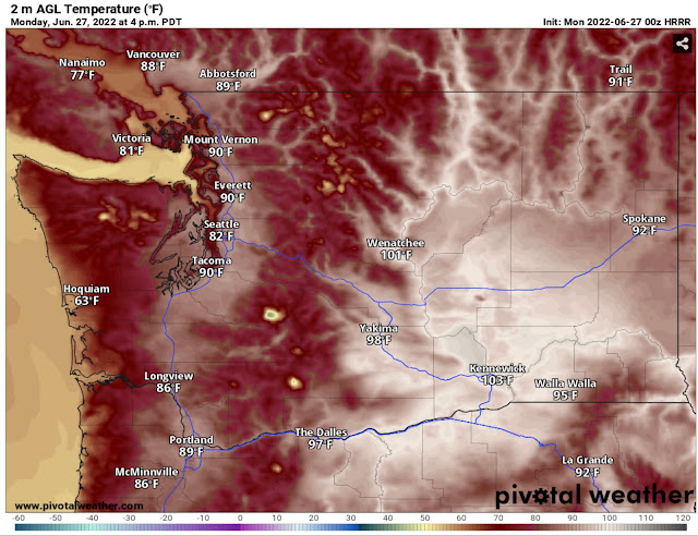
Monday will be even hotter, as seen in the HRRR high-resolution forecast below.
There is good agreement among forecast models that Monday will be warm. The NAM high-resolution model below shows Monday’s highs as well.
Notice that the forecasts barely differ. Expect Monday’s highs in the lowlands to be in the upper 80s to low 90s, and up to the mid 90s in the foothills and mountain valleys. The coast will only reach the mid 60s to low 70s as marine air moves in. Eastern Washington will be sweltering, in the low 90s to mid 100s.
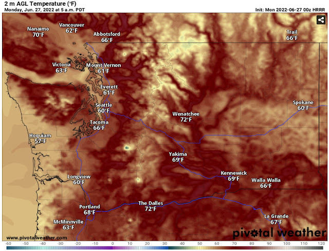
Before the hot temperatures on Monday, we will have a warm night, as seen on the HRRR forecast below.
Expect a warm night everywhere (except the coast), with lows only dropping into the upper 50s to mid 60s. Eastern Washington and the Willamette Valley will have lows in the upper 60s to low 70s.
After the hot day on Monday, marine air and clouds will move into Western Washington. There will be a significant decrease in temperatures, as seen below in the HRRR forecast for temperature difference from Monday afternoon to Tuesday afternoon.
Temperatures in Western Washington will be 20-25 degrees cooler on Tuesday than on Monday. A similar trend, with temperatures 10-20 degrees below Monday’s highs, will prevail around the region.
So what will the temperatures be on Tuesday? The NAM forecast for Tuesday is below.
Tuesday’s highs will be in the low 70s in the lowlands and in the low to mid 80s in Eastern Washington.
For those who dislike the heat…hang in there! There’s only one more hot day ahead!


No comments:
Post a Comment