Friday, January 31, 2020

Strong Winds & Rain Before Brief Cold Weather

This has been one crazy stretch of active weather, and it’s not stopping! Heavy rain and windy conditions are the two biggest hazards for these next 2 days. Let’s take a look at the details. 

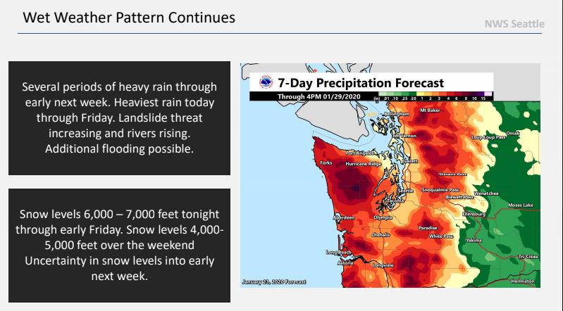
An atmospheric river is aimed straight at the area from now through Saturday. 

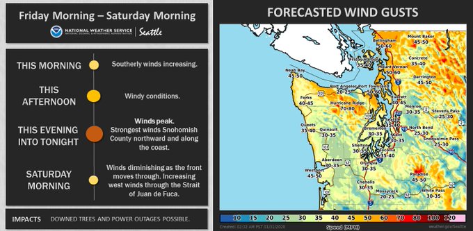
A new hazard is windy conditions. Winds will increase through the day Friday, peaking late Friday afternoon through Friday evening. Winds gradually diminish through the night. Peak winds will be sustained 30-40 mph with gusts to 50 mph. Due to the large amount of rain we've received recently, soils will be more saturated, increasing the power outage potential. This graphic from NWS Seattle shows expected winds. 

Image

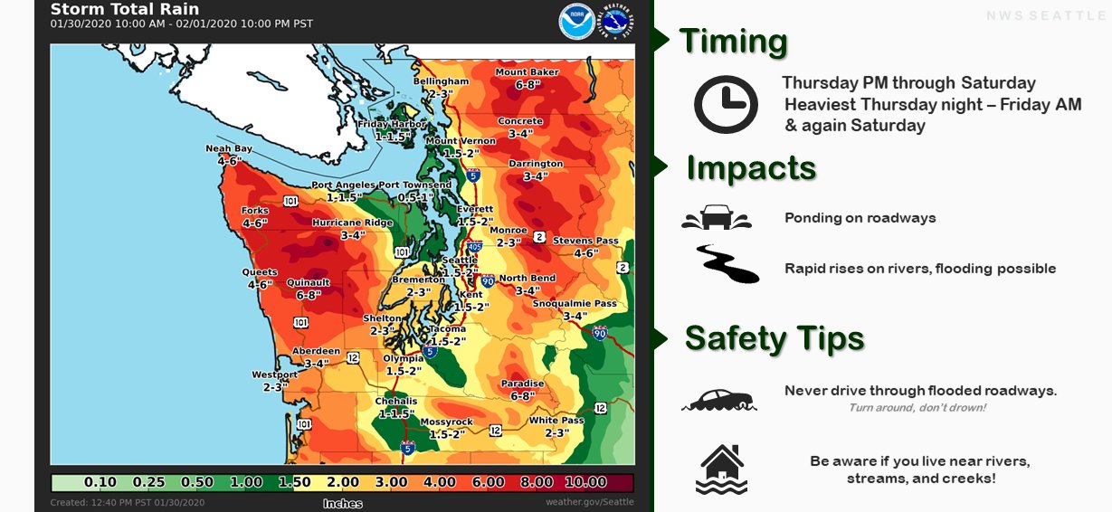
There's a chance that windy weather will continue through Saturday morning. Watch the forecasts! Here's a timeline of the weather through Sunday.

Image

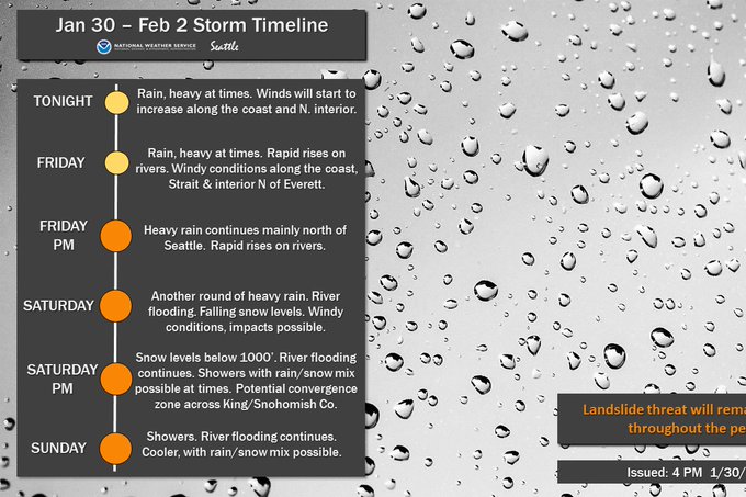
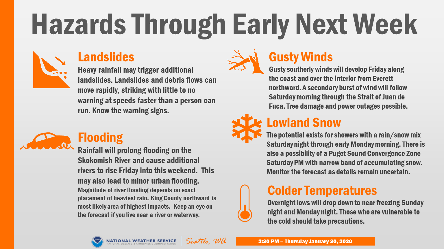
Expect 1-2 more inches of rain through Sunday. This will keep the landslide and flooding threats high. You'll notice that it says rain/snow mix possible on Saturday night and Sunday. There is a small chance of this happening, but it most likely won't happen. There are other small chances of snow through Tuesday...but stay tuned to the blog for the latest updates!!


Tuesday, January 28, 2020

Heavy Rain & Gusty Winds Likely, Cold To Follow

The rain just won't stop! In the last week, our area has received 0.5-1.2 inches of rain...and even more is coming, potentially the biggest storm(s) of the month. Let's take a look at what's going to happen and what impacts we'll see.

Here's an outlook from NWS Seattle showing our expected weather conditions through Sunday. (Yes it does say rain/snow mix possible...stay tuned :)

Image


Wednesday and Thursday will feature 0.3-0.6 inches of rain, with winds gusting 20-25 mph. This will be "routine" for us with what we've been seeing lately. (Speaking of which, the month has seen 5-8 inches of rain depending on where you live...that's crazy!!) 

This forecast from NWS Seattle shows expected rain from Thursday evening to Saturday evening. 

Image

As you can see, our area will get 1.5-2 inches of rain. The majority of this rain will occur Friday and Saturday.

A storm system moves in to the area late Thursday, and rain from that system continues through Friday evening. Winds from this system will gust 25-45 mph (stronger from 6 pm and on through the night). Rain will total 0.5-1 inch. 

The biggest, rainiest, and windiest system moves in early Saturday morning, after a break Friday night. This system will bring 0.7-2 inches of rain. Winds will gust 35-45 mph through the day, peaking from 12 midnight to 7 am. 

Here's an overview of hazards for the next few days. Be prepared for all these events!

Image

A Flood Watch has been issued for these storms. 1-3 inches of rain in the lowlands and 4-7 inches in the mountains before snow levels fall on Sunday. Rivers will undoubtedly rise...more on that below. As always, find forecasts and alerts at NWS Seattle.

Flooding is likely with these storms. Be very careful for ponding and standing water on roads, especially freeways. Rivers will rise, so use caution, as floodwaters will be fast-moving and hazardous. Here's the graph for the Puyallup River at Puyallup.

The Puyallup River will rise to 19-22 feet, less than 6 feet from flood stage. This will flood some roads very near the river. Use caution in the valley, especially around the river and levees. Check river & flooding conditions on the NWS Flooding Site.

After the rain and storms move through, it should clear up and cool down, with temperatures around or below freezing. Some weather forecasts show a chance of snow...stay tuned!!

Friday, January 24, 2020

Rainy Weather Continues, Additional 3-4 Inches Possible

It has been a rainy past few days in Western Washington! Our storm total since the 21st has been 1.38 inches! The month of January now has 5 inches of rain! 

At this point, it seems that we are locked in this rainy pattern through the end of January, with another 2-4 inches of rain possible. This map from the NWS shows expected rain through the end of the month. With 3-4 inches likely, the total will be 8-9 inches for January!

Image

Let's take a look at what to expect this upcoming week...

Saturday will start with an early morning system, with rain tapering to showers through the day. 

Rain will become steadier on Sunday, with around 0.4 inches possible. Some locally windy conditions are also possible beginning Sunday. (Graphics from NWS Seattle).

Image

Additional systems bringing around a half inch of rain per day are likely from Monday to Friday. Windy conditions are possible through Tuesday.

Image

Forecasts show 1-2 inches of rain likely through Wednesday. With all this rain expected, I wouldn't be surprised to see rivers stay higher than normal or in some cases in flood stage for the next week. You can check the current river conditions here at the NWS Hydrology & Flood Site.

You can see that the river has crested, around midnight Friday morning. Normal level is around 12 feet, but the graph shows that the river will stay between 15 and 17 feet for the foreseeable future. This is 3-5 feet higher than normal. No major impacts are expected at this time, but a drive over the river will reveal that it is significantly higher than usual.

In addition to this ongoing flooding threat, there is an increased threat of landslides in Western Washington, due to high soil moisture and instability.

Tuesday, January 21, 2020

Rainy Week Ahead

We have a rainy few days on tap. We have fully transitioned out of the cold pattern, so it will now feel much more like a "normal winter" in the Seattle area. Rain through Friday are likely to total 2-3 inches. Let's take a look at what to expect the next few days...

Here's a graphic from NWS Seattle showing the expected rain for the next few days.


Tuesday will be showery, with up to 0.4 inches of rain possible, and winds gusting 25-40 mph. Expect gusty winds and heavy rains in storm cells.

Wednesday is the start of a rainier few days. As stated in the graphic above, warmer weather systems and heavier rain is likely. Expect around 0.5 inches of rain on Wednesday.

Thursday looks to be the rainiest day of the week, with 0.8-1.1 inches likely. There is also a chance of gusty winds on Thursday as well. Snow levels in the mountains will begin to rise up to 5,000-6,000 feet. This will make rivers rise, and flooding is to be expected. Check river levels on the NWS Flooding database.

Friday will also be rainy, with around 0.5 inches of rain possible. Rain will gradually taper through the day Saturday, with more rain possible through the next week. Flooding will start to decrease, but some rivers could remain high due to their location.

Rain totals by the end of this week will be between 2 and 3 inches.

The interior lowlands will receive 1.2-2.5 inches of rain through Saturday morning. The coast, Olympics, and Cascades will be socked with 2-10 inches of rain. That will make for some crazy flooding!

Prepare for flooding and heavy rains. Rising snow levels will melt a large amount of snow in the mountains (Olympics & Cascades).

Friday, January 17, 2020

Snow Recap...What Happened?

Many of us wondered why it did not snow nearly as much as forecast this past week. Let's take a look at why...

On Sunday, an Arctic front was expected to move south down Puget Sound towards the Seattle area. This front moved very slowly, and before it could move south, a Convergence Zone developed between Everett and Mount Vernon, due to Southwesterly flow moving around the Olympic Mountains. This is the same SW flow that caused 35-45 mph wind gusts in our area. Back to the Convergence Zone...it sagged south to downtown Seattle and dumped up to 8 inches of snow between Mount Vernon and Seattle. 
Image result for snow convergence zone seattle 2020
As you can see in the picture above...there was a lot of snow in the north Seattle area! This snow band "stopped" moving south in the Kent area. Some scattered snow showers moved through the South Sound on Monday morning, producing around a half inch of snow. Some of this snow made it down to Puyallup on Monday morning (picture below), but it melted through the day. 
Monday night was the South Sound's best chance at snow, and most areas south of Seattle received 1-2 inches of snow. Snow lingered on the ground and some surfaces through the day Tuesday and through Wednesday night. On Wednesday night, the temperature rose up to 45 degrees. This temperature rise was associated with strong easterly winds out of the gaps in the Cascades. These winds gusted 25-45 mph in the South Hill, Puyallup, and Federal Way areas. Winds like this are extremely localized, due to the nature of gaps in the mountains. 

We rounded out this week with some very localized snow, and my house in Federal Way received a dusting of snow this morning.

Some roads were icy/snowy this morning because of below freezing temperatures overnight. 

This morning was the last morning with a chance of snow...we will go back in to a rainy and sometimes windy pattern for the next week.

Thursday, January 16, 2020

Final Chance of Snow Before Transition To Rainy Weather

There is one final chance of snow tonight...with a small chance of accumulations. This graphic from NWS Seattle shows the chance for snow tonight. Keep in mind that this will be hit-or-miss snow showers and that in order to receive accumulations, you will need to be impacted by a snow shower.
Notice that the areas within the red dashed line have the highest chance of accumulations tonight. The entire South Sound region is inside that line. Accumulations are expected to be below 1 inch. Temperatures tonight will hover between 30 and 35, and in a snow shower, temperatures will fall and snow could accumulate on surfaces, possibly pavement. Be prepared to see some brief snow tonight! As we move on from this cold pattern, we will transition back to rainy and sometimes windy weather.

Tomorrow, snow levels will rise through the day, giving way to rain here in the lowlands. Windy conditions are possible as well, with gusts 20-35 mph at times. Expected rainfall through the next 3 days is 0.4-0.5 inches. 

Brief Spring Atmospheric River Bringing a Wet Weekend

  FastCast--Saturday, May 4 to Thursday, May 9: A fast-moving atmospheric river will bring a wet weekend to the Pacific Northwest. With the ...