Sunday, January 30, 2022

Convergence Zone, Breezy Conditions in Wake of Cold Front

FastCast—Monday, Jan. 31 to Thursday, Feb. 3:

After over a week of stagnant air and foggy conditions, a frontal system on Sunday brought rain, wind, and mountain snow. Air quality is back safely in the “good” category. 0.15 to 0.8 inches of rain fell across the region, with mountain snow blanketing all the passes. During and behind the front, winds have increased as well. Gusts reached 30-45 mph in the lowlands and 45-55 mph along the Strait of Juan de Fuca. Convergence Zone banding will bring additional rain and mountain snow between Seattle and Arlington (approximately Snoqualmie to Stevens Passes). Up to 2 feet of snow will fall at the passes through Monday night. Breezy conditions, with gusts of 25-40 mph will continue at times through Monday afternoon. Dry conditions will prevail until Wednesday morning, when there is a chance of showers. These may be rain/snow mix showers as Wednesday morning temperatures will be in the upper 20s to low 30s. Drier conditions are expected on Thursday. Expect highs in the low to mid 40s, and lows in the upper 20s to mid 30s through Thursday.

——————————————————————

Continue reading the full blog below!

A frontal system moved through Western Washington on Sunday, bringing rain, wind, and mountain snow. 

The HRRR model below shows predicted snow through Monday evening. 


From Sunday evening to Monday evening, 1-2 feet of snow will fall. A Winter Storm Warning is in effect for the Cascades of King and Snohomish Counties for 8-24 inches of snow. Difficult mountain pass travel is possible through Monday evening. 

In addition, breezy winds will continue through Monday afternoon. Gusts of 25-40 mph are expected. The HRRR forecast at 3 AM Monday is below.


The strongest winds will be north and south of Seattle, especially along the Strait of Juan de Fuca. 

Special weather note: Very cold temperatures occurred in Florida this morning, with lows in the upper teens to low 30s! This is very rare!


Friday, January 28, 2022

Major Nor’easter Bringing Historic Snow & Blizzard Conditions to New England

As relatively tranquil weather prevails around the Pacific Northwest, an intense Nor’easter will bring very heavy snow and strong winds to New England from late Friday night through Saturday.

The snow accumulations will be incredible, as seen in the HRRR model forecast below. This is extraordinary considering that this snow will fall in under 24 hours!


Major snow totals are expected, with significant travel impacts expected. The highest amounts of 18-30 inches are expected on Long Island and in eastern Connecticut, Rhode Island, eastern Massachusetts, and eastern Maine. Additional totals of 12-18 inches are expected along the coast from Delaware to coastal Connecticut, including New York City.

Snow will fall at very heavy rates of up to 2-4 inches per hour. This, combined with strong winds, will produce very difficult to impossible travel conditions.

What’s causing all this? A rapidly-deepening low pressure center, or “bomb cyclone” (when a storm deepens by 24+ millibars in 24 hours) is moving up the eastern seaboard. These type of storms move northeast and contain strong northeast winds, hence the name “Nor’easter”.

The European model shows the storm at 4 AM EST Saturday, at 979 millibars, off the coast of Virginia and Delaware.


12 hours later, at 4 PM, the low pressure center is just off Cape Cod. In 12 hours, the storm deepens 14 millibars, from 979 to 965, quite a deep storm!


Notice the intense pressure gradient to the west of the storm. This will produce very strong wind gusts, and due to the ongoing heavy snow, blizzard conditions will occur. Blizzard Warnings are in effect for portions of the coast from Virginia to Maine for the first time since March 2018.

Below is the NAM model forecast for wind gusts at 11 AM Saturday.


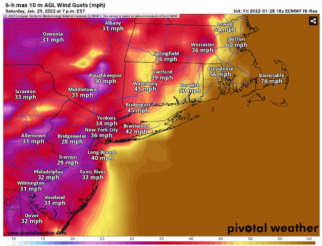
A widespread blowing snow/blizzard conditions event is expected. Let’s take a look at another forecast. The European model is below, showing even stronger winds.


Generally, expect peak gusts of 40-60 mph in areas from the Jersey Shore along the interior areas to Maine. Eastern Long Island, eastern Connecticut, Rhode Island, and the Boston area to have gusts of 50-65 mph. Cape Cod and coastal Massachusetts will have the highest gusts of 60-70 mph. Some areas on Cape Cod will have gusts up to 75-80 mph. 

To add to all this weather insanity…coastal flooding of 1-2 feet above mean water level is expected along the coast from approximately Delaware northward. This will exacerbate the overall weather situation, adding coastal flooding & storm surge to blizzard conditions.

Here is a graphic from NWS Boston summing up the situation for what will likely be the hardest-hit areas of eastern Connecticut, Rhode Island, and Massachusetts.


This will be a significant storm for New England. Stay updated on Twitter, The Weather Channel, and the National Weather Service

HurricaneTrack.com (run by Mark Sudduth) will be live-streaming on YouTube in coastal Massachusetts. Click below to access his channel:

Thursday, January 27, 2022

Inversion & Fog Continues Through Friday, Pattern Change on Sunday

FastCast—Friday, Jan. 28 to Monday, Jan. 31:

The fog and inversion (with very welcome afternoon sun) will continue on Friday. Saturday will be a transition day, with a bit less fog and instead some “normal” mostly cloudy conditions. On Sunday, the pattern will change, with rain in the lowlands and snow in the mountains. Expect 0.2 to 0.5 inches of rain and 6-12 inches of snow at the passes, most above 4,000 feet. Breezy winds up to 30 mph will bring mixing to the atmosphere and clear out the stagnant air. Through Monday, expect highs in the mid 40s to low 50s (colder if fog doesn’t clear on Friday or Saturday) with lows in the low to mid 30s. 

———————————————————

Continue reading the full blog below!

Most of the Puget Sound region had some afternoon sun today! Highs reached the mid to upper 40s, the warmest since last Friday! At sunset, a layer of haze could be seen on the horizon. This is a result of the persistent inversion and associated degraded air quality. The EPA AirNow map below shows AQI readings Thursday evening.  


Yellow readings are “moderate” and the spotty orange readings are “unhealthy for sensitive groups.” Moderate AQI is prevalent around the region, and sometimes the smell of wood smoke can be observed. 

There is good news…the pattern will change on Sunday. Friday and Saturday will be similar to Thursday, including chilly morning temperatures in the upper 20s to low 30s. 

A pattern change is ahead on Sunday. Below is the European model precipitation through Monday morning.


These totals are likely on the higher end…but generally, 0.2-0.75 inches are expected  in the Lowlands, with higher totals of 0.8 to 1 inch in Whatcom & Skagit Counties and 0.75 to 1.5 inches on the coast. 

Snow will return to the mountains as well. Below is the European model forecast for snow through Monday morning (more will likely fall after that, but not much).


Expect 6-12 inches at the passes, with more (up to 2 feet) at higher elevations. Some mountain pass delays may be possible, so be prepared if you’re crossing the mountains. This will be the first significant snow the passes have received since the major storm earlier this month.

Additionally, winds gusting up to 30-35 mph on Sunday will clear out the stagnant air.

Monday, January 24, 2022

Areas of Fog & A Strong Inversion Continue Through Midweek

FastCast—Tuesday, Jan. 25 to Friday, Jan. 28:

The foggy and stagnant pattern that has gripped the Lowlands is expected to continue for the next few days. Expect areas of fog and some dense fog in spots. Air quality will be moderate at times, especially in areas with lots of wood burning. Highs will be in the upper 30s to low 40s through Wednesday (warmer if fog lifts) and in the mid to upper 40s on Thursday and Friday as the fog becomes less likely. Expect lows in the low to mid 30s. A general pattern shift begins on Friday, with less fog and a chance of showers by late Saturday as the high pressure ridge breaks down.

———————————————————

Continue reading the full blog below!

The Pacific Northwest continues to be impacted by a persistent high pressure ridge offshore. It is seen below in the European model forecast for Monday evening.


This high pressure ridge has been causing an inversion (where temperature increases with height, instead of decreasing). The sounding below from near SeaTac Airport shows the sharp temperature increase (the blue box) in the first few thousand feet of the atmosphere. Provided by Pivotal Weather.


So what does this mean? Essentially, colder air (and sometimes fog & low clouds) is trapped in the lower atmosphere, but a few thousand feet above, temperatures are much warmer.

A great source to learn more about inversions is Cliff Mass’s 1/23 blog post.

Inversions make for some interesting effects on temperatures. Take a look at Monday’s high temperatures below.


The Puget Sound area reached the upper 30s to low 40s and Ellensburg and Wenatchee didn’t even get above freezing. But look at the mountains…temperatures reached the mid 40s to low 50s above the inversion, the opposite of a usual pattern. 

To see these effects in even more detail…look at this zoomed in view.


Stations near Easton on I-90 and on parts of SR-410 hit the upper 40s to mid 50s, but  Ellensburg didn’t get above 30 degrees! That’s a 20-degree temperature difference between Ellensburg and Easton!

This general pattern, with fog and low clouds at lower elevations and warmer temperatures and sun at higher elevations and on the coast will continue through Thursday, before fog clears up a bit.

Saturday, January 22, 2022

Dense Fog & Degraded Air Quality Through Thursday Due to a Persistent Ridge Offshore

FastCast—Sunday, Jan. 23 to Thursday, Jan. 27:

A persistent and massive high pressure ridge will keep the same weather pattern going over the next 5 days. Expect fog, with visibility potentially under 1/4 mile, each morning through Thursday. Fog will be dense in places, and potentially become freezing fog if temperatures dip below freezing. This can create roadway icing, especially on bridges/overpasses. In the afternoons, fog will clear in some places, bringing partly to mostly sunny conditions and highs in the mid 40s to low 50s. Where fog doesn’t clear, high temperatures are significantly lower, with highs only reaching the mid 30s to low 40s. Lows region-wide will be in the low to mid 30s. Little wind and no “mixing” of air in the lower atmosphere will cause stagnant air and degraded air quality by Monday for most of Western Washington. Expect degraded AQI through at least Wednesday. Additionally, due to downslope flow caused by the persistent high pressure ridge, temperatures on the WA/OR Coasts will be much warmer than the interior (as warm as 70+ on the south Oregon coast!). Keep reading below for more information!

—————————————————————

A persistent area of high pressure over Vancouver Island and the Pacific Ocean will bring a similar weather pattern to the region through Thursday. The main weather impact in the lowlands will be fog. 

Dense fog is possible at times (seen below in Federal Way on Saturday morning), with visibility under 1/4 mile in some spots. 


With nightly low temperatures near freezing in parts of the region, freezing fog may form. This can lead to quick roadway icing, especially on bridges and overpasses.

The cause of this calm yet interesting weather is a large high pressure ridge centered offshore and near Vancouver Island, seen in the European model forecast below for upper-atmosphere pressure anomalies on Saturday evening.


The high pressure is also visible on surface-level maps. The UW forecast for 11 AM Sunday shows the ridge offshore of Vancouver Island.


Persistent high pressure ridges like this one bring stable atmospheric conditions, with little “mixing” or movement of air in the lower atmosphere. This increases the likelihood of stagnant air. Due to this, NWS Seattle has issued an Air Stagnation Advisory from Sunday evening to midday Wednesday. The alert is posted below.


It is important to not burn outside and limit wood burning as much as possible. Find air quality forecasts at airnow.gov and check your local AQI agency:


A very interesting impact of this pressure ridge setup is the effect it has on coastal high temperatures, mainly from Long Beach, WA southward. Check out the UW forecast for temperatures at 12 PM Sunday below.


Wow! Red colors are 56°+, expected from Long Beach southward. Take a look at the southern Oregon coast…this area around Brookings is called the “banana belt of the Oregon coast” and frequently has very warm temperatures due to downslope winds. Brookings will reach the upper 60s to mid 70s on Sunday…summer temperatures in the middle of winter!

However…the reverse of this effect is also seen, as cold air is trapped in Eastern Washington and Idaho’s Snake River Plain, where temperatures will be below freezing. Pink and purple colors in Idaho are temperatures of 5-20 degrees.

Even calm weather can produce interesting effects in the Pacific Northwest!

Wednesday, January 19, 2022

Last System of January, Then A Long Stretch of Dry Weather

FastCast—Thursday, Jan. 20 to Thursday, Jan. 27:

A weather system will move through Western Washington late Wednesday and through Thursday. Expect 0.25-0.6 inches of rain by Thursday evening, most in potential Convergence Zone bands from midday to Thursday night. Additionally, 2-6 inches of snow will fall at Snoqualmie and Stevens passes, with more in higher elevations north of I-90. Convergence Zone bands may bring briefly heavier snow. Breezy conditions are possible on Thursday as well, mainly north and south of Seattle, with gusts of 25-40 mph possible. A large high pressure ridge will build off the coast starting on Friday. This will bring at least 5 days of dry weather with morning fog and afternoon sun. (Uncertainty does remain regarding how long fog will last each day). Highs will be in the mid 40s to low 50s and lows will be 30s. Lows near freezing are possible, so there is a potential threat of freezing fog. With relatively little wind and consistently dry conditions, air stagnation and degraded air quality may become an issue. Stay tuned! Also…this will likely be the longest dry stretch (by far) since September!

—————————————————————

Continue reading the full blog below!

The last weather system of January will move through late Wednesday into Thursday. The rain forecast (HRRR model) through Thursday night is below.


Generally, expect 0.25 to 0.5 inches of rain around the lowlands. A decent Olympic rain shadow is expected due east of the Olympics and to the Seattle/Everett area. North of Everett, 0.6-1 inch of rain is expected, and about the same on the coast.

Mountain snow is possible too. Expect 2-6 inches in the passes, with more at higher elevations between Snoqualmie and Stevens Passes. Briefly heavier snow is possible if Convergence Zone bands align with the passes. The HRRR snowfall forecast through Thursday night is below.


Breezy conditions are also possible north and south of Seattle on Thursday. Gusts of 25-40 mph are possible, strongest north of Everett and along the Strait of Juan de Fuca.

A large high pressure ridge will build off the coast starting Friday, seen below on the European model.


This ridge will bring consistent dry weather to Western Washington starting Friday. Expect morning fog each day, with some days potentially remaining foggy in the lowlands. High temperatures will be in the mid 40s to low 50s, with lows in the 30s. 

On the WA/OR coast, downslope flow will bring much warmer temperatures, with highs in the mid to upper 50s on the Washington coast, and potentially into the 60s on the Oregon Coast. The European model high temperature forecast for Sunday is below. Notice the warmer temperatures on the coast.


This consistent dry and calm weather with little wind will elevate the potential for air stagnation starting this weekend. Stay tuned!

Monday, January 17, 2022

Cloudy & Rainy Week, Then A Massive High Pressure Ridge Takes Over

 FastCast—Tuesday, Jan. 18 to Tuesday, Jan. 25:

After a few calm & foggy days, a return to showery and cloudy weather is expected. A weak system will bring showers to the region from Monday night to Tuesday morning. Only light rain is possible. A system with a stronger cold front and potential convergence zone will move through from Wednesday to Thursday, with 0.3-0.75 inches of rain in the lowlands and 2-8 inches of snow at the passes. Expect high temperatures to be in the mid to upper 40s, with lows in the low 40s. A significant pattern change arrives on Friday. A massive ridge of high pressure (see below for more details) will build up near Vancouver Island. This ridge will bring at least 5 days of partly-mostly sunny conditions with possible morning fog. Highs will be in the upper 40s to low 50s, with lows in the mid 30s. This ridge will be in place from Friday to at least next Tuesday, likely longer.

—————————————————————

Continue reading the full blog below!

A return to showery and cloudy conditions is expected by Tuesday. A weak system will being up to 0.2” of light rain to the region (potentially more on the coast/North Sound and in the mountains). 

Another system, this one stronger, will arrive midday Wednesday through Thursday, bringing 0.3-0.75” of rain and 2-8 inches of snow at the passes. More snow is possible in Convergence Zone banding in the Central Cascades on Thursday.

The European model shows total rain through Thursday evening.


Expect 0.4-0.8 inches of rain in the lowlands by Thursday, with more (0.9-1.5”) on the coast and north of Everett. Snow levels will be on the higher side (4,000-5,500 feet) this week, so 1-3 inches of rain are possible in the mountains as well. 

However, above 4,000-5,500 feet, 2-12 inches of snow are expected, most above 6,000 feet. 

As the system moves out on Thursday night, a massive ridge of high pressure will build off the coast, bringing at least 5 days of calm weather and partly-mostly sunny conditions.

Below is the European model forecast for air pressure “height” anomalies at 18,000 feet (500 mb) on Saturday.


You can see the massive ridge centered over Northern Vancouver Island. This will deflect any weather from our area and bring consistent partly-mostly sunny conditions and highs in the upper 40s to low 50s. Lows will be in the mid 30s, with morning fog possible. This ridge will begin building on Friday, staying in place through at least next Tuesday.

Saturday, January 15, 2022

Hunga Tonga Volcanic Eruption: Tsunami, Worldwide Shockwaves, Massive Ash Cloud

Late Friday night, the underwater Hunga Tonga volcano in the island nation of Tonga erupted. This was a massive eruption that triggered a tsunami across the Pacific Ocean, multiple shockwaves that are reverberating across the world, and a massive ash cloud.


(Image from Himawari satellite/Dakota Smith on Twitter.) The cloud was estimated to reach ~63,000 feet (11.9 mi) into the sky.

Since Hunga Tonga is an underwater volcano, its eruption created a tsunami that was observed around the Pacific Ocean. Tsunami Advisories were issued for the entire West Coast, from San Diego to the Aleutian Islands. These advisories were in effect from early Saturday morning to the afternoon. 

Below is a list of observed tsunami heights along the West Coast from the NWS National Tsunami Warning Center


Tsunami heights in AK, BC, WA, OR, and CA were generally 0.5 to 3 feet, with isolated areas of 3.5-4 feet in Alaska and Central California. This is the first tsunami to impact the entire West Coast since the March 2011 Japan earthquake.

The image below shows the tsunami wave moving up Kiwanda Creek in Neskowin, OR...north of Lincoln City. (Courtesy KATU News/Twitter).


This area had a tsunami height of 0.5-1 foot, but seeing a tsunami wave is spectacular. This tsunami impacted many areas around the world, especially the South American West Coast, Japan, and the Pacific Islands, and there isn't enough room to cover all the information in this blog. Check international news sources for more information!

Another interesting impact of this eruption was the significant pressure shockwaves recorded around the world.

The pressure graph below from my personal weather station in Federal Way shows the pressure spike and drop from 4:20 to 5:00 AM, in the first (west to east) shockwave. 


This first pressure wave was recorded around the world, originating in Tonga and traveling east all the way to Europe!

Locally, the first pressure wave had some interesting impacts, described below in this NWS Seattle tweet.


It is incredible to realize that this happened because of a volcanic eruption over 5,600 miles away!

As of 11 PM Saturday, the second pressure wave (traveling west to east) has hit Washington DC and is heading for the West Coast, likely to arrive between 12:30 and 1:30 AM Sunday. 


The sharp rise/drop on the right side is the second shockwave hitting DC early Sunday (Eastern time).

In Alaska, the pressure wave was accompanied by a sonic boom early Saturday morning. Linked is an incredible video from a home security camera in Alaska, over 6,000 miles from Tonga!

https://www.facebook.com/515276013/posts/10159367220466014/?sfnsn=mo

This has been a very rare and interesting event to observe across the world from where it happened. However, there is likely major tsunami and volcano damage in Tonga, which is currently cut off from the rest of the world.

Frequent updates from around the world can be found on Twitter and international news sources (CNN, Reuters, BBC, etc.).

Thursday, January 13, 2022

Calmer & Drier Weather Through the Weekend

 FastCast—Friday, Jan. 13 to Monday, Jan. 17:

After quite an active start to January, with 4-8 inches of rain in the Lowlands, we will have a much-needed break in the weather. A few days of dry weather are expected for the Seattle area, from Friday to Monday, with partly to mostly cloudy conditions and highs in the upper 40s to low 50s. Lows will be in the mid 30s to low 40s. Some light rain (0.05-0.1”) is possible in the Northwest Interior on Saturday and Sunday. Light rain is possible around the area late Monday, with cloudy conditions during the day. Showery weather is possible on Tuesday.

————————————————————

Continue reading the full blog below!

After a very active past few weeks, a stretch of dry and calm weather is ahead! The UW model below (for Saturday) shows a ridge of high pressure over the Western US, deflecting weather systems to the far northern parts of Washington.


This ridge will bring partly to mostly cloudy conditions to Western Washington from Friday to Monday, with highs in the upper 40s to low 50s, and lows in the mid 30s to low 40s. There is a chance of a few hundredths of an inch of light rain from approximately Mount Vernon northward. 

In retrospect…what a start to 2022, weather-wise. Take a look at the rain totals across Western Washington since January 1st.


The lowlands have received 4-8 inches, with a distinct rain shadow of 1-3.5 inches north of Seattle. The Cascades, Olympics, and Coast received 7-10 inches, with the SW slopes of the Olympics taking the cake with an amazing 16-18 inches in less than two weeks!

And…for the first time since late on January 5th (last Wednesday), all four major mountain passes are open at the same time!

Enjoy the calmer & drier weather!

Tuesday, January 11, 2022

Atmospheric River Continues, Warm Temperatures on Wednesday, and the Next Round of Flooding

FastCast—Tuesday, Jan. 11 to Friday, Jan. 14:

Western Washington is being impacted by another atmospheric river, with heavy rain at times throughout the day on Tuesday, mainly from Seattle southward and on the coast and in the mountains. Rain will continue through Wednesday morning in the lowlands and through the afternoon on the coast. Expect additional totals of 0.4 to 1.4 inches between Seattle and Olympia, 0.3 to 1.25” north of Mount Vernon, 1-3 inches on the coast, and 3-6 inches in the mountains. River flooding is expected, with most rivers rising or reaching bankfull. Flooding will be worst on the Snoqualmie, Skokomish, and Tolt Rivers. Warm temperatures are expected overnight Tuesday (near 50) and on Wednesday, when highs in the mid to upper 50s are expected, with a slight chance of hitting 60 degrees. This is due to the subtropical component of this atmospheric river. Additionally, snow levels will be very high, around 7,000-8,000 feet, through Thursday. Temperatures drop back to highs in the low 50s and lows in the low to mid 40s by Thursday and Friday.

———————————————————————

Continue reading the full blog below!

The second atmospheric river in less than a week is impacting Western Washington, with 4-6 inches of rain in the Olympic mountains, 1-3” in the Cascades, 1-2.5” on the Coast, and quite a spread of totals in the Lowlands. The highest amounts have been 0.5-1.6 inches from Olympia to North Seattle. A well-defined rain shadow is present from Everett to Mount Vernon (and will continue), and totals are 0.3-0.9 inches in the Northwest Interior.

Below is the HRRR forecast for additional rain from 6 PM Tuesday to 12 PM Wednesday.


The HRRR, like other forecast models, has shown an area of higher precipitation totals between Seattle and Olympia. If you live in these areas, be prepared for 0.5-1.3 more inches of rain and a higher chance of urban flooding. 

Generally, expect 0.3-1 inch of rain north of Seattle, 1-3 inches on the coast, and 3-6 inches in the Olympics and Cascades.

Subtropical air from the atmospheric river will bring significantly warmer temperatures on Wednesday. Overnight lows on Tuesday will only drop to the upper 40s to low 50s, then temperatures will soar on Wednesday. The HRRR forecast for temperatures at 1 PM is below.


Highs in the mid to upper 50s are expected, with temperatures potentially in the low 60s in parts of the lowlands. These will be our highest temperatures since late November 2021. 

It will also be on the muggy side, with dewpoints in the low 50s and relative humidity of 80-90%. (HRRR dewpoint forecast at 1 PM Wednesday below)


Don’t be surprised if you step outside on Wednesday afternoon and it feels muggy.

Also starting on Wednesday will be the next round of river flooding. The Advanced Hydrologic Prediction Service river food forecast is below.


Expect most rivers draining the North/Central Cascades and the Olympics to rise and potentially reach bankfull levels. Major flooding is expected on the Snoqualmie River in the Carnation area, with moderate flooding on the Tolt River above Carnation and Skokomish River at Potlatch. Minor flooding is expected on the Snoqualmie, Snohomish, Stillaguamish, Nooksack, Bogachiel, and Chehalis Rivers.

Stay tuned to Twitter and Michael Snyder's Pacific Northwest Weather Watch YouTube channel for the latest updates!

Sunday, January 9, 2022

Next Atmospheric River Ahead for the Pacific Northwest

FastCast—Monday, Jan. 10 to Wednesday, Jan. 12:

After a beautiful day on Sunday, with sunny skies and highs in the upper 40s to low 50s, the next atmospheric river is ahead. (An update on the mountain passes is below). The next atmospheric river will arrive late Monday to Tuesday. It isn’t completely certain where the most precipitation from the atmospheric river will be focused, but it is likely that Vancouver Island and the Western Olympic Peninsula will get significant rain. The Cascades will also pick up significant rain, with snow levels of 5,000-7,500 feet. Expect 1-2 inches of rain in the lowlands, 2-5 inches on the coast, and 3-7 inches in the mountains, most in the Olympics. Regarding river flooding, check back, because the outlook largely depends on where the atmospheric river sets up. Temperatures will drop to the low-mid 30s on Monday morning, then rise steadily to the mid 40s on Monday, then to the low to mid 50s on Tuesday and Wednesday. Stay tuned for more details about this atmospheric river!

———————————————————————

Continue reading the full blog below!

Mountain Pass Update: Snoqualmie and Blewett are open as of Sunday evening! White will remain closed through at least Monday evening. Stevens has been impacted by power outages, over 200 snow slides (some 70 feet high), and 4 inch thick ice on the road. It will not open before Wednesday.

More information: Snoqualmie Pass Twitter and WSDOT Twitter

——————————————————————————

After a beautiful Sunday and a dry weekend, another atmospheric river is heading for the Pacific Northwest. 

Below is the UW WRF model showing water vapor in the atmosphere on Tuesday evening.


You can see a “Pineapple Express” plume of moisture extending from the subtropical Pacific Ocean into the Northwest.

How much rain is expected? Let’s take a look at the Euro and GFS (American) forecast models.

The Euro is below, with precipitation through early Thursday morning.


The Euro shows the bulk of the precipitation (10+ inches) in the Olympics and on Western Vancouver Island. This is a hazardous amount of rainfall for these areas. The lowlands will receive 1-2 inches, with more north of Everett (2-3 inches).

The GFS is similar, but with less mountain rain.


It also shows 1-2 inches in the lowlands, with a more prominent rain shadow northeast of the Olympics. The Olympics and Vancouver Island still get the most rain (5-10”).

This will be a warmer system, due to the subtropical component of this atmospheric river. Expect lowland highs in the low to mid 50s on Tuesday and Wednesday. 

Additionally, snow levels will rise above the passes and will generally be in the 5,000 to 7,500 foot range. Some snowmelt is expected, meaning that rivers draining the Cascades and Olympics could flood. 

Stay tuned for more information about this system!

Thursday, January 6, 2022

Storm Update: Major Mountain Pass Closures, Heavy Rain & Flooding, and Gusty Winds

No FastCast today…find current forecasts at weather.gov.

In the past 24-36 hours, a major snow and rain storm has impacted the Pacific Northwest. Incredible amounts of snow have fallen in the mountains and high rainfall totals have been recorded in the lowlands.

The photo below from a friend near Leavenworth shows just how much snow has fallen.


This photo was actually taken Thursday morning, and the property owner estimates that snow totals have reached 36-48 inches (3-4 feet) by Thursday evening…enough to almost bury this car.


As you would expect, the mountain passes have been hit quite hard by this storm. As of 7:45 PM Thursday, Snoqualmie, Stevens, White, and Blewett Passes are closed and will remain closed until Sunday. (More information here: WSDOT Twitter)

This major closure is due to very heavy snow and extremely dangerous avalanche conditions. When heavy, wet snow falls on top of dry snow, the chance of massive (and deadly) slab avalanches dramatically increases. WSDOT has stated that it is simply too dangerous for crews to work in avalanche zones, and it is the best option to keep the passes closed through Sunday. Some traffic camera images from the closed passes are below.


So what is ahead? 

Mountain snow will continue through Friday, becoming confined to localized Convergence Zone bands, which can bring particularly high totals to Snoqualmie and Stevens Passes. The HRRR forecast for snow through Saturday is below.


Expect additional totals of 1-2 feet at the Passes (locally higher totals possible), with even higher amounts above 5,000 feet. Locally windy conditions are possible as well, with blowing and drifting snow possible. Avalanche danger will remain very high. Find avalanche conditions here: Northwest Avalanche Center (NWAC)

In the Lowlands, the main story will be rain, wind, and flooding. The ongoing atmospheric river has produced heavy rain totals of 1-4 inches in the Lowlands from Wednesday night to Thursday evening, and more rain is expected through Friday morning.

Below is the HRRR forecast for rain from 4 PM Thursday to Saturday afternoon.


This additional rain will bring storm totals to 2-5 inches in the Lowlands, 3-7 inches in the SW Interior (Thurston, Mason, and Lewis Counties), and 5-10 inches on the coast by late Friday.

As expected, urban, small stream, and river flooding is occurring and in the forecast. Urban Flood Advisories and Warnings are in effect through Friday, and river flooding is expected.

The Advanced Hydrologic Prediction Service forecast below shows expected flood stages on area rivers. (How to read: Major, Moderate, Minor, Bankfull)


Major, near record flooding is expected on the Neuwakum, Skookumchuck, and Chehalis Rivers near Centralia/Chehalis, Grand Mound, and Bucoda. Additionally, the Willapa, Grays, and Naselle Rivers in SW WA are expected to reach major flood stage. 
Highways impacted by this flooding include: US-12, US-101, SR-6, SR-4, and potentially on-ramps/off-ramps from I-5 in Centralia/Chehalis.

In the Lowlands, moderate flooding is expected on South Prarie and Issaquah Creeks, and minor flooding on the White, Snoqualmie, Tolt, Puyallup, Stillaguamish, and Snohomish Rivers.

One final hazard is wind overnight Thursday into Friday. With the recent rain and snowmelt, soils are incredibly saturated. This increases the chance of downed trees and power outages. The NAM forecast for gusts at 11 PM Thursday is below.


Expect gusts of 35-45 mph in the Lowlands, 40-50 mph in the North Sound and the North/Central Coast. Damaging 55-70 mph gusts will occur on the South WA coast and the Oregon Coast, and 40-50 mph gusts are forecast for the Willamette Valley.

With the very saturated soil, downed trees and power outages are expected, but will vary locally.

There’s a lot of weather going on right now…remember to listen to authorities and take precautions to protect yourself! Stay safe!

Tuesday, January 4, 2022

Significant Rain, Lowland Snow, and Major Mountain Snow Expected From Wednesday to Friday

 FastCast—Wednesday, Jan. 5 to Friday, Jan. 7:

Another round of localized roadway icing is possible overnight Tuesday into Wednesday morning due to temperatures near freezing. Use caution on roads, especially bridges, shaded areas, and side streets.

An impactful weather system with significant rain, potential lowland snow, and major mountain snow will impact Western Washington from midday Wednesday to early Friday. The storm will begin with potential lowland snow as a warm front moves north into the region. Lowland snow is most likely in areas cooled by Fraser River outflow and easterly winds. A Winter Storm Watch is in effect for Whatcom and San Juan Counties and the Cascade Foothills. Snow totals of 2-6 inches are possible in these areas before a changeover to rain by Thursday morning. This probability exists for the Hood Canal Area as well, further exacerbating the ongoing closure of 47 miles of US-101. Light snow accumulations of a trace to around an inch are possible in the rest of the lowlands, but this snow will melt quickly on roads due to the warmer temperatures. Snow is most likely Wednesday evening through very early Thursday morning. Significant lowland rain is expected with this system. Expect rain totals of 2-4 inches in the lowlands by Friday. Urban flooding and standing water are possible, with river flooding possible from King County southward. The mountains will also get dumped on yet again. 1-3 feet of snow are expected at the passes, with brief freezing rain possible at Snoqualmie Pass. Continue reading the blog below for more information about this storm.

———————————————————

An active couple days is ahead for Western Washington, featuring localized lowland snow, significant rain, and more major mountain snow. Let’s begin with the lowland snow potential.

Below is the Euro model forecast for snowfall.


This forecast shows what is most likely…snowfall of 2-6 inches in Whatcom & San Juan Counties and the Cascade Foothills and the Hood Canal area. The Interior Lowlands will receive a trace to 1 inch, with more slightly possible from Snohomish County northward.

It is important to note that most snow that falls in the lowlands won’t stick to most surfaces due to warmer ground temperatures (33-35°). Snow that does stick will likely only stick on grassy, non-road surfaces.

The UW WRF model is a bit snowier for most of the region, representing a colder scenario. 


This forecast shows 1-3 inches south of Seattle, 2-4” north of Seattle, and 4-8 inches in the favored areas. I expect that this situation is too snowy, but it shows the upper end of potential snow. 

In both of these forecasts, the passes receive a whopping 2-3 feet of snow, with up to 4-5 feet at higher elevations. Expect mountain pass closures and very difficult travel conditions.

This storm will also bring significant rain totals to Western Washington. The warm front will increase temperatures from the mid 30s to the upper 40s early Thursday morning. By midday Thursday, the entire region should have transitioned to rain (except the mountains). Below is the UW WRF rain forecast through 4 PM Friday.


This forecast shows significant totals of 1.5 to 3 inches across the Lowlands, with a small Olympic rain shadow. 3-5 inches are possible for areas from Olympia south and west, with 5-10 inches possible on the South/Central Coast and coast mountains.

The NAM model is below, showing a similar situation.


The NAM shows more rain north of Seattle than the UW forecast does. An Olympic rain shadow is still prevalent in this forecast.

Most of this rain will fall within a 48-hour period from midday Wednesday to midday Friday. Due to the short amount of time that significant rain amounts will fall, urban flooding, small stream flooding, and standing water is possible around Western Washington.

Bottom line: significant rainfall totals of 1-3 inches from Olympia northward and 3-5 inches on the coast and south of Olympia are expected. Flooding/bankfull stage on area rivers (mainly from King County southward) is expected from Friday to Saturday. Due to this, a Flood Watch has been issued. (Posted below).


A lot of active weather is expected by Friday! Stay tuned to local meteorologists on Twitter for more information!

Short Spring Heat Wave for the Pacific Northwest

  FastCast--Thursday, May 9 to Tuesday, May 14: A spring "heat wave" is ahead for the Northwest, with the warmest temperatures see...