As relatively tranquil weather prevails around the Pacific Northwest, an intense Nor’easter will bring very heavy snow and strong winds to New England from late Friday night through Saturday.
The snow accumulations will be incredible, as seen in the HRRR model forecast below. This is extraordinary considering that this snow will fall in under 24 hours!

Major snow totals are expected, with significant travel impacts expected. The highest amounts of 18-30 inches are expected on Long Island and in eastern Connecticut, Rhode Island, eastern Massachusetts, and eastern Maine. Additional totals of 12-18 inches are expected along the coast from Delaware to coastal Connecticut, including New York City.
Snow will fall at very heavy rates of up to 2-4 inches per hour. This, combined with strong winds, will produce very difficult to impossible travel conditions.
What’s causing all this? A rapidly-deepening low pressure center, or “bomb cyclone” (when a storm deepens by 24+ millibars in 24 hours) is moving up the eastern seaboard. These type of storms move northeast and contain strong northeast winds, hence the name “Nor’easter”.
The European model shows the storm at 4 AM EST Saturday, at 979 millibars, off the coast of Virginia and Delaware.

12 hours later, at 4 PM, the low pressure center is just off Cape Cod. In 12 hours, the storm deepens 14 millibars, from 979 to 965, quite a deep storm!

Notice the intense pressure gradient to the west of the storm. This will produce very strong wind gusts, and due to the ongoing heavy snow, blizzard conditions will occur. Blizzard Warnings are in effect for portions of the coast from Virginia to Maine for the first time since March 2018.
Below is the NAM model forecast for wind gusts at 11 AM Saturday.

A widespread blowing snow/blizzard conditions event is expected. Let’s take a look at another forecast. The European model is below, showing even stronger winds.
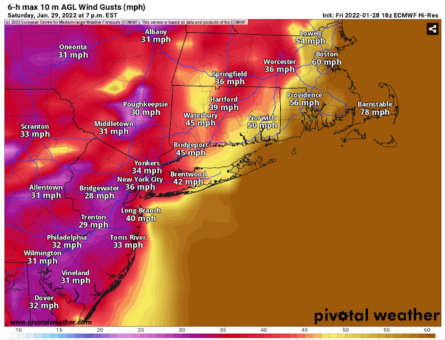
Generally, expect peak gusts of 40-60 mph in areas from the Jersey Shore along the interior areas to Maine. Eastern Long Island, eastern Connecticut, Rhode Island, and the Boston area to have gusts of 50-65 mph. Cape Cod and coastal Massachusetts will have the highest gusts of 60-70 mph. Some areas on Cape Cod will have gusts up to 75-80 mph.
To add to all this weather insanity…coastal flooding of 1-2 feet above mean water level is expected along the coast from approximately Delaware northward. This will exacerbate the overall weather situation, adding coastal flooding & storm surge to blizzard conditions.
Here is a graphic from NWS Boston summing up the situation for what will likely be the hardest-hit areas of eastern Connecticut, Rhode Island, and Massachusetts.

This will be a significant storm for New England. Stay updated on Twitter, The Weather Channel, and the National Weather Service.
HurricaneTrack.com (run by Mark Sudduth) will be live-streaming on YouTube in coastal Massachusetts. Click below to access his channel:

No comments:
Post a Comment