Thursday, February 29, 2024

Rain/Snow Mix, Localized Snow Potential Continues

FastCast--Friday, Mar. 1 to Monday, Mar. 4:

Persistent showers will continue to impact the Pacific Northwest as we begin March. With colder than normal air in place, most moderate to heavy showers have the potential to bring rain/snow mix or light snow accumulations. This is even more likely near Hood Canal and on the Kitsap Peninsula, on the region's higher hills (generally 500+ feet), and from Olympia southward. Generally, expect highs through Monday to only reach the low to mid 40s, with lows in the low to mid 30s. From Thursday night to Friday, areas from Olympia south and most areas west of Puget Sound have a potential to see brief accumulating snow. Disregarding snow, expect it to be on the wet side, with most of Western Washington receiving 0.4-0.8" of rain through Monday, with even more on the coast. The passes will likely see an additional 12-18" of snow through Monday. Stay tuned for another update Friday night as a somewhat uncertain forecast is ahead.

--------------------------------------------------------------------

Continue reading the full blog below!

A chilly and showery few days is ahead for Western Washington, and most showers have the potential of producing rain/snow mix, or brief snow in localized parts of the region. Let's take a look at the forecast!

We'll start with what I think is the most likely forecast, the NWS NBM model. This forecast is for total snow through Friday afternoon.


This forecast shows a trace to 0.5" of snow from Olympia southward, with 1-2" possible on the Kitsap Peninsula, and up to 3" around Hood Canal. Parts of the Northern WA Coast could get up to 1-2".

Next, the NAM high-resolution forecast for snow through Friday afternoon.


This forecast highlights some areas for potential snow, mainly areas west of Puget Sound and in the North Sound. One thing to note is that much of this forecasted accumulation won't happen, but this is good for seeing where a higher probability of accumulating snow exists. Be aware if you're along Hood Canal and in the hills along the WA coast.

Let's compare this to the HRRR high-resolution forecast, also showing snow through Friday afternoon.


This forecast shows the highest probability for snow is from Olympia west and south, and along the Kitsap Peninsula and Hood Canal, with a slight chance of snow for the I-5 corridor north of Olympia.

Let's take a look at temperatures. Below is the forecast for Friday morning's lows from the NAM high-resolution model.


This shows why it'll be quite hard for any real snow to accumulate in Western Washington. Lows will only reach the 32-35° range, meaning that snow has very little chance of actually sticking to anything. In Eastern Washington, expect lows in the upper 20s to low 30s, except in the mid to upper 30s for most of the Columbia Basin.

Since there is a relatively low potential for actual accumulating snow in Western Washington, most showers will be producing rain. Here's the NAM high-resolution forecast for total rain through Friday afternoon.


Expect 0.1-0.3" for most of the I-5 corridor, with the Kitsap Peninsula getting 0.3-0.6", and the coast getting 0.5-1.5", most under heavy showers.

Stay tuned for an update on Friday night, as a small low pressure system is moving into the Northwest. The forecast for this is still uncertain, so stay tuned for updates!

Tuesday, February 27, 2024

Significant Storm Bringing Strong Winds, Heavy Mountain Snow, and Heavy Rain

No FastCast tonight...continue reading the full blog below for a full briefing on the significant storm that will impact the region on Wednesday. This storm will bring strong winds, heavy mountain snow, and heavy rain to Western Washington.

Let's start with the forecast for wind gusts. Below is the NAM high-resolution forecast, showing peak winds through early Thursday morning.


This forecast shows winds peaking from around 10 AM to 9 PM, with gusts across the lowlands reaching 40-50 mph, strongest near the water. Areas around Whidbey and Camano Islands could gust over 50 mph. The coast will gust 45-50 mph, except up to 55 mph from Westport southward. This also shows gusts of 40-50 mph in the mountains, something to be prepared for, especially at higher elevations.

Let's compare this to the HRRR high-resolution forecast, also showing peak winds through early Thursday morning.


This forecast shows a similar solution for the lowlands, with gusts of 40-50 mph expected. However, this forecast has stronger winds in Island County, Western Snohomish County, and the northern Hood Canal area, with those areas gusting 50-55 mph. Similar gusts are expected on the coast.

Winds are already ramping up as I write late Tuesday night, and expect winds to peak from midmorning to late night on Wednesday. There is potential for a brief lull Wednesday evening, before the passage of the cold front around 8-10 PM.

Next, let's take a look at the forecast for mountain snow, starting with the European model, showing snow through Thursday morning.


This forecast shows 1-3 feet of snow at the passes through Thursday morning. This will bring (and is already causing) difficult driving conditions across the passes. One important note is that actual totals will likely be lower than these amounts shown since warmer air will raise the snow level to around 4,500 feet from Wednesday morning through late evening, before the snow level crashes as the cold front moves through.

Let's compare this to the HRRR high-resolution snow forecast, also through early Thursday morning.


This forecast also shows 1-3 feet of snow at the passes through early Thursday, with upwards of 5 feet expected at higher elevations such as Paradise. Remember that actual pass totals may be less than these forecasts due to the rain changeover on Wednesday.

Finally, let's take a look at the rain forecast for the lowlands. This will be quite a rainy system, with ponding, localized street flooding, and on-and-off heavy rain expected.

First, the European model forecast for total rain through early Thursday.


This forecast shows the lowlands receiving 1.5-2" of rain, with 1.5-2.5" on the coast, and a rain shadow from Everett to Bellingham, bringing lesser totals of 0.8-1.25" for that area.

Let's compare this to the NWS NBM high-resolution forecast for total rain through Thursday morning.


With a higher resolution, this forecast can pick up on features such as the rain shadow much better. As you can see, a much more defined rain shadow is seen in this forecast, with areas from Everett to the San Juans only getting 0.2-0.7" of rain. Outside that area, this forecast shows 1-1.5" of rain, except 1.5-1.75" from Olympia south and west, and for most of the Kitsap Peninsula. The coast will pick up 1.5-2" with this storm.

This is a multi-faceted storm, and wind, snow, and rain impacts are possible across the region. After this storm, the activity doesn't end, with more active weather likely over the coming days. Stay tuned and stay safe!

Monday, February 26, 2024

Monday Night Weather Update

No FastCast tonight...keep reading below for an update on lowland and mountain snow, Tuesday morning low temperatures, and the incoming heavy rain for the lowlands.

Monday was quite active across the region, mainly from Tacoma northward. Many areas received snow pellets, some areas received impactful snow pellet/hail accumulations, and the mountains received more snow. Snoqualmie Pass recorded 13" of snow today due to persistent Convergence Zone banding.

A break in precipitation is expected on Tuesday morning (some Convergence Zone bands in the North Sound will linger into early Tuesday morning), before the next system spreads rain and mountain snow into the area starting Tuesday afternoon (morning on the coast). That's where we pick up the forecast...

Let's start with the NAM high-resolution forecast, showing total snow through Wednesday evening.


This forecast highlights the potential ongoing Convergence Zone activity, showing that there's a chance of snow from Seattle/Bellevue north and east. I wouldn't believe these accumulations for the lowlands (as they are likely overdone), but that being said, you can't rule out 0.5-1" for some isolated areas under heavy snow banding.

For the mountains, expect an additional 18-30" of snow, mainly falling late Monday night through early Tuesday morning and from midday Tuesday onward, picking up in intensity through the evening. This will likely cause difficult road conditions on the passes, so be prepared!

Next, let's compare that to the HRRR high-resolution forecast, seen below.


This forecast indicates that potential Convergence Zone activity will be further south, but still very light, with isolated higher accumulations around Lynnwood and Redmond. This just represents another potential scenario for where precipitation bands set up.

In the mountains, this forecast agrees with the NAM, also showing 18-30" of new snow at the passes.

One important note for mountain snow is that from Wednesday morning to late Wednesday evening, precipitation will likely change to rain. This is most likely for Snoqualmie Pass and potentially on White Pass. Stevens Pass will most likely stay all snow on Wednesday. Precipitation will change back to heavy snow by Wednesday night, likely continuing into Thursday.

Now, let's take a look at the NWS NBM forecast for low temperatures on Tuesday morning.


Expect lows in the lowlands to reach the upper 20s to low 30s, with the coast only dropping to the mid 30s. Eastern Washington will drop into the low to mid 20s, with the lower Columbia Basin remaining in the upper 20s to low 30s. Any areas that saw precipitation on Monday have the potential for icy spots on roads on Tuesday morning, especially if frozen precipitation covered roads at any time. Be aware of this on Tuesday morning!

Finally, while a lot of the talk has been on snow lately, the lowlands are going to receive quite the rain event over the next couple days as systems bring significant rain from Tuesday afternoon to Thursday. Below is the European model forecast for total rain through Thursday evening.


In the lowlands, expect 1.75-2.5", most from Seattle southward, with a rain shadow bringing 1.25-1.75" from Everett to Bellingham. The coast will be quite sodden, with 3-4" of rain expected. 

We will cover the upcoming storms more in Tuesday night's blog, so stay tuned! 

Sunday, February 25, 2024

Update on Potential Localized Snow and Chance of Thunderstorms

No FastCast tonight...keep reading below for an update on the potential localized lowland snow and a chance of thunderstorms on Monday.

Here's the overall setup for Monday: Convergence Zone bands and post-frontal showers will combine with a colder airmass to produce localized snow showers and potentially snow pellets. There is also a chance of thunderstorms, mainly in the afternoon. Any afternoon showers could produce an isolated lightning strike.

Let's start with the snow forecast from the NAM high-resolution model. This goes through early Tuesday morning.


This forecast shows some Convergence Zone bands producing 0.25-0.5" of snow from Lakewood to Puyallup, from North Seattle east to Kirkland, and a more robust area of snow from Everett to Bellingham, with 1-3" possible. I'd expect those higher totals to be confined to higher hills and heavier showers.

As you can sese, the mountains will also receive a huge amount of snow, with 1-2 additional FEET possible at the passes.

Next, let's take a look at the HRRR forecast, which shows more snow than the NAM, representing a colder and somewhat snowier scenario.


This forecast shows areas from Olympia southward getting 1-3" of snow (somewhat possible, not very likely). Areas from Tacoma to Seattle could get 0.25-1" in this forecast, with areas from Shoreline to Marysville getting 1-2", and areas from Marysville northward getting 0.3-1". This forecast likely overdoes snow for the entire region, so I wouldn't expect this to happen, but it is still within the realm of possibility.

Now, let's switch gears and take a look at the thunderstorm potential for Monday afternoon. Below is the HRRR forecast for CAPE (measure of instability in the atmosphere) on Monday afternoon.


This forecast shows CAPE values of 100-375 across the lowlands, which is enough for an isolated lightning strike around the region. The NAM high-res forecast (not shown) has much higher CAPE values, showing that instability will definitely be elevated across the region.

To see if these forecasts are on to something, we can look at the European model forecast for lightning flash density (a forecast of where lightning could strike). The image below is for early Monday afternoon.


This forecast shows a decent lightning potential for the South and Central Sound. Remember, any showers on Monday have the potential for thunder & lightning, plus snow pellets (sometimes incorrectly known as graupel) and even brief snow.

Stay safe out there on Monday (especially in the mountains), and if you are on Twitter/X, feel free to tag me (@The_Weatherman2) and report what kind of weather you're seeing!

Saturday, February 24, 2024

Heavy Snow, Gusty Winds, and Lowland Rain Ahead

 FastCast--Sunday, Feb. 25 to Monday, Feb. 26:

The first storm of the more active weather pattern is slated to impact the region from Sunday to Monday. For the lowlands, expect gusty winds (30-40 mph, strongest near the water), with the strongest winds gusting 40-50 mph from Everett to Mount Vernon and especially around Admiralty Inlet. The lowlands will receive 0.25-0.75" of rain, with a rain shadow giving less rain (0.1-0.2") from Everett to Seattle. In the mountains, expect significant snow through Monday, with the passes receiving 1-2 feet of snow, except up to 3 feet at Stevens Pass. Travel will be quite difficult, although rain will not change to snow at Snoqualmie Pass until Sunday evening, lessening totals around the summit. Stay tuned for another update Sunday evening, as an uncertain forecast for potential localized lowland snow is ahead for Monday.

------------------------------------------------------------------------

Continue reading the full blog below!

A significant mountain snowstorm is ahead, in addition to gusty winds and another round of rain. 

Let's take a look at the snow forecast, starting with the high-resolution NAM forecast for total snow through early Monday morning.


This forecast shows 1-2 feet of snow at the passes, with up to 3 feet at Stevens Pass. This snow, in addition to gusty winds, will create dangerous conditions at times across the passes. One thing to note is that Snoqualmie Pass will likely be all rain until Sunday night, potentially lessening totals there. 

Let's compare this to the HRRR high-resolution forecast, also showing snow through early Monday morning.


This forecast agrees with 1-2 feet at the passes, and up to 3 feet at Stevens Pass. With this forecast and the NAM high-resolution forecast, there is a potential for lowland snow early Monday. Stay tuned for an update on Sunday night regarding this potential.

Next, let's take a look at the wind forecast, starting with the NAM high-resolution forecast.


This forecast shows gusts of 30-40 mph from Everett southward and on the coast. A westerly surge down the Strait of Juan de Fuca will extend down Admiralty Inlet, bringing gusts of 40-50 mph to Island County and western Snohomish County. Eastern Washington will have widespread gusts of 40-50 mph. Additionally, note the gusts of 45-60 mph in the Cascades and along ridgetops, which will create blowing snow at times, and potentially dangerous travel conditions on the passes.

Let's compare this to the HRRR forecast, also showing wind gusts.


This forecast has stronger winds, with the lowlands and coast gusting 35-40 mph, and areas from Edmonds northward gusting 40-45 mph. Island, eastern Jefferson, and western Snohomish Counties will gust 45-55 mph in this forecast, which could potentially cause impacts on Southern Whidbey Island and from Everett to Arlington. The passes and other locations in the Cascades hit 45-50 mph in this forecast, with backcountry ridgetops gusting 60-70 mph (luckily, no one should be out there!). Eastern Washington hits 45-50 mph, except up to 55 mph around the Palouse.

Finally, let's take a look at the total rain forecast through Monday morning, from the European model.


Expect 0.1-0.2" from Seattle to Everett, east to Bremerton, and north to Sequim. From Tacoma south, expect 0.3-0.6" of rain, with 0.7-1.2" from Everett northward and on the coast.

Stay tuned for an update on Sunday night regarding the potential localized lowland snow forecast for Monday, and stay safe out there!

Thursday, February 22, 2024

Significant Pattern Change Ahead

 FastCast--Friday, Feb. 23 to Monday, Feb. 26:

After a calm and relatively benign month, a significant pattern change will bring active weather back to the Northwest. However, a couple dry and calm days are ahead before the pattern changes. On Friday, expect a beautiful day, with mostly sunny skies and highs in the mid 50s. Morning lows will be chilly, likely in the low to mid 30s across the lowlands. Clouds will arrive on Saturday, with overcast skies, highs in the upper 40s to low 50s, and lows in the low 40s. The first storm arrives on Sunday, with 0.25-0.6" of rain across the lowlands (up to 1" from Skagit County northward), and heavy mountain snow, totaling 10-24" at the passes (heaviest Sunday afternoon through early Monday morning). Stevens Pass will likely get the heaviest totals (up to 30"). Additionally, the region will be breezy to windy on Sunday, especially around Whidbey and Camano Islands (and potentially western Snohomish County) due to a westerly surge down the Strait of Juan de Fuca, which will bring gusts of 45-55 mph. The remainder of the area will likely gust 30-40 mph, strongest near the water. Conditions will calm on Monday, with some lingering showers, as we have a break between storms. Much more active weather is expected next week, so stay tuned.

------------------------------------------------------------

Continue reading the full blog below!

A major pattern change is ahead for the Northwest, with heavy mountain snow, another round of rain, and gusty winds. Let's take a look at the forecast!

We'll start with mountain snow...the forecast below is through Monday morning, from the European model.


This forecast shows 10-20" of snow at Snoqualmie and White Passes, with up to 30" at Stevens Pass. The heaviest snow is likely from late Sunday afternoon to early Monday morning, and may be accompanied by strong winds. Also note that any potential lowland snow is still far too uncertain at this time.

Let's compare this to the higher-resolution NWS NBM forecast, also showing snow through early Monday morning.


This forecast agrees, with 10-20" of snow at all the passes, with up to 25" at Stevens Pass. Again, don't focus on any potential lowland snow, as that is far too uncertain.

Now, let's take a look at the wind forecast, specifically for Whidbey and Camano Islands, from the European model.


Notice the westerly wind surge that impacts Whidbey and Camano Islands, along with Western Snohomish County. Areas from Port Angeles to Arlington and from Anacortes to Everett could see gusts of 45-55 mph, strongest on Whidbey and Camano Islands. This forecast also shows winds gusting 40-50 mph at the Cascade passes, which will be happening as snow falls, creating hazardous winter storm conditions.

For the best weather updates from Whidbey Island, follow my friend Jonathan Pulley's Whidbey Island Weather Facebook Group.

Let's compare this forecast to the NWS NBM wind forecast, seen below.


This forecast also shows stronger winds around Island County, plus gusts of 35-40 mph across the Puget Sound area. Additionally, this forecast shows gusts of 40-45 mph across Eastern Washington, with gusts up to 50 mph in the Cascades, which could create dangerous winter storm conditions.

Finally, let's take a look at the rain forecast through Monday morning, starting with the European model.


Generally, expect 0.25-0.5" in the lowlands, with up to 1" from Everett northward. The coast could get 0.6-1.25" with this system. (Don't forget...all of that is snow in the mountains).

Let's get a higher-resolution version of this forecast from the NWS NBM forecast below, also showing total rain through Monday morning.


This forecast shows a bit more rain for the lowlands, with totals of 0.4-0.7", and 0.7-1.3" for the coast. Note the incredible rain shadow effect of the Cascades! It's very cool to look at in forecast graphics!

Much more active weather is likely next week, including heavy rain, major mountain snow, and potential lowland snow. Stay tuned!

Monday, February 19, 2024

Rain Continues, Update on Snowpack & Extended Forecast

FastCast--Tuesday, Feb. 20 to Friday, Feb. 23:

As a system swirls offshore of the Pacific Northwest, multiple rounds of precipitation will move through the region. Expect showers at times from Tuesday to Wednesday, bringing 0.4-0.8" of rain to the lowlands, with isolated higher amounts. The mountain passes will only receive 2-4" of snow with this system. On Tuesday and Wednesday, expect temperatures in the mid 50s (Tuesday) and upper 40s to low 50s (Wednesday). On Thursday and Friday, conditions will dry out, and temperatures will increase, with highs reaching the mid to upper 50s. Through the entire week, lows will be in the upper 30s to low 40s. A pattern change to colder, wetter, and more active weather is possible by early next week, so stay tuned for more information.

-----------------------------------------------------------------

Continue reading the full blog below!

Multiple rounds of rain are likely for the Northwest as a system that has brought active weather to California swirls off the Northwest coast. Let's take a look at the forecast!

Below is the European model forecast for total rain through late Wednesday.


This forecast shows 0.5-0.9" of rain for the lowlands, with isolated areas getting up to 1". The coast gets 0.7-1.25" in this forecast, with scattered totals of 0.1-0.4" across Eastern Washington.

Let's compare this to the high-resolution NAM forecast, seen below, also showing total rain through late Wednesday.


This forecast shows 0.3-0.6" of rain for the lowlands, with isolated areas getting up to 0.8-1". The coast would get 0.4-0.9", most on the central coast. This forecast also shows some rain in Eastern Washington, mainly 0.1-0.3" near the Cascades and north of I-90.

Next, let's take a look at the somewhat lackluster snow forecast with this system, seen below on the European model.


This forecast shows only 1-4" of total snow for the passes, with higher elevations such as Paradise and Mount Baker only getting 5-10" additional snow. 

This is not great news for the below-average snowpack across the Cascades and Olympics. Below is the Washington snowpack data from the USDA NRCS site, as of February 16th.


Snowpack in the Cascades sits at 45-80% of normal, while the Olympics are only at around 30% of normal. 

These snowpack numbers are not very good, and it would be concerning to see numbers like this continue into spring. However, we may see positive change in snowpack with a potential pattern change ahead. 

Let's take a look at the extended outlooks from the NWS Climate Prediction Center (CPC) for the final week of February.

First, the temperature outlook.


This outlook shows the Central and Eastern US being dominated by significant warmth, while the Northwest has a 40-50% probability of below average temperatures to end February.

Now, let's take a look at the CPC precipitation outlook.


Paired with potential below-average temperatures, this is a great signal. This outlook shows a 50-60% probability of above average precipitation for the Northwest through the end of February. 

Stay tuned for more information on the upcoming pattern change (and some potential warmer days near the end of this week)!

Thursday, February 15, 2024

Next Round of Gap Winds Ahead

 FastCast--Friday, Feb. 16 to Tuesday, Feb. 20:

After a complex system that produced areas of snow and gusty gap winds, another round of strong easterly offshore winds is ahead across the region. Near the foothills, especially around North Bend, Enumclaw, and Gold Bar, expect gusts of 45-55 mph. Isolated areas, mainly on backcountry ridgetops, could reach 60+ mph. Lowland locations from the King/Pierce County line north to the Everett area, and then north of Bellingham, will have gusts of 30-40 mph. These winds will likely be strongest between Federal Way and Seattle, extending west toward Bainbridge Island and east to the foothills. Coastal areas will also be impacted by offshore winds gusting 40-50 mph, strongest around the Willapa Bay area. Outside of wind impacts, expect a chilly morning on Friday, with the lowlands dropping to the upper 20s to low 30s. After peaking on Friday evening, gap winds will ease on Saturday. Expect off-and-on light rain from late Saturday through Tuesday. Additionally, expect highs in the low to mid 50s, with lows in the upper 30s to low 40s. Conditions through Tuesday will be partly to mostly cloudy.

----------------------------------------------------------------------

Continue reading the full blog below!

Another round of gap winds is ahead for Western Washington, and this round will be stronger than the winds on Wednesday night and Thursday morning. Let's take a look at the forecast! (Cold temperatures statewide on Friday morning...forecast at bottom!)

First, we'll take a look at the NAM high-resolution forecast, showing peak wind gusts through Saturday.


This forecast shows very strong gusts over the Cascades and in the immediate foothills, with 45-55 mph gusts possible for North Bend, Enumclaw, and Gold Bar, with gusts over 60 mph for remote ridgetops. This forecast also shows gusts of 40-50 mph from Kent to Shoreline, with an area of 50-55 mph gusts from Renton to Issaquah. Lesser areas of gap winds are found around Chehalis (gusts up to 35-40 mph) and north of Bellingham (35-40 mph). The coast will have offshore winds gusting 40-50 mph, with isolated areas of stronger gusts possible in Pacific County.

This forecast is on the higher side of what's possible, but is definitely within the realm of possibility. One thing to note is that there is usually a sharp cutoff on the southern edge of gap winds in the Puget Sound area.

Let's compare this to the HRRR high-resolution forecast, seen below.


This forecast shows slightly lesser winds, with the foothills (such as North Bend, Enumclaw, and Gold Bar) gusting 45-55 mph, and gusts from roughly Kent to Everett reaching 35-40 mph. Areas from Renton eastward could reach 40-45 mph. Additionally, expect gusts of 40-50 mph on the coast, strongest in Pacific County.

Gap winds frequently cause power outages in the Cascade foothills and areas between I-5 and the foothill region. Whenever gap winds could reach 40+ mph, be prepared for tree damage and power outages.

So, what is causing these gap winds? The answer can be found below, in the NAM high-resolution forecast for surface pressure.


Notice how pressure is higher (darker red/brown) east of the Cascades, and lower (lighter orange/red) west of the Cascades. A strong cross-Cascade pressure gradient is what fuels gap winds. On Friday evening, the gradient between Seattle and Wenatchee (a key measurement for gap winds) will be approaching 8-12 millibars, a decent gradient that is a sign of potentially strong gap winds.

Finally, let's take a look at the forecast low temperatures across Washington on Friday morning. With relatively clear skies and a somewhat colder airmass, temperatures will get below freezing for most of the state. The European model forecast for Friday morning's lows is seen below.


Expect lows in the mid 20s to low 30s for the lowlands (colder in areas sheltered from easterly winds). The coast and Willamette Valley will only drop to the mid 30s. In Eastern Washington, expect lows in the upper teens to mid 20s, with mountain towns dropping to the upper single digits to mid teens. 

Stay safe and stay warm!

Wednesday, February 14, 2024

Update: Gap Winds and Marginal Snow Potential

No FastCast tonight...below is an update on the snow and gap wind situation. 

As of 10:30 PM, there have been reports of rain/snow mix from Federal Way to Olympia, with snow falling on the Kitsap Peninsula, on SR-8 west of Olympia, and even some flakes near Westport due to heavy precipitation rates. Let's take a look at the snow forecast!

Below is the high-resolution NAM forecast, showing total snow through Thursday.


This forecast shows a dusting to 0.5" of snow for Olympia and areas from Everett to Bellingham, plus the coast from Grays Harbor County northward. The Kitsap Peninsula, Hood Canal area, and Shelton area could get 1.5-3" of snow, with isolated higher amounts possible. 

Let's compare this to the HRRR forecast, which shows even more snow.


This forecast shows no snow north of Olympia for the I-5 corridor, but shows 1-2" from Chehalis to Olympia, and 4-6" for the Kitsap Peninsula, Shelton, and Hood Canal, with isolated totals of 6-8" on the higher hills of the Kitsap Peninsula. This forecast also shows up to 1" of snow around Grays Harbor. 

Both forecasts are possible, and there is still a chance that areas along the I-5 corridor and north of Everett receive snow overnight and into the morning. The tricky thing is how marginal temperatures are with this event. Snow is most likely on higher hills, away from the water, and in areas not exposed to gusty east winds.

Speaking of gusty easterly gap winds, let's take a look at the high-resolution forecasts for winds. Below is the NAM high-resolution forecast for peak winds through Thursday.


This forecast shows gap winds gusting up to 50 mph for North Bend, Enumclaw, Gold Bar, and the coast, where offshore winds could reach 50 mph, especially around Grays Harbor. Lowland areas from the King/Pierce County line northward to Seattle, and from Everett to Arlington, could be impacted by easterly winds gusting up to 40 mph, peaking early Thursday morning. The areas between I-5 and the Cascades, from Seattle to Tacoma, could gust up to 45 mph.

Let's compare this to the HRRR forecast, seen below.


This forecast is a bit more tame for winds, with the gaps, coast, and lowland areas from Tacoma to Seattle gusting 35-40 mph, except up to 45-50 mph near North Bend, Enumclaw, and Gold Bar. 

Either forecast is possible, with the most likely scenario being between the two. 

Be prepared for winter weather impacts if you are on the Kitsap Peninsula, around Hood Canal, and around Shelton. A Winter Storm Warning is in effect for those areas through Thursday morning for up to 6" of snow. Stay safe out there!

Tuesday, February 13, 2024

Difficult Forecast for Localized Lowland Snow and Gap Winds

No FastCast tonight...we're going to focus on the difficult and marginal forecast for the Wednesday evening to Thursday morning weather system.

There is a somewhat complex forecast coming up, as a low moves northward parallel to the Washington coast, spreading precipitation northward through Western Washington.

This system has three main players: precipitation, easterly gap winds, and temperatures.

As precipitation moves northward, it will cool the atmosphere through the process of evaporative cooling, where heavier precipitation essentially removes heat from the atmosphere and brings about cooling. This could bring localized snow accumulations to parts of the region. However, easterly gap winds will dry out the region, and with gap winds moving in from the Fraser River gap and along the Cascade foothills, the I-5 corridor's snow potential goes down significantly due to the influx of dry air. Gap winds will likely increase Wednesday afternoon and peak early Thursday morning, before subsiding through the day. Finally, temperatures are on the edge, which instantly limits snow accumulations to non-road surfaces.

Let's take a look at the forecast and see how this all plays out. A key reminder...temperatures will be hovering at 32-36°, and areas of heavier precipitation are what will bring down temperatures more. So, just because snow is shown on the forecast at your location, doesn't mean it will actually happen.

First, the NAM high-resolution model forecast for snow through Thursday.


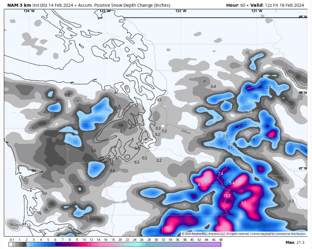
This forecast shows positive change in snow depth, basically what would actually stick to the surface, which is a good measure to use in marginal events. Notice how this shows no snow to 0.3" for the metro area (since the snow is being eaten by gap winds), with up to 1" around Olympia, and 1" or so around Hood Canal and the Kitsap Peninsula. It's reasonable to think that more snow could accumulate on some surfaces, but this is a good determination of a marginal event.

The European model has a much higher-end event, as seen in the snow accumulation forecast below.


The European model is stuck in a much snowier scenario, which shows 1-3" from Everett southward, and up to 3-5" for the Kitsap Peninsula and Hood Canal areas. However, notice how there are areas of lesser snow between the Cascades and Puget Sound...an indication of drying gap winds. This scenario is possible, but far less likely. Don't expect multiple inches of snow anywhere outside the Kitsap Peninsula and Hood Canal area.

Finally, let's compare this to the HRRR high-resolution model, seen below.


This forecast is very pessimistic for any lowland snow, which makes sense as it shows the strongest gap winds. However, note 0.5-2" of snow for the Kitsap Peninsula (west of Bremerton) and the Hood Canal area.

As you can see, this is a very marginal snow situation, and little changes in drying winds and temperatures can have a large impact. Stay tuned for a short update Wednesday afternoon by 3 PM on the latest forecasts.

Next, let's take a look at the high-resolution forecasts for gap winds, starting with the NAM forecast for maximum wind gusts through Thursday.


This forecast shows winds near North Bend, Enumclaw, and Gold Bar gusting 40-50 mph, with east winds gusting up to 45 mph on the coast. An area of 35-45 mph gusts exists from roughly Federal Way to Seattle and eastward into the foothills, and power outages and some tree damage is possible should this verify. Also, with gusty gap winds expected, any snow falling on the passes could easily obstruct visibility and lead to brief white-out conditions on Thursday. Additionally, expect gusty NE outflow winds of 40-45 mph for Whatcom County, mainly north of Bellingham.

Let's compare to the HRRR forecast for winds through Thursday.


This forecast is nearly identical to the NAM, but shows a larger area of easterly winds extending into the lowlands. This shows gusts of 40-45 mph from the King/Pierce County line north to Shoreline, with winds extending as far west as Port Orchard. Again, these easterly winds can cause power outages, so be prepared. 

Finally, let's take a look at the total rain through Thursday from the NAM forecast, seen below.


Expect 0.1-0.3" for the lowlands from Tacoma to Everett, with 0-0.1" from Everett north, and 0.3-0.8" from Tacoma southward. The Cascade foothills could get 0.05-0.15", due to the gap winds. The coast will get up to 1.25". The Kitsap Peninsula and Hood Canal area will get 0.3-0.75", although some may fall as snow. Notice how the gap winds eat up precipitation, as there is less rain between the Cascades and Puget Sound due to the drying effect of the gap winds.

Should gap winds be weaker than the NAM forecasts, precipitation totals would be higher.

Remember to stay tuned for a short forecast update by 3 PM Wednesday. (If you are on Twitter/X, stay tuned for more frequent updates!)

Short Spring Heat Wave for the Pacific Northwest

  FastCast--Thursday, May 9 to Tuesday, May 14: A spring "heat wave" is ahead for the Northwest, with the warmest temperatures see...