FastCast--Friday, Feb. 23 to Monday, Feb. 26:
After a calm and relatively benign month, a significant pattern change will bring active weather back to the Northwest. However, a couple dry and calm days are ahead before the pattern changes. On Friday, expect a beautiful day, with mostly sunny skies and highs in the mid 50s. Morning lows will be chilly, likely in the low to mid 30s across the lowlands. Clouds will arrive on Saturday, with overcast skies, highs in the upper 40s to low 50s, and lows in the low 40s. The first storm arrives on Sunday, with 0.25-0.6" of rain across the lowlands (up to 1" from Skagit County northward), and heavy mountain snow, totaling 10-24" at the passes (heaviest Sunday afternoon through early Monday morning). Stevens Pass will likely get the heaviest totals (up to 30"). Additionally, the region will be breezy to windy on Sunday, especially around Whidbey and Camano Islands (and potentially western Snohomish County) due to a westerly surge down the Strait of Juan de Fuca, which will bring gusts of 45-55 mph. The remainder of the area will likely gust 30-40 mph, strongest near the water. Conditions will calm on Monday, with some lingering showers, as we have a break between storms. Much more active weather is expected next week, so stay tuned.
------------------------------------------------------------
Continue reading the full blog below!
A major pattern change is ahead for the Northwest, with heavy mountain snow, another round of rain, and gusty winds. Let's take a look at the forecast!
We'll start with mountain snow...the forecast below is through Monday morning, from the European model.

This forecast shows 10-20" of snow at Snoqualmie and White Passes, with up to 30" at Stevens Pass. The heaviest snow is likely from late Sunday afternoon to early Monday morning, and may be accompanied by strong winds. Also note that any potential lowland snow is still far too uncertain at this time.
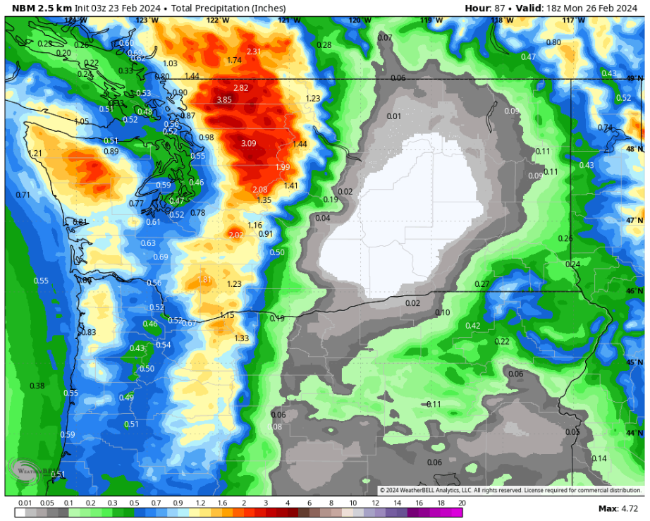
Let's compare this to the higher-resolution NWS NBM forecast, also showing snow through early Monday morning.

This forecast agrees, with 10-20" of snow at all the passes, with up to 25" at Stevens Pass. Again, don't focus on any potential lowland snow, as that is far too uncertain.
Now, let's take a look at the wind forecast, specifically for Whidbey and Camano Islands, from the European model.

Notice the westerly wind surge that impacts Whidbey and Camano Islands, along with Western Snohomish County. Areas from Port Angeles to Arlington and from Anacortes to Everett could see gusts of 45-55 mph, strongest on Whidbey and Camano Islands. This forecast also shows winds gusting 40-50 mph at the Cascade passes, which will be happening as snow falls, creating hazardous winter storm conditions.
For the best weather updates from Whidbey Island, follow my friend Jonathan Pulley's Whidbey Island Weather Facebook Group.
Let's compare this forecast to the NWS NBM wind forecast, seen below.

This forecast also shows stronger winds around Island County, plus gusts of 35-40 mph across the Puget Sound area. Additionally, this forecast shows gusts of 40-45 mph across Eastern Washington, with gusts up to 50 mph in the Cascades, which could create dangerous winter storm conditions.
Finally, let's take a look at the rain forecast through Monday morning, starting with the European model.

Generally, expect 0.25-0.5" in the lowlands, with up to 1" from Everett northward. The coast could get 0.6-1.25" with this system. (Don't forget...all of that is snow in the mountains).
Let's get a higher-resolution version of this forecast from the NWS NBM forecast below, also showing total rain through Monday morning.
This forecast shows a bit more rain for the lowlands, with totals of 0.4-0.7", and 0.7-1.3" for the coast. Note the incredible rain shadow effect of the Cascades! It's very cool to look at in forecast graphics!
Much more active weather is likely next week, including heavy rain, major mountain snow, and potential lowland snow. Stay tuned!

No comments:
Post a Comment