No FastCast tonight...we're going to focus on the difficult and marginal forecast for the Wednesday evening to Thursday morning weather system.
There is a somewhat complex forecast coming up, as a low moves northward parallel to the Washington coast, spreading precipitation northward through Western Washington.
This system has three main players: precipitation, easterly gap winds, and temperatures.
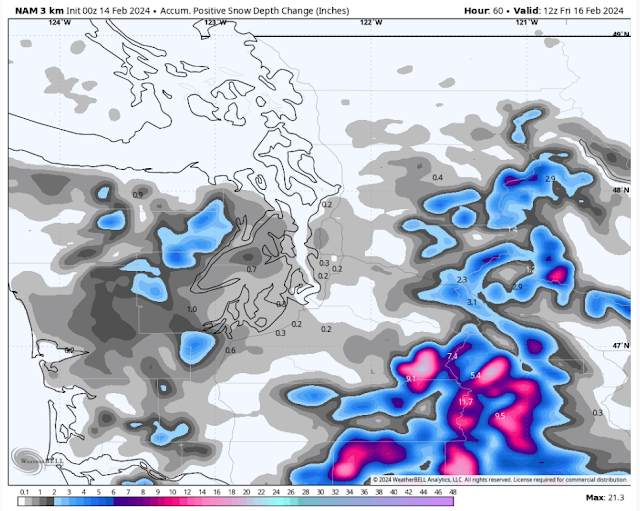
As precipitation moves northward, it will cool the atmosphere through the process of evaporative cooling, where heavier precipitation essentially removes heat from the atmosphere and brings about cooling. This could bring localized snow accumulations to parts of the region. However, easterly gap winds will dry out the region, and with gap winds moving in from the Fraser River gap and along the Cascade foothills, the I-5 corridor's snow potential goes down significantly due to the influx of dry air. Gap winds will likely increase Wednesday afternoon and peak early Thursday morning, before subsiding through the day. Finally, temperatures are on the edge, which instantly limits snow accumulations to non-road surfaces.
Let's take a look at the forecast and see how this all plays out. A key reminder...temperatures will be hovering at 32-36°, and areas of heavier precipitation are what will bring down temperatures more. So, just because snow is shown on the forecast at your location, doesn't mean it will actually happen.
First, the NAM high-resolution model forecast for snow through Thursday.
The European model has a much higher-end event, as seen in the snow accumulation forecast below.
The European model is stuck in a much snowier scenario, which shows 1-3" from Everett southward, and up to 3-5" for the Kitsap Peninsula and Hood Canal areas. However, notice how there are areas of lesser snow between the Cascades and Puget Sound...an indication of drying gap winds. This scenario is possible, but far less likely. Don't expect multiple inches of snow anywhere outside the Kitsap Peninsula and Hood Canal area.
Finally, let's compare this to the HRRR high-resolution model, seen below.
This forecast is very pessimistic for any lowland snow, which makes sense as it shows the strongest gap winds. However, note 0.5-2" of snow for the Kitsap Peninsula (west of Bremerton) and the Hood Canal area.
As you can see, this is a very marginal snow situation, and little changes in drying winds and temperatures can have a large impact. Stay tuned for a short update Wednesday afternoon by 3 PM on the latest forecasts.
Next, let's take a look at the high-resolution forecasts for gap winds, starting with the NAM forecast for maximum wind gusts through Thursday.
This forecast shows winds near North Bend, Enumclaw, and Gold Bar gusting 40-50 mph, with east winds gusting up to 45 mph on the coast. An area of 35-45 mph gusts exists from roughly Federal Way to Seattle and eastward into the foothills, and power outages and some tree damage is possible should this verify. Also, with gusty gap winds expected, any snow falling on the passes could easily obstruct visibility and lead to brief white-out conditions on Thursday. Additionally, expect gusty NE outflow winds of 40-45 mph for Whatcom County, mainly north of Bellingham.
Let's compare to the HRRR forecast for winds through Thursday.
This forecast is nearly identical to the NAM, but shows a larger area of easterly winds extending into the lowlands. This shows gusts of 40-45 mph from the King/Pierce County line north to Shoreline, with winds extending as far west as Port Orchard. Again, these easterly winds can cause power outages, so be prepared.
Finally, let's take a look at the total rain through Thursday from the NAM forecast, seen below.
Expect 0.1-0.3" for the lowlands from Tacoma to Everett, with 0-0.1" from Everett north, and 0.3-0.8" from Tacoma southward. The Cascade foothills could get 0.05-0.15", due to the gap winds. The coast will get up to 1.25". The Kitsap Peninsula and Hood Canal area will get 0.3-0.75", although some may fall as snow. Notice how the gap winds eat up precipitation, as there is less rain between the Cascades and Puget Sound due to the drying effect of the gap winds.
Should gap winds be weaker than the NAM forecasts, precipitation totals would be higher.
Remember to stay tuned for a short forecast update by 3 PM Wednesday. (If you are on Twitter/X, stay tuned for more frequent updates!)


Sounds like we will just wait and see what we get.
ReplyDelete