FastCast—Monday, Feb. 5 to Thursday, Feb. 8:
Calm weather will continue for the Pacific Northwest as a major storm persists in California. Cloudy conditions will return to Western Washington on Monday, lasting through the week. Expect a chance of showers, mainly from Monday to Tuesday, early on Wednesday, and late Thursday night. These showers will total 0.2-0.5” of rain across the region. Additionally, expect 2-6” of snow at the passes, scattered throughout the week. In the lowlands, expect seasonable temperatures, with highs in the mid to upper 40s and lows in the mid to upper 30s. Keep reading below for information about the ongoing California storm.
——————————————————————
Continue reading the full blog below!
A major storm is ongoing across California, bringing a plethora of significant impacts. Let’s take a look at the forecast, and what’s happened so far.
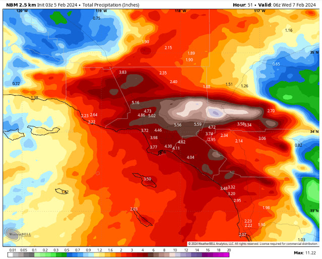
Below is the high-resolution NAM forecast for total rain in Southern California through late Tuesday.
This forecast shows a staggering 4-7” of rain across the Los Angeles metro area, with up to 10-20” in the Transverse Range Mountains north and west of LA. This will bring damaging flash flooding should this solution verify.
Let’s compare this to the NWS NBM forecast, also showing rain through late Tuesday.
This forecast also shows 4-6” of rain for the LA metro, with 7-12” for the Transverse Ranges. This is still a staggering amount of rain that will undoubtedly cause major flood concerns.
Lastly, here’s the ever-reliable European model forecast, showing the cause of this major rain and flood event.
This shows the amount of water vapor in the atmosphere, and you can clearly see that the atmospheric river is slamming the Los Angeles metro area and the Transverse Ranges. You really can’t have a more direct hit from an atmospheric river than this.
Due to the incredibly dangerous flash flooding potential from this atmospheric river, the NWS Weather Prediction Center (WPC) has issued the highest possible excessive rainfall & flash flooding risk for much of Southern California. Below is the risk map for flash flooding.
The entire California coast from San Francisco southward has a moderate risk of flash flooding (40% chance), with an extreme high risk (70% chance) of flash flooding from Point Conception to Orange County, and north into the Transverse Ranges. Saying that the flash flooding potential is dangerous would be an understatement.
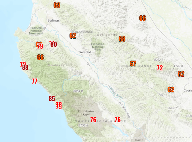
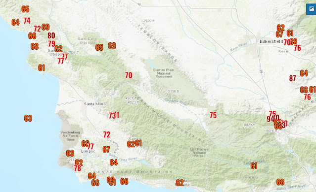
Finally, below is a look at 60+ mph wind gusts across Central and Southern California. Numerous locations recorded 80-105 mph gusts, mainly mountain locations. Many coastal and valley locations, including San Francisco, recorded gusts of 60-75 mph. The sheer amount of 60+ mph gusts (even more than what’s seen on this map) likely makes this one of the most significant windstorms in recent history for California. As of the publishing of this blog at 11:00 PM Sunday, there are over 750,000 customers out of power in California.
The maps below show 60+ mph gusts from north to south.


No comments:
Post a Comment