FastCast—Saturday, Feb. 3 to Wednesday, Feb. 7:
The Northwest is cooling down following an abnormally warm past week. Through the middle of next week, expect lowland highs in the mid 40s to low 50s, with lows in the mid 30s to low 40s. Conditions will be partly to mostly cloudy, with overcast conditions from Monday onward. There’s a chance of showers from Monday evening through Wednesday, but little rain is expected. Keep reading below for a look at the major storm that will be impacting California, plus a look at the forecast for WA (below the California information).
—————————————————————
Continue reading the full blog below!
While mostly cloudy, cool, and relatively benign weather returns to the Pacific Northwest, a major, high-impact storm is heading for California. The storm will consist of a very strong atmospheric river, massive snow totals in the Sierra Nevada, and strong winds. With relatively little going on in the PNW, let’s take a look at the forecast for California.
First, below is the European model forecast for rain through Tuesday morning across Southern California.

This is a staggering amount of rain to fall within 3 days. Most areas from Santa Barbara to San Diego will receive 3-5” of rain, with up to 8” in the mountains around Los Angeles. This will bring widespread flooding, especially on roads and in streams and creeks. River flooding is possible as well. This amount of rain would cause impacts in Seattle, so just imagine what can happen in the LA metro!
Next, let’s take a look at the reason this storm is happening. Below is the European Ensemble forecast for precipitable water (amount of water vapor in the atmopshere) on Sunday.

That is a firehose of moisture pointed right at Central and Southern California. It’s safe to say that it’ll be a very potent atmospheric river.
This atmospheric river won’t just produce rain. It will also bring a huge snowstorm to the Sierra Nevada. Below is the snow forecast through Tuesday morning from the European model.

Wow! Expect staggering amounts of 2-6 FEET of snow through Tuesday. Dinner Pass, which carries I-80 between Sacramento and Reno, will be significantly impacted, with up to 4 feet of snow through Tuesday. Additionally, the mountains of Northern California could receive 1-3 feet of snow, bringing potential impacts to I-5, especially from Medford, OR to Redding.
Finally, let’s take a look at the third facet of this storm…the wind potential. The European model forecast for peak gusts through Tuesday is seen below.

The strongest winds will be confined to the coast, roughly from Point Arena southward. Coastal gusts will range from 50-70 mph, strongest from San Francisco to Point Conception. The Central Valley, Sierra Nevada, and parts of the LA metro will gust 40-50 mph.
Altogether, the major rain, strong winds, and massive snow will create significant weather impacts for a large portion of California. If you or someone you know is in impacted areas, be prepared!
Now, back to the Northwest…temperatures are dropping noticeably from the abnormally warm past week. Below is the NWS NBM forecast for highs on Saturday.

Most areas west of the Cascades will reach the mid 40s to low 50s, with Eastern WA reaching the upper 30s to upper 40s. The coast will be in the low 50s.
Low temperatures will also be noticeably cooler, as seen below in the NWS NBM forecast.

Lows will drop to the mid 30s to low 40s for Western Washington, and the low to mid 30s for the Willamette Valley. Eastern Washington will drop to the low to mid 30s, with the mountains dropping to the low to mid 20s. Morning lows will slowly decrease through the next few days.
Finally, below is the European Ensemble forecast for temperatures in Seattle over the next few days.
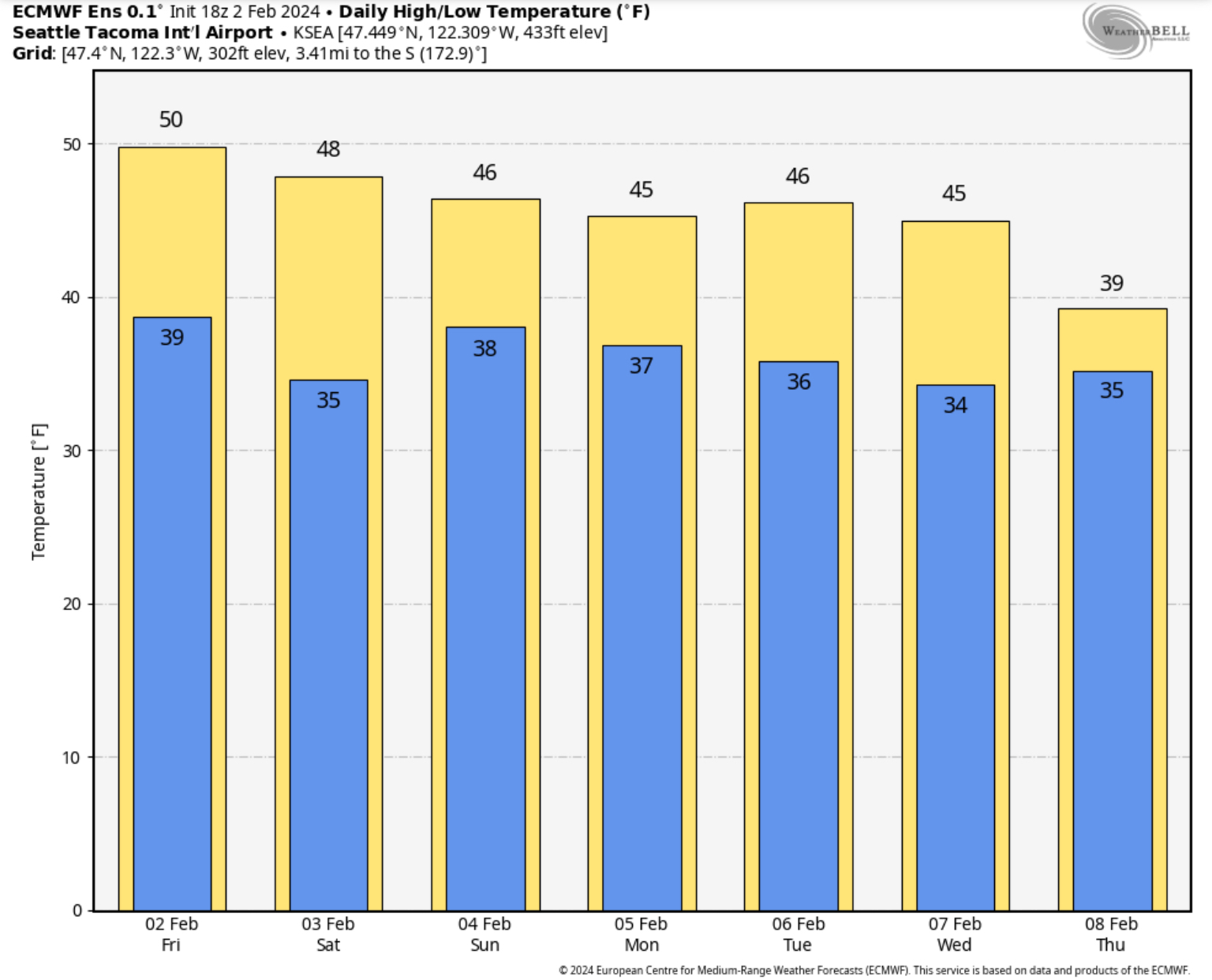
Over the next few days, high temperatures will decrease to the mid 40s, with lows dropping to the mid 30s. These are more seasonable temperatures for February.

No comments:
Post a Comment