Friday, February 26, 2021

Calm Weekend Ahead

Thursday and Friday were breezy, and windy at times, across Puget Sound, especially south of Seattle. Take a look at Thursday’s peak gusts below.


Gusts of 30-45 mph were common around the area, peaking late Thursday.

Friday was sunny at times with breezy conditions, mainly early in the morning and late in the afternoon.

Friday night will be chilly, with lows of 30-35 degrees. Below is the Puyallup forecast from Weather Underground.


Highs will climb to the low 50s by Sunday. Temperatures recently have been below average, a trend that will continue through the beginning of March.

The graph below from the NWS Climate Prediction Center shows that there is a 50-60% chance of below average temperatures through March 10th. 


To see how this looks on a 10-day forecast, view the forecast from The Weather Channel for Puyallup.


Enjoy the calm(er) weather!

Wednesday, February 24, 2021

Windy Conditions, Heavy Mountain Snow Expected Thursday and Friday

Wednesday was a dry and cool day around Western Washington. Some areas experienced dense fog and freezing temperatures on Wednesday morning. 

Late on Tuesday, colder air and showers from a leftover Puget Sound Convergence Zone brought localized lowland snow to parts of the South Central Sound, with a dusting near the Sound and a couple inches in the Enumclaw area. An unexpected surprise!

Our next storm system moves in late Wednesday night into Thursday morning. This storm will bring gusty winds, impactful mountain snow, and heavy rain showers with a chance of thunderstorms at times.

The winds will be the biggest impact in the South Central Sound area. Take a look at the expected winds from 5 forecast models below. (Big numbers=sustained winds, small numbers=gusts, arrows=wind direction)


Expect winds to increase early Thursday morning, continuing through Friday morning. Winds will be southwesterly, sustained 15-25 mph, with gusts 30-45 mph. Peak winds will likely occur late Thursday into early Friday. Forecasts suggest two periods of the strongest winds, Thursday morning and Thursday night/early Friday morning.
Tree damage and isolated power outages are possible.

Even stronger winds, gusting up to 50-60 mph, are possible in Whatcom County, the Admiralty Inlet area, and the eastern end of the Strait of Juan de Fuca.

The incoming storm will also produce bands of heavy snow over the mountain passes. Windy conditions will also bring the hazard of blowing snow. The forecast below from NWS Seattle shows expected snow from Wednesday night to Friday night.


The snow level will be around 2,000 feet, combined with heavy snow bands, to bring 2-3 feet of snow to the passes, and nearly 6 feet (WOW!) to Paradise on Mt. Rainier.

Be prepared for dangerous winter driving conditions if you will be traveling on the mountain passes from Thursday through Saturday.

Finally, the rain. Due to generally westerly flow, the Puget Sound area will be in the rain shadow with this storm, as seen in the UW forecast model below, showing precipitation through 4 PM Friday.


Expect 0.08-0.32 inches of rain through Friday morning. Wind will impact the South Central Sound more than rain. The most rain will fall north and south of Puget Sound and on the west slopes of the Olympics.

Monday, February 22, 2021

Stormy Day Recap & A Look Ahead

Monday was a stormy day around Western Washington. An atmospheric river brought rain, heavy at times, from Sunday night to Monday afternoon. Rain totals are below. In the second graphic, note the impact of the rain shadow on rain totals.


The South Sound generally received 0.5-1.5 inches, more in the foothills. The rain shadow was evident in the North Seattle and Hood Canal areas, but upslope precipitation enhancement can be seen on the slopes of the Olympics and Cascades.

Heavy rain Sunday night and Monday caused extreme avalanche danger in the Cascades and triggered the rare closure of all three mountain passes due to avalanche hazards. As of Monday night, Stevens Pass is closed.

As the atmospheric river moved south and away from the area, winds picked up this afternoon. Peak gusts are below.


Some scattered power outages and tree damage is possible. Expect breezy conditions at times, with winds gusting 20-35 mph through Tuesday afternoon. 

Tuesday will bring showers and sunbreaks. These showers will bring the threat of heavy rain, hail, and a slight chance of lightning. Be prepared!

Convergence zone snow bands and heavy showers will bring heavy snow accumulations of 1-2 feet through Tuesday to the passes, with even more snow possible later in the week. See the map from NWS Seattle below.


This will bring difficult driving conditions to the Passes. Be prepared for delays if you’re traveling.

Tuesday night will be chilly in the lowlands, with lows of 30-36 degrees. There is a slight chance of rain/snow mix on Tuesday evening.

Wednesday will be a DRY day! Expect partly to mostly sunny conditions and highs in the mid 40s.

Our next system moves in Wednesday night, with another chance of rain/snow mix, then rain. Breezy conditions are possible as well. Stay tuned!

Quick recap: Breezy with showers on Tuesday, dry and sunny on Wednesday, next system moves in Wednesday night.


Saturday, February 20, 2021

Rainy & Breezy, Heavy Mountain Snow, and High Avalanche Danger

Saturday was breezy with scattered showers and some elusive sunbreaks early on. 

Starting on Sunday, it will get breezy across Western Washington, as seen in the forecast below for Puyallup.


Expect winds gusting 25-40 mph from Sunday morning to Monday night, peaking Sunday night and Monday morning.

Sunday night and Monday morning will also be the time when the heaviest rain moves through Western Washington. The map below shows total rain through 4 AM Tuesday.


Notice the rain shadow (area of less rain accumulation) over North Seattle. This is because of westerly flow. As you can see, there is much more rain on the west slopes of the Olympics, but far less immediately east. That is due to the Olympics blocking the incoming rain and soaking it up on the west slopes. A similar phenomenon is seen in the Cascade foothills.

Expect 0.4-1.2 inches of rain for the Tacoma/Puyallup areas, where the rain shadow effect will not be as prominent.

This system will also bring a lot of mountain snow. Below is accumulated snowfall through 4 AM Tuesday.


Expect some big totals. The UW model above forecasts 1-2 feet at Snoqualmie Pass and a whopping 2-4 feet at Stevens Pass. This heavy snow will create winter driving conditions on the passes. Take caution if you are traveling in the mountains (and skiers...enjoy that snow!!). Avalanche danger is also high. The Northwest Avalanche Center has issued an Avalanche Warning for Sunday (below).


Here is a day-by-day precipitation forecast for Puyallup from Weather Underground. This helps to know exactly when the most rain is expected.


Expect the most rain on Sunday (mainly later in the day) and on Monday.


Wednesday, February 17, 2021

Return to Rainy Pattern, More Mountain Snow

After cold temperatures and heavy snow, we have warmed up and are returning to a rainy pattern.

Below, in the forecast for Puyallup from Weather Underground, you can see that rain is likely throughout the next week.


Temperatures will be in the upper 30s-low 40s at night, and in the mid 40s-low 50s during the day. 10-day rain accumulation adds up to approximately 2.8 inches.

The UW model below shows expected rain through 4 AM Saturday


Expect 0.3-0.65 inches across the lowlands. The heaviest rain is currently expected on Sunday, along with winds possibly gusting 25-40 mph.

Mountain snow is also expected. Below is a map from NWS Seattle showing mountain snow from Thursday morning to Friday afternoon.


The mountain passes have been hit hard with snow recently, resulting in 12-36 hour closures on Snoqualmie and Stevens Passes in the past week. Stay safe if you are traveling over the mountains, with another 8-18 inches of snow likely. 

(Snow can cause lots of travel headaches...Earlier this week, Snoqualmie Pass received 36 inches of snow in 48 hours...resulting in a 24-hour closure.)

Stay tuned! Some active weather is possible on Sunday!

Sunday, February 14, 2021

Update: What to Expect in Changeover

Sunday will be an interesting weather day across Puget Sound. 

Let's start with snow. A Winter Weather Advisory is in effect from 12 PM-10 PM, for up to 2 inches of new snow. This is for the Seattle and Tacoma metro areas. View the alert below.


Below is the Winter Weather Advisory for the Cascade foothills, which is in effect until 10 AM Monday. This alert is different because of the potential for colder air and freezing rain in the foothills.


Up to 0.1-0.2 inches of ice is possible from North Bend to Enumclaw.

Let's time the changeover: (most likely)

Sunday morning-afternoon: Snow, accumulating 1-3 inches

Sunday evening-Monday morning: changeover, snow to rain, chance of freezing rain

Monday afternoon: Rain likely

That's the most likely scenario. It is possible that snow will linger into Sunday night, or end a bit earlier.

Rain on Monday combined with 6-12 inches of melting snow will prompt the possibility of urban flooding on Monday and Tuesday.

Stay tuned to the Twitter accounts below for updates!


Road conditions will be quite messy through the next couple days. Expect increasing amounts of slush and ice, especially on side streets. Thankfully, a refreeze isn't likely across the region.

Saturday, February 13, 2021

Major Snowstorm Hits Western Washington & The Next Storm

A major snowstorm has brought 6-12 inches of snow to the Puget Sound area overnight Friday into Saturday. 

I will have a blog post in the coming days with a detailed recap of what happened during this snowstorm, and the impact (or lack of impact) of the dry easterly winds.

I got a total of 9 inches of snow in Federal Way! (my measurement below). Similar totals were recorded around the area, with less (4-7 inches) near the Cascades, and more (10-15 inches) near Graham and southward.


In last night's blog post, forecast models predicted that the South Central Sound predicted 3-8 inches of snow, with lesser totals due to easterly winds. 

However, the easterly winds ended up being more localized, which allowed for higher snow totals across Puget Sound. I'll have more analysis on this in the coming days!

This storm brought hazardous driving conditions and many roads are impacted by snow and slush. A refreeze will occur tonight, so expect winter driving conditions and take it slow on Sunday.

On another note...the snow sure is beautiful! Enjoy it while it's here!!

Now for the next storm...

Low pressure will approach the Washington Coast tomorrow. Precipitation will likely begin as snow in Puget Sound. Below is a graphic from NWS Seattle showing expected new snow on Sunday.


Expect 1-2 inches of snow on Sunday!

As the graphic says, warm air will likely move in Sunday night-Monday morning. The changeover from snow to rain could be messy. There is a chance of areas of freezing rain or sleet during the changeover. As we know, ice storms can cause major impacts around here, so be sure to stay tuned (I linked some Twitter accounts below).

This will really be a wait-and-see scenario. The certain aspect is that there will be lowland snow on Sunday. The uncertain aspect is how the changeover occurs, when it happens, and what types of precipitation will fall.

Stay tuned to the Twitter accounts below for frequent updates.


I will do a short update by 12 PM Sunday. Stay tuned!

Post a comment with your snow totals!

Friday, February 12, 2021

Friday Night Snowstorm Update

After a cold day on Friday, with highs barely making it above freezing, the next storm is here. As of 6:45 PM, snow is falling across most of the areas south of Seattle.

A Winter Storm Warning is in effect from 10 PM Friday to 4 PM Saturday. The alert is posted below.


Now for the forecast. Snow will battle dry easterly winds, just like yesterday's system. However, this storm is stronger, and snow will be more widespread.

The forecast graphic below from NWS Seattle shows the snow forecast and the uncertainty surrounding snow totals.


This forecast gives roughly 3-8 inches of snow to the South Central Sound (aka: Tacoma/Puyallup/Lakewood/South Hill/Federal Way/Auburn).

Before we settle on totals, we will take a look at a few more forecasts to get a better idea of how much snow could fall.

The high-resolution University of Washington WRF forecast model shows snow totals through Saturday night.


The South Central Sound gets 5-9 inches in this forecast model. Notice the distinct line separating greater and lesser snow totals. This line, likely over King County, will play a big part in determining where the most snow will fall.

The National Weather Service's HRRR (Rapid Refresh) model, (no image) gives the South Central Sound 3-8 inches of snow, with a significant decrease near the influence of the easterly wind (8" in Tacoma, 3-5" north of there).

Finally, the European Model's forecast for snow through Saturday evening.

Image from Cliff Mass Weather Blog and WeatherBell.

The Euro gives the most snow area-wide, and the South Central Sound receives 7-10 inches.

So, how much snow can we expect?

That will depend on the dry easterly winds. As you can see in most of the forecasts above, the areas just west of the Cascades have less snow. That's the impact of easterly winds on snow totals. Since the easterly winds are dry, they dry out the air and in turn stop precipitation from falling.

The most likely snow amount for the South Central Sound is 3-8 inches. Isolated higher totals are possible.

Since it is already quite cold (25-32 degrees) across the area, expect snow to stick to roads, especially once traffic decreases this evening. Be ready for winter driving conditions.

If you are going to measure the snow that falls at your location, follow these general guidelines below from NWS Seattle!


Feel free to comment on this blog post with your snow reports, photos, and questions! Below are a few good sources for updates.


Thursday, February 11, 2021

What Happened On Thursday & Update On Friday/Saturday Storm

Update 8:20 AM: A Winter Storm Warning is in effect from 10 PM Friday to 4 PM Saturday for the Puget Sound region. The warning is below.


——————————————————————

It has been a cold day across Western Washington. The main weather story of the past 24 hours ending 7 PM Thursday has been the battle between dry easterly winds and the snow. 

From the morning to mid-afternoon, the dry easterly winds won the battle for snow. 

Around 4-6 PM, winds calmed, humidity rose, and snow started falling around the area. Snow has accumulated as well, with a trace to half inch being reported around the Tacoma/Puyallup area.

Additionally, snow is sticking to roads, including I-5 and main roads. (See WSDOT camera below in Federal Way at 9:30 PM.)

An additional trace to 2 inches of snow is possible through Friday morning. The graphic below from NWS Seattle shows this forecast.

It will be quite cold across the area tonight, with lows of 20-25 degrees likely. This will bring icy conditions to wet road surfaces, with some snow possible on side streets. 

Additionally, brisk winds will bring cold wind chills of 10-25 degrees overnight.

Now, our attention turns to the complex forecast for the Friday night/Saturday storm system. The same easterly winds that made it challenging for snow to fall on Thursday will make for another challenging forecast.

In the graphic below from NWS Seattle, we see that the Tacoma/Puyallup areas will likely receive 4-8 inches of snow. 


Even with this forecast, there is still uncertainty. There is potential for a well-defined line between greater totals and lesser totals, likely setting up over King County. That is due to the dry easterly winds.

What you should know is that the incoming storm is stronger than the Thursday storm. Confidence is higher in more widespread snow, but exact amounts, placement, and timing remains somewhat uncertain.

By tomorrow night, details regarding this storm will likely be more clear.

Stay tuned for an update tomorrow evening as the next storm moves in and the forecast will likely be more certain!

Wednesday, February 10, 2021

Multiple Storms Will Bring Significant Snow To Western Washington

Update 8:20 PM: Winter Storm Warning issued for King/Pierce County line southward. Alert below. This is for 1-3 inches of snow from 6 AM Thursday to 6 AM Friday.


Additionally, a Winter Storm Watch is in effect area-wide for the Friday/Saturday storm. Totals 6-13 inches possible. Stay tuned!

----------------------------------------------------------------------------

Over the next few days, multiple weather systems will bring snow to Western Washington. There are currently 3 times to watch.

1. Thursday morning to Friday morning (weak system, not widespread)

2. Friday night to Saturday (widespread snowstorm possible)

3. Sunday and Monday (precipitation type and amount uncertain)

This blog post will examine the first two events and briefly preview the uncertain third event.

Snow will begin in the South Sound between 4 AM and noon Thursday. Below is the predicted snow forecast from NWS (National Weather Service) Seattle for Thursday morning to Friday morning. (Click to enlarge)


Expect 1-4 inches of snow with this system, ending by Friday morning. Isolated areas of more than 4 inches of snow are possible, but not likely, with this first system.

An important aspect of this first storm will be its weakness. This first storm is a cutoff low, which basically means it's a weak storm that's meandering its way onshore. Additionally, this storm will be battling dry air as snow moves north. The dry air won't entirely win the battle south of Seattle, but once you get into northern King County, snow totals dip under an inch to near nothing.

However, this first storm could be considered an "appetizer" to the second, more widespread snow event arriving Friday afternoon/evening.

A low pressure center will move onshore around the mouth of the Columbia River on Friday evening. With cold air in place, this storm will likely be near the "sweet spot" for a snowstorm in the Puget Sound area.

We'll look at multiple forecasts for this storm so that we can get the best idea of what to expect.


NWS Seattle predicts that areas south of Seattle will get 6-8 inches of snow. That's impactful snow, especially for our area. The heaviest snow is currently expected Friday night into Saturday morning. 

Below is the European forecast model, which has been consistently showing 8+ inches of snow in the Friday-Saturday system. The forecast below is valid through 4 PM Saturday, showing total snowFALL (what hits the ground), not snowDEPTH (what's left after settling, etc.)

Image from Cliff Mass Weather Blog and WeatherBell.

This forecast shows a total of 12-18 inches in the South/Central Sound! That will be enough to cause major impacts in the Puget Sound area! 

Before we pass this off as "certain" (which it isn't), we need to see the real probability of this happening. We can do that by examining the ensemble predictions. The ensemble predictions are many "members" of a forecast model coming together to make a prediction.

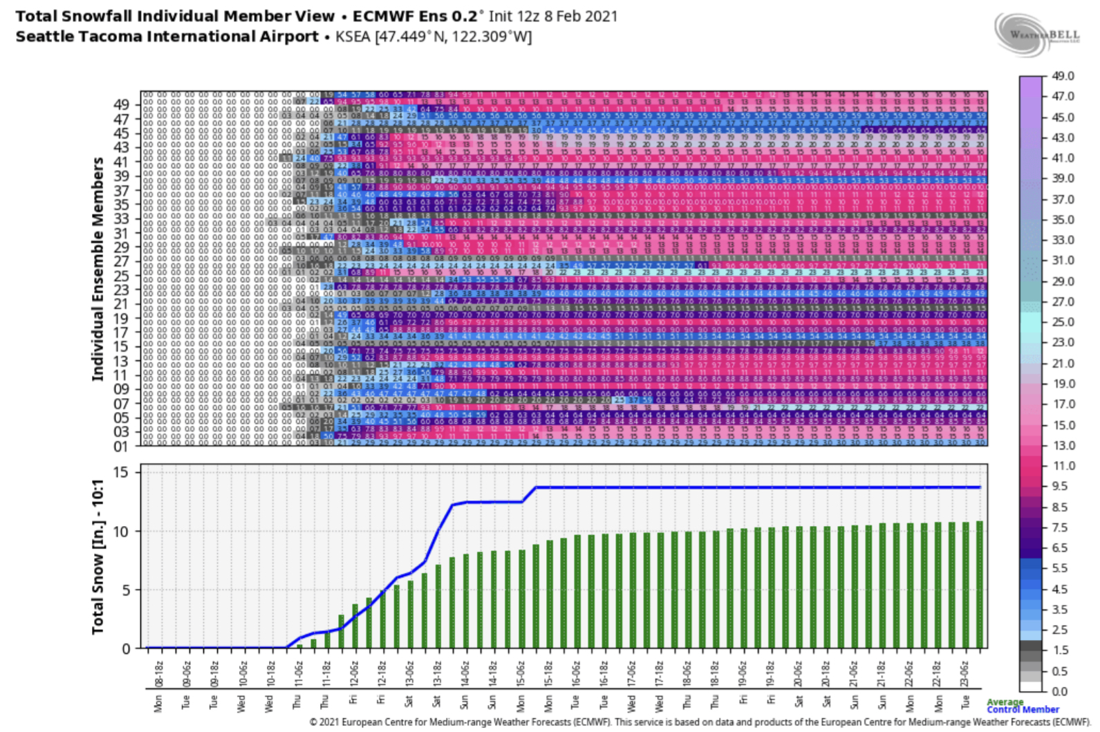
Below is the European Model's ensemble for SeaTac airport. Add a couple inches to these predictions if you live south of there.

Image from Cliff Mass Weather Blog and WeatherBell.

Nearly every member of the ensemble predicts a major snow event. The bottom half of the graphic shows the averages. Bottom line: the skillful Euro model is confident in at least 10 inches of snow at SeaTac (11-12 inches south of the airport).

Now, the slightly less skillful GFS (American) forecast model (also for SeaTac airport).

Image from Cliff Mass Weather Blog and WeatherBell.

The GFS model is also pretty confident in a major snowstorm, with at least 8 inches likely among the ensembles.

What does this mean?

Well...nothing is absolutely certain yet, but be prepared for a major snow event, with totals of 6-15 inches, starting Friday afternoon and ending on Saturday.

What happens after midday Saturday is still uncertain. A changeover to rain or rain/snow mix by Saturday afternoon is possible, but confidence isn't high enough to determine that yet.

The next system, slated for Sunday/Monday, is too far out for us to accurately know what will happen.

As far as impacts to roads go...the temperature will play a big part. In the forecast for Puyallup (below...from weather.com), we see that temperatures on Friday will stay near/below freezing, keeping the ground cold. That means that snow is more likely to accumulate on roads.


Similar, or colder, temperatures are likely around the area. Don't be surprised if either one of our 2 storms brings snow accumulating at least on side streets.

Please stay tuned for updates! I will have nightly updates until this event is over.

Tuesday, February 9, 2021

Significant Snow Event Possible Starting Thursday

It now appears increasingly likely that a significant snow event will occur starting Thursday morning. 

This event will likely bring 2-6 inches of snow from Seattle southward, with the most snow from South Seattle to Centralia.

A Winter Storm Watch (text below) has been issued for the blue shaded areas. 


Let's dive in to the data.

I want to stress that since last night, the GFS model has come into agreement with the Euro model on a snowstorm. This is a change from last night when the GFS wasn't forecasting much snow. Agreement among forecast models = better likelihood of event happening.

Below is the Euro model showing snow through 10 PM Thursday.

Image from Cliff Mass Weather Blog and WeatherBell.

This prediction gives approximately 4 inches of snow from SeaTac southward.

Keeping with the Euro model, here is its total snow by 10 PM Friday.

Image from Cliff Mass Weather Blog and WeatherBell.

Wow! If this prediction verifies, 8-14 inches of snow will have fallen. Remember that while 8-14 inches of snow will fall, less of that will accumulate (due to settling, melting, etc.).

Remember that this is just one forecast. A forecast isn't complete until we see multiple solutions.

To show a different forecast, below is a graphic from NWS Seattle, showing expected snow through 10 AM Friday.


The NWS forecast shows 2-6 inches of snow in the South Sound, including Puyallup.

Bottom Line: I would expect anywhere from 4-14 inches of snow in the South/Central Sound by Friday night. 

The question now is not if or when it will snow, but instead how much will it snow.

Here's a good way to visualize the Puyallup/Tacoma area snowfall:

Least Possible: 1-2 inches

Most Likely: 2-6 inches

Highest Possible: 10-14 inches

As if this isn't enough, another potentially larger and more widespread snow event is possible on Saturday.

Some forecasts have indicated Saturday being a major event, with large totals and big impacts. However, it is simply too early to tell what will happen on Saturday and beyond (so stay tuned).

Below is a great graphic from NWS Seattle showing what to expect for this upcoming winter weather event.


Wednesday morning temperatures will be 26-32 degrees. Just a preview of the potential 17-25 degree lows for Thursday-Saturday.

Additionally, cold wind chills, winds out of the Cascade gaps, and very cold temperatures Thursday-Sunday are all in the cards. Snow is NOT our only talking point in this event.

It is best to stay tuned as details will likely fluctuate. As a reminder, I will have daily updates as long as this event continues.


Monday, February 8, 2021

Monday Night Update: Certain Cold, Uncertain Snow

We are certain that Western Washington will be plunged into the freezer this week. However, with that cold comes the potential for lowland snow. The snow potential is uncertain right now. 

This graphic from NWS Seattle illustrates what we know, don't know, and what you should do.


Let's take a look at the temperature forecast. Below is the forecast for Puyallup from The Weather Channel.


Temperatures get progressively colder all week, bottoming out on Friday. It is important to note that temperatures can, and possibly will, get colder than this forecast indicates.

Do not rule out low temperatures of 17-23 degrees from Thursday to Saturday.

Additionally, brisk N-NE winds will bring very cold wind chills of 10-20 degrees from Thursday through Saturday. Even colder wind chills, down to the single digits, are possible in wind gusts. 

Expect N-NE winds of 10-15 mph, with gusts of 15-30 mph. The 20+ mph gusts combined with temperatures not exceeding freezing are what form these dangerous wind chills. Below is an informative graphic from the NWS about the science of wind chill.


Now for what you really want to know about...the potential of lowland snow later this week. The bottom line for current snow potential is that snow chances are uncertain. 

As of Monday night, there are 2 possible times for snow events.

Chance #1: Wednesday night/Thursday morning (smaller-impact event)
On Wednesday night, a modified arctic front will move through the Puget Sound area, bringing colder temperatures and a chance of snow. This snow chance is not very likely, but should it occur, expect an area of heavier snow (2-5") between SeaTac and Seattle (and eastward), with lesser amounts (0.5-1.5 inches) in the South Sound.

Chance #2: Thursday into Saturday (potentially larger-impact event)
In weather forecasting, forecasts are generally determined by forecast models, which are systems that predict upcoming weather. 2 major forecast models are the European Model (aka “Euro” or ECMWF) and the American Model (GFS).

Below is the Euro model ensemble forecast (many forecasts put together) for SeaTac airport. Most of the ensemble members show significant snow (5-18 inches) at SeaTac airport.

Image courtesy Cliff Mass Weather Blog and WeatherBell.

The Euro model gives an average of 10-14 inches of snow through Monday at SeaTac Airport. I’d add a couple inches to that prediction for the South Sound.

However, a forecast isn’t good unless you compare multiple predictions.

Below is another forecast ensemble, but instead from the GFS (American) Model.

Image courtesy Cliff Mass Weather Blog and WeatherBell.


Far less ensemble members show heavy snow, with an average at SeaTac airport of 5-7 inches. I’d expect about the same for the South Sound in this scenario.

Bottom line: The Euro says 10-14 inches, the GFS says 5-7 inches, and the GFS has been trending lesser on snow amounts across the Puget Sound area.

This all means that there’s A LOT of uncertainty. (Would it be a Seattle snowstorm without uncertainty??) 

Expect that through the next couple days we will see forecasts start to align a bit more on a solution...but until then, stay tuned. Lots will change.

I will be posting nightly updates on the blog as this winter weather situation continues. Be sure to check back each night!


Short Spring Heat Wave for the Pacific Northwest

  FastCast--Thursday, May 9 to Tuesday, May 14: A spring "heat wave" is ahead for the Northwest, with the warmest temperatures see...