It now appears increasingly likely that a significant snow event will occur starting Thursday morning.
This event will likely bring 2-6 inches of snow from Seattle southward, with the most snow from South Seattle to Centralia.
A Winter Storm Watch (text below) has been issued for the blue shaded areas.
Let's dive in to the data.
I want to stress that since last night, the GFS model has come into agreement with the Euro model on a snowstorm. This is a change from last night when the GFS wasn't forecasting much snow. Agreement among forecast models = better likelihood of event happening.
Below is the Euro model showing snow through 10 PM Thursday.
 |
| Image from Cliff Mass Weather Blog and WeatherBell. |
This prediction gives approximately 4 inches of snow from SeaTac southward.
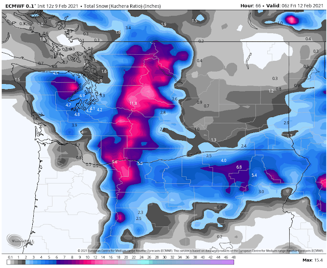
Keeping with the Euro model, here is its total snow by 10 PM Friday.
 |
| Image from Cliff Mass Weather Blog and WeatherBell. |
Remember that this is just one forecast. A forecast isn't complete until we see multiple solutions.
To show a different forecast, below is a graphic from NWS Seattle, showing expected snow through 10 AM Friday.
The NWS forecast shows 2-6 inches of snow in the South Sound, including Puyallup.
Bottom Line: I would expect anywhere from 4-14 inches of snow in the South/Central Sound by Friday night.
The question now is not if or when it will snow, but instead how much will it snow.
Here's a good way to visualize the Puyallup/Tacoma area snowfall:
Least Possible: 1-2 inches
Most Likely: 2-6 inches
Highest Possible: 10-14 inches
As if this isn't enough, another potentially larger and more widespread snow event is possible on Saturday.
Some forecasts have indicated Saturday being a major event, with large totals and big impacts. However, it is simply too early to tell what will happen on Saturday and beyond (so stay tuned).
Below is a great graphic from NWS Seattle showing what to expect for this upcoming winter weather event.
Wednesday morning temperatures will be 26-32 degrees. Just a preview of the potential 17-25 degree lows for Thursday-Saturday.
Additionally, cold wind chills, winds out of the Cascade gaps, and very cold temperatures Thursday-Sunday are all in the cards. Snow is NOT our only talking point in this event.
It is best to stay tuned as details will likely fluctuate. As a reminder, I will have daily updates as long as this event continues.


I sure hope we get some snow! Thanks for the information!
ReplyDelete